
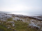
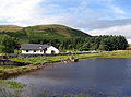
Loch Thom
Encyclopedia


Greenock
Greenock is a town and administrative centre in the Inverclyde council area in United Kingdom, and a former burgh within the historic county of Renfrewshire, located in the west central Lowlands of Scotland...
in Inverclyde
Inverclyde
Inverclyde is one of 32 council areas used for local government in Scotland. Together with the Renfrewshire and East Renfrewshire council areas, Inverclyde forms part of the historic county of Renfrewshire - which current exists as a registration county and lieutenancy area - located in the west...
, Scotland
Scotland
Scotland is a country that is part of the United Kingdom. Occupying the northern third of the island of Great Britain, it shares a border with England to the south and is bounded by the North Sea to the east, the Atlantic Ocean to the north and west, and the North Channel and Irish Sea to the...
. It is named after the civil engineer
Civil engineering
Civil engineering is a professional engineering discipline that deals with the design, construction, and maintenance of the physical and naturally built environment, including works like roads, bridges, canals, dams, and buildings...
Robert Thom
Robert Thom (engineer)
Robert Thom was a Scottish civil engineer who worked upon major hydraulic projects on the Isle of Bute and Inverclyde. On Bute, he created aquaducts to increase the flow of water which powered the cotton mills there, so that their capacity was increased. This economic success resulted in him...
who designed the scheme which created the reservoir and delivered water via a long aqueduct
Aqueduct
An aqueduct is a water supply or navigable channel constructed to convey water. In modern engineering, the term is used for any system of pipes, ditches, canals, tunnels, and other structures used for this purpose....
known as The Cut. Today, as well as providing a water supply, the loch is used for sport fishing and forms part of the Clyde Muirshiel Regional Park
Clyde Muirshiel Regional Park
Clyde Muirshiel Regional Park is the collective name for areas of countryside set aside for conservation and recreation on the South Clyde estuary in Scotland....
with several attractive walks and a centre at Cornalees Bridge providing nature study facilities.
Loch Thom
In the late 18th century Greenock was a rapidly expanding seaport with industries developing as the industrial revolutionIndustrial Revolution
The Industrial Revolution was a period from the 18th to the 19th century where major changes in agriculture, manufacturing, mining, transportation, and technology had a profound effect on the social, economic and cultural conditions of the times...
gathered pace. Its location on the north slopes of hills sweeping down to the south bank of the Firth of Clyde
Firth of Clyde
The Firth of Clyde forms a large area of coastal water, sheltered from the Atlantic Ocean by the Kintyre peninsula which encloses the outer firth in Argyll and Ayrshire, Scotland. The Kilbrannan Sound is a large arm of the Firth of Clyde, separating the Kintyre Peninsula from the Isle of Arran.At...
meant that several fast flowing streams provided supplies, and a number of wells provided clean water for domestic use. This was supplemented in 1773 by a piped water system designed by James Watt
James Watt
James Watt, FRS, FRSE was a Scottish inventor and mechanical engineer whose improvements to the Newcomen steam engine were fundamental to the changes brought by the Industrial Revolution in both his native Great Britain and the rest of the world.While working as an instrument maker at the...
supplying some areas, but there was increasing demand for water powered mills.
On the far side of the hills to the south of the town a natural dip held a freshwater lake known as Shaws Water at a level high above the town. The civil engineer Robert Thom from Rothesay
Rothesay, Argyll and Bute
The town of Rothesay is the principal town on the Isle of Bute, in the council area of Argyll and Bute, Scotland. It can be reached by ferry from Wemyss Bay which offers an onward rail link to Glasgow. At the centre of the town is Rothesay Castle, a ruined castle which dates back to the 13th...
prepared a scheme to turn this into a reservoir and create the aqueduct
Aqueduct
An aqueduct is a water supply or navigable channel constructed to convey water. In modern engineering, the term is used for any system of pipes, ditches, canals, tunnels, and other structures used for this purpose....
which became known as The Cut. The Shaws Water Joint Stock Company was incorporated on 10 June 1825 with capital of £30,000, and the scheme was officially opened on 16 April 1827. On that day a grain mill, paper mill, power loom manufactory and a sugar refinery made use of the power from the water running north down to the sea for a vertical height of around 170 m, at a rate of about 21000 cubic feet (594.7 m³) of water per day. In 1845 The Kelly Cut was constructed to bring more water to Loch Thom from the south. Numerous other mills were added in Greenock to make use of the supply, including what became The Merino Mills weaving woollen cloth, and a mill grinding clay for a local pottery works.
The loch is about 2.4 km from north to south, curving to the east in a rough C-shape, and is at an elevation of about 195 m above sea level. From the northern arm an outlet feeds southwest a short distance to a compensation reservoir at the centre of the "C", which then connects at Cornalees Bridge to the start of The Cut. The water supply proved inadequate for growing domestic demand, and in 1872 another reservoir was created immediately to the east of Loch Thom at Gryffe Reservoir
Gryffe Reservoir
The Gryffe Reservoirs are two reservoirs, known as Gryffe No. 1 and Gryffe No. 2, located in Inverclyde in the west central Lowlands of Scotland....
. Together with thirteen smaller reservoirs nearby they provide almost 650,000,000 cubic feet (18,000,000 m³) of water supply in total
Greenock Cut Centre
Loch Thom forms part of Clyde Muirshiel Regional Park, a public organisation aimed at providing countryside access and education. Several nature trails are provided, and the Greenock Cut Centre adjacent to Cornalees Bridge provides educational facilities at a ranger base, along with car parking, refreshments and public toilets.Location:
The Cut
From Cornalees Bridge The Cut runs west then turns northward following along the contour of Dunrod Hill which it follows round until running eastwards directly above the town of Greenock at OvertonOverton, Greenock
Overton is an area in the suburbs of Greenock, Inverclyde. Overton offers excellent views across the River Clyde and suburban Greenock.The area is the closest in Greenock to "The Cut" which was completed in 1827, bringing a water supply from Loch Thom to Overton, where the Shaws Water Works...
, having come a distance of 9 km (5.6 mi). On the way it collects some of the water from streams that cross its path, and a series of sluice gates incorporated an ingenious automatic way of releasing surplus water.
From its opening the nearly level footpath formed on the embankment to the downhill side of the aqueduct proved a great attraction. and "walking the Cut" continues to be popular.
Literature
The poet W. S. GrahamW. S. Graham
William Sydney Graham was a Scottish poet who is often associated with Dylan Thomas and the neo-romantic group of poets. Graham's poetry was mostly overlooked in his lifetime but, partly due to the support of Harold Pinter, his work has enjoyed a revival in recent years...
's later work powerfully evokes his childhood in and around Greenock. In "Loch Thom", included in Implements in their Places, published in 1977, the loch becomes the focus of his memories:
The curlew's cry travelling still
Kills me fairly. In front of me
The grouse flurry and settle. GOBACK
GOBACK GOBACK FAREWELL LOCH THOM.
External links
- Clyde Muirsheil, includes sections on Cornalees and Greenock Cut
- Inverclyde Council – Walking, Parks and Outdoor Attractions
- Mountain bike routes at Loch Thom