

Climate of Georgia (U.S. state)
Encyclopedia
Climate
Climate encompasses the statistics of temperature, humidity, atmospheric pressure, wind, rainfall, atmospheric particle count and other meteorological elemental measurements in a given region over long periods...
of Georgia
Georgia (U.S. state)
Georgia is a state located in the southeastern United States. It was established in 1732, the last of the original Thirteen Colonies. The state is named after King George II of Great Britain. Georgia was the fourth state to ratify the United States Constitution, on January 2, 1788...
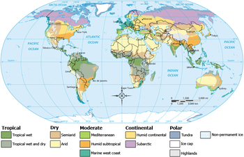
is typical of a humid subtropical climate
Humid subtropical climate
A humid subtropical climate is a climate zone characterized by hot, humid summers and mild to cool winters...
with most of the state having mild winters and hot summers. The Atlantic Ocean
Atlantic Ocean
The Atlantic Ocean is the second-largest of the world's oceanic divisions. With a total area of about , it covers approximately 20% of the Earth's surface and about 26% of its water surface area...
on the east coast of Georgia and the hill country in the north impact the state's climate. Also, the Chattahoochee River
Chattahoochee River
The Chattahoochee River flows through or along the borders of the U.S. states of Georgia, Alabama, and Florida. It is a tributary of the Apalachicola River, a relatively short river formed by the confluence of the Chattahoochee and Flint Rivers and emptying into Apalachicola Bay in the Gulf of...
divides Georgia into separate climatic regions with mountain region
North Georgia mountains
The Georgia Mountains Region or North Georgia mountains or Northeast Georgia is an area that starts in the northeast corner of Georgia, United States, and spreads in a westerly direction. The mountains in this region are in the Blue Ridge mountain chain that ends in Georgia...
to the northwest being colder than the rest of Georgia, the average temperature for that region in January and July being 39 °F (3.9 °C) and 78 °F (25.6 °C) respectively. Winter in Georgia is characterized by mild temperatures and little snowfall around the state, with colder, snowier, and icing most likely across northern and central Georgia. Many summer days in Georgia have been known to exceed 90 °F (32.2 °C). The state experiences widespread precipitation. Tornado
Tornado
A tornado is a violent, dangerous, rotating column of air that is in contact with both the surface of the earth and a cumulonimbus cloud or, in rare cases, the base of a cumulus cloud. They are often referred to as a twister or a cyclone, although the word cyclone is used in meteorology in a wider...
es and tropical cyclone
Tropical cyclone
A tropical cyclone is a storm system characterized by a large low-pressure center and numerous thunderstorms that produce strong winds and heavy rain. Tropical cyclones strengthen when water evaporated from the ocean is released as the saturated air rises, resulting in condensation of water vapor...
s are common.
Temperatures
The majority of Georgia is primarily a subtropical climate tempered somewhat by occasional polar air masses in the winter. Hot and humid summers are typical, except at the highest elevations. The degree to which the weather of a certain area of Georgia is depends not just on the latitudeLatitude
In geography, the latitude of a location on the Earth is the angular distance of that location south or north of the Equator. The latitude is an angle, and is usually measured in degrees . The equator has a latitude of 0°, the North pole has a latitude of 90° north , and the South pole has a...
, but also on how close it is to the Atlantic Ocean
Atlantic Ocean
The Atlantic Ocean is the second-largest of the world's oceanic divisions. With a total area of about , it covers approximately 20% of the Earth's surface and about 26% of its water surface area...
or Gulf of Mexico
Gulf of Mexico
The Gulf of Mexico is a partially landlocked ocean basin largely surrounded by the North American continent and the island of Cuba. It is bounded on the northeast, north and northwest by the Gulf Coast of the United States, on the southwest and south by Mexico, and on the southeast by Cuba. In...
and the altitude. This is especially true in the mountainous areas in the northern part of the state, which are further away from ocean waters and can be up to 4500 feet (1,371.6 m) or higher above sea level
Sea level
Mean sea level is a measure of the average height of the ocean's surface ; used as a standard in reckoning land elevation...
. The areas near the Florida/Georgia border, extending from the entire Georgia coastline west to the Florida panhandle, experiences the most subtropical weather, similar to that of Florida: hot, humid summers with frequent afternoon thunderstorms and mild, somewhat drier winters. This from Zakiya Rountree
In spite of having moderate weather compared to many other states, Georgia has occasional extreme weather. The highest temperature ever recorded is 112 °F (44.4 °C), while the lowest ever recorded is -17 F. Heat wave
Heat wave
A heat wave is a prolonged period of excessively hot weather, which may be accompanied by high humidity. There is no universal definition of a heat wave; the term is relative to the usual weather in the area...
s involving temperatures over 100 °F (37.8 °C) have been recorded in the past.
| Monthly average daily high and low temperatures for major Georgia cities | ||||||||||||
| City | Jan | Feb | Mar | Apr | May | Jun | Jul | Aug | Sep | Oct | Nov | Dec |
|---|---|---|---|---|---|---|---|---|---|---|---|---|
| Athens | 53/33 | 58/37 | 66/43 | 74/49 | 81/58 | 88/67 | 91/70 | 90/69 | 84/63 | 74/52 | 65/43 | 55/35 |
| Atlanta | 53/34 | 57/38 | 65/44 | 73/51 | 80/60 | 87/68 | 90/71 | 88/71 | 82/65 | 73/54 | 64/44 | 54/37 |
| Augusta | 56/33 | 61/36 | 69/44 | 77/50 | 84/59 | 90/68 | 92/75 | 90/75 | 85/71 | 76/57 | 68/42 | 59/35 |
| Columbus | 58/37 | 62/40 | 70/46 | 77/53 | 84/62 | 90/70 | 92/73 | 91/72 | 86/67 | 77/56 | 68/46 | 59/39 |
| Macon | 58/35 | 62/39 | 70/45 | 77/51 | 85/60 | 90/68 | 93/71 | 92/71 | 86/64 | 78/53 | 69/44 | 60/37 |
| Savannah | 60/42 | 64/45 | 71/52 | 78/57 | 84/65 | 90/72 | 92/76 | 90/75 | 86/71 | 78/60 | 70/51 | 63/44 |
| Temperatures are given in high (°F)/low (°F) format. | ||||||||||||
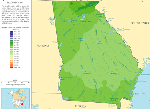
Precipitation
North Georgia mountains
The Georgia Mountains Region or North Georgia mountains or Northeast Georgia is an area that starts in the northeast corner of Georgia, United States, and spreads in a westerly direction. The mountains in this region are in the Blue Ridge mountain chain that ends in Georgia...
, receives moderate to heavy rain, which varies from 45 inches (1,143 mm) in central Georgia to approximately 75 inches (1,905 mm) around the Northeast part of the state. Georgia has had severe droughts in the past, especially in 2007. Tropical Storm Alberto in July 1994
Tropical Storm Alberto (1994)
Tropical Storm Alberto was the first storm of the 1994 Atlantic hurricane season. It hit Florida across the Southeast United States in July, causing a massive flooding disaster while stalling over Georgia and Alabama. Alberto caused $1 billion in damage and 30 deaths.-Meteorological history:A...
looped across central Georgia, leading to 24-hour rainfall amounts exceeding 20 inches (508 mm) across central sections of the state. It also became the wettest tropical cyclone on record for the state of Georgia, eclipsing the record set in 1929. Snowfall occurs most winters, which increases in frequency and average amounts per year the farther the north you go in Georgia.
Winter
Appalachian Mountains
The Appalachian Mountains #Whether the stressed vowel is or ,#Whether the "ch" is pronounced as a fricative or an affricate , and#Whether the final vowel is the monophthong or the diphthong .), often called the Appalachians, are a system of mountains in eastern North America. The Appalachians...
. The main winter weather hazard in northern Georgia is "freezing rain
Freezing rain
Freezing rain is the name given to rain that falls when surface temperatures are below freezing. The raindrops become supercooled while passing through a sub-freezing layer of air, many hundred feet , just above the surface, and then freeze upon impact with any object they encounter. The resulting...
- or rain which freezes upon contact with the ground - which is 2 inches (5.1 cm) or more of snow falling in a 12 hour period, or 4 inches (10.2 cm) or more in a 24 hour period." The exception to this is the mountain areas of Fannin
Fannin County, Georgia
Fannin County is a county located in the U.S. state of Georgia. It was created on January 21, 1854. As of 2000, the population was 19,798. The 2007 Census Estimate shows a population of 22,580...
, Gilmer
Gilmer County, Georgia
Gilmer County is a county located in the U.S. state of Georgia. It was created on December 3, 1832 and was named for George Rockingham Gilmer. As of 2000, the population was 23,456. The 2007 Census Estimate shows a population of 28,389...
, Pickens
Pickens County, Georgia
Pickens County is a county located in the U.S. state of Georgia. The 2000 Census showed a population of 22,983. The 2007 Census Estimate showed a population of 30,488...
, and other surrounding counties heavy snow is "3 inches (7.6 cm) or more of snow in a 12 hour period or 4 inches (10.2 cm) or more of snow in a 24 hour period". Watches for heavy snow are issued when a 50 percent or greater chance of 2 inches (5.1 cm) or more of snow falling in a 12 hour period, or 4 inches (10.2 cm) or more in a 24 hour period is expected. Again, there are exceptionsthan a trace of frozen precipitation has been recorded officially for Atlanta. The criteria for the mountain counties is "3 inches (7.6 cm) inches or more of snow in a 12 hour period or 4 inches (101.6 mm) or more of snow in a 24 hour period".
Winter weather watches are issued when there is a "50 percent or greater chance of significant and damaging accumulations of ice during freezing rain situations"; these watches are normally issued 12 to 48 hours in advance. A winter storm warning for an ice storm means that icy conditions are "occurring, imminent, or have a very high probability of occurring". These warnings are usually issued when there is an 80 percent or greater chance of meeting ice storm conditions.
It is rare in Georgia for blizzard
Blizzard
A blizzard is a severe snowstorm characterized by strong winds. By definition, the difference between blizzard and a snowstorm is the strength of the wind. To be a blizzard, a snow storm must have winds in excess of with blowing or drifting snow which reduces visibility to 400 meters or ¼ mile or...
s to occur. The last blizzard the state had was in March 1993.
Winter in South Georgia, which lasts from December to January, is much more mild. Daytime highs range from approximately 50 °F (10 °C) in the northernmost interior areas to near 70 °F (21.1 °C) along the coast and in the extreme south.
Spring
Weather during springtime in North Georgia and the mountains changes from day to day and year to year. Early spring in the North Georgia Mountains can be very chilly during the day; average highs are near 62 °F (16.7 °C). The weather can be highly variable with temperatures ranging between 75 °F (23.9 °C) and 40 °F (4.4 °C). The rainiest time of the year is normally April, which can also be a windy month where daytime temperatures can rise to near 75 °F (23.9 °C) and evening temperatures fall to around 40 °F (4.4 °C).Summer
Summers are hot and humid with temperatures in the afternoons that reach, on average, to near 90 °F (32.2 °C). Overnight lows fall to near 68 °F (20 °C) and there is usually an 8-10 degree FahrenheitFahrenheit
Fahrenheit is the temperature scale proposed in 1724 by, and named after, the German physicist Daniel Gabriel Fahrenheit . Within this scale, the freezing of water into ice is defined at 32 degrees, while the boiling point of water is defined to be 212 degrees...
(5 degree Celsius) difference in temperature between the mountains and Atlanta. While humidity in North Georgia, especially in the mountains, can be high it is not as high as it is in South Georgia. Summer thunderstorms add to the humidity in the area by providing 4.5 inches (114.3 mm) to 5.5 inches (139.7 mm) of rain during the summer months.
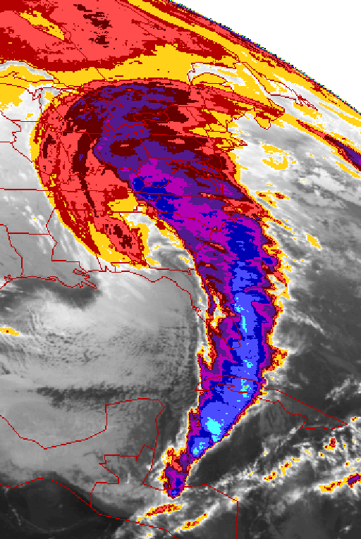
Tropical cyclones
.jpg)
Although Georgia experiences many tropical cyclone
Tropical cyclone
A tropical cyclone is a storm system characterized by a large low-pressure center and numerous thunderstorms that produce strong winds and heavy rain. Tropical cyclones strengthen when water evaporated from the ocean is released as the saturated air rises, resulting in condensation of water vapor...
s, it only rarely experiences a direct hurricane strike due to its fairly small coastline. The last hurricane to directly affect the Georgia coastline was Hurricane David
Hurricane David
Hurricane David was the fourth named tropical cyclone, second hurricane, and first major hurricane of the 1979 Atlantic hurricane season. A Category 5 hurricane on the Saffir-Simpson Hurricane Scale, David was among the deadliest hurricanes in the latter half of the 20th century, killing...
in 1979. The last major hurricane (Category 3 or higher) to hit the Georgia coast directly was in 1898. More common are hurricanes which strike the Florida Panhandle
Florida Panhandle
The Florida Panhandle, an informal, unofficial term for the northwestern part of Florida, is a strip of land roughly 200 miles long and 50 to 100 miles wide , lying between Alabama on the north and the west, Georgia also on the north, and the Gulf of Mexico to the south. Its eastern boundary is...
, weaken over land, and bring tropical storm or hurricane force winds and heavy rain to the Georgia interior (especially the southwestern areas), as well as hurricanes that come close to the Georgia coastline, brushing the coast on their way up to hit the Carolinas
The Carolinas
The Carolinas is a term used in the United States to refer collectively to the states of North and South Carolina. Together, the two states + have a population of 13,942,126. "Carolina" would be the fifth most populous state behind California, Texas, New York, and Florida...
.
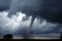
Tornadoes
Fujita scale
The Fujita scale , or Fujita-Pearson scale, is a scale for rating tornado intensity, based primarily on the damage tornadoes inflict on human-built structures and vegetation...
tornadoes associated with summer afternoon thunderstorms. However, tornadoes of F3 intensity or greater within Georgia are uncommon, with three events reported on average each year.
Fall
Georgia's autumns are normally sunny and cool. September and October, the driest months of the year, qualify as "Indian SummerIndian summer
An Indian summer is a meteorological phenomenon that occurs in the autumn. It refers to a period of considerably above normal temperatures, accompanied by dry and hazy conditions, usually after there has been a killing frost...
" weather with temperatures that are near 78 °F (25.6 °C) during the daytime. At night, the temperature drops to near 50 °F (10 °C). It is much cooler in November with an average high of 62 °F (16.7 °C) and low of 36 °F (2.2 °C). The first freeze of the year normally falls within November, except in the northern mountains, where it occurs in October.
See also
- List of wettest known tropical cyclones in Georgia