

Clastic dike
Encyclopedia
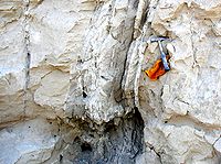
A clastic dike is a seam of sedimentary material that fills a crack in and cuts across sedimentary strata
. Clastic dikes form rapidly by fluidized injection (mobilization of pressurized pore fluids) or passively by water, wind, and gravity (sediment swept into open cracks). Diagenesis may play a role in the formation of some dikes. Clastic dikes are commonly vertical or near-vertical. Centimetre-scale widths are common, but thicknesses range from millimetres to metres. Length is usually many times width.
Clastic dikes are found in sedimentary basin deposits worldwide. Formal geologic reports of clastic dikes began to emerge in the early 19th century.
Terms synonymous with clastic dike include: clastic intrusion, fissure fill, soft-sediment deformation, fluid escape structure, seismite, injectite, liquefaction feature, neptunian dike, paleoseismic indicator, pseudo ice wedge cast, sedimentary insertion, sheeted clastic dike, synsedimentary filling, tension fracture, and tempestite.
 Tens of thousands of unusual clastic dikes (1 mm—350 cm wide) in Pleistocene
sediments of southeastern Washington may be related to loading by outburst floods. Saturated material was injected along and enlarged preexisting weaknesses (shallow frost or desiccation cracks, joints in bedrock). Other lines of evidence suggest that these dikes may have formed when the flood-deposited Touchet Formation
dried, leaving deep, open cracks which subsequently filled with debris. That would mean they are desiccation features — cracks formed as wet sediment dried and contracted. If desiccation features, the dikes would have formed by passive infilling of open fractures by windblown or washed in sediment over time. Some evidence suggests the dikes are fossil ice wedge
casts or features related to the melting of buried ice. There is good proxy evidence for cold-climate conditions (periglacial
or nearly so) at the time of their formation. The origin of the clastic dikes in the Columbia Basin
is under debate.
Dikes sourced in Touchet Beds (or Touchet-like deposits of similar age and depositional history) are known to intrude downward into older geologic units including the Pleistocene Clearwater Gravels in the Lewiston Basin, pre-late Wisconsin deposits in the Walla Walla Valley and Columbia Basin, Miocene—Pliocene Snipes Mountain Conglomerate, in the Yakima Valley, Miocene—Pliocene Ringold Formation, Miocene Columbia River Basalt Group at Gable Mountain, and the Walla Walla Valley, and possibly the Alkali Canyon Fm (Dalles Group) in the Willow Creek Valley at Cecil, Oregon.
Stratum
In geology and related fields, a stratum is a layer of sedimentary rock or soil with internally consistent characteristics that distinguish it from other layers...
. Clastic dikes form rapidly by fluidized injection (mobilization of pressurized pore fluids) or passively by water, wind, and gravity (sediment swept into open cracks). Diagenesis may play a role in the formation of some dikes. Clastic dikes are commonly vertical or near-vertical. Centimetre-scale widths are common, but thicknesses range from millimetres to metres. Length is usually many times width.
Clastic dikes are found in sedimentary basin deposits worldwide. Formal geologic reports of clastic dikes began to emerge in the early 19th century.
Terms synonymous with clastic dike include: clastic intrusion, fissure fill, soft-sediment deformation, fluid escape structure, seismite, injectite, liquefaction feature, neptunian dike, paleoseismic indicator, pseudo ice wedge cast, sedimentary insertion, sheeted clastic dike, synsedimentary filling, tension fracture, and tempestite.
Environments of formation
Clastic dike environments include:- Clastic dikes associated with earthquakes -
- An incredible variety of dikes is found in the geologic record. However, clastic dikes are typically produced by seismic disturbance and liquefaction of high water content sediments. Examples of this type are many. Clastic dikes are paleoseismic indicators in certain geologic settings. Several qualitative, field-based systems have been developed to help distinguish seismites from soft sediment deformation features formed by non-seismic processes.
- Results from analytical modeling of clastic dike injection in soft Pleistocene-age rocks of the Ami'az Plain, Israel indicate propagation occurred at a rate of approximately 4 to 65 m/sec at driving pressures of 1-2 MPa. Emplacement duration (<2 sec) appears similar to the speed with which acoustic energy (pressure waves) moves through young, partially-lithified sedimentary rock.
- Clastic dikes associated with debris flows -
- Sandstone dikes formed by downward injection are found along Black Dragon wash upstream of the famous petroglyphs area, San Rafael Swell, UT.
- Clastic dikes associated with impact craters -
- Sandstone dikes with cataclastically deformed sand grains, sourced in the Permian White Rim Sandstone, are found within Upheaval DomeUpheaval DomeUpheaval Dome is an impact structure, the deeply eroded remnants of an impact crater, in Canyonlands National Park near the town Moab, Utah, in the United States....
, Canyonlands National ParkCanyonlands National ParkCanyonlands National Park is a U.S. National Park located in southeastern Utah near the town of Moab and preserves a colorful landscape eroded into countless canyons, mesas and buttes by the Colorado River, the Green River, and their respective tributaries. The park is divided into four districts:...
, UtahUtahUtah is a state in the Western United States. It was the 45th state to join the Union, on January 4, 1896. Approximately 80% of Utah's 2,763,885 people live along the Wasatch Front, centering on Salt Lake City. This leaves vast expanses of the state nearly uninhabited, making the population the...
, at Roberts Rift, and elsewhere.
- Clastic dikes associated with salt domes -
- Clastic dike swarms associated with salt domeSalt domeA salt dome is a type of structural dome formed when a thick bed of evaporite minerals found at depth intrudes vertically into surrounding rock strata, forming a diapir....
diapirDiapirA diapir is a type of intrusion in which a more mobile and ductily-deformable material is forced into brittle overlying rocks. Depending on the tectonic environment, diapirs can range from idealized mushroom-shaped Rayleigh-Taylor instability-type structures in regions with low tectonic stress...
ism is reported from the Dead SeaDead SeaThe Dead Sea , also called the Salt Sea, is a salt lake bordering Jordan to the east and Israel and the West Bank to the west. Its surface and shores are below sea level, the lowest elevation on the Earth's surface. The Dead Sea is deep, the deepest hypersaline lake in the world...
region.
- Clastic dikes associated with glaciers -
- Sand injection features are reported to have formed under heavy loads and confining pressures beneath grounding glacial ice.
- Clastic dikes in resistant bedrock -
- Though unusual, a significant number of reports describe sedimentary material intruding fractured crystalline bedrock, usually within fault zones.
- Clastic dikes in storm deposits -
- Cyclic stresses from large waves can cause wet sediments to fluidize, forming various types of soft sediment deformation features including clastic dikes.
Clastic dikes in Missoula flood deposits
Pleistocene
The Pleistocene is the epoch from 2,588,000 to 11,700 years BP that spans the world's recent period of repeated glaciations. The name pleistocene is derived from the Greek and ....
sediments of southeastern Washington may be related to loading by outburst floods. Saturated material was injected along and enlarged preexisting weaknesses (shallow frost or desiccation cracks, joints in bedrock). Other lines of evidence suggest that these dikes may have formed when the flood-deposited Touchet Formation
Touchet Formation
The Touchet Formation or Touchet beds consist of large quantities of gravel and fine sediment which overlay almost a thousand meters of volcanic basalt of the Columbia River Basalt Group in south-central Washington and north-central Oregon...
dried, leaving deep, open cracks which subsequently filled with debris. That would mean they are desiccation features — cracks formed as wet sediment dried and contracted. If desiccation features, the dikes would have formed by passive infilling of open fractures by windblown or washed in sediment over time. Some evidence suggests the dikes are fossil ice wedge
Ice wedge
An ice wedge is a crack in the ground formed by a narrow or thin piece of ice that measures up to 3-4 metres wide at ground level and extends downwards into the ground up to several metres. During the winter months, the water in the ground freezes and expands...
casts or features related to the melting of buried ice. There is good proxy evidence for cold-climate conditions (periglacial
Periglacial
Periglacial is an adjective originally referring to places in the edges of glacial areas, but it has later been widely used in geomorphology to describe any place where geomorphic processes related to freezing of water occur...
or nearly so) at the time of their formation. The origin of the clastic dikes in the Columbia Basin
Columbia Basin
The Columbia Basin, the drainage basin of the Columbia River, occupies a large area–about —of the Pacific Northwest region of North America. In common usage, the term often refers to a smaller area, generally the portion of the drainage basin that lies within eastern Washington.Usage of the term...
is under debate.
Dikes sourced in Touchet Beds (or Touchet-like deposits of similar age and depositional history) are known to intrude downward into older geologic units including the Pleistocene Clearwater Gravels in the Lewiston Basin, pre-late Wisconsin deposits in the Walla Walla Valley and Columbia Basin, Miocene—Pliocene Snipes Mountain Conglomerate, in the Yakima Valley, Miocene—Pliocene Ringold Formation, Miocene Columbia River Basalt Group at Gable Mountain, and the Walla Walla Valley, and possibly the Alkali Canyon Fm (Dalles Group) in the Willow Creek Valley at Cecil, Oregon.