

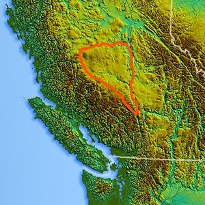
Chilcotin Plateau
Encyclopedia
Fraser Plateau
The Fraser Plateau is an intermontane plateau. It is one of the main subdivisions of the Interior Plateau located in the Central Interior of British Columbia, and includes the Cariboo and Chilcotin Plateaus and the adjoining Marble, Clear and Camelsfoot Ranges on its southwestern edge...
, a major subdivision of the Interior Plateau
Interior Plateau
The Interior Plateau comprises a large region of central British Columbia, and lies between the Cariboo and Monashee Mountains on the east, and the Hazelton Mountains, Coast Mountains and Cascade Range on the west. The continuation of the plateau into the United States is known there as the...
of British Columbia
British Columbia
British Columbia is the westernmost of Canada's provinces and is known for its natural beauty, as reflected in its Latin motto, Splendor sine occasu . Its name was chosen by Queen Victoria in 1858...
. The Chilcotin Plateau is physically near-identical with the region of the same name, i.e. "the Chilcotin"
Chilcotin District
The Chilcotin District of British Columbia is usually known simply as "the Chilcotin", and also in speech commonly as "the Chilcotin Country" or simply Chilcotin. It is a plateau and mountain region in British Columbia on the inland lea of the Coast Mountains on the west side of the Fraser River....
, which lies between the Fraser River
Fraser River
The Fraser River is the longest river within British Columbia, Canada, rising at Fraser Pass near Mount Robson in the Rocky Mountains and flowing for , into the Strait of Georgia at the city of Vancouver. It is the tenth longest river in Canada...
and the southern Coast Mountains
Coast Mountains
The Coast Mountains are a major mountain range, in the Pacific Coast Ranges, of western North America, extending from southwestern Yukon through the Alaska Panhandle and virtually all of the Coast of British Columbia. They are so-named because of their proximity to the sea coast, and are often...
and is defined by the basin of the Chilcotin River
Chilcotin River
The Chilcotin River is a long tributary of the Fraser River in southern British Columbia, Canada. It drains the Chilcotin Plateau, which lies between the Fraser River and the Coast Mountains...
and so includes montane areas beyond the plateau. East of the Chilcotin Plateau, across the Fraser River
Fraser River
The Fraser River is the longest river within British Columbia, Canada, rising at Fraser Pass near Mount Robson in the Rocky Mountains and flowing for , into the Strait of Georgia at the city of Vancouver. It is the tenth longest river in Canada...
, is the Cariboo Plateau
Cariboo Plateau
The Cariboo Plateau is a volcanic plateau in south-central British Columbia, Canada. It is part of the Fraser Plateau that itself is a northward extension of the North American Plateau...
, while to the north beyond the West Road (Blackwater) River
West Road River
The West Road River or Blackwater River is a major tributary of the Fraser River, flowing generally north-eastward from the northern slopes of the Ilgachuz Range and across the Fraser Plateau in the Chilcotin region of central British Columbia, Canada...
is the Nechako Plateau
Nechako Plateau
The Nechako Plateau is the northernmost subdivision of the Interior Plateau, one of the main geographic regions of the Canadian province of British Columbia...
. West and south of the Chilcotin Plateau are various subdivisions of the Coast Mountains
Coast Mountains
The Coast Mountains are a major mountain range, in the Pacific Coast Ranges, of western North America, extending from southwestern Yukon through the Alaska Panhandle and virtually all of the Coast of British Columbia. They are so-named because of their proximity to the sea coast, and are often...
, including the Chilcotin Ranges
Chilcotin Ranges
The Chilcotin Ranges are a subdivision of the Pacific Ranges of the Coast Mountains . They lie on the inland lea of the Pacific Ranges, abutting the Interior Plateau of British Columbia...
which lie along the plateau's southwest.
Included within the definition of the Chilcotin Plateau are the Rainbow Range
Rainbow Range (Coast Mountains)
The Rainbow Range, formerly known as the Rainbow Mountains, is a mountain range in British Columbia, Canada, located northwest of Anahim Lake...
, near Bella Coola
Bella Coola, British Columbia
Bella Coola is a community of approximately 600 at the western extremity of the Bella Coola Valley. Bella Coola usually refers to the entire valley, encompassing the settlements of Bella Coola proper , Lower Bella Coola, Hagensborg, Saloompt, Nusatsum, Firvale and Stuie...
and the similarly-volcanic Ilgachuz Range
Ilgachuz Range
The Ilgachuz Range is a name given to an extinct shield volcano in British Columbia, Canada. It is not a mountain range in the normal sense, because it was formed as a single volcano that has been eroded for the past 5 million years. It lies on the Chilcotin Plateau, located some north-northwest...
and Itcha Range
Itcha Range
The Itcha Range is a mountain range on the Chilcotin Plateau of the West-Central Interior of British Columbia, Canada. The range is located 25 miles northeast of Anahim Lake...
both of which are major shield volcano
Shield volcano
A shield volcano is a type of volcano usually built almost entirely of fluid lava flows. They are named for their large size and low profile, resembling a warrior's shield. This is caused by the highly fluid lava they erupt, which travels farther than lava erupted from more explosive volcanoes...
es. The Camelsfoot Range
Camelsfoot Range
The Camelsfoot Range is a sub-range of the Chilcotin Ranges subdivision of the Pacific Ranges of the Coast Mountains in British Columbia.* The range is c...
, north of Lillooet
Lillooet, British Columbia
Lillooet is a community on the Fraser River in western Canada, about up the British Columbia Railway line from Vancouver. Situated at an intersection of deep gorges in the lee of the Coast Mountains, it has a dry climate- of precipitation is recorded annually at the town's weather station,...
, is included in the Chilcotin Plateau by some systems of classification.
The plateau is nearly entirely drained by the Chilcotin River
Chilcotin River
The Chilcotin River is a long tributary of the Fraser River in southern British Columbia, Canada. It drains the Chilcotin Plateau, which lies between the Fraser River and the Coast Mountains...
and its tributaries, the largest of which are the Chilanko
Chilanko River
The Chilanko River is a river in the Chilcotin District of the Central Interior region of the Canadian province of British Columbia.The name of the river derives from a Chilcotin word meaning "many beaver river".-Course:...
and Chilko River
Chilko River
The Chilko River is a 75 km waterway in the Chilcotin District of the Central Interior of British Columbia, Canada, connecting Chilko Lake to the Chilcotin River. Its main tributary is the Taseko River....
s. Also draining the plateau on its eastern edge is Churn Creek
Churn Creek
Churn Creek is a tributary of the Fraser River in the Canadian province of British Columbia.-Course:Churn Creek flows generally northeast, joining the Fraser River just south of the headquarters of the Gang Ranch and opposite the community of Dog Creek and associated creek...
, which forms the east flank of the Camelsfoot Range
Camelsfoot Range
The Camelsfoot Range is a sub-range of the Chilcotin Ranges subdivision of the Pacific Ranges of the Coast Mountains in British Columbia.* The range is c...
and enters the Fraser
Fraser River
The Fraser River is the longest river within British Columbia, Canada, rising at Fraser Pass near Mount Robson in the Rocky Mountains and flowing for , into the Strait of Georgia at the city of Vancouver. It is the tenth longest river in Canada...
directly. On the west side of the plateau, the basins of the Dean
Dean River
The Dean River is one of the major rivers of the Kitimat Ranges subrange of the southern Coast Mountains in British Columbia. It begins in the volcanic-shield Ilgachuz Range on the Chilcotin Plateau and winds north around the Rainbow Range to enter Dean Channel at the now-uninhabited, remote...
, Homathko
Homathko River
The Homathko River is one of the major rivers of the southern Coast Mountains of British Columbia, and one of the few rivers that penetrates the range from the Chilcotin Plateau to the coastal inlets, entering the sea at the head of Bute Inlet adjacent to the mouth of the Southgate River, just to...
and Atnarko River
Atnarko River
The Atnarko River is a river in the Canadian province of British Columbia.-Course:The Atnarko River flows originates at Charlotte Lake. It flows generally west for approximately , joining the Telchako River to form the Bella Coola River. For much of its length the river flows through Tweedsmuir...
s penetrate the massifs of the Coast Mountains
Coast Mountains
The Coast Mountains are a major mountain range, in the Pacific Coast Ranges, of western North America, extending from southwestern Yukon through the Alaska Panhandle and virtually all of the Coast of British Columbia. They are so-named because of their proximity to the sea coast, and are often...
and have their beginnings, or the early part of their courses, on the Chilcotin Plateau.
The Chilcotin Plateau consists of basalt
Basalt
Basalt is a common extrusive volcanic rock. It is usually grey to black and fine-grained due to rapid cooling of lava at the surface of a planet. It may be porphyritic containing larger crystals in a fine matrix, or vesicular, or frothy scoria. Unweathered basalt is black or grey...
ic lava
Lava
Lava refers both to molten rock expelled by a volcano during an eruption and the resulting rock after solidification and cooling. This molten rock is formed in the interior of some planets, including Earth, and some of their satellites. When first erupted from a volcanic vent, lava is a liquid at...
of the Chilcotin Group, a group of related volcanic rock
Volcanic rock
Volcanic rock is a rock formed from magma erupted from a volcano. In other words, it is an igneous rock of volcanic origin...
s that is nearly parallel with the Fraser Plateau
Fraser Plateau
The Fraser Plateau is an intermontane plateau. It is one of the main subdivisions of the Interior Plateau located in the Central Interior of British Columbia, and includes the Cariboo and Chilcotin Plateaus and the adjoining Marble, Clear and Camelsfoot Ranges on its southwestern edge...
. It extends along the adjacent Garibaldi Volcanic Belt
Garibaldi Volcanic Belt
The Garibaldi Volcanic Belt, also called the Canadian Cascade Arc, is a northwest-southeast trending volcanic chain in the Pacific Ranges of the Coast Mountains that extends from Watts Point in the south to the Ha-Iltzuk Icefield in the north. This chain of volcanoes is located in southwestern...
in the Coast Mountains
Coast Mountains
The Coast Mountains are a major mountain range, in the Pacific Coast Ranges, of western North America, extending from southwestern Yukon through the Alaska Panhandle and virtually all of the Coast of British Columbia. They are so-named because of their proximity to the sea coast, and are often...
. Volcanism of the Chilcotin Plateau is considered to be a result of extension of the crust behind the coastal Cascadia subduction zone
Cascadia subduction zone
The Cascadia subduction zone is a subduction zone, a type of convergent plate boundary that stretches from northern Vancouver Island to northern California. It is a very long sloping fault that separates the Juan de Fuca and North America plates.New ocean floor is being created offshore of...
.