

Chignecto Bay
Encyclopedia

Inlet
An inlet is a narrow body of water between islands or leading inland from a larger body of water, often leading to an enclosed body of water, such as a sound, bay, lagoon or marsh. In sea coasts an inlet usually refers to the actual connection between a bay and the ocean and is often called an...
of the Bay of Fundy
Bay of Fundy
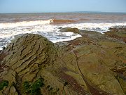
The Bay of Fundy is a bay on the Atlantic coast of North America, on the northeast end of the Gulf of Maine between the Canadian provinces of New Brunswick and Nova Scotia, with a small portion touching the U.S. state of Maine...
located between the Canadian
Canada
Canada is a North American country consisting of ten provinces and three territories. Located in the northern part of the continent, it extends from the Atlantic Ocean in the east to the Pacific Ocean in the west, and northward into the Arctic Ocean...
provinces of New Brunswick
New Brunswick
New Brunswick is one of Canada's three Maritime provinces and is the only province in the federation that is constitutionally bilingual . The provincial capital is Fredericton and Saint John is the most populous city. Greater Moncton is the largest Census Metropolitan Area...
and Nova Scotia
Nova Scotia
Nova Scotia is one of Canada's three Maritime provinces and is the most populous province in Atlantic Canada. The name of the province is Latin for "New Scotland," but "Nova Scotia" is the recognized, English-language name of the province. The provincial capital is Halifax. Nova Scotia is the...
and separated from the waters of the Northumberland Strait
Northumberland Strait
The Northumberland Strait is a strait in the southern part of the Gulf of Saint Lawrence in eastern Canada...
by the Isthmus of Chignecto
Isthmus of Chignecto
The Isthmus of Chignecto is an isthmus bordering the Maritime provinces of New Brunswick and Nova Scotia which connects the Nova Scotia peninsula with North America....
. It is a unit within the greater Gulf of Maine
Gulf of Maine
The Gulf of Maine is a large gulf of the Atlantic Ocean on the east coast of North America.It is delineated by Cape Cod at the eastern tip of Massachusetts in the southwest and Cape Sable at the southern tip of Nova Scotia in the northeast. It includes the entire coastlines of the U.S...
Watershed. Chignecto Bay forms the northeastern part of the Bay of Fundy which splits at Cape Chignecto
Cape Chignecto
Cape Chignecto is a headland located on the Bay of Fundy coast of the Canadian province of Nova Scotia.Cape Chignecto is located at the westernmost tip of Cumberland County and is the western limit of the Cobequid Hills, a low mountain range that is part of the Appalachian Mountains and extends...
and is delineated on the New Brunswick side by Martin Head.
- Cumberland Basin - the northeast arm of Chignecto Bay (and the Bay of Fundy) between the two provinces, terminating at the Tantramar MarshesTantramar MarshesThe Tantramar Marshes is a National Wildlife Area on the southern part of the Isthmus of Chignecto, which joins Nova Scotia to New Brunswick and the Canadian mainland. It is the site of the historic Battle of Fort Beauséjour, the final chapter in the long battle for Acadia by the British and French...
and the estuariesEstuaryAn estuary is a partly enclosed coastal body of water with one or more rivers or streams flowing into it, and with a free connection to the open sea....
of the Tantramar River and Maccan RiverMaccan RiverThe Maccan River is a small tidal river contained completely within Cumberland County, Nova Scotia. The river terminates at the confluence with River Hebert at Amherst Point, and empties into the Cumberland Basin. The river's tidal bore may be viewed from the Tidal Wetlands Park in...
. - Shepody BayShepody BayShepody Bay is a 122 km² coastal wetland in New Brunswick, Canada. It was designated a Ramsar wetland of international importance on May 27, 1987, is a globally significant Important Bird Area, and is part of the Western Hemisphere Shorebird Reserve Network...
- the north arm of Chignecto Bay and is wholly within New Brunswick. Its northern limit is formed at the estuaries of the PetitcodiacPetitcodiac RiverThe Petitcodiac River is a Canadian river in south-eastern New Brunswick. The river runs about through the province's Westmorland, Albert, and Kings counties, draining a watershed area of about . The region around the river features valleys, ridges, and rolling hills, and is home to a diverse...
and Memramcook Rivers.
Many small named bays line the Bay's coast including Salisbury Bay at the mouths of the Upper Salmon river and Cleveland Bk, site of the Village of Alma, NB.
Chignecto Bay is a northern extension of a rift valley
Rift valley
A rift valley is a linear-shaped lowland between highlands or mountain ranges created by the action of a geologic rift or fault. This action is manifest as crustal extension, a spreading apart of the surface which is subsequently further deepened by the forces of erosion...
that forms much of the Bay of Fundy.
Shorebird wildlife areas
The head of Cumberland Basin is an important migrating area for many shorebirds. A large portion of it is protected as a wildlife sanctuary known as the Chignecto National Wildlife Area. It includes the 10.2 km² John Lusby National Wildlife Area, which is recognized as a RamsarRamsar Convention
The Ramsar Convention is an international treaty for the conservation and sustainable utilization of wetlands, i.e., to stem the progressive encroachment on and loss of wetlands now and in the future, recognizing the fundamental ecological functions of wetlands and their economic, cultural,...
Wetland of International Importance since October 1985.