
Chemin Craig
Encyclopedia
The Chemin Craig Road was a road created in the early 19th century at the order of James Henry Craig
, Governor of British North America
. It was intended to connect Quebec City
with the United States
and to promote settlement of the Eastern Townships
.
 At the turn of the 19th century, in Lower Canada
, nearly all of the population lived in communities along the St. Lawrence River. The land between the river and the U.S. border had been surveyed and was ready for settlement. In 1810, governor James Henry Craig authorized construction of a road to link Quebec and Boston
in the U.S. He also wanted to promote colonization of the Eastern Townships by anglophones. His ultimate goal was to assimilate the French Canadian
population. The planned route went from Saint-Gilles
to Richmond
, where an existing road (modern-day Quebec Route 143
) continued to the American border.
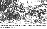
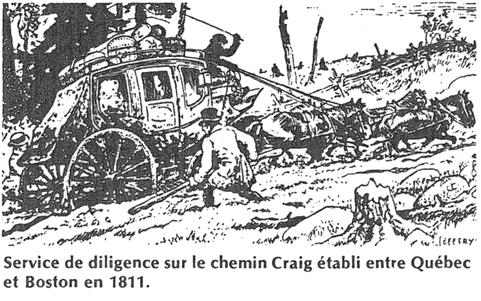
Construction of the road began in August 1810 and took three months. The work force of 180 soldiers cut trees and built bridges to make the road suitable for traffic. Although the terrain was muddy and damaged in several places, it was suitable enough for a winter stagecoach
service, which was established in January 1811 and took passengers from Quebec to Boston in only six days. The service ended at the March thaw and was later abandoned completely because of the difficult traveling conditions, including Lipsey's hill.
The War of 1812
led to the abandonment of the road. Several bridges were destroyed, and the road became overgrown as nature took its toll. Although some repairs were made, the road was declared unfit for passage in 1829. To relieve this problem, the chemin Gosford was built to promote settlement in the area.
The chemin Craig had a mixed success. It opened the territory to new inhabitants, but the results were far from what the planners had desired. Not enough English-speaking settlers arrived, and the goal to assimilate the French Canadians failed. On the contrary, it was the French Canadians who settled the region and became the majority.
In 1983, Quebec writer Madeleine Ferron
published the novel Sur le Chemin Craig, which describes how Irish immigrants settled in the Beauce
region of Quebec during the mid-19th century.
, southwest of Quebec City
. It continues through the town of Saint-Jacques-de-Leeds
and the canton of Inverness
. It then passes near Kinnear's Mills
and through Saint-Jean-de-Brébeuf
and Irlande
. The path from Saint-Gilles to Saint-Ferdinand d'Halifax
corresponds to modern-day Quebec Route 216
. From Saint-Ferdinand, the road continues through Vianney, Chester-Est
, Chesterville
, and Tingwick
. It then passes through Danville
, where it joins Route 116
until Richmond
. The rest of the route past Richmond follows modern-day Route 143
. Heading towards the U.S., it passes through Windsor
, Bromptonville
, Sherbrooke, Ayer's Cliff
and finally Stanstead
at the international border.
James Henry Craig
General Sir James Henry Craig KB was a British military officer and colonial administrator.-Early life and military service:...
, Governor of British North America
Governor General of Canada
The Governor General of Canada is the federal viceregal representative of the Canadian monarch, Queen Elizabeth II...
. It was intended to connect Quebec City
Quebec City
Quebec , also Québec, Quebec City or Québec City is the capital of the Canadian province of Quebec and is located within the Capitale-Nationale region. It is the second most populous city in Quebec after Montreal, which is about to the southwest...
with the United States
United States
The United States of America is a federal constitutional republic comprising fifty states and a federal district...
and to promote settlement of the Eastern Townships
Eastern Townships
The Eastern Townships is a tourist region and a former administrative region in south-eastern Quebec, lying between the former seigneuries south of the Saint Lawrence River and the United States border. Its northern boundary roughly followed Logan's Line, the geologic boundary between the flat,...
.
History
Lower Canada
The Province of Lower Canada was a British colony on the lower Saint Lawrence River and the shores of the Gulf of Saint Lawrence...
, nearly all of the population lived in communities along the St. Lawrence River. The land between the river and the U.S. border had been surveyed and was ready for settlement. In 1810, governor James Henry Craig authorized construction of a road to link Quebec and Boston
Boston
Boston is the capital of and largest city in Massachusetts, and is one of the oldest cities in the United States. The largest city in New England, Boston is regarded as the unofficial "Capital of New England" for its economic and cultural impact on the entire New England region. The city proper had...
in the U.S. He also wanted to promote colonization of the Eastern Townships by anglophones. His ultimate goal was to assimilate the French Canadian
French Canadian
French Canadian or Francophone Canadian, , generally refers to the descendents of French colonists who arrived in New France in the 17th and 18th centuries...
population. The planned route went from Saint-Gilles
Saint-Gilles, Quebec
Saint-Gilles is a parishin the Municipalité régionale de comté de Lotbinière in Quebec, Canada. It is part of the Chaudière-Appalaches region and the population is 1,820 as of 2009. It is named after the seigneurie of Saint-Gilles, of which it was part....
to Richmond
Richmond, Quebec
Richmond, population 3,336 , is a town nestled amidst rolling farmlands on the Saint-François River between Sherbrooke and Drummondville, in the heart of Estrie in Quebec, Canada.-Richmond today:...
, where an existing road (modern-day Quebec Route 143
Quebec route 143
Route 143 is a north/south highway on the south shore of the Saint Lawrence River. Until the mid-1970s when the province decided to renumber all highways other than autoroutes, it was known as Route/Highway 5...
) continued to the American border.
Construction of the road began in August 1810 and took three months. The work force of 180 soldiers cut trees and built bridges to make the road suitable for traffic. Although the terrain was muddy and damaged in several places, it was suitable enough for a winter stagecoach
Stagecoach
A stagecoach is a type of covered wagon for passengers and goods, strongly sprung and drawn by four horses, usually four-in-hand. Widely used before the introduction of railway transport, it made regular trips between stages or stations, which were places of rest provided for stagecoach travelers...
service, which was established in January 1811 and took passengers from Quebec to Boston in only six days. The service ended at the March thaw and was later abandoned completely because of the difficult traveling conditions, including Lipsey's hill.
The War of 1812
War of 1812
The War of 1812 was a military conflict fought between the forces of the United States of America and those of the British Empire. The Americans declared war in 1812 for several reasons, including trade restrictions because of Britain's ongoing war with France, impressment of American merchant...
led to the abandonment of the road. Several bridges were destroyed, and the road became overgrown as nature took its toll. Although some repairs were made, the road was declared unfit for passage in 1829. To relieve this problem, the chemin Gosford was built to promote settlement in the area.
The chemin Craig had a mixed success. It opened the territory to new inhabitants, but the results were far from what the planners had desired. Not enough English-speaking settlers arrived, and the goal to assimilate the French Canadians failed. On the contrary, it was the French Canadians who settled the region and became the majority.
In 1983, Quebec writer Madeleine Ferron
Madeleine Ferron
Madeleine Ferron was a Quebec writer. She was born in Trois-Rivières.She began her early studies with the Sisters of Saint Anne, continuing at the Université de Montréal and Université Laval. She married Robert Cliche, a lawyer, in 1945.A writer and novelist, she also worked as a government...
published the novel Sur le Chemin Craig, which describes how Irish immigrants settled in the Beauce
Beauce, Quebec
Beauce is a historical and traditional region of Quebec located south of Quebec City. It corresponds approximately to the regional county municipalities of Beauce-Sartigan, Robert-Cliche and La Nouvelle-Beauce, and its major communities are Saint-Georges, Sainte-Marie, Beauceville,...
region of Quebec during the mid-19th century.
Route
The chemin Craig begins in Saint-GillesSaint-Gilles, Quebec
Saint-Gilles is a parishin the Municipalité régionale de comté de Lotbinière in Quebec, Canada. It is part of the Chaudière-Appalaches region and the population is 1,820 as of 2009. It is named after the seigneurie of Saint-Gilles, of which it was part....
, southwest of Quebec City
Quebec City
Quebec , also Québec, Quebec City or Québec City is the capital of the Canadian province of Quebec and is located within the Capitale-Nationale region. It is the second most populous city in Quebec after Montreal, which is about to the southwest...
. It continues through the town of Saint-Jacques-de-Leeds
Saint-Jacques-de-Leeds, Quebec
Saint-Jacques-de-Leeds is a municipality located in the Municipalité régionale de comté des Appalaches in Quebec, Canada. It is part of the Chaudière-Appalaches region and the population is 686 as of 2009. It is named after one of Jesus' apostles, James, son of Zebedee, and the city of Leeds,...
and the canton of Inverness
Inverness, Quebec
Inverness is a municipality in the Centre-du-Québec region of the province of Quebec in Canada....
. It then passes near Kinnear's Mills
Kinnear's Mills, Quebec
Kinnear's Mills is a municipality located in the Municipalité régionale de comté des Appalaches in Quebec, Canada. It is part of the Chaudière-Appalaches region and the population is 326 as of 2009. It is known as the "Village of Churches," as four churches are located close to each other in the...
and through Saint-Jean-de-Brébeuf
Saint-Jean-de-Brébeuf, Quebec
Saint-Jean-de-Brébeuf is a municipality in the Municipalité régionale de comté des Appalaches in Quebec, Canada. It is part of the Chaudière-Appalaches region and the population is 397 as of 2009....
and Irlande
Irlande, Quebec
Irlande is a municipality in the Municipalité régionale de comté des Appalaches in Quebec, Canada. It is part of the Chaudière-Appalaches region and the population is 948 as of 2009....
. The path from Saint-Gilles to Saint-Ferdinand d'Halifax
Saint-Ferdinand, Quebec
Saint-Ferdinand is a municipality in the Centre-du-Québec region of the province of Quebec in Canada. It is notable for its location on the shores of Lake William on the Bécancour River, nestled within the Appalachian foothills, making Saint-Ferdinand a popular vacation spot in both summer and...
corresponds to modern-day Quebec Route 216
Quebec route 216
Route 216 is a two-lane east/west highway in Quebec, Canada, which starts in Sainte-Catherine-de-Hatley in the Eastern Townships at the junction of Route 108 and ends in Sainte-Perpétue in Chaudière-Appalaches at the junction of Route 204....
. From Saint-Ferdinand, the road continues through Vianney, Chester-Est
Chester-Est, Quebec
Chester-Est, Quebec is a canton in Centre-du-Québec, Quebec, Canada. Route 263 goes through it.Sainte-Helene de Chester and Trottier Mill are two small towns in this municipality.-Sources:*...
, Chesterville
Chesterville, Quebec
Chesterville is a municipality in the Arthabaska district of the Centre-du-Québec region of Quebec, on Route 161 approximately southeast of Montreal.-Geography:...
, and Tingwick
Tingwick, Quebec
Tingwick is a Canadian municipality of Quebec established in Arthabaska Regional County Municipality, Quebec.-Geography:Municipality of Tingwick is located inside Tingwick township that is part of Eastern Townships. There are 2 rivers: Rivière des Pins and Rivière des Rosiers .-Event:Festival...
. It then passes through Danville
Danville, Quebec
Danville is a town in the administrative region of Estrie, in the Canadian province of Quebec. As of the 2006 Canadian Census, the population was 4,041....
, where it joins Route 116
Quebec route 116
Route 116 is an east/west highway on the south shore of the Saint Lawrence River in Quebec, Canada. Until the 1970s it was known as Route 9. Its eastern terminus is in Lévis at the junction of Route 132, and the western terminus is at the junction of Route 134 in Lemoyne part of a concurrency with...
until Richmond
Richmond, Quebec
Richmond, population 3,336 , is a town nestled amidst rolling farmlands on the Saint-François River between Sherbrooke and Drummondville, in the heart of Estrie in Quebec, Canada.-Richmond today:...
. The rest of the route past Richmond follows modern-day Route 143
Quebec route 143
Route 143 is a north/south highway on the south shore of the Saint Lawrence River. Until the mid-1970s when the province decided to renumber all highways other than autoroutes, it was known as Route/Highway 5...
. Heading towards the U.S., it passes through Windsor
Windsor, Quebec
Windsor is a town of 5,300 people, part of the Le Val-Saint-François Regional County Municipality in the Estrie region of Quebec, Canada, for which it is the seat....
, Bromptonville
Bromptonville, Quebec
Brompton is an arrondissement, or borough, of the city of Sherbrooke, Quebec. The borough comprises the former city of Bromptonville, which was amalgamated into the city of Sherbrooke in 2002....
, Sherbrooke, Ayer's Cliff
Ayer's Cliff, Quebec
Ayer's Cliff is a village on Lake Massawippi, near the mouth of the Tomifobia River, part of the Memphrémagog Regional County Municipality in the Eastern Townships region of Quebec located just north of the Vermont/Canada border....
and finally Stanstead
Stanstead, Quebec
Stanstead is a town of about 3,000 people, part of the Memphrémagog Regional County Municipality in the Estrie region of Québec. Stanstead is located on the Canada-United States border across from Derby Line, Vermont....
at the international border.