
Charwelton railway station
Encyclopedia
Charwelton railway station is a closed station on the former Great Central Railway
main line, the last main line to be built from the North of England to London. The station opened with the line on 15 March 1899 serving the village of Charwelton
in Northamptonshire
.
, and here it was the more common "cutting" type reached from a roadway (the Banbury
to Daventry
road, today's A361
, formerly the B4036), that crossed over the line. Just to the south were Charwelton Watertroughs
, while to the north was Catesby Tunnel, 2,997 yards in length, about 1.7 miles (2.74 km).
In 1917 the Park Gate Iron and Steel Company
, based at Parkgate near Rotherham
, South Yorkshire
, opened an ironstone
quarry
at the nearby village of Hellidon
, and constructed a standard gauge
industrial railway
just over a mile in length to transport the stone to the main line. Production ceased in June 1933 but the Ministry of Supply
ordered its resumpton in May 1941. It ceased once more in October 1945, but was resumed yet again in May 1951. The goods yard at Charwelton was a hive of activity at its peak, with up to 200 wagons stabled in its sidings at any one time. As late as 1961 a new quarry was opened at Hellidon, but this proved less successful and so both quarry and line closed on 18 November that same year, the branch being dismantled in June 1963 and the sidings at Charwelton following in 1964.
Charwelton station closed to passengers and goods on 4 March 1963, the line itself on 5 September 1966. The station buildings had already gone before the line closed, though the platform remained until the mid-1980s as so - more critically - did the road bridge. This became something of a traffic hazard owing to its steep approaches, a sharp kink in the road at the apex on the west side, and poor visibility. In 1985 the bridge was demolished and the road straightened and lowered. The platform was removed at the same time. The road now cuts across the site of the platform roughly level with the "Charwelton" name-sign in the 1909 photograph above right.
Great Central Railway
The Great Central Railway was a railway company in England which came into being when the Manchester, Sheffield and Lincolnshire Railway changed its name in 1897 in anticipation of the opening in 1899 of its London Extension . On 1 January 1923, it was grouped into the London and North Eastern...
main line, the last main line to be built from the North of England to London. The station opened with the line on 15 March 1899 serving the village of Charwelton
Charwelton
Charwelton is a village and civil parish about south of Daventry in Northamptonshire, England. Its toponym is derived from the River Cherwell beside which the village stands....
in Northamptonshire
Northamptonshire
Northamptonshire is a landlocked county in the English East Midlands, with a population of 629,676 as at the 2001 census. It has boundaries with the ceremonial counties of Warwickshire to the west, Leicestershire and Rutland to the north, Cambridgeshire to the east, Bedfordshire to the south-east,...
.
History
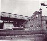
The station was one of the standard island platform design typical of the London ExtensionGreat Central Main Line
The Great Central Main Line , also known as the London Extension of the Manchester, Sheffield and Lincolnshire Railway , is a former railway line which opened in 1899 linking Sheffield with Marylebone Station in London via Nottingham and Leicester.The GCML was the last main line railway built in...
, and here it was the more common "cutting" type reached from a roadway (the Banbury
Banbury
Banbury is a market town and civil parish on the River Cherwell in the Cherwell District of Oxfordshire. It is northwest of London, southeast of Birmingham, south of Coventry and north northwest of the county town of Oxford...
to Daventry
Daventry
Daventry is a market town in Northamptonshire, England, with a population of 22,367 .-Geography:The town is also the administrative centre of the larger Daventry district, which has a population of 71,838. The town is 77 miles north-northwest of London, 13.9 miles west of Northampton and 10.2...
road, today's A361
A361 road
The A361 is a major road in England and at is the longest 3 digit A road in the UK. It runs south from Ilfracombe on the north Devon coast to Barnstaple, turning south-east to Tiverton then, after a break , north east from Taunton in Somerset through Street and Glastonbury, past Frome and then...
, formerly the B4036), that crossed over the line. Just to the south were Charwelton Watertroughs
Track pan
A track pan or water trough is a device to enable a steam railway locomotive to replenish its water supply while in motion...
, while to the north was Catesby Tunnel, 2,997 yards in length, about 1.7 miles (2.74 km).
In 1917 the Park Gate Iron and Steel Company
Park Gate Iron and Steel Company
The Park Gate Iron and Steel Company was situated in Parkgate on a triangular site bounded on two sides by the main Rotherham to Barnsley road and the North Midland Railway's main line between Rotherham and Cudworth Stations.- History :...
, based at Parkgate near Rotherham
Rotherham
Rotherham is a town in South Yorkshire, England. It lies on the River Don, at its confluence with the River Rother, between Sheffield and Doncaster. Rotherham, at from Sheffield City Centre, is surrounded by several smaller settlements, which together form the wider Metropolitan Borough of...
, South Yorkshire
South Yorkshire
South Yorkshire is a metropolitan county in the Yorkshire and the Humber region of England. It has a population of 1.29 million. It consists of four metropolitan boroughs: Barnsley, Doncaster, Rotherham, and City of Sheffield...
, opened an ironstone
Ironstone
Ironstone is a sedimentary rock, either deposited directly as a ferruginous sediment or created by chemical repacement, that contains a substantial proportion of an iron compound from which iron either can be or once was smelted commercially. This term is customarily restricted to hard coarsely...
quarry
Quarry
A quarry is a type of open-pit mine from which rock or minerals are extracted. Quarries are generally used for extracting building materials, such as dimension stone, construction aggregate, riprap, sand, and gravel. They are often collocated with concrete and asphalt plants due to the requirement...
at the nearby village of Hellidon
Hellidon
Hellidon is a village and civil parish in the Daventry district of the county of Northamptonshire in England. According to the 2001 census the parish had a population of 180; it reached its highest population, 449, in 1861....
, and constructed a standard gauge
Standard gauge
The standard gauge is a widely-used track gauge . Approximately 60% of the world's existing railway lines are built to this gauge...
industrial railway
Industrial railway
An industrial railway is a type of railway that is not available for public transportation and is used exclusively to serve a particular industrial, logistics or military site...
just over a mile in length to transport the stone to the main line. Production ceased in June 1933 but the Ministry of Supply
Ministry of Supply
The Ministry of Supply was a department of the UK Government formed in 1939 to co-ordinate the supply of equipment to all three British armed forces, headed by the Minister of Supply. There was, however, a separate ministry responsible for aircraft production and the Admiralty retained...
ordered its resumpton in May 1941. It ceased once more in October 1945, but was resumed yet again in May 1951. The goods yard at Charwelton was a hive of activity at its peak, with up to 200 wagons stabled in its sidings at any one time. As late as 1961 a new quarry was opened at Hellidon, but this proved less successful and so both quarry and line closed on 18 November that same year, the branch being dismantled in June 1963 and the sidings at Charwelton following in 1964.
Charwelton station closed to passengers and goods on 4 March 1963, the line itself on 5 September 1966. The station buildings had already gone before the line closed, though the platform remained until the mid-1980s as so - more critically - did the road bridge. This became something of a traffic hazard owing to its steep approaches, a sharp kink in the road at the apex on the west side, and poor visibility. In 1985 the bridge was demolished and the road straightened and lowered. The platform was removed at the same time. The road now cuts across the site of the platform roughly level with the "Charwelton" name-sign in the 1909 photograph above right.