
Chapadão do Céu
Encyclopedia
| Chapadão do Céu | |
|---|---|
| State | Goiás Goiás Goiás is a state of Brazil, located in the central part of the country. The name Goiás comes from the name of an indigenous community... |
| Area: | 2,354.8 km² |
| Population: | 5,289(IBGE 2007) |
| Population density | 2.25 inhab/km² |
| Urban population | 4,355 |
| Rural population | 934 |
| Elevation: | 840m |
| Postcode (CEP): | 75828-000 |
| IBGE statistical microregion: | 018 Sudoeste de Goiás Microregion |
| Became a city: | 1993 |
| Mayor: | Eduardo Pagnocelli Peixoto |
| Distance to Goiânia Goiânia -Climate:The city has a tropical wet and dry climate with an average temperature of . There's a wet season, from October to April, and a dry one, from May to September. Annual rainfall is around 1,520 mm.... : |
467 km. |
| Website: | Municipio de Chapadão do Céu |

Town
A town is a human settlement larger than a village but smaller than a city. The size a settlement must be in order to be called a "town" varies considerably in different parts of the world, so that, for example, many American "small towns" seem to British people to be no more than villages, while...
and municipality
Municipality
A municipality is essentially an urban administrative division having corporate status and usually powers of self-government. It can also be used to mean the governing body of a municipality. A municipality is a general-purpose administrative subdivision, as opposed to a special-purpose district...
in southwestern Goiás
Goiás
Goiás is a state of Brazil, located in the central part of the country. The name Goiás comes from the name of an indigenous community...
state, Brazil
Brazil
Brazil , officially the Federative Republic of Brazil , is the largest country in South America. It is the world's fifth largest country, both by geographical area and by population with over 192 million people...
. It is a large producer of grains (soybeans and corn) and has a high standard of living.
Geographical Information
It is located on the dividing line between the states of Mato Grosso do SulMato Grosso do Sul
Mato Grosso do Sul is one of the states of Brazil.Neighboring Brazilian states are Mato Grosso, Goiás, Minas Gerais, São Paulo and Paraná. It also borders the countries of Paraguay and Bolivia to the west. The economy of the state is largely based on agriculture and cattle-raising...
and Goiás
Goiás
Goiás is a state of Brazil, located in the central part of the country. The name Goiás comes from the name of an indigenous community...
. The distance to the state capital, Goiânia
Goiânia
-Climate:The city has a tropical wet and dry climate with an average temperature of . There's a wet season, from October to April, and a dry one, from May to September. Annual rainfall is around 1,520 mm....
, is 467 km. Connecting highways are BR-060 / Guapó
Guapó
Guapó is a small town and municipality in central Goiás state, Brazil. The population was 13,586 and the total area of the municipality was 517.0 km² .Guapó is part of the Goiânia Microregion...
/ Cezarina
Cezarina
Cezarina is a municipality in central Goiás state, Brazil.-Location and Communications:Cezarina belongs to the Vale do Rio dos Bois statistical micro-region. It has municipal boundaries with:*north: Palmeiras de Goiás*south: Edealina*east: Varjão...
/ Indiara
Indiara
Indiara is a small city and municipality in central-south Goiás state, Brazil. Indiara is a large producer of soybeans and cotton.-Location:Indiara is located in the Vale do Rio dos Bois and has municipal boundaries with:*north: Palmeiras de Goiás...
/ Acreúna
Acreúna
Acreúna is a small city and municipality in western Goiás state, Brazil.-Location:Acreúna is located in the statistical micro-region of Vale do Rio dos Bois, southwest of the state capital, Goiânia, on BR-060, which links Goiânia with Rio Verde...
/ Rio Verde
Rio Verde, Goiás
Rio Verde is a city and municipality in the Brazilian state of Goiás. It is a fast-growing center and is the largest producer of grains in the state.-Location:...
/ Jataí
Jataí
Jataí is a municipality in southern Goiás state, Brazil. Its population was 88,048 in a total area of 7,174.2 km². Jataí is a major producer of agricultural products, including soybeans, rice, and corn. It has the largest herd of cattle in the state and is a large producer of poultry and...
/ GO-050 (40 km unpaved road). Distances to other towns are: 50 km. to Chapadão do Sul
Chapadão do Sul
Chapadão do Sul is a municipality located in the Brazilian state of Mato Grosso do Sul. Its population was 15,425 and its area is 3,851 km²....
; 109 km. to Mineiros
Mineiros
Mineiros is a city in the southwest of the state of Goiás, Brazil. Mineiros is the westernmost city in Goiás and a great producer of cattle, soybeans, and corn....
; 106 km. to Jataí
Jataí
Jataí is a municipality in southern Goiás state, Brazil. Its population was 88,048 in a total area of 7,174.2 km². Jataí is a major producer of agricultural products, including soybeans, rice, and corn. It has the largest herd of cattle in the state and is a large producer of poultry and...
; 255 km. to Rio Verde
Rio Verde, Goiás
Rio Verde is a city and municipality in the Brazilian state of Goiás. It is a fast-growing center and is the largest producer of grains in the state.-Location:...
; and 451 km. to Itumbiara
Itumbiara
Itumbiara is a small city and municipality in the extreme south of the state of Goiás, Brazil. The population was 100,000 in a total area of 2,461,3 km²...
.
Municipal boundaries are with:
- North: SerranópolisSerranópolisSerranópolis is a small town and municipality in southeast Goiás state, Brazil. It is one of the largest municipalities in the state in area and one of the most sparsely inhabited. It is a large producer of cattle and soybeans.-Location:...
and MineirosMineirosMineiros is a city in the southwest of the state of Goiás, Brazil. Mineiros is the westernmost city in Goiás and a great producer of cattle, soybeans, and corn....
; - West: MineirosMineirosMineiros is a city in the southwest of the state of Goiás, Brazil. Mineiros is the westernmost city in Goiás and a great producer of cattle, soybeans, and corn....
and Costa RicaCosta RicaCosta Rica , officially the Republic of Costa Rica is a multilingual, multiethnic and multicultural country in Central America, bordered by Nicaragua to the north, Panama to the southeast, the Pacific Ocean to the west and the Caribbean Sea to the east....
(MS); - South: Chapadão do SulChapadão do SulChapadão do Sul is a municipality located in the Brazilian state of Mato Grosso do Sul. Its population was 15,425 and its area is 3,851 km²....
(MS); - East: AporéAporéAporé is a small town and municipality in southwest Goiás state, Brazil. The municipality is a large producer of cattle. Aporé belongs to the Southwest Goiás Microregion.-Geography:...
.
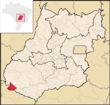
For a map see Chapadaodoceu
Demographic and Political Data
- Population growth rate 1996/2000: 9.48%
- Population growth rate 2000/2007: 4.92%
- Mayor (Prefeito)--Eduardo Pagnocelli Peixoto
- Vice-mayor (Vice-Prefeito)--Paulo Rodrigues da Cunha
- City council (Vereadores): 09
Economy
Despite the low fertility of the soil, the region has agricultural potential because of the flat land and abundance of water. There are plantations of soybeans, corn, and rice, which show good averages of productivity after soil correction, modern techniques, and the use of advanced machines and equipment are applied. In 2006 there were 126 agricultural installations with 56,140 hectares of planted area. Only 36 of these farms had cattle. Forty five of the farms had tractors.Economic Activity
- Industrial units: 08 (2007)
- Retail units: 113
- Financial institutions: Banco do Brasil S.A.
Agricultural Production (2006)
- cattle: 19,000 head
- cotton: 6,945 hectares
- corn: 33,911 hectares
- soybeans: 101,946 hectares
- sorghum: 20,000 hectares
Data are from 2006 and can be found at IBGE
Best quality of life in Goiás
Chapadão is becoming one of the state's biggest producers of soybeans and corn. It was also singled out in 2003 as having the highest ranking in the state of GoiásGoiás
Goiás is a state of Brazil, located in the central part of the country. The name Goiás comes from the name of an indigenous community...
on the United Nation's Human Development Index.chapadaodoceu The index was 0.834, ranking Chapadão 1 out of 242 municipalities in Goiás and 100 out of 5,507 municipalities in the country. All the water in the town is treated, all the children go to public school, and there is almost zero infant mortality. See Human Development Index
Human Development Index
The Human Development Index is a composite statistic used to rank countries by level of "human development" and separate "very high human development", "high human development", "medium human development", and "low human development" countries...
Education and Health
- Literacy rate in 2000: 95.1% (the highest in the state)
- Schools: 07 (2006) with 1,987 students
- Infant mortality rate in 2000: 11.36 in 1,000 live births
- Hospitals: 01 with 14 beds (2007)
- Public health clinics: 04
Climate and Tourism
Chapadão do Céu has about 32% of its total area in reserves, including the Parque Nacional das Emas, legal reserves (20% of rural properties) and permanent reserves (river banks, streams, and springs).The climate is moist tropical with an average annual temperature between 19°C and 37°C. The relative air humidity is around 55%.
The region is watered by the following rivers: Água Amarela, Aporé, Corrente, Formoso, Jacuba, Prata, Pratinha and Sucuriú. The municipality is the gateway to the largest preserved area of the cerrado
Cerrado
The Cerrado, is a vast tropical savanna ecoregion of Brazil, particularly in the states of Gioas and Minas Gerais...
bioma in the world: the Parque Nacional das Emas, with its rich variety of flowers, plants, animals, birds, and beautiful landscapes.