

Cedar Creek (Indiana)
Encyclopedia
Tributary
A tributary or affluent is a stream or river that flows into a main stem river or a lake. A tributary does not flow directly into a sea or ocean...
of the St. Joseph River
St. Joseph River (Maumee River)
The St. Joseph River is an tributary of the Maumee River in northwestern Ohio, and northeastern Indiana in the United States, with headwater tributaries rising in southern Michigan. It drains a primarily rural farming region in the watershed of Lake Erie. It shares its name with the St...
, draining 174780 acre in northeastern Indiana
Indiana
Indiana is a US state, admitted to the United States as the 19th on December 11, 1816. It is located in the Midwestern United States and Great Lakes Region. With 6,483,802 residents, the state is ranked 15th in population and 16th in population density. Indiana is ranked 38th in land area and is...
. It is 31.9 miles (51.3 km) long, rising in northwestern DeKalb County
DeKalb County, Indiana
DeKalb County is a county located in the U.S. state of Indiana. Named for Revolutionary War hero Johann, Baron de Kalb , the county was created by the Indiana legislature in 1835 and organized in 1837. As of 2010, the population was 42,223...
and joining the St. Joseph just below the Cedarville Dam
Leo-Cedarville, Indiana
Leo-Cedarville is a town in Cedar Creek Township, Allen County, Indiana, United States. The population was 3,603 at the 2010 census.-History:Leo-Cedarville was formed by the incorporation of the villages of Leo and Cedarville in the mid-1990s...
in Allen County
Allen County, Indiana
As of the census of 2000, there were 331,849 people, 128,745 households, and 86,259 families residing in the county. The population density was 505 people per square mile . There were 138,905 housing units at an average density of 211 per square mile...
.
Origins and history
Upper Cedar Creek originated as an ice-marginal channel at the western edge of the Erie Lobe of the Wisconsin Glacier and formed a single stream with the southwest-flowing Eel River which connected to the Wabash RiverWabash River
The Wabash River is a river in the Midwestern United States that flows southwest from northwest Ohio near Fort Recovery across northern Indiana to southern Illinois, where it forms the Illinois-Indiana border before draining into the Ohio River, of which it is the largest northern tributary...
. Lower Cedar Creek was a tributary
Tributary
A tributary or affluent is a stream or river that flows into a main stem river or a lake. A tributary does not flow directly into a sea or ocean...
of the ancestral Eel, carrying glacial meltwater under the ice through a tunnel valley
Tunnel valley
A tunnel valley is a large, long, U-shaped valley originally cut under the glacial ice near the margin of continental ice sheets such as that now covering Antarctica and formerly covering portions of all continents during past glacial ages....
known today as Cedar Creek Canyon
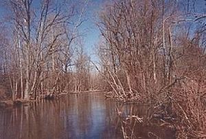
Cedar Creek Canyon (Indiana)
Cedar Creek Canyon, also called simply Cedar Canyon, is a topographical feature located in Allen County, Indiana. It is a very straight, narrow gorge about deep that contains part of the lower segment of Cedar Creek, the largest tributary of the St. Joseph River...
. Blockage of the Eel's channel
Channel (geography)
In physical geography, a channel is the physical confine of a river, slough or ocean strait consisting of a bed and banks.A channel is also the natural or human-made deeper course through a reef, sand bar, bay, or any shallow body of water...
by outwash
Outwash fan
An outwash fan is a fan-shaped body of sediments deposited by braided streams from a melting glacier. Sediment locked within the ice of the glacier, gets transported by the streams of meltwater, and deposits on the outwash plain, at the terminus of the glacier...
from the canyon and a decline in the volume of meltwater caused lower Cedar Creek to reverse its flow. In so doing, it captured the flow of the upper Eel, a classic example of stream piracy that shifted Cedar Creek's drainage (about 175,000 acres) from the Eel-Wabash system to that of the St. Joseph-Maumee
Maumee River
The Maumee River is a river in northwestern Ohio and northeastern Indiana in the United States. It is formed at Fort Wayne, Indiana by the confluence of the St. Joseph and St. Marys rivers, and meanders northeastwardly for through an agricultural region of glacial moraines before flowing into the...
.
Once a meander
Meander
A meander in general is a bend in a sinuous watercourse. A meander is formed when the moving water in a stream erodes the outer banks and widens its valley. A stream of any volume may assume a meandering course, alternately eroding sediments from the outside of a bend and depositing them on the...
ing stream, upper Cedar Creek was channelized (straightened and deepened) in the early 20th century for agricultural and urban drainage, which has increased the watershed
Drainage basin
A drainage basin is an extent or an area of land where surface water from rain and melting snow or ice converges to a single point, usually the exit of the basin, where the waters join another waterbody, such as a river, lake, reservoir, estuary, wetland, sea, or ocean...
's vulnerability to erosion and contaminated runoff. Once home to 27 species of freshwater mussel
Mussel
The common name mussel is used for members of several families of clams or bivalvia mollusca, from saltwater and freshwater habitats. These groups have in common a shell whose outline is elongated and asymmetrical compared with other edible clams, which are often more or less rounded or oval.The...
, Cedar Creek has experienced a drastic decline in mussel population since the 1980s.
Course
Cedar Creek originates at Indian Lake (41º27'51" N 85º10'11" W), northwest of Corunna, IndianaCorunna, Indiana
Corunna is a town in Richland Township, DeKalb County, Indiana, United States. The population was 251 at the 2010 census.-Geography:The Corunna Town Hall is located at 102 N Bridge St.. This Building is also the former home to the Corunna Volunteer Fire Department The Corunna Volunteer Fire...
, and comes into formal existence downstream at Cedar Lake. Its DeKalb County
DeKalb County, Indiana
DeKalb County is a county located in the U.S. state of Indiana. Named for Revolutionary War hero Johann, Baron de Kalb , the county was created by the Indiana legislature in 1835 and organized in 1837. As of 2010, the population was 42,223...
section flows east-southeast from Indian Lake, loops around Waterloo
Waterloo, Indiana
Waterloo is a town in Grant and Smithfield townships, DeKalb County, Indiana, United States. The population was 2,242 at the 2010 census.-Geography:Waterloo is located at ....
, passes through Auburn
Auburn, Indiana
Auburn is a city in DeKalb County, Indiana, United States. The population was 13,086 at the 2010 census. Founded in 1836 by Wesley Park , the city is the county seat of DeKalb County. Auburn is also known as Home of the Classics.-Geography:...
, then angles southwest until it enters Allen County, where it is crossed by Indiana State Road 327
Indiana State Road 327
Indiana State Road 327 is a north–south, largely rural surface highway in north-eastern Indiana.-Route description:State Road 327 is an undivided surface road throughout its entire course between the Indiana/Michigan state line just north of Orland, Indiana to a point just south of Garrett,...
south of Garrett
Garrett, Indiana
Garrett is a city in Keyser Township, DeKalb County, Indiana, United States. The population was 6,286 at the 2010 census. Founded in 1875, Garrett was named for John W...
before turning back to the southeast toward Leo-Cedarville
Leo-Cedarville, Indiana
Leo-Cedarville is a town in Cedar Creek Township, Allen County, Indiana, United States. The population was 3,603 at the 2010 census.-History:Leo-Cedarville was formed by the incorporation of the villages of Leo and Cedarville in the mid-1990s...
.
Lower Cedar Creek, from river mile
River mile
In the United States, a River mile is a measure of distance in miles along a river from its mouth. River mile numbers begin at zero and increase further upstream. The corresponding metric unit using kilometers is the River kilometer...
13.7 to its confluence
Confluence (geography)
In geography, a confluence is the meeting of two or more bodies of water. It usually refers to the point where two streams flow together, merging into a single stream...
with the St. Joseph, is officially designated as an "Outstanding State Resource Water" and is one of four streams in Indiana's Natural, Scenic and Recreational Rivers system.
Tributaries
- (left) Willow Creek
- (left) Kell Ditch
- (left) Willow Creek Ditch
- (left) Willow Creek Branch
- (right) Hatch Ditch
- (right) Krumlauf Branch
- (left) Yant Ditch
- White Lake
- Wappes Ditch
- (left) Clark Chapman Ditch
- Fulk Lake
- White Lake
- (left) Little Cedar Creek
- (left) Black Creek
- (left) Bilger Ditch
- (right) Whan Ditch
- Roudy Lake
- Mud Lake
- (left) Bilger Ditch
- (left) Hinkley Ditch
- (left) outflow from King Lake
- (left) Yarde Ditch
- (left) Sycamore Creek
- (left) Black Creek
- (right) Schmadel Ditch
- (right) Dosch Ditch
- (left) Garrett City Ditch
- (left) Diehl Ditch
- (right) Peckhart Ditch
- (left) Ober Ditch
- (right) Peckhart Ditch
- (right) W Smith Ditch
- (right) Matson Ditch
- (left) Swartz Ditch
- (right) Dibbling Ditch
- Cedar Lake
- Leins Ditch
- (left) McCullough Ditch
- Indian Lake
- Leins Ditch
External links
- Topographic map from TopoQuest: Cedar Creek headwaters at Indian Lake
- Topographic map from TopoQuest: Cedar Creek headwaters at Cedar Lake
- Topographic map from TopoQuest: Cedar Creek confluence with St. Joseph River
- National Weather Service: Current Hydrologic Data for Cedar Creek at Auburn
- National Weather Service: Current Hydrologic Data for Cedar Creek near Leo-Cedarville
- Cedar Creek Wildlife Project
- St. Joseph River Watershed Initiative
- Maumee River Basin Commission
- Abstract: M. Larose et al., "Hydrologic and Atrazine Simulation of the Cedar Creek Watershed Using the SWAT Model," Journal of Environmental Quality, 36:521-531 (2007).