

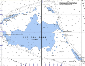
Cay Sal Bank
Encyclopedia

Bahama Banks
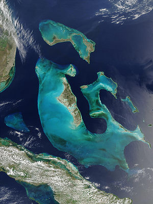
The Bahama Banks are the submerged carbonate platforms that make up much of the Bahama Archipelago. The term is usually applied in referring to either the Great Bahama Bank around Andros Island, or the Little Bahama Bank of Grand Bahama Island and Great Abaco, which are the largest of the...
. It is located between 23º27'N - 24º10'N and 079º25'W – 080º35'W. In a geographical sense, it is separate from the Bahamas proper as it is much closer to Cuba
Cuba
The Republic of Cuba is an island nation in the Caribbean. The nation of Cuba consists of the main island of Cuba, the Isla de la Juventud, and several archipelagos. Havana is the largest city in Cuba and the country's capital. Santiago de Cuba is the second largest city...
(from which it is separated by Nicholas Channel
Nicholas Channel
Nicholas Channel is a strait off the northwestern coast of Cuba. It lies east of Havana. It separates Cuba from the most southwestern of the islands of the Bahamas....
, at a distance of 50 km) than to the closest Bahamanian island. It is separated by Santaren Channel from the Great Bahama Bank, the western rim of which is 50 km to the east. The westernmost tip of Andros
Andros, Bahamas
Andros Island is an archipelago within the archipelago-nation of the Bahamas, the largest of the 26 inhabited Bahamian Islands. Geo-politically considered a single island, Andros has an area greater than all the other 700 Bahamian islands combined...
, the next closest islands of the Bahamas, is 145 km east of Cay Sal Bank. The Straits of Florida
Straits of Florida
The Straits of Florida, Florida Straits, or Florida Strait is a strait located south-southeast of the North American mainland, generally accepted to be between the Gulf of Mexico and the Atlantic Ocean, and between the Florida Keys and Cuba. The strait carries the Florida Current, the beginning of...
separate it from the United States
United States
The United States of America is a federal constitutional republic comprising fifty states and a federal district...
mainland and the Florida Keys
Florida Keys
The Florida Keys are a coral archipelago in southeast United States. They begin at the southeastern tip of the Florida peninsula, about south of Miami, and extend in a gentle arc south-southwest and then westward to Key West, the westernmost of the inhabited islands, and on to the uninhabited Dry...
(Key Largo
Key Largo
Key Largo is an island in the upper Florida Keys archipelago and, at long, the largest of the Keys. It is also the northernmost of the Florida Keys in Monroe County, and the northernmost of the Keys connected by U.S. Highway 1...
is 100 km to the north).
Administratively, the bank and its islands are part of Bimini
Bimini
Bimini is the westernmost district of the Bahamas composed of a chain of islands located about 53 miles due east of Miami, Florida. Bimini is the closest point in the Bahamas to the mainland United States and approximately 137 miles west-northwest of Nassau...
district, the main islands of which are 150 km to the north.
Cay Sal Bank is an atoll
Atoll
An atoll is a coral island that encircles a lagoon partially or completely.- Usage :The word atoll comes from the Dhivehi word atholhu OED...
of roughly triangular shape, with a base along the south rim of 105 km, and a width of 66 km north-south, with islets along its rim, except along the south side facing Nicholas Channel, where it has only numerous rocky coral heads. As such, it is one of the largest atolls of the world. Among the atolls with some land area (i.e. disregarding totally submerged atoll structures), Cay Sal Bank, with a total area of 5,226.73 km², is second only to Great Chagos Bank
Great Chagos Bank
The Great Chagos Bank, in the Chagos Archipelago, about South of the Maldives, is the largest atoll structure in the world, with a total area of . The Atoll is administered by the UK through the BIOT.-Islands:...
, while the land area measures only 14,87 km². The lagoon
Lagoon
A lagoon is a body of shallow sea water or brackish water separated from the sea by some form of barrier. The EU's habitat directive defines lagoons as "expanses of shallow coastal salt water, of varying salinity or water volume, wholly or partially separated from the sea by sand banks or shingle,...
al surface has a depth of 9 to 16 meters. The individual islands (i.e. islets or cays) are 96 in number http://www.qslnet.de/member/na219/QTH.htm.
The islands, rocks and reefs along the rim of the atoll are listed clockwise from southwest to southeast:
- Lavenderas (Lavanderas) Rocks, 23°42′N 80°21′W, 2.5 km east of Cay Sal (submerged)
- Cay Sal, 23°42′N 80°24′W
- Rompidas Ledge, 23°46′N 80°27′W (submerged)
- Elbow Cays, 23°46′N 80°27′W
- Crenula Cay
- Double Headed Shot Cays, 23°56′N 80°28′W
- Water Cays (West Water Cay and East Water Cay), 24°00′N 80°15′W
- Marion Rock, 24°01′30"N 80°20′30"W (submerged)
- Deadman's Cays, 24°02′N 80°11′W
- Muertos Cays, 24°01′N 80°05′W
- Dog Rocks, 24°05′N 79°51′W (northernmost, at the northeast corner)
- Damas Cays, 23°53′01"N 79°48′30"W
- North Dangerous Shoals (North Dangerous Rocks), 23°45′N 79°43′W
- South Dangerous Rock (submerged?)
- Bellows Cay
- Anguilla Cays, 23°30′01"N 79°32′30"W
Cay Sal, the main island in the southwest at 23°42′N 80°25′W, is 1.6 km long, 1.22 km² in area, and is the only inhabited island of Cay Sal Bank. In its interior is a large salt pond commonly replenished by heavy wind-driven seas that broach the islet along its southwest side. It is covered with stunted palm trees and marked by several buildings standing on its west side.
Rompidas Ledge is a submerged coral head 3 km northwest of Cay Sal, about 1 km² in extension and only 6 meters deep. The cargo ship M/V Cork ran aground there in 1983, and position is marked by its wreck.
The Elbow Cays contain are the westernmost group, running southeast to northwest. North Elbow Cay, the largest and highest of the cays, is marked by a disused conical stone lighthouse, which is 17.7 m high. South Elbow cay is the westernmost named cay of Cay Sal Bank. Further southwest are a few unnamed cays and rocks.
The Double Headed Shot Cays extend as a group of elongated islets from South Elbow Cay in the southwest, to the Water Cays in the northeast, and are in a position on the northwest side of Cay Sal Bank where the Florida Current, in its course east and north through the Straits of Florida, usually sets close offshore at full strength.
Anguilla Cays, near the southeast extremity of Cal Say Bank, consist of several elongated, scrub-covered, sandy islands which are swampy near their southern end, and are marked here and there by stunted palm trees. The northern end of Anguilla Cays is marked by a beacon, 5 m high. Anguilla Cay is the name of the northern and second largest of the Anguilla Cays. Cotton Cay, the southern Anguilla Cay, is the largest and southernmost of the Anguilla Cays. Between the two is the much smaller Middle Cay. There are also a number of smaller, unnamed cays or rocks.