

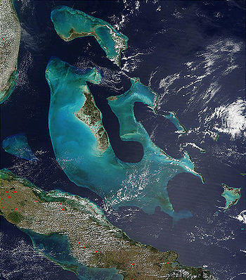
Bahama Banks
Encyclopedia
Carbonate platform
A carbonate platform is a sedimentary body which possesses topographic relief, and is composed of autochthonous calcareous deposits . Platform growth is mediated by sessile organisms whose skeletons build up the reef or by organisms which induce carbonate precipitation through their metabolism...
s that make up much of the Bahama Archipelago. The term is usually applied in referring to either the Great Bahama Bank around Andros Island, or the Little Bahama Bank of Grand Bahama
Grand Bahama
Grand Bahama is one of the northernmost of the islands of the Bahamas, and the closest major island to the United States, lying off the state of Florida. Grand Bahama is the fifth largest island in the Bahamas island chain of approximately 700 islands and 2,400 cays...
Island and Great Abaco, which are the largest of the platforms, and the Cay Sal Bank
Cay Sal Bank
Cay Sal Bank is the third largest and the westernmost of the Bahama Banks. It is located between 23º27'N - 24º10'N and 079º25'W – 080º35'W...
north of Cuba
Cuba
The Republic of Cuba is an island nation in the Caribbean. The nation of Cuba consists of the main island of Cuba, the Isla de la Juventud, and several archipelagos. Havana is the largest city in Cuba and the country's capital. Santiago de Cuba is the second largest city...
. The islands of these banks are politically part of the Bahamas. Other banks are the three banks of the Turks and Caicos Islands
Turks and Caicos Islands
The Turks and Caicos Islands are a British Overseas Territory and overseas territory of the European Union consisting of two groups of tropical islands in the Caribbean, the larger Caicos Islands and the smaller Turks Islands, known for tourism and as an offshore financial centre.The Turks and...
, namely the Caicos Bank of the Caicos Islands, the bank of the Turks Islands, and wholly submerged Mouchoir Bank
Mouchoir Bank
Mouchoir Bank, in Spanish also called Banco de Pañuelo Blanco is located southeast of the Turks islands and is geographically a continuation of the Bahamas. It is part of the Turks and Caicos Islands and falls within its EEZ. Much of its north side is awash in two groupings of coral reef. A 1.8 m...
. Further southeast are the equally wholly submerged Silver Bank
Silver Bank
Silver Bank is an area in the Atlantic Ocean north of the Dominican Republic and southeast of the Territory of Turks & Caicos. It covers an area of 1680 km² . It is separated from Mouchoir Bank in the west by Silver Bank Passage, and from Navidad Bank in the east by Navidad Bank Passage...
and Navidad Bank
Navidad Bank
Navidad Bank is an area in the Atlantic Ocean north of the Dominican Republic and southeast of the Territory of Turks & Caicos. It is separated from Silver Bank by the wide Navidad Bank Passage. It is a shallow underwater area composed of coral and sand that almost reaches the ocean's surface, but...
north of the Dominican Republic
Dominican Republic
The Dominican Republic is a nation on the island of La Hispaniola, part of the Greater Antilles archipelago in the Caribbean region. The western third of the island is occupied by the nation of Haiti, making Hispaniola one of two Caribbean islands that are shared by two countries...
.
Geologic history and structure
The limestoneLimestone
Limestone is a sedimentary rock composed largely of the minerals calcite and aragonite, which are different crystal forms of calcium carbonate . Many limestones are composed from skeletal fragments of marine organisms such as coral or foraminifera....
that comprises the Banks has been accumulating since at least the Cretaceous
Cretaceous
The Cretaceous , derived from the Latin "creta" , usually abbreviated K for its German translation Kreide , is a geologic period and system from circa to million years ago. In the geologic timescale, the Cretaceous follows the Jurassic period and is followed by the Paleogene period of the...
period, and perhaps as early as the Jurassic
Jurassic
The Jurassic is a geologic period and system that extends from about Mya to Mya, that is, from the end of the Triassic to the beginning of the Cretaceous. The Jurassic constitutes the middle period of the Mesozoic era, also known as the age of reptiles. The start of the period is marked by...
; today the total thickness under the Great Bahama Bank is over 4500 meters. As its limestones were deposited in shallow water, the only way to explain this massive column is to estimate that the entire platform has subsided under its own weight at a rate of roughly 3.6 centimeters per 1,000 years.
The waters of the Bahama Banks are very shallow; on the Great Bahama Bank they are generally no deeper than 25 meters.
The slopes around them however, such as the border of the Tongue of the Ocean
Tongue of the Ocean
The Tongue of the Ocean is the name of a deep oceanic trench in the Bahamas separating the islands of Andros and New Providence. The depth of the water drops from roughly along Andros' east offshore barrier reef to over , and the drop is roughly long....
in the Great Bahama Bank, are very steep. The Banks were dry land during past ice age
Ice age
An ice age or, more precisely, glacial age, is a generic geological period of long-term reduction in the temperature of the Earth's surface and atmosphere, resulting in the presence or expansion of continental ice sheets, polar ice sheets and alpine glaciers...
s, when sea level was as much as 120 meters lower than at present; the area of the Bahamas today thus represents only a small fraction of their prehistoric extent. When they were exposed to the atmosphere
Atmosphere
An atmosphere is a layer of gases that may surround a material body of sufficient mass, and that is held in place by the gravity of the body. An atmosphere may be retained for a longer duration, if the gravity is high and the atmosphere's temperature is low...
, their limestones were subjected to chemical weathering that created the caves and sinkholes common to karst
KARST
Kilometer-square Area Radio Synthesis Telescope is a Chinese telescope project to which FAST is a forerunner. KARST is a set of large spherical reflectors on karst landforms, which are bowlshaped limestone sinkholes named after the Kras region in Slovenia and Northern Italy. It will consist of...
terrain, resulting in structures like blue hole
Blue hole
A blue hole is a cave or underwater sinkhole. They are also called vertical caves. There are many different blue holes located around the world, typically in low-lying coastal regions...
s.
See also
- Ocean bank (topography)
- Geography of the BahamasGeography of the BahamasThe Bahamas is a group of about 700 atolls and cays in the western Atlantic Ocean, of which only between 30 and 40 are inhabited. The largest of the islands is Andros Island, located southeast of Florida. The Bimini islands are to its northwest. To the North is the island of Grand Bahama, home to...
- Dean's Blue HoleDean's Blue HoleDean's Blue Hole is the world's deepest known blue hole with seawater. It plunges in a bay west of Clarence Town on Long Island, Bahamas.-History:The full depth of the cave was reached by Jim King in 1992....
- Carbonate platformCarbonate platformA carbonate platform is a sedimentary body which possesses topographic relief, and is composed of autochthonous calcareous deposits . Platform growth is mediated by sessile organisms whose skeletons build up the reef or by organisms which induce carbonate precipitation through their metabolism...