

Great Chagos Bank
Encyclopedia
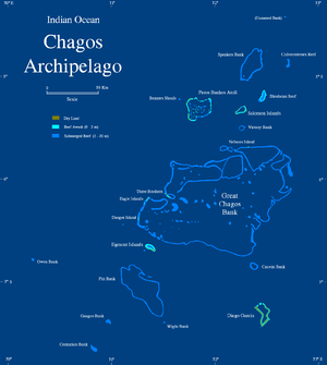
Chagos Archipelago
The Chagos Archipelago , is a group of seven atolls comprising more than 60 individual tropical islands in the Indian Ocean; situated some due south of the Maldives archipelago. This chain of islands are the southernmost archipelago of the Chagos-Laccadive Ridge a long submarine mountain range...
, about 500 km (310.7 mi) South of the Maldives
Maldives
The Maldives , , officially Republic of Maldives , also referred to as the Maldive Islands, is an island nation in the Indian Ocean formed by a double chain of twenty-six atolls oriented north-south off India's Lakshadweep islands, between Minicoy Island and...
, is the largest atoll
Atoll
An atoll is a coral island that encircles a lagoon partially or completely.- Usage :The word atoll comes from the Dhivehi word atholhu OED...
structure in the world, with a total area of 12642 km² (4,881.1 sq mi). The Atoll is administered by the UK through the BIOT
Biot
Biot or BIOT may refer to:* Biot, Alpes-Maritimes, a commune in France* Biot , a lunar crater* British Indian Ocean Territory* Camille Biot , French physician...
.
Islands
Despite its enormous size, the Great Chagos Bank is largely a submarine structure. There are only four emerging reefs, mostly located on the eastern rim of the atoll, except for lonely Nelson Island which lies wholly isolated in the middle of the northern fringe. These reefs have seven or eight individual low and sandy islands, with a total land area of about 4.5 km² (1.7 sq mi). All islands and their surrounding waters are a Strict Nature Reserve since 1998. The total length of the eastern and southern expanses of the bank, as well as the reefs in its central area are wholly submerged.The islands of the Great Chagos Bank, starting clockwise from the south, are:
- Danger IslandDanger IslandDanger Island is the westernmost and the southernmost island of the Great Chagos Bank, which is the world's largest coral atoll structure, located in the Chagos Archipelago.-Description:...
(slightly more than 2 km (1.2 mi) long from North to South, by 1 km (0.621372736649807 mi) wide, land area 0.66 km² (0.254827424671073 sq mi), vegetated with palmArecaceaeArecaceae or Palmae , are a family of flowering plants, the only family in the monocot order Arecales. There are roughly 202 currently known genera with around 2600 species, most of which are restricted to tropical, subtropical, and warm temperate climates...
trees up to 12 m (39.4 ft) high. - Eagle IslandsEagle IslandsEagle Islands is a group of two islands in the Chagos Archipelago. They are located on the central-western rim of the Great Chagos Bank, which is the world's largest coral atoll structure.-Islands:...
- Île Aigle (Eagle Island, vegetated with high coconut trees, land area 2.45 km² (0.945950288551711 sq mi)
- Sea Cow Island (Île Vache Marine), vegetated with trees, land area 18 hectares (44.5 acre).
- Three BrothersThree Brothers (islands)The Three Brothers are a group of three small coral islands 20 km East of Eagle Islands along the central western rim of the Great Chagos Bank, which is the world's largest coral atoll structure, located in the Chagos Archipelago.-Islands:...
(Trois Fréres) and Resurgent Islands, vegetated with high coconut trees, land area 0.4 km² (0.154440863437014 sq mi).- Île du Sud (South Island, largest of the group), 23 ha (56.8 acre)
- Île du Milieu (Middle Island), 8 ha (19.8 acre)
- unnamed rocky islet
- Île du Nord (North Island), 6 ha (14.8 acre)
- Nelson IslandNelsons IslandNelson Island or Nelsons Island is the northernmost and the easternmost island of the Great Chagos Bank, which is the world's largest coral atoll structure, located in the Chagos Archipelago in the Indian Ocean. The nearest neighbour is Île Boddam in the Salomon Islands.Nelson Island occupies the...
(2 km (1.2 mi) long from East to West, up to 0.41 km (0.254762822026421 mi) wide, land area 0.4 km² (0.154440863437014 sq mi), with 3 m (9.8 ft) high, bushy vegetation.
Cartography of the Submerged Reefs
The Great Chagos bank was surveyed for the first time by Commander Robert MoresbyRobert Moresby
Robert Moresby was a distinguished captain of the British Royal Navy. He was also an excellent hydrographer, maritime surveyor and draughtsman....
of the Indian Navy
Royal Navy
The Royal Navy is the naval warfare service branch of the British Armed Forces. Founded in the 16th century, it is the oldest service branch and is known as the Senior Service...
in 1837; all other maps that would be drawn for over a century and a half were based on his chart. Although the charts of atolls made up of mostly emerged reefs, like Peros Banhos
Peros Banhos
Peros Banhos, Pedro dos Banhos or Baixo de Pero dos Banhos in old maps, is a formerly inhabited atoll in the Chagos Archipelago of the British Indian Ocean Territory....
and Diego Garcia
Diego Garcia
Diego Garcia is a tropical, footprint-shaped coral atoll located south of the equator in the central Indian Ocean at 7 degrees, 26 minutes south latitude. It is part of the British Indian Ocean Territory [BIOT] and is positioned at 72°23' east longitude....
, were relatively accurate, the cartography of the vast sunken reefs forming the Great Chagos Bank proved quite a challenge. The real shape of these sunken reefs was known only when satellite imagery became available in the latter part of the 20th century.
Moresby's original hydrographic drawings were somewhat at variance with the true shape of the submerged reef, especially in areas where there were no emerging islands close by, like in the South east of the bank. The outlines of the first hydrographic surveys were marked in the 1980s navigational maps of the Chagos with a dotted line and the legend "existence doubtful" until the 1998 edition.