
Castleton Tower
Encyclopedia
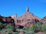
Castleton Tower is a 400 feet (121.9 m) Wingate Sandstone
tower standing on a 1,000 foot talus cone
above the northeastern border of Castle Valley, Utah
. The Tower is world renowned as a subject for photography and for its classic rock climbing
routes, the most famous of which is the Kor-Ingalls Route featured in Fifty Classic Climbs of North America
. Castleton Tower can be accessed by a trail that begins south of the tower at a primitive camp ground.
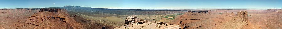
 Castleton Tower sits at the southern terminus of a ridge made mostly of red sand, gravel, scatter boulders, and few short cliff lines. The ridge that runs north to south for about 2800 feet (853.4 m) at its high point. Castleton Tower (~40'x400') shares the ridge with a structure at the ridge's Northern terminus with a similar height but considerable larger area known as The Rectory (~200'x1000'). This second structure is also referred to as The Priest and Nuns although those names are more often applied to specific structures connected to or contained in The Rectory. The nearest town is Moab, Utah
about 10 miles (16.1 km) to the southwest and the area is generally accessed from Castleton Road off of Route 128
which runs along the Colorado River
between I-70
and Route 191
. The La Sal Range
and the Manti-La Sal National Forest
is visible to the Southeast, The Fisher Towers
are visible to the Northeast, and the Colorado River with its associated cliffs lies to the Castleton 's Northwest.
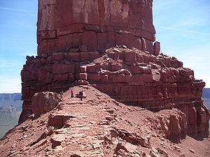
and Huntley Ingalls. Their route of ascent is still the most popular and carries their name, the Kor-Ingalls Route
, and is rated 5.9
. Today there are named routes of ascent on every aspect of the tower.
land-developer with a local partner who planned to subdivide the land creating lots for residential housing. This plan would have eliminated the Tower's camping ground and reduced recreational access to the Tower's base. In response the Castle Rock Collaboration (CRC) formed to prevent commercial development. Over the next two years the CRC and partners were able to raise the money necessary to purchase the land initially bought by the developers and then work with SITLA to secure more land as open space. Thus far 221 acre (0.89435606 km²) of the land that encompass the Tower have been protected, and is now held by the Utah Open Lands
, a nonprofit land trust.
Wingate Sandstone
Wingate Sandstone is a geologic formation in the Glen Canyon Group that is spread across the Colorado Plateau province of the United States, including northern Arizona, northwest Colorado, Nevada, and Utah. This rock formation is particularly prominent in southeastern Utah, where it forms...
tower standing on a 1,000 foot talus cone
Scree
Scree, also called talus, is a term given to an accumulation of broken rock fragments at the base of crags, mountain cliffs, or valley shoulders. Landforms associated with these materials are sometimes called scree slopes or talus piles...
above the northeastern border of Castle Valley, Utah
Castle Valley, Utah
Castle Valley is a town in Grand County, Utah, United States. The population was 349 at the 2000 census. The town is about 16 miles northeast of Moab near State Route 128.-Geography:Castle Valley is located at ....
. The Tower is world renowned as a subject for photography and for its classic rock climbing
Rock climbing
Rock climbing also lightly called 'The Gravity Game', is a sport in which participants climb up, down or across natural rock formations or artificial rock walls. The goal is to reach the summit of a formation or the endpoint of a pre-defined route without falling...
routes, the most famous of which is the Kor-Ingalls Route featured in Fifty Classic Climbs of North America
Fifty Classic Climbs of North America
Fifty Classic Climbs Of North America is a climbing guidebook and history written by Steve Roper and Allen Steck. It is considered a definitive piece of climbing literature, known to many climbers as simply "The Book", and has served as an inspiration for more recent climbing books, such as Mark...
. Castleton Tower can be accessed by a trail that begins south of the tower at a primitive camp ground.
Location
Moab, Utah
Moab is a city in Grand County, in eastern Utah, in the western United States. The population was 4,779 at the 2000 census. It is the county seat and largest city in Grand County. Moab hosts a large number of tourists every year, mostly visitors to the nearby Arches and Canyonlands National Parks...
about 10 miles (16.1 km) to the southwest and the area is generally accessed from Castleton Road off of Route 128
Utah State Route 128
State Route 128 is a state highway in the U.S. state of Utah. The entire length of the highway has been designated the Upper Colorado River Scenic Byway, as part of the Utah Scenic Byways program. This road also forms part of the Dinosaur Diamond Prehistoric Highway, a National Scenic Byway...
which runs along the Colorado River
Colorado River
The Colorado River , is a river in the Southwestern United States and northwestern Mexico, approximately long, draining a part of the arid regions on the western slope of the Rocky Mountains. The watershed of the Colorado River covers in parts of seven U.S. states and two Mexican states...
between I-70
Interstate 70
Interstate 70 is an Interstate Highway in the United States that runs from Interstate 15 near Cove Fort, Utah, to a Park and Ride near Baltimore, Maryland. It was the first Interstate Highway project in the United States. I-70 approximately traces the path of U.S. Route 40 east of the Rocky...
and Route 191
U.S. Route 191 in Utah
U.S. Route 191 is a major north–south state highway through the eastern part of the U.S. state of Utah. The present alignment of US-191, which stretches from Mexico to Canada, was created in 1981 through Utah...
. The La Sal Range
La Sal Range
The La Sal Mountains are located in Grand and San Juan counties, near the eastern border of the state of Utah, and rising above the town of Moab. This range is part of the Manti-La Sal National Forest and the southern Rocky Mountains. The maximum elevation is at Mount Peale, reaching 12,721 feet ...
and the Manti-La Sal National Forest
Manti-La Sal National Forest
The Manti-La Sal National Forest covers 1,270,646 acres and is located in the central and southeastern parts of the U.S. state of Utah and the extreme western part of Colorado...
is visible to the Southeast, The Fisher Towers
Fisher Towers
Fisher Towers are a series of towers made of Cutler sandstone capped with Moenkopi sandstone and caked with a stucco of red mud located near Moab, Utah . The Towers are named for a miner who lived near them in the 1880s. The Tower is world renowned as a subject for photography and for its classic...
are visible to the Northeast, and the Colorado River with its associated cliffs lies to the Castleton 's Northwest.
Ascent History
Among the most popular rock climbing destinations in the world, Castleton Tower has been summitted by thousands. Climbing historian Stewart Green reports that the number of successful ascents is over 40,000 and there have been so many that "no one really knows how many folks have reached the summit." The first ascent was completed September 16, 1961 by Layton KorLayton Kor
Layton Kor is an American rock climber active in the 1960s, whose first ascents and drive for climbing are well known in the climbing world. His routes include many climbs in Eldorado Canyon, near Boulder, Colorado, The Diamond on Longs Peak, towers in the desert southwest, and Yosemite National...
and Huntley Ingalls. Their route of ascent is still the most popular and carries their name, the Kor-Ingalls Route
Kor-Ingalls Route (Castleton Tower)
The Kor-Ingalls Route is a traditional rock climbing route located on Castleton Tower. Castleton Tower sits in Castle Valley North-East of Moab, Utah. The Route is recognized in the historic climbing text Fifty Classic Climbs of North America and considered a classic around the world.- External...
, and is rated 5.9
Yosemite Decimal System
The Yosemite Decimal System is a three-part system used for rating the difficulty of walks, hikes, and climbs. It is primarily used by mountaineers in the United States and Canada. The Class 5 portion of the Class scale is primarily a rock climbing classification system. Originally the system was...
. Today there are named routes of ascent on every aspect of the tower.
Preservation
Much of the land in Castle Valley is or has been owned by Utah's School and Institutional Trust Lands Administration (SITLA). The SITLA is a state land trust which auctions and leases lands to private interests in order to fund Utah schools and related state institutions. In the spring of 1999 SITLA auctioned off one or two parcels of land extending to between 60 acres (242,811.6 m²) and 120 acres (485,623.2 m²), depending on the referenced report. The land initially went to an Aspen, ColoradoAspen, Colorado
The City of Aspen is a Home Rule Municipality that is the county seat and the most populous city of Pitkin County, Colorado, United States. The United States Census Bureau estimates that the city population was 5,804 in 2005...
land-developer with a local partner who planned to subdivide the land creating lots for residential housing. This plan would have eliminated the Tower's camping ground and reduced recreational access to the Tower's base. In response the Castle Rock Collaboration (CRC) formed to prevent commercial development. Over the next two years the CRC and partners were able to raise the money necessary to purchase the land initially bought by the developers and then work with SITLA to secure more land as open space. Thus far 221 acre (0.89435606 km²) of the land that encompass the Tower have been protected, and is now held by the Utah Open Lands
Utah Open Lands Conservation Association
Utah Open Lands Conservation Association is a non-profit land trust conservation association in the United States.It is chartered to preserve and protect open space in order to maintain Utah’s natural heritage and quality of life for present and future generations...
, a nonprofit land trust.