

Carlin stone
Encyclopedia
Cailleach
In Irish and Scottish mythology, the , also known as the Cailleach Bheur, is a divine hag, a creatrix, and possibly an ancestral deity or deified ancestor...
.
Etymology
A 'Carle' in ScotsScots language
Scots is the Germanic language variety spoken in Lowland Scotland and parts of Ulster . It is sometimes called Lowland Scots to distinguish it from Scottish Gaelic, the Celtic language variety spoken in most of the western Highlands and in the Hebrides.Since there are no universally accepted...
is a commoner, a husband or in a derogatory sense, a churl
Churl
A churl , in its earliest Old English meaning, was simply "a man", but the word soon came to mean "a non-servile peasant", still spelt ċeorl, and denoting the lowest rank of freemen...
or male of low birth. The name 'Carline', 'Cairlin', Carlin, 'Cyarlin', 'Kerlin' or 'Kerl' was also used in lowland Scots as a derogatory term for an old woman meaning an 'old hag'. It is from Old Norse Kerling or a corruption or equivalent in Scots of the Gaelic word “Cailleach
Cailleach
In Irish and Scottish mythology, the , also known as the Cailleach Bheur, is a divine hag, a creatrix, and possibly an ancestral deity or deified ancestor...
”, meaning a witch or the 'old Hag', the Goddess of Winter.
Carlin is used as a surname and has several variations e.g., Carlen, Carlon, Carolan, O'Carlin, O'Carlen, O'Carlon, O'Carolan, Carling, Carlton, etc. It is stated as being of Irish Gaelic origin and is found somewhat less frequently in Scotland.
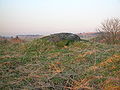
Alvah, Aberdeenshire
Near Sandlaw Farm in the parish of Alvah is the Carlin Cist, thought to have been part of a CromlechCromlech
Cromlech is a Brythonic word used to describe prehistoric megalithic structures, where crom means "bent" and llech means "flagstone". The term is now virtually obsolete in archaeology, but remains in use as a colloquial term for two different types of megalithic monument.In English it usually...
at one time.
Backhill of Drachlaw, Aberdeenshire
This stone was part of a recumbent stone circle, around 95 ft (29 m) in diameter. It has several alternative names, such as the Caerlin stone; Cairn Riv; Cairn Rib; or Cairn-Rieve. Its map reference in the parish of Inverkeithny is NJ 6744 4659. Three stones remain in line, the Carlin Stone between two others quite small in comparison. In addition, there are two set stones projecting inward from the Carlin Stone.This boulder is rugged, unshapely, and most unusual in height. Other stones were broken up and removed within relatively recent times; the mounds of stones being carted away for making dikes or drystone walls. In or near the circle were found a small perforated axe-hammer, portions of 3 bronze armlets, flint chips and a jet button.
Bishop Hill, Perth and Kinross
This natural stone outcrop is known as Carlin Maggie and has the look of something imported from Easter IslandEaster Island
Easter Island is a Polynesian island in the southeastern Pacific Ocean, at the southeasternmost point of the Polynesian triangle. A special territory of Chile that was annexed in 1888, Easter Island is famous for its 887 extant monumental statues, called moai, created by the early Rapanui people...
, but it is natural. It is said to be a witch turned to stone by the Devil
Devil
The Devil is believed in many religions and cultures to be a powerful, supernatural entity that is the personification of evil and the enemy of God and humankind. The nature of the role varies greatly...
after she got on his nerves. The Devil threw a lightning bolt which had the effect of petrifying her. It is a rock pillar estimated to be 30 feet (9.1 m) high, on the Western slope of Bishop Hill
Lomond Hills
The Lomond Hills , also known as the Paps of Fife lie in the centre of Fife, Scotland. At 522m West Lomond is the highest point in the county of Fife.-Natural geography:...
, overlooking Loch Leven. The OS
Ordnance Survey
Ordnance Survey , an executive agency and non-ministerial government department of the Government of the United Kingdom, is the national mapping agency for Great Britain, producing maps of Great Britain , and one of the world's largest producers of maps.The name reflects its creation together with...
grid reference is NO 18403 04413.
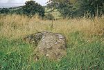
Dunlop, North Ayrshire
Dunlop, East Ayrshire
Dunlop is a village and parish in East Ayrshire, Scotland. It lies on the A735, north-east of Stewarton, seven miles from Kilmarnock. The road runs on to Lugton and the B706 enters the village from Beith.-The village:...
and the Glazert Water
River Irvine
The River Irvine is a river flowing through southwest Scotland, with its watershed on the Lanarkshire border of Ayrshire at an altitude of above sea-level, near Drumclog, and SW by W of Strathaven...
is a large procumbent boulder known on the OS map
Ordnance Survey
Ordnance Survey , an executive agency and non-ministerial government department of the Government of the United Kingdom, is the national mapping agency for Great Britain, producing maps of Great Britain , and one of the world's largest producers of maps.The name reflects its creation together with...
as the ‘Carlin’s Stone or Stane’. It is also known locally as the Hag's Stone.
It is not listed by the RCAHMS and is not as well known locally as the nearby megalith
Megalith
A megalith is a large stone that has been used to construct a structure or monument, either alone or together with other stones. Megalithic describes structures made of such large stones, utilizing an interlocking system without the use of mortar or cement.The word 'megalith' comes from the Ancient...
known as the Thurgartstone
Thurgartstone
The Thurgatstane or Ogrestane is a famous stone near Dunlop in East Ayrshire in Scotland. The Thurgatsane is thought to have been a rocking stone at one time, but it no longer rocks.-Name:...
.
55°42′47.9"N 4°31′20.6"W
Darvel, East Ayrshire
Three farms named 'Carlingcrags' on the Ordnance SurveyOrdnance Survey
Ordnance Survey , an executive agency and non-ministerial government department of the Government of the United Kingdom, is the national mapping agency for Great Britain, producing maps of Great Britain , and one of the world's largest producers of maps.The name reflects its creation together with...
maps are to be found above Darvel
Darvel
Darvel is a small town in East Ayrshire, Scotland, located at the eastern end of the Irvine Valley and is sometimes referred to as "The Lang Toon" due to its quaint appearance on Ordnance Survey maps....
in East Ayrshire.
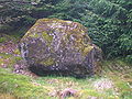
Waterside, East Ayrshire
East Ayrshire
East Ayrshire is one of 32 council areas of Scotland. It borders on to North Ayrshire, East Renfrewshire, South Lanarkshire, South Ayrshire and Dumfries and Galloway...
. A nearby watercourse is known as the Carlin Burn
River Irvine
The River Irvine is a river flowing through southwest Scotland, with its watershed on the Lanarkshire border of Ayrshire at an altitude of above sea-level, near Drumclog, and SW by W of Strathaven...
, joining the Hareshawmuir water just below the site of the Carlin stone. The stone has been much visited in the past; indicated by the remains of a footbridge running to it across the Hareshawmuir Water.55°39′34.6"N 4°20′59.7"W
Knockshinnoch, East Ayrshire
Carlin knowe is a low hill with a prehistoric cairn on its summit near Knockshinnoch farm.Carlins Cairn, Dumfries and Galloway
This is a mountain in the south-west of CarsphairnCarsphairn
Carsphairn is a village in Dumfries and Galloway, Scotland. It is located about half way between Dalmellington and St. John's Town of Dalry, next to the A713 road. Carsphairn annual sheep show is held in the village. Cairnsmore of Carsphairn is to the north east of the village in the Carsphairn...
parish.
Castle Douglas, Dumfries and Galloway
This town was known as Carlinwark until 1792. The title came from nearby Carlinwark loch in the north of the parish of Kelton.Wigtown, Dumfries and Galloway
A Carlin Stone is to ben found at 'The Derry', near to the head of Elrig Loch near WigtownWigtown
Wigtown is a town and former royal burgh in the Machars of Galloway in the south west of Scotland. It lies south of Newton Stewart and east of Stranraer. It has a population of about 1,000...
. It isn thought to have been part of a Stone circle
Stone circle
A stone circle is a monument of standing stones arranged in a circle. Such monuments have been constructed across the world throughout history for many different reasons....
and is situated at the OS Map
Ordnance Survey
Ordnance Survey , an executive agency and non-ministerial government department of the Government of the United Kingdom, is the national mapping agency for Great Britain, producing maps of Great Britain , and one of the world's largest producers of maps.The name reflects its creation together with...
Reference NX326497.
Scottish Borders
The Carlin's Tooth is the name of a natural rock outcrop in the borders between Knocks Knowe and Carter Fell.Miscellany
Near Kirkhill outside StewartonStewarton
Stewarton is a town in East Ayrshire, Scotland. In comparison to the neighbouring towns of Kilmaurs, Fenwick, Dunlop and Lugton, it is a relatively large town, with a population of over 6,500. It is 300 feet above sea level.Groome, Francis H. . Ordnance Gazetteer of Scotland. Pub. Caxton. London....
are several farms having the name 'Kilbride' in their title. Bride - an anglicization of Brìghde
Brigid
In Irish mythology, Brigit or Brighid was the daughter of the Dagda and one of the Tuatha Dé Danann. She was the wife of Bres of the Fomorians, with whom she had a son, Ruadán....
, Brìd or Saint Brigid
Brigid of Kildare
Saint Brigit of Kildare, or Brigit of Ireland , nicknamed Mary of the Gael is one of Ireland's patron saints along with Saints Patrick and Columba...
- was originally the Celtic Goddess linked with the festival of Imbolc
Imbolc
Imbolc , or St Brigid’s Day , is an Irish festival marking the beginning of spring. Most commonly it is celebrated on 1 or 2 February in the northern hemisphere and 1 August in the southern hemisphere...
, the eve of the first of February. She was the goddess of Spring and was associated with healing and sacred wells, therefore the antithesis of the Carlin or Cailleach
Cailleach
In Irish and Scottish mythology, the , also known as the Cailleach Bheur, is a divine hag, a creatrix, and possibly an ancestral deity or deified ancestor...
.
Papers in the Scottish National Archive state that the lands of Kilbride Cunninghame near Stewarton were also called the 'Lands of Carlin.'