
Carbrain, Cumbernauld
Encyclopedia
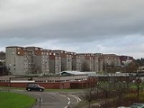
Carbrain is a neighborhood in the Scottish
new town
of Cumbernauld
in North Lanarkshire
. Construction of Cumbernauld began in 1963, and most areas of Carbrain were inhabited by the early 1970s. For the first several years, Carbrain was considered to be highly desirable as an escape from poor housing and lack of employment opportunities in the Glasgow
area. As newer developments have been constructed in the Cumbernauld area, Carbrain has fallen into disrepair.
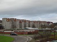
Carbrain was split into two sections: North and South. North Carbrain included areas such as Stonylee Road, Torbrex Road, Glenhove Road and Beechwood Road. North Carbrain is within five minutes walking distance from the town centre, health centre and sports centre. South Carbrain includes Kilbowie Road, Greenrigg Road, Broomlands Road, Sandyknowes, some of which are a five minute walk from the train station. The town centre is approximately a ten minute walk from South Carbrain.
 Carbrain was designed around pedestrians and, as such, has paths intertwining among its many streets. It is possible to get from one part of Carbrain to another using only footpaths. It was also designed so that pedestrians never had to walk alongside or cross a road.
There were three primary schools and a high school within this area. Most children who lived in these areas would have attended Langlands Primary, St Joseph's Primary or Carbrain Primary, and later Cumbernauld High School
, Greenfaulds High School
or Our Lady's High School. As of 2006, Cumbernauld has lost many of its older and smaller primary schools, such as Langlands, which have been combined into numerous larger primary schools.
Carbrain Primary celebrated its 40th birthday in 2006 and had two school concerts, inviting parents, ex-pupils and ex-teachers to attend. It is very close to the town centre including the refurbished and extended shopping area, renamed the Antonine Centre, after the Antonine Wall
a Roman antiquity.
Scotland
Scotland is a country that is part of the United Kingdom. Occupying the northern third of the island of Great Britain, it shares a border with England to the south and is bounded by the North Sea to the east, the Atlantic Ocean to the north and west, and the North Channel and Irish Sea to the...
new town
New town
A new town is a specific type of a planned community, or planned city, that was carefully planned from its inception and is typically constructed in a previously undeveloped area. This contrasts with settlements that evolve in a more ad hoc fashion. Land use conflicts are uncommon in new...
of Cumbernauld
Cumbernauld
Cumbernauld is a Scottish new town in North Lanarkshire. It was created in 1956 as a population overspill for Glasgow City. It is the eighth most populous settlement in Scotland and the largest in North Lanarkshire...
in North Lanarkshire
North Lanarkshire
North Lanarkshire is one of 32 council areas in Scotland. It borders onto the northeast of the City of Glasgow and contains much of Glasgow's suburbs and commuter towns and villages. It also borders Stirling, Falkirk, East Dunbartonshire, West Lothian and South Lanarkshire...
. Construction of Cumbernauld began in 1963, and most areas of Carbrain were inhabited by the early 1970s. For the first several years, Carbrain was considered to be highly desirable as an escape from poor housing and lack of employment opportunities in the Glasgow
Glasgow
Glasgow is the largest city in Scotland and third most populous in the United Kingdom. The city is situated on the River Clyde in the country's west central lowlands...
area. As newer developments have been constructed in the Cumbernauld area, Carbrain has fallen into disrepair.
Carbrain was split into two sections: North and South. North Carbrain included areas such as Stonylee Road, Torbrex Road, Glenhove Road and Beechwood Road. North Carbrain is within five minutes walking distance from the town centre, health centre and sports centre. South Carbrain includes Kilbowie Road, Greenrigg Road, Broomlands Road, Sandyknowes, some of which are a five minute walk from the train station. The town centre is approximately a ten minute walk from South Carbrain.
There were three primary schools and a high school within this area. Most children who lived in these areas would have attended Langlands Primary, St Joseph's Primary or Carbrain Primary, and later Cumbernauld High School
Cumbernauld High School
Cumbernauld High School was the first comprehensive secondary school in the then 'New Town' of Cumbernauld. It opened in 1964 and is a non-denominational, co-educational, secondary school...
, Greenfaulds High School
Greenfaulds High School
Greenfaulds High School is a non-denominational six-year comprehensive secondary school, which was opened in 1971. Greenfaulds is situated in the west of Cumbernauld and provides a service to the Greenfaulds, Ravenswood, Condorrat, Westfield, Eastfield, Balloch areas and parts of Seafar.The head...
or Our Lady's High School. As of 2006, Cumbernauld has lost many of its older and smaller primary schools, such as Langlands, which have been combined into numerous larger primary schools.
Carbrain Primary celebrated its 40th birthday in 2006 and had two school concerts, inviting parents, ex-pupils and ex-teachers to attend. It is very close to the town centre including the refurbished and extended shopping area, renamed the Antonine Centre, after the Antonine Wall
Antonine Wall
The Antonine Wall is a stone and turf fortification built by the Romans across what is now the Central Belt of Scotland, between the Firth of Forth and the Firth of Clyde. Representing the northernmost frontier barrier of the Roman Empire, it spanned approximately 39 miles and was about ten feet ...
a Roman antiquity.