
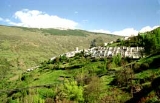
Capileira
Encyclopedia
Capileira is the highest and most northerly of the three villages in the gorge of the Poqueira river
in the La Alpujarra
district of the province of Granada, in Spain
. It is located at latitude
36° 57' N and longitude
3° 21' W, about 1 km north of Bubión
. Its altitude is officially recorded as 1436 metres, though there is a considerable altitude difference between the oldest part of the village, which is at the lower, southern end, and the highest part, where tourist-oriented development is currently concentrated. The area of the municipality is 57 km².
Although the Sierra Nevada Highway runs through Capileira and out across the Sierra Nevada
mountains towards the city of Granada
, motor traffic is no longer permitted to continue across the mountains; Capileira is therefore the highest village that public traffic can reach, although you can continue to a car park where the National park begins and the road is barred to normal traffic. The National Park runs a limited bus service on the now-closed road (reservations handled by office in the village) in summer. A track leads northwards from the village to the abandoned settlement of La Cebadilla, built to house the workers who developed the hydro-electric installation at the upper end of the Poqueira Gorge.
Capileira has developed a significant tourist trade, acting as a centre for walking
and for accessing the mountains especially Mulhacén
, generally treated as a two-day climb from Capileira with an overnight stop at a mountain refuge en route. A bus
route connects the village to Granada (via Lanjarón
and Órgiva
) and Alcútar (via Trevélez
and Juviles
); there were 3 services per day in each direction. The village has good facilities for visitors including a number of restaurants,a market on Tuesdays, hotels and apartment blocks, but retains a typical Alpujarran character especially away from the main road. Its population in 2005 was recorded as 582 people, of whom 35 did not have Spanish nationality, most of them being citizens of other European Union
countries. The village has a primary school but no secondary school.
Poqueira River
thumb|250px|right|Puente del Molino over the Río Poqueira, between Bubión and CapileiraThe Río Poqueira is a river in La Alpujarra region in the province of Granada, in Spain. It is formed for the confluence of streams that rise near the summit of Mulhacén, the highest peak of the Sierra Nevada...
in the La Alpujarra
Alpujarras
thumb|250px|A typical Alpujarran village, [[Busquístar]].La Alpujarra is a landlocked historical region in Southern Spain, which stretches south from the Sierra Nevada mountains near Granada in the autonomous community of Andalusia. The western part of the region lies in the province of Granada...
district of the province of Granada, in Spain
Spain
Spain , officially the Kingdom of Spain languages]] under the European Charter for Regional or Minority Languages. In each of these, Spain's official name is as follows:;;;;;;), is a country and member state of the European Union located in southwestern Europe on the Iberian Peninsula...
. It is located at latitude
Latitude
In geography, the latitude of a location on the Earth is the angular distance of that location south or north of the Equator. The latitude is an angle, and is usually measured in degrees . The equator has a latitude of 0°, the North pole has a latitude of 90° north , and the South pole has a...
36° 57' N and longitude
Longitude
Longitude is a geographic coordinate that specifies the east-west position of a point on the Earth's surface. It is an angular measurement, usually expressed in degrees, minutes and seconds, and denoted by the Greek letter lambda ....
3° 21' W, about 1 km north of Bubión
Bubión
Bubión is a village in La Alpujarra region of Granada in Spain. It is located at latitude 36° 57' N, longitude 3° 21' W, at 1,350 metres above sea level. Its postal code is 18412...
. Its altitude is officially recorded as 1436 metres, though there is a considerable altitude difference between the oldest part of the village, which is at the lower, southern end, and the highest part, where tourist-oriented development is currently concentrated. The area of the municipality is 57 km².
Although the Sierra Nevada Highway runs through Capileira and out across the Sierra Nevada
Sierra Nevada (Spain)
The Sierra Nevada is a mountain range in the region of provinces of Granada and Almería in Spain. It contains the highest point of continental Spain, Mulhacén at 3478 m above sea level....
mountains towards the city of Granada
Granada
Granada is a city and the capital of the province of Granada, in the autonomous community of Andalusia, Spain. Granada is located at the foot of the Sierra Nevada mountains, at the confluence of three rivers, the Beiro, the Darro and the Genil. It sits at an elevation of 738 metres above sea...
, motor traffic is no longer permitted to continue across the mountains; Capileira is therefore the highest village that public traffic can reach, although you can continue to a car park where the National park begins and the road is barred to normal traffic. The National Park runs a limited bus service on the now-closed road (reservations handled by office in the village) in summer. A track leads northwards from the village to the abandoned settlement of La Cebadilla, built to house the workers who developed the hydro-electric installation at the upper end of the Poqueira Gorge.
Capileira has developed a significant tourist trade, acting as a centre for walking
Hiking
Hiking is an outdoor activity which consists of walking in natural environments, often in mountainous or other scenic terrain. People often hike on hiking trails. It is such a popular activity that there are numerous hiking organizations worldwide. The health benefits of different types of hiking...
and for accessing the mountains especially Mulhacén
Mulhacén
Mulhacén is the highest mountain in continental Spain and in the Iberian Peninsula. It is part of the Sierra Nevada range in the Cordillera Penibética...
, generally treated as a two-day climb from Capileira with an overnight stop at a mountain refuge en route. A bus
Bus
A bus is a road vehicle designed to carry passengers. Buses can have a capacity as high as 300 passengers. The most common type of bus is the single-decker bus, with larger loads carried by double-decker buses and articulated buses, and smaller loads carried by midibuses and minibuses; coaches are...
route connects the village to Granada (via Lanjarón
Lanjarón
Lanjarón is a municipality and town in the Alpujarras area in the province of Granada in Andalusia, Spain.Lanjarón has a ruined castle and chalybeate baths....
and Órgiva
Órgiva
Órgiva is a municipality in the Alpujarra mountains in Spain. It has a population of around 6,000 and lies in a depression between the Sierra de Lujar and Sierra Nevada. In recent years it has become a popular tourist destination for those visiting La Alpujarra, and the town is often described as...
) and Alcútar (via Trevélez
Trevélez
Trevélez is a village in the province of Granada, Spain. Its population in 2002 was estimated at 799. The river Trevélez flows through the village...
and Juviles
Juviles
Juviles is a village and municipality in the central Alpujarras, in the province of Granada in Spain. The village is located at 36° 57' north and 3° 13' east, and stands at an altitude of 1,255 metres, on the road from Trevélez to Ugíjar...
); there were 3 services per day in each direction. The village has good facilities for visitors including a number of restaurants,a market on Tuesdays, hotels and apartment blocks, but retains a typical Alpujarran character especially away from the main road. Its population in 2005 was recorded as 582 people, of whom 35 did not have Spanish nationality, most of them being citizens of other European Union
European Union
The European Union is an economic and political union of 27 independent member states which are located primarily in Europe. The EU traces its origins from the European Coal and Steel Community and the European Economic Community , formed by six countries in 1958...
countries. The village has a primary school but no secondary school.
External links
- Capileira - Sistema de Información Multiterritorial de Andalucía
- Tourist information and Las Alpujarras community portal - Capileira