

Cape Sorell, Tasmania
Encyclopedia
Lighthouse
A lighthouse is a tower, building, or other type of structure designed to emit light from a system of lamps and lenses or, in older times, from a fire, and used as an aid to navigation for maritime pilots at sea or on inland waterways....
located outside of Macquarie Harbour
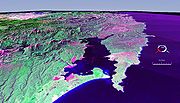
Macquarie Harbour
Macquarie Harbour is a large, shallow, but navigable by shallow draft vessels inlet on the West Coast of Tasmania, Australia.-History:James Kelly wrote in his narrative "First Discovery of Port Davey and Macquarie Harbour" how he sailed from Hobart in a small open five-oared whaleboat to discover...
on the West Coast
West Coast, Tasmania
The West Coast of Tasmania is the part of the state that is strongly associated with wilderness, mining and tourism, rough country and isolation...
of Tasmania
Tasmania
Tasmania is an Australian island and state. It is south of the continent, separated by Bass Strait. The state includes the island of Tasmania—the 26th largest island in the world—and the surrounding islands. The state has a population of 507,626 , of whom almost half reside in the greater Hobart...
.
It is an important orientation point for all vessels entering Macquarie Heads - and then through Hells Gates
Hell's Gates (Tasmania)
Hells Gates is the name of the mouth of Macquarie Harbour on the West Coast of Tasmania. It is a notoriously shallow and dangerous channel entrance to the harbour. The actual channel is between Cape Sorell, Tasmania on the west and Entrance Island on the east...
at the entrance to the harbour.
It is named after Lieutenant-Governor of Tasmania
Governors of Tasmania
The Governor of Tasmania is the representative in the Australian state of Tasmania of Elizabeth II, Queen of Australia. The Governor performs the same constitutional and ceremonial functions at the state level as the Governor-General of Australia does at the national level.In accordance with the...
William Sorell
William Sorell
William Sorell was a soldier and third Lieutenant-Governor of Van Diemen's Land.-Early life:Sorell was born probably in the West Indies, the eldest son of Lieutenant-general William Alexander Sorell and his wife Jane...
who was lieutenant-governor from 1817 to 1824.
Lighthouse
Cape Sorell Lighthouse is on the Australian Heritage RegisterRegister of the National Estate
The Register of the National Estate is a listing of natural and cultural heritage places in Australia. The listing was initially compiled between 1976 and 2003 by the Australian Heritage Commission. The register is now maintained by the Australian Heritage Council...
. It was inaugurated in 1899. The light characteristic is a group of two flashes that occurs every fifteen seconds, its focal plane is at 51 metres above sea level. Originally, the site had a number of keeper's houses which were torn down though in 1988.
Waverider Buoy
The Cape Sorell Waverider Buoy is a swellSwell (ocean)
A swell, in the context of an ocean, sea or lake, is a series surface gravity waves that is not generated by the local wind. Swell waves often have a long wavelength but this varies with the size of the water body, e.g. rarely more than 150 m in the Mediterranean, and from event to event, with...
-measuring buoy located west of Cape Sorell some 10 km kilometres west of Ocean Beach
Ocean Beach, Tasmania
Ocean Beach is a long stretch of beach running north of Macquarie Heads and Hells Gates on the West Coast of Tasmania. It is close to Strahan and parallel to the Strahan Airport runway...
(42°12′S 145°03′E).
It is unique in that it is one of the few wave-riding swell measuring buoys close to land in the region within the Roaring Forties
Roaring Forties
The Roaring Forties is the name given to strong westerly winds found in the Southern Hemisphere, generally between the latitudes of 40 and 49 degrees. Air displaced from the Equator towards the South Pole, which travels close to the surface between the latitudes of 30 and 60 degrees south, combines...
of the Southern Ocean
Southern Ocean
The Southern Ocean comprises the southernmost waters of the World Ocean, generally taken to be south of 60°S latitude and encircling Antarctica. It is usually regarded as the fourth-largest of the five principal oceanic divisions...
apart from those in New Zealand
New Zealand
New Zealand is an island country in the south-western Pacific Ocean comprising two main landmasses and numerous smaller islands. The country is situated some east of Australia across the Tasman Sea, and roughly south of the Pacific island nations of New Caledonia, Fiji, and Tonga...
.
Originally known as the 'Strahan
Strahan, Tasmania
-See also:* Convicts on the West Coast of Tasmania* Macquarie Harbour* Railways on the West Coast of Tasmania* West Coast Piners-Further reading:* *...
' waverider buoy it was deployed in January 1998 and had recorded maximum waves of 18 m within the first three months of operation. The Strahan buoy was supported by CMR which provides the moorings, and the Strahan fishing community which provides the resources to deploy and recover the buoy.
Earlier CSIRO
Commonwealth Scientific and Industrial Research Organisation
The Commonwealth Scientific and Industrial Research Organisation is the national government body for scientific research in Australia...
-funded wave-measuring buoys were installed in this area in the early 1990s.
The table and graph of the range of the swells is readily available on the internet links listed below. This link is sometimes displayed in the boats that conduct cruises across Macquarie Harbour and up Gordon River, as a means of illustrating the strength and intensity of the swells that meet Ocean Beach.
Winter swells range in the 4 to 10 metre range on the average. However it is claimed that it broke its moorings on a 23 metre swell within the last decade.
The buoy retained its mooring on 21 September 2006 when it reached a spike of 19.5 metres which was claimed to be the highest measured wave in Australian waters. - however this measurement has been modified due to the buoy's behaviour at the time of the measurement, and it is more likely to have been half that measurement.
On 16 September 2010 it measured up to 18.4 metres in extreme weather