

Canton Bridge Company
Encyclopedia
American Bridge Company
The American Bridge Company is a privately held civil engineering firm specializing in the construction and renovation of bridges and other large civil engineering projects, founded in 1900, and headquartered in Coraopolis, Pennsylvania, a suburb of Pittsburgh.-Products and industry positioning:The...
. The firm was established in Canton, Ohio
Canton, Ohio
Canton is the county seat of Stark County in northeastern Ohio, approximately south of Akron and south of Cleveland.The City of Caton is the largest incorporated area within the Canton-Massillon Metropolitan Statistical Area...
in 1892 and became one of the nation's biggest bridge-builders during the early 20th century. It designed and/or built many bridges that later became listed on the U.S. National Register of Historic Places
National Register of Historic Places
The National Register of Historic Places is the United States government's official list of districts, sites, buildings, structures, and objects deemed worthy of preservation...
(NRHP).
History
The Canton Bridge Company was founded in 1892 by Canton native John R. Reed. He was born in 1862 and as a young man was trained in publishing and got a job working for Canton's first daily newspaper in 1878. In 1880 he came to work for the Wrought Iron Bridge Company in Canton where he gained enough insight in the bridge construction trade to go into business for himself in 1892. His company soon became one of the largest bridge builders in the country. Mr. Reed left the company and moved to Joplin, MissouriJoplin, Missouri
Joplin is a city in southern Jasper County and northern Newton County in the southwestern corner of the US state of Missouri. Joplin is the largest city in Jasper County, though it is not the county seat. As of the 2010 census, the city population was 50,150...
in 1900 to work for the rival Massillon Bridge and Structural Company which was headquartered there.
Notable bridges
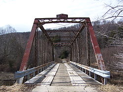
Notable bridges built by the firm include many that are NRHP-listed (and which then usually are still surviving). Others, not listed on the NRHP, also survive, including the Cheat Bridge, in West Virginia.Notable ones (by state then city):
- Wilson Pratt Truss BridgeWilson Pratt Truss BridgeThe Wilson Pratt Truss Bridge is a road bridge near Chapman, Kansas that was built in 1904. It was listed on the National Register of Historic Places in 2009....
, 2.9 m. W. of Rain Rd. on 3200 Ave., Chapman, KansasChapman, KansasChapman is a city in Dickinson County, Kansas, United States. As of the 2010 census, the city population was 1,393.-History:The first settlement was made at Chapman in 1868, and the same year Jackman's mill was built on Chapman creek a little northeast of the present town. James Streeter and S. M...
, NRHP-listed - Chapman Creek Pratt Truss BridgeChapman Creek Pratt Truss BridgeThe Chapman Creek Pratt Truss Bridge near Chapman, Kansas was built in 1905. It was listed on the National Register of Historic Places in 2003. It was designed and/or built by the Canton Bridge Co. and is a Pratt Truss bridge. It is also known as 21-HT-02 or as 08583.00436.6.-See also:*Wilson...
, Quail Rd., 1.7 mi. S of int. with KS 18, 2.5 mi. N of Chapman, Chapman, KansasChapman, KansasChapman is a city in Dickinson County, Kansas, United States. As of the 2010 census, the city population was 1,393.-History:The first settlement was made at Chapman in 1868, and the same year Jackman's mill was built on Chapman creek a little northeast of the present town. James Streeter and S. M...
, NRHP-listed - Sand Cree Truss Leg Bedstead Bridge, Rd. Y, 0.5 mi. W of int with KS 283, 2 mi. N of KS 9 and 6 mi. NE of Lenora, Lenora, KansasLenora, KansasLenora is a city in Norton County, Kansas, United States. As of the 2010 census, the city population was 250.-Geography:Lenora is located at . According to the United States Census Bureau, the city has a total area of , all of it land.-Demographics:As of the census of 2000, there were 306...
, NRHP-listed - North Fork Solomon River Lattice Truss Bridge, Rd. W&, 0.1 mi. S of int with Rd. BB, 1.5 mi. W of Lenora, Lenora, KansasLenora, KansasLenora is a city in Norton County, Kansas, United States. As of the 2010 census, the city population was 250.-Geography:Lenora is located at . According to the United States Census Bureau, the city has a total area of , all of it land.-Demographics:As of the census of 2000, there were 306...
, NRHP-listed - Battle Creek King Post Truss Bridge, W. Eagle Rd., 3.0 mi. E of jct. with Washington Rd., Long Island, KansasLong Island, KansasLong Island is a city in Phillips County, Kansas, United States. As of the 2010 census, the city population was 134.-Geography:Long Island is located at...
, NRHP-listed - Jack Creek Kingpost, SE of Long Island, Long Island, KansasLong Island, KansasLong Island is a city in Phillips County, Kansas, United States. As of the 2010 census, the city population was 134.-Geography:Long Island is located at...
, NRHP-listed - West Sappa Creek Lattice, NW of Norton over West Sappa Creek, Norton, KansasNorton, KansasNorton is a city in and the county seat of Norton County, Kansas, United States. As of the 2010 census, the city population was 2,928.-History:...
, NRHP-listed - Four Mile Creek Lattice, over Four Mile Creek, SE of Wilsey, Wilsey, KansasWilsey, KansasWilsey is a city in Morris County, Kansas, United States. As of the 2010 census, the city population was 153.-History:An agricultural-based community, Wilsey was named after pioneer John D. Wilsey. In the early 1880s, the Missouri Pacific Railroad was built through the county, at which time Wilsey...
, NRHP-listed - Swan Creek Bridge, N of Forsyth, Forsyth, MissouriForsyth, MissouriForsyth is a city in Taney County, Missouri, United States. The population was 1,686 at the 2000 census. It is the county seat of Taney County. The town is part of the Branson, Missouri Micropolitan Statistical Area-Geography:...
, NRHP-listed - Turkey Creek Bridge, Co. Rd. over Turkey Creek, 2 mi. W and 1 mi. S of Ragan, Ragan, NebraskaRagan, NebraskaRagan is a village in Harlan County, Nebraska, United States. The population was 46 at the 2000 census.-Geography:Ragan is located at .According to the United States Census Bureau, the village has a total area of , all of it land....
, NRHP-listed - Willow Creek Bridge, Co. Rd. over Willow Cr., 6.5 mi. S of Foster, Foster, NebraskaFoster, NebraskaFoster is a village in Pierce County, Nebraska, United States. It is part of the Norfolk, Nebraska Micropolitan Statistical Area. The population was 63 at the 2000 census.-Geography:Foster is located at ....
, NRHP-listed - Adamson Bridge, NE 97 over the Niobrara RiverNiobrara RiverThe Niobrara River is a tributary of the Missouri River, approximately long, running through the U.S. states of Wyoming and Nebraska. The river drains one of the most arid sections of the Great Plains, and has a low flow for a river of its length...
, 7.8 mi. SW of Valentine, NebraskaValentine, Nebraska-Demographics:As of the census of 2000, there were 2,820 people, 1,209 households, and 733 families residing in the city. The population density was 1,401.1 people per square mile . There were 1,373 housing units at an average density of 682.2 per square mile...
, NRHP-listed - Bell Bridge, Co. Rd. over the Niobrara R., 11.9 mi. NE of Valentine, Valentine, NebraskaValentine, Nebraska-Demographics:As of the census of 2000, there were 2,820 people, 1,209 households, and 733 families residing in the city. The population density was 1,401.1 people per square mile . There were 1,373 housing units at an average density of 682.2 per square mile...
, NRHP-listed - Big Blue River Bridge, Twp. Rd. over Big Blue RiverBig Blue River (Kansas)The Big Blue River is the largest tributary of the Kansas River. The river flows for approximately from central Nebraska into Kansas, where it intersects with the Kansas River east of Manhattan. It was given its name by the Kansa tribe of Native Americans, who lived at its mouth from 1780 to...
, 1 mi. SE of Surprise, Surprise, NebraskaSurprise, NebraskaSurprise is a village in Butler County, Nebraska, United States. The population was 44 at the 2000 census.-Geography:Surprise is located at ....
, NRHP-listed - Borman Bridge, Co. Rd. over the Niobrara RiverNiobrara RiverThe Niobrara River is a tributary of the Missouri River, approximately long, running through the U.S. states of Wyoming and Nebraska. The river drains one of the most arid sections of the Great Plains, and has a low flow for a river of its length...
, 2.3 mi. SE of Valentine, Valentine, NebraskaValentine, Nebraska-Demographics:As of the census of 2000, there were 2,820 people, 1,209 households, and 733 families residing in the city. The population density was 1,401.1 people per square mile . There were 1,373 housing units at an average density of 682.2 per square mile...
, NRHP-listed - Ranney BridgeRanney BridgeRanney Bridge is a historic Pratt Pony Truss Bridge over the Ausable River at Keene Valley in Essex County, New York. It was built in 1902 and was built by the Canton Iron Bridge Company. It was originally located at the hamlet of New Russia and moved to its present site about 1925...
, Private Rd. off NY 73 over East Branch of AuSable River, Keene Valley, New York, NRHP-listed as built by Canton Iron Bridge Company - Witherup Bridge, LR 60007 over Scrubgrass Creek, Kennerdell, Pennsylvania, NRHP-listed
- Vale Cut Off Belle Fourche River Bridge, 7 mi. SW of Newell, Belle Fourche, South DakotaBelle Fourche, South DakotaAccording to the United States Census Bureau, the city has a total area of , of which are land and is water.-Demographics:As of the census of 2000, there were 4,565 people, 1,854 households, and 1,186 families residing in the city. The population density was 1,446.9 people per square mile...
, NRHP-listed - South Dakota Dept. of Transportation Bridge No. 10-109-360, Local rd. over the Diversion Dam Inlet Canal, Belle Fourche Irrigation District, Belle Fourche, South DakotaBelle Fourche, South DakotaAccording to the United States Census Bureau, the city has a total area of , of which are land and is water.-Demographics:As of the census of 2000, there were 4,565 people, 1,854 households, and 1,186 families residing in the city. The population density was 1,446.9 people per square mile...
, NRHP-listed - South Dakota Dept. of Transportation Bridge No. 10-270-338, Local Rd. over Horse CreekHorse CreekHorse Creek is a stream in Solano County, California which discharges into Ulatis Creek.-Floodplain:The U.S. government has designated a portion of Horse Creek within the 100-year floodplain. In particular, within unincorporated Solano County approximately downstream and upstream of Willow...
, Newell, South DakotaNewell, South DakotaNewell is a city in Butte County, South Dakota, United States. The population was 603 at the 2010 census.-Geography:Newell is located at .According to the United States Census Bureau, the city has a total area of , all of it land....
, NRHP-listed - Stonelake Bridge, Winkler Rd., Newell, South DakotaNewell, South DakotaNewell is a city in Butte County, South Dakota, United States. The population was 603 at the 2010 census.-Geography:Newell is located at .According to the United States Census Bureau, the city has a total area of , all of it land....
, NRHP-listed - Vale Bridge, Local Rd. over Belle Fourche RiverBelle Fourche RiverThe Belle Fourche River is a tributary of the Cheyenne River, approximately long, in the U.S. states of Wyoming and South Dakota. It is part of the Mississippi River watershed via the Cheyenne and Missouri rivers....
, Vale, South DakotaVale, South DakotaVale is an unincorporated community in Butte County, South Dakota, United States. According to the 2010 Census, the population was 136. Vale has been assigned the ZIP code of 57788. Local businesses include the Last Call Bar, Leber Ag, and the BS Stop and Shop Cafe....
, NRHP-listed - Cheat Bridge, in Cheat Bridge, West VirginiaCheat Bridge, West VirginiaCheat Bridge is an unincorporated community in southeastern Randolph County, West Virginia, United States. It is located near U.S. Route 250's crossing of Shavers Fork.-The bridge:...
, a metal truss bridge - Stouts Mill BridgeStouts Mill BridgeThe Stouts Mill Bridge is a historic camel-back through truss bridge that brings Duskcamp Rd. over Little Kanawha River in Stouts Mill, Gilmer County, West Virginia. The bridge was built in 1897. It was designed and/or built by the Canton Bridge Company....
, Duskcamp Rd., over Little Kanawha RiverLittle Kanawha RiverThe Little Kanawha River is a tributary of the Ohio River, 169 mi long, in western West Virginia in the United States. Via the Ohio, it is part of the watershed of the Mississippi River, draining an area of 2,320 mi² on the unglaciated portion of the Allegheny Plateau...
, Stouts Mill, West Virginia, - ECS Bridge over Big Goose CreekECS Bridge over Big Goose CreekECS Bridge over Big Goose Creek is a bridge near Sheridan, Wyoming that was built during 1913-1914. It is a Pratt pony truss bridge, designed and/or built by the Canton Bridge Company.The bridge is 50 feet long and 15 feet wide....
, Cty. Rd. CN3-93, Sheridan, WyomingSheridan, WyomingSheridan is a city in Sheridan County, Wyoming, United States. The 2010 census put the population at 17,444 and a Micropolitan Statistical Area of 29,116...
, NRHP-listed - EDL Peloux Bridge, Cty. Rd. CN16-40, Buffalo, WyomingBuffalo, WyomingBuffalo is a city in Johnson County, Wyoming, United States. The population was 3,900 at the 2000 census. It is the county seat of Johnson County...
, NRHP-listed - EDZ Irigary Bridge, Cty. Rd. CN16-254, Sussex, Wyoming, NRHP-listed