
Cheat Bridge, West Virginia
Encyclopedia
Cheat Bridge is an unincorporated community
in southeastern Randolph County
, West Virginia
, United States
. It is located near U.S. Route 250
's crossing of Shavers Fork.
(3 October 1861), Union troops used the bridge when they built extensive military defenses at nearby Cheat Summit. Over 40 years later, celebrated satirist and short story writer Ambrose Bierce
revisited the site of his youthful service. He found that “…the old wooden covered bridge across the Cheat River looks hardly a day older, and is still elaborately decorated with soldiers’ names carven with jack-knives.”
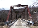
The current bridge is a steel truss bridge built in 1912 by the Canton Bridge Company
. It carries County Route 250/4, which provides access to adjacent Monongahela National Forest
lands. The existing bridge is in rather poor shape and has a 3-ton load limit. Today, U.S. Route 250
crosses the Shavers Fork River on a 1934 truss bridge located approximately 0.5 mile (0.80467 km) north of Cheat Bridge.
. Prior to 2008, the Cheat Mountain Salamander was powered by a railcar that departed from Cheat Bridge. Beginning in 2008, this train is now operated as a regular passenger train departing from the Elkins
depot
. For a shorter 3-hour trip to Spruce, passengers may still board at Cheat Bridge.
Unincorporated area
In law, an unincorporated area is a region of land that is not a part of any municipality.To "incorporate" in this context means to form a municipal corporation, a city, town, or village with its own government. An unincorporated community is usually not subject to or taxed by a municipal government...
in southeastern Randolph County
Randolph County, West Virginia
As of the census of 2000, there were 28,262 people, 11,072 households, and 7,661 families residing in the county. The population density was 27 people per square mile . There were 13,478 housing units at an average density of 13 per square mile...
, West Virginia
West Virginia
West Virginia is a state in the Appalachian and Southeastern regions of the United States, bordered by Virginia to the southeast, Kentucky to the southwest, Ohio to the northwest, Pennsylvania to the northeast and Maryland to the east...
, United States
United States
The United States of America is a federal constitutional republic comprising fifty states and a federal district...
. It is located near U.S. Route 250
U.S. Route 250
U.S. Route 250 is a route of the United States Numbered Highway System, and is a spur of U.S. Route 50. It currently runs for from Sandusky, Ohio to Richmond, Virginia. It passes through the states of Virginia, West Virginia, and Ohio. It goes through the cities of Richmond, Virginia,...
's crossing of Shavers Fork.
The bridge
As its name suggests, Cheat Bridge is named for the bridge over Shavers Fork of Cheat River located here and first built in the 19th century to service the Staunton-Parkersburg Turnpike. The original covered bridge was built before the American Civil War. After the Battle of Greenbrier RiverBattle of Greenbrier River
The Battle of Greenbrier River, also known as the Battle of Camp Bartow, took place on October 3, 1861 in Pocahontas County, Virginia as part of the Operations in Western Virginia Campaign during the American Civil War....
(3 October 1861), Union troops used the bridge when they built extensive military defenses at nearby Cheat Summit. Over 40 years later, celebrated satirist and short story writer Ambrose Bierce
Ambrose Bierce
Ambrose Gwinnett Bierce was an American editorialist, journalist, short story writer, fabulist and satirist...
revisited the site of his youthful service. He found that “…the old wooden covered bridge across the Cheat River looks hardly a day older, and is still elaborately decorated with soldiers’ names carven with jack-knives.”
The current bridge is a steel truss bridge built in 1912 by the Canton Bridge Company
Canton Bridge Company
Canton Bridge Company was a firm that was later incorporated into the American Bridge Company. The firm was established in Canton, Ohio in 1892 and became one of the nation's biggest bridge-builders during the early 20th century. It designed and/or built many bridges that later became listed on...
. It carries County Route 250/4, which provides access to adjacent Monongahela National Forest
Monongahela National Forest
The Monongahela National Forest is a national forest located in the Allegheny Mountains of eastern West Virginia, USA. It protects over of federally-owned land within a proclamation boundary that includes much of the Potomac Highlands Region and portions of 10 counties.The MNF includes some...
lands. The existing bridge is in rather poor shape and has a 3-ton load limit. Today, U.S. Route 250
U.S. Route 250
U.S. Route 250 is a route of the United States Numbered Highway System, and is a spur of U.S. Route 50. It currently runs for from Sandusky, Ohio to Richmond, Virginia. It passes through the states of Virginia, West Virginia, and Ohio. It goes through the cities of Richmond, Virginia,...
crosses the Shavers Fork River on a 1934 truss bridge located approximately 0.5 mile (0.80467 km) north of Cheat Bridge.
Durbin & Greenbrier Valley Railroad
Cheat Bridge also serves as a stop for the Cheat Mountain Salamander train operated by the Durbin and Greenbrier Valley RailroadDurbin and Greenbrier Valley Railroad
The Durbin and Greenbrier Valley Railroad is a heritage and freight railroad in the U.S. state of West Virginia. It operates the West Virginia State Rail Authority-owned Durbin Railroad and West Virginia Central Railroad , as well as the Shenandoah Valley Railroad in Virginia.-Trains:The DGVR...
. Prior to 2008, the Cheat Mountain Salamander was powered by a railcar that departed from Cheat Bridge. Beginning in 2008, this train is now operated as a regular passenger train departing from the Elkins
Elkins, West Virginia
Elkins is a city in Randolph County, West Virginia, United States. The community was incorporated in 1890 and named in honor of Stephen Benton Elkins , a U.S. Senator from West Virginia. The population was 7,032 at the 2000 census. It is the county seat of Randolph County...
depot
Train station
A train station, also called a railroad station or railway station and often shortened to just station,"Station" is commonly understood to mean "train station" unless otherwise qualified. This is evident from dictionary entries e.g...
. For a shorter 3-hour trip to Spruce, passengers may still board at Cheat Bridge.
See also
- Monongahela National ForestMonongahela National ForestThe Monongahela National Forest is a national forest located in the Allegheny Mountains of eastern West Virginia, USA. It protects over of federally-owned land within a proclamation boundary that includes much of the Potomac Highlands Region and portions of 10 counties.The MNF includes some...
- Gaudineer KnobGaudineer KnobGaudineer Knob is a mountain summit on the Randolph/Pocahontas County line in eastern West Virginia, USA. It is the highest elevation of Shavers Mountain, a ridge of the Alleghenies, and is located about east of the town of Cheat Bridge...
, located to the east on Shavers MountainShavers MountainShavers Mountain, is a high and rugged ridge situated in the Allegheny Mountains of eastern West Virginia. It is about long, north to south, and several of its peaks exceed in elevation... - White TopWhite TopWhite Top is a knob and spur of Cheat Mountain in southeastern Randolph County, West Virginia, USA. Sitting at an elevation of , it is located just west of the Shavers Fork of Cheat River and Cheat Bridge. While White Top was originally crossed by the Staunton-Parkersburg Turnpike, modern-day U.S...
, located to the west on Cheat MountainCheat MountainCheat Mountain is an exceptionally high and rugged ridge situated in the Allegheny Mountains of eastern West Virginia, USA. It is about long and more than five miles wide at its widest. Its highest point is at its southernmost end at Thorny Flat, which has an elevation of...