
Camarón de Tejeda
Encyclopedia
Camarón de Tejeda is a town in the Mexican state of Veracruz
.
It serves as the municipal seat for the surrounding municipality of the same name
It is most famous for the 1863 Battle of Camarón
at the town's Hacienda Camarón.
In the 2005 INEGI Census, Camarón de Tejeda reported a population of 2,019, with 5,660 in the surrounding municipality.
The area is essentially rural with a population density of 32 people/km². The town is named for the large number of shrimp (camarón in Spanish
) found in a small river in the area.
, the Mexican Army
triumphed over troops of the French Foreign Legion
in the Battle of Camarón
on 30 April 1863.
After the battle, the words "de Tejeda" were added to the town's name by Mexican Colonel Francisco de Paula Milán to honor pro-Madero
politician Sixto Adalberto Tejeda Olivares (1883-1960), originally of Chicontepec.
Before having its current name, the town was known by several others, including Villa Tejeda in 1927, and Adalberto Tejeda in 1955.
, 96° 37’ west longitude
, at an altitude of 320 meters above sea level.
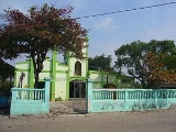
 The Hacienda
Camarón is located to the right of the road from Mexico City
.
It is composed of a courtyard at its center, 50 meters on each side, enclosed by a 3 meter high wall. Two large doors open to the west.
The north section of the structure borders the road and has many rooms for housing, aligned east-to-west.
To the south of the courtyard are found two large storage rooms. The first remains largely intact and forms the supports for the second, situated at a southwest angle to the corral, being nothing but some pieces of wood supported by a brick wall, with a thatched roof. Facing it at a southeast angle are the remains of another storage room. This, with its brick wall, formerly supported the building's frame.
On the south side of the structure, the final storage room has a space through which a person can pass.
Opposite the Hacienda, on the other side of the road, are two condemned houses and the ruins of ten Indian boxes[?].
Veracruz
Veracruz, formally Veracruz de Ignacio de la Llave officially Estado Libre y Soberano de Veracruz de Ignacio de la Llave , is one of the 31 states that, along with the Federal District, comprise the 32 federative entities of Mexico. It is divided in 212 municipalities and its capital city is...
.
It serves as the municipal seat for the surrounding municipality of the same name
Camarón de Tejeda (municipality)
Camarón de Tejeda is one of the 212 municipalities of the Mexican state of Veracruz. It is located in the state's southeast, in the Las Montañas region. The municipal seat is the city of Camarón de Tejeda...
It is most famous for the 1863 Battle of Camarón
Battle of Camarón
The Battle of Camarón, which occurred 30 April 1863 between the French Foreign Legion and the Mexican army, is regarded by the Legion as a defining moment in its history...
at the town's Hacienda Camarón.
In the 2005 INEGI Census, Camarón de Tejeda reported a population of 2,019, with 5,660 in the surrounding municipality.
The area is essentially rural with a population density of 32 people/km². The town is named for the large number of shrimp (camarón in Spanish
Spanish language
Spanish , also known as Castilian , is a Romance language in the Ibero-Romance group that evolved from several languages and dialects in central-northern Iberia around the 9th century and gradually spread with the expansion of the Kingdom of Castile into central and southern Iberia during the...
) found in a small river in the area.
History
Camarón was an ancient Totonaca town called Temaxcal. At the town's haciendaHacienda
Hacienda is a Spanish word for an estate. Some haciendas were plantations, mines, or even business factories. Many haciendas combined these productive activities...
, the Mexican Army
Mexican Army
The Mexican Army is the combined land and air branch and largest of the Mexican Military services; it also is known as the National Defense Army. It is famous for having been the first army to adopt and use an automatic rifle, , in 1899, and the first to issue automatic weapons as standard issue...
triumphed over troops of the French Foreign Legion
French Foreign Legion
The French Foreign Legion is a unique military service wing of the French Army established in 1831. The foreign legion was exclusively created for foreign nationals willing to serve in the French Armed Forces...
in the Battle of Camarón
Battle of Camarón
The Battle of Camarón, which occurred 30 April 1863 between the French Foreign Legion and the Mexican army, is regarded by the Legion as a defining moment in its history...
on 30 April 1863.
After the battle, the words "de Tejeda" were added to the town's name by Mexican Colonel Francisco de Paula Milán to honor pro-Madero
Francisco I. Madero
Francisco Ignacio Madero González was a politician, writer and revolutionary who served as President of Mexico from 1911 to 1913. As a respectable upper-class politician, he supplied a center around which opposition to the dictatorship of Porfirio Díaz could coalesce...
politician Sixto Adalberto Tejeda Olivares (1883-1960), originally of Chicontepec.
Before having its current name, the town was known by several others, including Villa Tejeda in 1927, and Adalberto Tejeda in 1955.
Geography
The town is located in the central part of the Veracruz, at 19° 01’ north latitudeLatitude
In geography, the latitude of a location on the Earth is the angular distance of that location south or north of the Equator. The latitude is an angle, and is usually measured in degrees . The equator has a latitude of 0°, the North pole has a latitude of 90° north , and the South pole has a...
, 96° 37’ west longitude
Longitude
Longitude is a geographic coordinate that specifies the east-west position of a point on the Earth's surface. It is an angular measurement, usually expressed in degrees, minutes and seconds, and denoted by the Greek letter lambda ....
, at an altitude of 320 meters above sea level.
Hacienda Camarón
Hacienda
Hacienda is a Spanish word for an estate. Some haciendas were plantations, mines, or even business factories. Many haciendas combined these productive activities...
Camarón is located to the right of the road from Mexico City
Mexico City
Mexico City is the Federal District , capital of Mexico and seat of the federal powers of the Mexican Union. It is a federal entity within Mexico which is not part of any one of the 31 Mexican states but belongs to the federation as a whole...
.
It is composed of a courtyard at its center, 50 meters on each side, enclosed by a 3 meter high wall. Two large doors open to the west.
The north section of the structure borders the road and has many rooms for housing, aligned east-to-west.
To the south of the courtyard are found two large storage rooms. The first remains largely intact and forms the supports for the second, situated at a southwest angle to the corral, being nothing but some pieces of wood supported by a brick wall, with a thatched roof. Facing it at a southeast angle are the remains of another storage room. This, with its brick wall, formerly supported the building's frame.
On the south side of the structure, the final storage room has a space through which a person can pass.
Opposite the Hacienda, on the other side of the road, are two condemned houses and the ruins of ten Indian boxes[?].