

Calver Hill
Encyclopedia

Yorkshire Dales
The Yorkshire Dales is the name given to an upland area in Northern England.The area lies within the historic county boundaries of Yorkshire, though it spans the ceremonial counties of North Yorkshire, West Yorkshire and Cumbria...
in North Yorkshire
North Yorkshire
North Yorkshire is a non-metropolitan or shire county located in the Yorkshire and the Humber region of England, and a ceremonial county primarily in that region but partly in North East England. Created in 1974 by the Local Government Act 1972 it covers an area of , making it the largest...
, England
England
England is a country that is part of the United Kingdom. It shares land borders with Scotland to the north and Wales to the west; the Irish Sea is to the north west, the Celtic Sea to the south west, with the North Sea to the east and the English Channel to the south separating it from continental...
. It composed of limestone
Limestone
Limestone is a sedimentary rock composed largely of the minerals calcite and aragonite, which are different crystal forms of calcium carbonate . Many limestones are composed from skeletal fragments of marine organisms such as coral or foraminifera....
and is situated at grid reference , near where the valleys of Swaledale
Swaledale
Swaledale is one of the northernmost dales in the Yorkshire Dales National Park in northern England. It is the dale of the River Swale on the east side of the Pennines in North Yorkshire.-Geographical overview:...
and Arkengarthdale
Arkengarthdale
Arkengarthdale is a dale, or valley, on the east side of the Pennines in North Yorkshire, England. Running roughly northwest–southeast, it is the valley of the Arkle Beck, and is the northernmost of the Yorkshire Dales...
meet, the village of Reeth
Reeth
Reeth is a village in the Yorkshire Dales within the Richmondshire district of North Yorkshire, England and principal settlement of Swaledale. It is situated at the meeting point of the two most northerly of the Yorkshire Dales: Swaledale and Arkengarthdale....
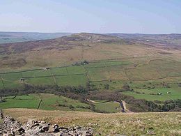
is located on its lower south eastern slopes, it reaches an altitude of 487 metres (1,599 feet) and is a distinguished feature in mid Swaledale. Calver Hill is an area of grouse
Grouse
Grouse are a group of birds from the order Galliformes. They are sometimes considered a family Tetraonidae, though the American Ornithologists' Union and many others include grouse as a subfamily Tetraoninae in the family Phasianidae...
shooting and the fell is dotted with grouse butts. Most of the drainage from the fell goes north and easterly to join the Arkle Beck in lower Arkengarthdale which eventually joins the River Swale just south of Reeth.
Industrial past
Older versions of the 1:25000 Ordnance SurveyOrdnance Survey
Ordnance Survey , an executive agency and non-ministerial government department of the Government of the United Kingdom, is the national mapping agency for Great Britain, producing maps of Great Britain , and one of the world's largest producers of maps.The name reflects its creation together with...
map show a trig point
Trig point
A triangulation station, also known as a triangulation pillar, trigonometrical station, trigonometrical point, trig station, trig beacon or trig point, and sometimes informally as a trig, is a fixed surveying station, used in geodetic surveying and other surveying projects in its vicinity...
at the summit of Calver Hill but all there is now is a pile of rubble and mining spoil to form a summit cairn
Cairn
Cairn is a term used mainly in the English-speaking world for a man-made pile of stones. It comes from the or . Cairns are found all over the world in uplands, on moorland, on mountaintops, near waterways and on sea cliffs, and also in barren desert and tundra areas...
. The fell is littered with signs of Calver Hill’s industrial past; there is a large disused quarry
Quarry
A quarry is a type of open-pit mine from which rock or minerals are extracted. Quarries are generally used for extracting building materials, such as dimension stone, construction aggregate, riprap, sand, and gravel. They are often collocated with concrete and asphalt plants due to the requirement...
500 metres north west of the summit cairn, there are also disused tips, pits and shafts from former lead
Lead
Lead is a main-group element in the carbon group with the symbol Pb and atomic number 82. Lead is a soft, malleable poor metal. It is also counted as one of the heavy metals. Metallic lead has a bluish-white color after being freshly cut, but it soon tarnishes to a dull grayish color when exposed...
mines. Lead mining reached its heyday in the 19th century in this area and they were some of the most productive mines in Yorkshire. Calver Hill was a Bole hill
Bole hill
A Bole hill was a place where lead was formerly smelted in the open air.The bole was usually situated at or near the top of a hill where the wind was strong. Totley Bole Hill on the western fringes of Sheffield consisted of a long low wall with two shorter walls at right angles to it at each end...
a place where the lead from the mines was smelted
Smelting
Smelting is a form of extractive metallurgy; its main use is to produce a metal from its ore. This includes iron extraction from iron ore, and copper extraction and other base metals from their ores...
in an open air furnace which used the prevailing wind to increase the heat. Burnt stones and a scattering of slag
Slag
Slag is a partially vitreous by-product of smelting ore to separate the metal fraction from the unwanted fraction. It can usually be considered to be a mixture of metal oxides and silicon dioxide. However, slags can contain metal sulfides and metal atoms in the elemental form...
show the locations of these furnaces.
Walks
Calver Hill can be climbed from Reeth or from LangthwaiteLangthwaite
Langthwaite is one of the few villages in Arkengarthdale, North Yorkshire, England. It is probably classed as the main settlement in the dale. It is one of the most northerly settlements in the whole of Yorkshire Dales National Park...
and Arkle Town
Arkle Town
Arkle Town is a hamlet adjoining Langthwaite in Arkengarthdale in the Richmondshire district of, North Yorkshire, England. It gets its name from the nearby Arkle Beck. Formerly it had a parish church, inn and workhouse. Now there are none of these....
in Arkengarthdale. From Reeth, Skelgate Lane is taken from just to the west of the village, this climbs through farmland until the open fell is reached at a height of 300 metres, the western ridge is then followed to the summit of the fell. From Arkengarthdale, the Arkle Town to Healaugh bridleway can be used to attain the western ridge at a height of 420 metres; it is then a simple walk to reach the top.