
California State Route 111
Encyclopedia
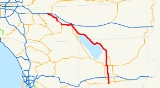
State Route 111 is a state highway
in the U.S. state
of California
. It is the main north/south state highway and retail corridor through the Coachella Valley
, a part of the Colorado Desert
in the southeastern corner of the state and famous as a resort destination. It runs from Calexico
to Interstate 10
at White Water
.
and is eligible for the State Scenic Highway System
. However, this route is not designated by Caltrans as a scenic highway.
First proposed in the early 1930s due to the area's growth bought on by the Southern Pacific Railroad
, Highway 111 links virtually every desert resort city in the valley. It begins at a junction with Interstate 10 near the foot of San Jacinto Peak
east of the San Gorgonio Pass
. This junction was so busy in the 1950s before the construction of the freeway that visitors returning home to Los Angeles might have waited as long as two hours to make the left turn on the two-lane road that was once multiplexed as US Highways 60, 70 and 99. Continuing south, the highway first enters Palm Springs, becoming a surface street. 111 then continues through Cathedral City
, Rancho Mirage
, Palm Desert
, Indian Wells
, La Quinta
, Indio
and finally Coachella
where it is co-signed with State Route 86 before exiting the southeast corner of the valley as a two-lane highway. A 1993 rerouting of the highway takes drivers away from the historic center of Palm Springs, but meets with its original alignment as Business Route 111 a few miles further south.
A nearly 40 mile (64 km) length of the highway dotted with date and citrus groves follows both the old Southern Pacific "Sunset Route" (now the main Union Pacific line between Los Angeles
and Yuma, Arizona
) and the eastern shore of the Salton Sea
. Though some small settlements and a California state park line the shore, the area is eerily empty due to the sea's rapidly declining water quality. The small town of North Shore
is all but abandoned.
As Route 111 continues southward into Imperial County, it passes through the agricultural communities of Niland
, Calipatria
, Brawley
and Holtville
before entering El Centro
. It rejoins 86 in Heber
and terminates in Calexico
at the international border where it meets with Calle State Route 111 in Mexicali
.
As the Coachella Valley's main retail corridor and link to its many resorts, a trip along Route 111 during the height of the tourist season from September to June can be a trying one due to out-of-town traffic, or as the locals fondly refer to them, "snowbirds".
In November 2005, signs on Verbenia Avenue at the highway's northern terminus and along Interstate 10 were replaced to reflect the street's name change to "Haugen-Lehmann Way", honoring two Riverside County sheriff's deputies gunned down by a sniper on that street in 1997.
In a similar move in December 2005, the stretch of SR111 through La Quinta was named the "Deputy Bruce Lee Memorial Highway". Lee was a Riverside County deputy sheriff in the city for many years and was killed in 2003 during an altercation with a mentally disturbed suspect. The suspect was able to take Lee's baton during the altercation and used it to bludgeon the officer.
A 2003 law did not change the route, but clarified that the former highway through those cities could not be taken back by the state, and repealed the section added in 1995 allowing relinquisment to any city. Subsequently, in 2005, the legislature allowed relinquishment within Indian Wells, Indio, and Palm Desert, subject to the same conditions, and to the condition that the cities must maintain signs for the route. La Quinta was added to the list of eligible cities in 2007. As of late 2007, none of these four cities have taken over maintenance of Route 111.
{| class=wikitable
!County
!Location
!Postmile
!Exit
!Destinations
!Notes
|-
|rowspan=13|Imperial
IMP R0.00-65.40
|rowspan=3|Calexico
|R0.00
|colspan=3 align=center|Mexico – United States border
|-
|R0.20
|
|2nd Street – Downtown Calexico
|
|-
|R1.18
|
|, Yuma
|
|-
|
|R4.74
|
|
|
|-
|
|R7.71
|
| – Yuma
, El Centro
, San Diego
|Interchange
|-
|
|9.59
|
|
|
|-
|
|13.08
|
|
|
|-
|
|17.59
|
|
|
|-
|
|bgcolor=#ddffdd|22.14
15.04Indicates that the postmile represents the distance along SR 78
rather than SR 111.
|bgcolor=#ddffdd|
|bgcolor=#ddffdd|
|bgcolor=#ddffdd|South end of SR 78 overlap
|-
|rowspan=2|Brawley
|
|
|Best Road, Old Highway 111
|Old Highway 111 was former SR 111 south
|-bgcolor=#ddffdd
|13.80
22.14
|
|
|North end of SR 78 overlap
|-
|
|26.67
|
|
|
|-
|Calipatria
|32.51
|
|
|
|-
|rowspan=29|Riverside
RIV 0.00-R63.38
|rowspan=2|Mecca
|18.43
|
|
|
|-
|
|
|66th Avenue – Mecca
|
|-
|Thermal
|24.51
|
| Airport Boulevard to SR 86S
|
|-
|rowspan=2|Coachella
|bgcolor=#ddffdd|28.53
20.52Indicates that the postmile represents the distance along SR 86
rather than SR 111.
|bgcolor=#ddffdd|
|bgcolor=#ddffdd|
|bgcolor=#ddffdd|South end of SR 86 overlap
|-bgcolor=#ddffdd
|rowspan=2|
|rowspan=2|
|rowspan=2|, Phoenix
|rowspan=2|South end of I-10 Bus. overlap
|-
|rowspan=4|Indio
|-bgcolor=#ddffdd
|G22.85
28.53
|
|
|North end of SR 86 / I-10 Bus. overlap; former SR 86 north
|-
|28.73
|
|.svg.png) Lorraine Street, Golf Center Parkway to I-10
Lorraine Street, Golf Center Parkway to I-10
|
|-
|30.10
|
|Monroe Street
|
|-
|La Quinta
|34.01
|
|Washington Street
|
|-
|Indian Wells
|37.63
|
|Cook Street
|
|-
|rowspan=3|Palm Desert
|38.64
|
|Portola Avenue
|
|-
|39.57
|
|
|
|-
|rowspan=2|40.80
|rowspan=2 colspan=3 align=center|North end of state maintenance
|-
|rowspan=3|Rancho Mirage
|-
|41.27
|
|Bob Hope Drive
|
|-
|43.35
|
|Country Club Drive
|
|-
|rowspan=2|Cathedral City
|45.39
|
|Date Palm Drive
|
|-
|rowspan=2|47.20
|rowspan=2 colspan=3 align=center|South end of state maintenance
|-
|rowspan=6|Palm Springs
|-
|47.80
T47.80
|
|
|
|-
|T49.37
|
|Ramon Road
|
|-
|T51.59
|
| Vista Chino, Gene Autry Trail to I-10
|
|-
|T52.88
|
|Sunrise Way
|
|-
|T53.94
53.82
|
|
|
|-
|
|
|
|Tipton Road – Whitewater
|
|-
|
|R62.54
|colspan=3 align=center|South end of freeway
|-
|
|bgcolor=#ffdddd|
|bgcolor=#ffdddd|111
|bgcolor=#ffdddd|Haugen-Lehmann Way
|bgcolor=#ffdddd|Northbound exit and southbound entrance
|-
|
|bgcolor=#ffdddd|R63.38
|bgcolor=#ffdddd|
|bgcolor=#ffdddd|
|bgcolor=#ffdddd|Northbound exit and southbound entrance
State highway
State highway, state road or state route can refer to one of three related concepts, two of them related to a state or provincial government in a country that is divided into states or provinces :#A...
in the U.S. state
U.S. state
A U.S. state is any one of the 50 federated states of the United States of America that share sovereignty with the federal government. Because of this shared sovereignty, an American is a citizen both of the federal entity and of his or her state of domicile. Four states use the official title of...
of California
California
California is a state located on the West Coast of the United States. It is by far the most populous U.S. state, and the third-largest by land area...
. It is the main north/south state highway and retail corridor through the Coachella Valley
Coachella Valley
Coachella Valley is a large valley landform in Southern California. The valley extends for approximately 45 miles in Riverside County southeast from the San Bernardino Mountains to the saltwater Salton Sea, the largest lake in California...
, a part of the Colorado Desert
Colorado Desert
California's Colorado Desert is a part of the larger Sonoran Desert, which extends across southwest North America. The Colorado Desert region encompasses approximately , reaching from the Mexican border in the south to the higher-elevation Mojave Desert in the north and from the Colorado River in...
in the southeastern corner of the state and famous as a resort destination. It runs from Calexico
Calexico, California
Calexico is a city in Imperial County, California. The population was 38,572 at the 2010 census, up from 27,109 at the 2000 census. Calexico is about east of San Diego and west of Yuma, Arizona...
to Interstate 10
Interstate 10
Interstate 10 is the fourth-longest Interstate Highway in the United States, after I-90, I-80, and I-40. It is the southernmost east–west, coast-to-coast Interstate Highway, although I-4 and I-8 are further south. It stretches from the Pacific Ocean at State Route 1 in Santa Monica,...
at White Water
White Water, California
Whitewater is a census-designated place in Riverside County, California. It is directly off Interstate 10 halfway between North Palm Springs and Cabazon on the way from Palm Springs to Los Angeles. It is known as the site of the San Gorgonio Pass Wind Farm. The ZIP Code is 92282, and the...
.
Route description
This route is part of the California Freeway and Expressway SystemCalifornia Freeway and Expressway System
The California Freeway and Expressway System is a system of existing or planned freeways and expressways in the U.S. state of California. It is defined by the Streets and Highways Code.-List of roads in the system:*State Route 1 *State Route 2...
and is eligible for the State Scenic Highway System
State Scenic Highway System (California)
The State Scenic Highway System is a list of highways, mainly state highways, that have been designated by the California Department of Transportation as scenic highways. The California State Legislature, primarily through Section 263 of the Streets and Highways Code, makes highways eligible for...
. However, this route is not designated by Caltrans as a scenic highway.
First proposed in the early 1930s due to the area's growth bought on by the Southern Pacific Railroad
Southern Pacific Railroad
The Southern Pacific Transportation Company , earlier Southern Pacific Railroad and Southern Pacific Company, and usually simply called the Southern Pacific or Espee, was an American railroad....
, Highway 111 links virtually every desert resort city in the valley. It begins at a junction with Interstate 10 near the foot of San Jacinto Peak
San Jacinto Peak
San Jacinto Peak, 10,834 feet , is the highest peak of the San Jacinto Mountains, and of Riverside County, California. It lies within Mount San Jacinto State Park...
east of the San Gorgonio Pass
San Gorgonio Pass
The San Gorgonio Pass el. cuts between the San Bernardino Mountains on the north and the San Jacinto Mountains to the south. Like the Cajon Pass to the northwest, it was also created by the San Andreas Fault...
. This junction was so busy in the 1950s before the construction of the freeway that visitors returning home to Los Angeles might have waited as long as two hours to make the left turn on the two-lane road that was once multiplexed as US Highways 60, 70 and 99. Continuing south, the highway first enters Palm Springs, becoming a surface street. 111 then continues through Cathedral City
Cathedral City, California
Cathedral City is a city in Riverside County, California, United States. The population was 51,200 at the 2010 census. Sandwiched between Palm Springs and Rancho Mirage, it is one of the cities in the Coachella Valley of southern California...
, Rancho Mirage
Rancho Mirage, California
Rancho Mirage is a resort city in Riverside County, California, United States. The population was 17,218 at the 2010 census, up from 13,249 at the 2000 census, but the seasonal population can exceed 20,000. In between Cathedral City and Palm Desert, it is one of the eight cities of the Coachella...
, Palm Desert
Palm Desert, California
Palm Desert is a city in Riverside County, California, United States, in the Coachella Valley, approximately east of Palm Springs. The population was 48,445 at the 2010 census, up from 41,155 at the 2000 census...
, Indian Wells
Indian Wells, California
Indian Wells is a city in Riverside County, California, in the Coachella Valley , in between Palm Desert and La Quinta. As of the 2010 census, the city population was 4,958....
, La Quinta
La Quinta, California
La Quinta is a resort city in Riverside County, California, USA, specifically in the Coachella Valley between Indian Wells and Indio. The population was 37,467 at the 2010 census, up from 23,694 at the 2000 census. The Robb Report credits La Quinta as the nation's leading golf destination...
, Indio
Indio, California
Indio is a city in Riverside County, California, United States, located in the Coachella Valley of Southern California's Colorado Desert region. It lies east of Palm Springs, east of Riverside, and east of Los Angeles. It is about north of Mexicali, Baja California on the U.S.-Mexican border...
and finally Coachella
Coachella, California
Coachella is a city in Riverside County, California; it is the easternmost city in the region collectively known as the Coachella Valley...
where it is co-signed with State Route 86 before exiting the southeast corner of the valley as a two-lane highway. A 1993 rerouting of the highway takes drivers away from the historic center of Palm Springs, but meets with its original alignment as Business Route 111 a few miles further south.
A nearly 40 mile (64 km) length of the highway dotted with date and citrus groves follows both the old Southern Pacific "Sunset Route" (now the main Union Pacific line between Los Angeles
Los Angeles, California
Los Angeles , with a population at the 2010 United States Census of 3,792,621, is the most populous city in California, USA and the second most populous in the United States, after New York City. It has an area of , and is located in Southern California...
and Yuma, Arizona
Yuma, Arizona
Yuma is a city in and the county seat of Yuma County, Arizona, United States. It is located in the southwestern corner of the state, and the population of the city was 77,515 at the 2000 census, with a 2008 Census Bureau estimated population of 90,041....
) and the eastern shore of the Salton Sea
Salton Sea
The Salton Sea is a shallow, saline, endorheic rift lake located directly on the San Andreas Fault, predominantly in California's Imperial Valley. The lake occupies the lowest elevations of the Salton Sink in the Colorado Desert of Imperial and Riverside counties in Southern California. Like Death...
. Though some small settlements and a California state park line the shore, the area is eerily empty due to the sea's rapidly declining water quality. The small town of North Shore
North Shore, California
North Shore is a census-designated place in southeastern Riverside County, so named because of its location along the northeast shore of the Salton Sea. It was once a popular vacation destination spot before ever-increasing salinity and pollution of the Salton Sea shut the tourist trade down...
is all but abandoned.
As Route 111 continues southward into Imperial County, it passes through the agricultural communities of Niland
Niland, California
Niland is a census-designated place in Imperial County, California. The town is located north of Calipatria, southeast of Salton Sea. The population was 1,006 at the 2010 census, down from 1,143 at the 2000 census...
, Calipatria
Calipatria, California
Calipatria is a city in Imperial County, California. Calipatria is located north of El Centro, It is part of the El Centro Metropolitan Area. The population was 7,705 at the 2010 census, up from 7,289 at the 2000 census, including 4000 inmates at Calipatria State Prison...
, Brawley
Brawley, California
Brawley is a city in Imperial County, California, United States. Brawley is located north of El Centro. The population was 24,953 at the 2010 census, up from 22,052 at the 2000 census. The town has a significant cattle and feed industry, and hosts the annual Cattle Call Rodeo. Year-round...
and Holtville
Holtville, California
Holtville is a city in Imperial County, California. Holtville is located east of El Centro, The population was 5,939 at the 2010 census, up from 5,612 at the 2000 census. It is part of the 'El Centro, California, Metropolitan Statistical Area'...
before entering El Centro
El Centro, California
El Centro is a city in and county seat of Imperial County, the largest city in the Imperial Valley and the east anchor of the Southern California Border Region, and the core urban area and principal city of the El Centro metropolitan area which encompasses all of Imperial County. El Centro is also...
. It rejoins 86 in Heber
Heber, California
Heber is a census-designated place in Imperial County, California. Heber is located north-northwest of Calexico. The population was 4,275 at the 2010 census, up from 2,566 at the 2000 census.-Geography:Heber is located at ....
and terminates in Calexico
Calexico, California
Calexico is a city in Imperial County, California. The population was 38,572 at the 2010 census, up from 27,109 at the 2000 census. Calexico is about east of San Diego and west of Yuma, Arizona...
at the international border where it meets with Calle State Route 111 in Mexicali
Mexicali
Mexicali is the capital of the State of Baja California, seat of the Municipality of Mexicali, and 2nd largest city in Baja California. The City of Mexicali has a population of 689,775, according to the 2010 census, while the population of the entire metropolitan area reaches 936,826.The city...
.
As the Coachella Valley's main retail corridor and link to its many resorts, a trip along Route 111 during the height of the tourist season from September to June can be a trying one due to out-of-town traffic, or as the locals fondly refer to them, "snowbirds".
In November 2005, signs on Verbenia Avenue at the highway's northern terminus and along Interstate 10 were replaced to reflect the street's name change to "Haugen-Lehmann Way", honoring two Riverside County sheriff's deputies gunned down by a sniper on that street in 1997.
In a similar move in December 2005, the stretch of SR111 through La Quinta was named the "Deputy Bruce Lee Memorial Highway". Lee was a Riverside County deputy sheriff in the city for many years and was killed in 2003 during an altercation with a mentally disturbed suspect. The suspect was able to take Lee's baton during the altercation and used it to bludgeon the officer.
History
In 1995, Caltrans was allowed to relinquish any portion of Route 111 through a city for that city to maintain. The legislature opted to make the act an "urgency statute", effective immediately, so that the local governments could improve traffic bottlenecks along the route as soon as possible. The legislative definition of the route was amended in 1996 to exclude the portions in Rancho Mirage and Cathedral City, which had both been relinquished. Cathedral City completed a pedestrian-friendly redesign in 1998. The stretch through Rancho Mirage has the Coachella Valley's only synchronized traffic lights; they are set to 45 mph (70 km/h).A 2003 law did not change the route, but clarified that the former highway through those cities could not be taken back by the state, and repealed the section added in 1995 allowing relinquisment to any city. Subsequently, in 2005, the legislature allowed relinquishment within Indian Wells, Indio, and Palm Desert, subject to the same conditions, and to the condition that the cities must maintain signs for the route. La Quinta was added to the list of eligible cities in 2007. As of late 2007, none of these four cities have taken over maintenance of Route 111.
Major intersections
- Note: Except where prefixed with a letter, postmiles were measured in 1964, based on the alignment as it existed at that time, and do not necessarily reflect current mileage. The numbers reset at county lines; the start and end postmiles in each county are given in the county column.
{| class=wikitable
!County
!Location
!Postmile
!Exit
Exit number
An exit number is a number assigned to a road junction, usually an exit from a freeway. It is usually marked on the same sign as the destinations of the exit, as well as a sign in the gore....
!Destinations
!Notes
|-
|rowspan=13|Imperial
Imperial County, California
Imperial County is a county located in the Imperial Valley, in the far southeast of the U.S. state of California, bordering both Arizona and Mexico. It is part of the El Centro Metropolitan Area, which encompasses all of Imperial County. The population as of 2000 was 142,361. The county seat is the...
IMP R0.00-65.40
|rowspan=3|Calexico
Calexico, California
Calexico is a city in Imperial County, California. The population was 38,572 at the 2010 census, up from 27,109 at the 2000 census. Calexico is about east of San Diego and west of Yuma, Arizona...
|R0.00
|colspan=3 align=center|Mexico – United States border
|-
|R0.20
|
|2nd Street – Downtown Calexico
|
|-
|R1.18
|
|, Yuma
Yuma, Arizona
Yuma is a city in and the county seat of Yuma County, Arizona, United States. It is located in the southwestern corner of the state, and the population of the city was 77,515 at the 2000 census, with a 2008 Census Bureau estimated population of 90,041....
|
|-
|
|R4.74
|
|
|
|-
|
|R7.71
|
| – Yuma
Yuma, Arizona
Yuma is a city in and the county seat of Yuma County, Arizona, United States. It is located in the southwestern corner of the state, and the population of the city was 77,515 at the 2000 census, with a 2008 Census Bureau estimated population of 90,041....
, El Centro
El Centro, California
El Centro is a city in and county seat of Imperial County, the largest city in the Imperial Valley and the east anchor of the Southern California Border Region, and the core urban area and principal city of the El Centro metropolitan area which encompasses all of Imperial County. El Centro is also...
, San Diego
San Diego, California
San Diego is the eighth-largest city in the United States and second-largest city in California. The city is located on the coast of the Pacific Ocean in Southern California, immediately adjacent to the Mexican border. The birthplace of California, San Diego is known for its mild year-round...
|Interchange
|-
|
|9.59
|
|
|
|-
|
|13.08
|
|
|
|-
|
|17.59
|
|
|
|-
|
|bgcolor=#ddffdd|22.14
15.04Indicates that the postmile represents the distance along SR 78
California State Route 78
State Route 78 is a state highway in the U.S. state of California in the United States that runs from Oceanside east to Blythe, traversing nearly the entire width of the state. Its western terminus is at Interstate 5 in San Diego County and its eastern terminus is at I-10 in Riverside County...
rather than SR 111.
|bgcolor=#ddffdd|
|bgcolor=#ddffdd|
|bgcolor=#ddffdd|South end of SR 78 overlap
|-
|rowspan=2|Brawley
Brawley, California
Brawley is a city in Imperial County, California, United States. Brawley is located north of El Centro. The population was 24,953 at the 2010 census, up from 22,052 at the 2000 census. The town has a significant cattle and feed industry, and hosts the annual Cattle Call Rodeo. Year-round...
|
|
|Best Road, Old Highway 111
|Old Highway 111 was former SR 111 south
|-bgcolor=#ddffdd
|13.80
22.14
|
|
|North end of SR 78 overlap
|-
|
|26.67
|
|
|
|-
|Calipatria
Calipatria, California
Calipatria is a city in Imperial County, California. Calipatria is located north of El Centro, It is part of the El Centro Metropolitan Area. The population was 7,705 at the 2010 census, up from 7,289 at the 2000 census, including 4000 inmates at Calipatria State Prison...
|32.51
|
|
|
|-
|rowspan=29|Riverside
Riverside County, California
Riverside County is a county in the U.S. state of California. One of 58 California counties, it covers in the southern part of the state, and stretches from Orange County to the Colorado River, which forms the state border with Arizona. The county derives its name from the city of Riverside,...
RIV 0.00-R63.38
|rowspan=2|Mecca
Mecca, California
Mecca is a census-designated place in Riverside County, California, United States. The population was 8,577 at the 2010 census, up from 5,402 at the 2000 census....
|18.43
|
|
|
|-
|
|
|66th Avenue – Mecca
Mecca, California
Mecca is a census-designated place in Riverside County, California, United States. The population was 8,577 at the 2010 census, up from 5,402 at the 2000 census....
|
|-
|Thermal
Thermal, California
Thermal is a census-designated place located approximately 25 miles southeast of Palm Springs and about 9.5 miles north of the Salton Sea. Although one can find sunny skies most days, residents occasionally endure strong winds and sizzling summer temperatures well above 100 degrees Fahrenheit. The...
|24.51
|
|
|
|-
|rowspan=2|Coachella
Coachella, California
Coachella is a city in Riverside County, California; it is the easternmost city in the region collectively known as the Coachella Valley...
|bgcolor=#ddffdd|28.53
20.52Indicates that the postmile represents the distance along SR 86
California State Route 86
State Route 86 is a north–south state highway in the southeastern desert region of Southern California, United States. It runs from State Route 111, near the Mexican border crossing at Calexico, north through the Imperial Valley via El Centro and Brawley, and around the west side of the...
rather than SR 111.
|bgcolor=#ddffdd|
|bgcolor=#ddffdd|
|bgcolor=#ddffdd|South end of SR 86 overlap
|-bgcolor=#ddffdd
|rowspan=2|
|rowspan=2|
|rowspan=2|, Phoenix
Phoenix, Arizona
Phoenix is the capital, and largest city, of the U.S. state of Arizona, as well as the sixth most populated city in the United States. Phoenix is home to 1,445,632 people according to the official 2010 U.S. Census Bureau data...
|rowspan=2|South end of I-10 Bus. overlap
|-
|rowspan=4|Indio
Indio, California
Indio is a city in Riverside County, California, United States, located in the Coachella Valley of Southern California's Colorado Desert region. It lies east of Palm Springs, east of Riverside, and east of Los Angeles. It is about north of Mexicali, Baja California on the U.S.-Mexican border...
|-bgcolor=#ddffdd
|G22.85
28.53
|
|
|North end of SR 86 / I-10 Bus. overlap; former SR 86 north
|-
|28.73
|
|
|
|-
|30.10
|
|Monroe Street
|
|-
|La Quinta
La Quinta, California
La Quinta is a resort city in Riverside County, California, USA, specifically in the Coachella Valley between Indian Wells and Indio. The population was 37,467 at the 2010 census, up from 23,694 at the 2000 census. The Robb Report credits La Quinta as the nation's leading golf destination...
|34.01
|
|Washington Street
|
|-
|Indian Wells
Indian Wells, California
Indian Wells is a city in Riverside County, California, in the Coachella Valley , in between Palm Desert and La Quinta. As of the 2010 census, the city population was 4,958....
|37.63
|
|Cook Street
|
|-
|rowspan=3|Palm Desert
Palm Desert, California
Palm Desert is a city in Riverside County, California, United States, in the Coachella Valley, approximately east of Palm Springs. The population was 48,445 at the 2010 census, up from 41,155 at the 2000 census...
|38.64
|
|Portola Avenue
|
|-
|39.57
|
|
|
|-
|rowspan=2|40.80
|rowspan=2 colspan=3 align=center|North end of state maintenance
|-
|rowspan=3|Rancho Mirage
Rancho Mirage, California
Rancho Mirage is a resort city in Riverside County, California, United States. The population was 17,218 at the 2010 census, up from 13,249 at the 2000 census, but the seasonal population can exceed 20,000. In between Cathedral City and Palm Desert, it is one of the eight cities of the Coachella...
|-
|41.27
|
|Bob Hope Drive
|
|-
|43.35
|
|Country Club Drive
|
|-
|rowspan=2|Cathedral City
Cathedral City, California
Cathedral City is a city in Riverside County, California, United States. The population was 51,200 at the 2010 census. Sandwiched between Palm Springs and Rancho Mirage, it is one of the cities in the Coachella Valley of southern California...
|45.39
|
|Date Palm Drive
|
|-
|rowspan=2|47.20
|rowspan=2 colspan=3 align=center|South end of state maintenance
|-
|rowspan=6|Palm Springs
Palm Springs, California
Palm Springs is a desert city in Riverside County, California, within the Coachella Valley. It is located approximately 37 miles east of San Bernardino, 111 miles east of Los Angeles and 136 miles northeast of San Diego...
|-
|47.80
T47.80
|
|
|
|-
|T49.37
|
|Ramon Road
|
|-
|T51.59
|
|
|
|-
|T52.88
|
|Sunrise Way
|
|-
|T53.94
53.82
|
|
|
|-
|
|
|
|Tipton Road – Whitewater
|
|-
|
|R62.54
|colspan=3 align=center|South end of freeway
|-
|
|bgcolor=#ffdddd|
|bgcolor=#ffdddd|111
|bgcolor=#ffdddd|Haugen-Lehmann Way
|bgcolor=#ffdddd|Northbound exit and southbound entrance
|-
|
|bgcolor=#ffdddd|R63.38
|bgcolor=#ffdddd|
|bgcolor=#ffdddd|
|bgcolor=#ffdddd|Northbound exit and southbound entrance