
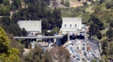
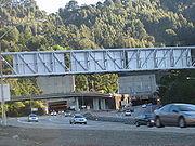
Caldecott Tunnel
Encyclopedia
Tunnel
A tunnel is an underground passageway, completely enclosed except for openings for egress, commonly at each end.A tunnel may be for foot or vehicular road traffic, for rail traffic, or for a canal. Some tunnels are aqueducts to supply water for consumption or for hydroelectric stations or are sewers...
between Oakland, California
Oakland, California
Oakland is a major West Coast port city on San Francisco Bay in the U.S. state of California. It is the eighth-largest city in the state with a 2010 population of 390,724...
and Contra Costa County, California
Contra Costa County, California
Contra Costa County is a primarily suburban county in the San Francisco Bay Area of the U.S. state of California. As of the 2010 census, it had a population of 1,049,025...
. The east-west tunnel is signed as a part of State Route 24
California State Route 24
State Route 24 in the U.S. state of California is a heavily-traveled east–west freeway in the eastern side of the San Francisco Bay Area of northern California that runs from the Interstate 580/Interstate 980 interchange in Oakland to the Interstate 680 junction in Walnut Creek...
, which is also known as the William Byron Rumford
William Byron Rumford
William Byron Rumford was an American pharmacist and politician. He was the first African American elected to any public office in Northern California.-Family background:...
Freeway from Interstate 580 to Walnut Creek, and connects Oakland to bedroom communities
Commuter town
A commuter town is an urban community that is primarily residential, from which most of the workforce commutes out to earn their livelihood. Many commuter towns act as suburbs of a nearby metropolis that workers travel to daily, and many suburbs are commuter towns...
in Contra Costa County
Contra Costa County, California
Contra Costa County is a primarily suburban county in the San Francisco Bay Area of the U.S. state of California. As of the 2010 census, it had a population of 1,049,025...
, through the Berkeley Hills
Berkeley Hills
The Berkeley Hills are a range of the Pacific Coast Ranges that overlook the northeast side of the valley that surrounds San Francisco Bay. They were previously called the "Contra Costa Range/Hills" , but with the establishment of Berkeley and the University of California, the current usage was...
. (The name of the freeway was the Grove-Shafter Freeway until 1980, when it was named after Rumford.) The tunnel is named after Thomas E. Caldecott
Thomas E. Caldecott
Thomas Edwin Caldecott was a politician in Alameda County, California in the San Francisco Bay Area in the first half of the 20th century. The Caldecott Tunnel which is a key highway link through the Berkeley Hills is named after him....
(1878–1951), mayor of Berkeley
Berkeley, California
Berkeley is a city on the east shore of the San Francisco Bay in Northern California, United States. Its neighbors to the south are the cities of Oakland and Emeryville. To the north is the city of Albany and the unincorporated community of Kensington...
from 1930–1932, member of the Alameda County Board of Supervisors 1933-1945, and president of Joint Highway District 13, which built the first two bores.
Bore 1 (the southernmost bore) and Bore 2 were completed in 1937 and are each 3,610 feet (1,100 m) long and carry two lanes of traffic. Bore 3 (the northernmost bore), built in 1964, is 3,771 feet (1,149 m) in length, and also carries two traffic lanes.
The middle bore (Bore 2) can be shifted
Reversible lane
A reversible lane , called a counterflow lane or contraflow lane in transport engineering nomenclature, is a lane in which traffic may travel in either direction, depending on certain conditions...
to accommodate heavy traffic. Generally, it carries westbound traffic from about midnight to noon and eastbound traffic from about noon to midnight.
Construction of a fourth bore began in January 2010. Cost of construction is estimated at $400 million, of which the American Recovery and Reinvestment Act
American Recovery and Reinvestment Act of 2009
The American Recovery and Reinvestment Act of 2009, abbreviated ARRA and commonly referred to as the Stimulus or The Recovery Act, is an economic stimulus package enacted by the 111th United States Congress in February 2009 and signed into law on February 17, 2009, by President Barack Obama.To...
will provide $280 million.
History
In the 19th century, traffic over the Berkeley HillsBerkeley Hills
The Berkeley Hills are a range of the Pacific Coast Ranges that overlook the northeast side of the valley that surrounds San Francisco Bay. They were previously called the "Contra Costa Range/Hills" , but with the establishment of Berkeley and the University of California, the current usage was...
in this area went up Harwood Canyon, now known as Claremont Canyon (behind the Claremont Hotel
Claremont Resort
The Claremont Hotel Club & Spa is a historic hotel at the foot of Claremont Canyon in the Berkeley Hills, providing the resort with scenic views of San Francisco Bay. The hotel building is entirely in Oakland, bordering Berkeley....
). The road leading up the canyon from the west was initially called Harwood's Road, later changed to Telegraph Road
Telegraph Avenue
Telegraph Avenue is a street that begins, at its southernmost point, in the midst of the historic downtown district of Oakland, California, USA, and ends, at its northernmost point, at the southern edge of the University of California campus in Berkeley, California...
, and finally, Claremont. The road on the other side of the hills was, and remains Fish Ranch Road. An inn once existed at the summit.
The idea of a tunnel through the hills began as early as 1860. In that year, the idea was proposed and rejected by the citizens of Alameda and Contra Costa Counties. It was revived in 1871 with a proposal which described a route running from the end of Broadway, similar to the actual routing of today's Caldecott Tunnel although it is not clear from the description exactly which canyon was being referred to. The proposed tunnel would be only some 500 feet long and would have its outlet in the San Pablo Creek watershed with a road leading into Lafayette. A franchise was granted to a group of developers who passed the franchise onto another group. The proposal languished until the turn of the century.
In 1903 a tunnel was finally built above the present location of the Caldecott Tunnel, in the next canyon south of Claremont Canyon. This tunnel was approached by a new road dubbed "Tunnel Road" which started at the top of Ashby Avenue in Berkeley
Berkeley, California
Berkeley is a city on the east shore of the San Francisco Bay in Northern California, United States. Its neighbors to the south are the cities of Oakland and Emeryville. To the north is the city of Albany and the unincorporated community of Kensington...
. The west end of the tunnel was at about 37.8561°N 122.2137°W
In 1929 construction of the first two bores of the Caldecott Tunnel began. They were completed in 1937, and were originally known as the Broadway Low Level Tunnel as the approach was from the top of Broadway in Oakland, and was below the portal of the old tunnel. However, access from Ashby Avenue was retained as it was designated the connecting thoroughfare from the Eastshore Highway (now Freeway) and the San Francisco – Oakland Bay Bridge, and dubbed State Highway 24. The approach to the east portal on the other side of the Berkeley Hills was via Mount Diablo Blvd., also at that time part of State Highway 24.
The third bore opened in 1964. In the late 1960s the Grove-Shafter Freeway was completed and replaced Broadway as the main route to the Caldecott Tunnel from Oakland as well as replacing Ashby for traffic coming from San Francisco. Ashby Avenue and Tunnel Road were redesignated State Highway 13
State Route 13 (California)
State Route 13 is a state highway in California. It is a short loop in Alameda County currently built from Interstate 580 in Oakland to Interstate 80/Interstate 580 in Berkeley....
and aligned with the new Warren Freeway through the Montclair District of Oakland. The Grove-Shafter Freeway was then designated State Highway 24.
On 7 April 1982, an accident involving a gasoline truck in the north bore set off the Caldecott Tunnel fire
Caldecott Tunnel fire
The Caldecott Tunnel fire killed seven people in the north tube of the Caldecott Tunnel, on State Route 24 between Oakland and Orinda in the US state of California just after midnight on 7 April 1982...
. The accident caused major damage, and the bore was closed to traffic while repairs were made. During the fire, the tunnel acted as a natural chimney venting the smoke, flames and heat toward the east side entrance to the tunnel. The accident and fire killed seven people. It occurred shortly after midnight when there were few cars in the tunnel. If it had occurred during normal commute hours, hundreds could have died. As a result of the fire, it is now illegal to transport hazardous material in a tank truck through the tunnel except between the light traffic hours of 3:00 a.m. to 5:00 a.m.
In October 1991 the catastrophic Oakland firestorm
1991 Oakland firestorm
The Oakland Firestorm of 1991 was a large urban fire that occurred on the hillsides of northern Oakland, California, and southeastern Berkeley on Sunday October 20, 1991, two years after the Loma Prieta earthquake...
started on the ridge north of the Caldecott Tunnel. The fire spread quickly west down both sides of the west portal of the tunnel on its way to killing 25 and destroying over three thousand homes, apartments and condominiums.
In 2000 the California Department of Transportation
California Department of Transportation
The California Department of Transportation is a government department in the U.S. state of California. Its mission is to improve mobility across the state. It manages the state highway system and is actively involved with public transportation systems throughout the state...
began planning for a fourth bore.
The Caldecott Tunnel was designated a City of Oakland Landmark in 1980, and received a Preservation Award from the Art Deco Society of California in 1993.
On February 28, 2007, the California Transportation Commission approved the final funding needed to build the fourth bore.
On July 26, 2007 a car broke out into flames and 2 of the 3 bores were closed down.
On February 14, 2010 construction of the fourth bore began with the removal of trees at the site of the future east and west portals.
Weather phenomena
Weather conditions can vary greatly from one end of the tunnel to the other. In summer, for example, motorists may enter the tunnel from the east where it is sunny and warm, and emerge on the west end into fog and cold. In winter, during spells of inland tule fogTule fog
Tule fog is a thick ground fog that settles in the San Joaquin Valley and Sacramento Valley areas of California's Great Central Valley. Tule fog forms during the late fall and winter after the first significant rainfall. The official time frame for tule fog to form is from November 1 to March 31...
, the reverse can occur.
On a sunny day, it may be well over 90° at the east portal, due to the inland nature, while a more coastal-like 70° on the Oakland side.