

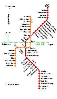
Cairo Metro
Encyclopedia
The Cairo Metro in Egypt
is the first of only two full-fledged metro
system in Africa
, and the Arab World
. The system consists of two operational lines, with construction having begun on a third line in 2006.
The metro is run by the National Authority for Tunnels. The lines use standard gauge
(1435 mm). The ticket price is EGP
1.00 for each journey (about GBP 0.12, EUR
0.14, or USD
0.18, average exchange rate for May 2010), regardless of distance. On all Cairo
metro trains, the middle two cars (4th and 5th) of each train are reserved for women (the 5th car becomes a mixed use after 21:00). These cars are used as an option for women who do not wish to ride with men in the same car; however, women can still ride other cars freely.
The two lines carry around 700 million passengers a year and on average 2 million per day.
 As the biggest and most densely populated city in Africa
, and the Arab World
, the case for a metro in Cairo was strong. In 1987 that population stood at 10 million residents, not counting the two million or so commuters who came into Cairo every day to work. The capacity of Cairo's public transport infrastructure was around 20,000 passengers/hour, which increased to 60,000 after the construction of the Metro. In 1990 a study was conducted for the future needs of the city and showed there was a need for about 8.4 million journeys by public transport and 2.7 million journeys by other modes, such as taxi and car. The actual public transport capacity is 4.9 million journeys/day, 3.5 million short of the actual requirement. This has led to a 50% increase in the number of taxis on the streets with subsequent increases in traffic congestion in the city.
 The idea of a metro was first thought of in the 1930s by the Egyptian engineer Saiyed Abdel Wahed who was working at the Egyptian Railway Authority, however, the idea did not progress. Following the Egyptian Revolution of 1952, there was renewed interest in the idea. In 1954 French experts made a report about the future of the transportation in Egypt. They proposed a metro encompassing two lanes, one 12 km long lane connecting Bab al-Louq
and Ismailia
and a second 5 km lane connecting Boulaq
and Abou al-Ela Castle. They also proposed that there should be one company in charge of all transportation systems.
Later on multiple experts came to Egypt regarding that project: Soviet experts in 1956, Japanese
experts in 1960 and French experts in 1962, which concluded the following:
The creation of a metro system with multiple lines. The first is a 5 km lane connecting Helwan with El-Marg
going under the Kasr el eini street and Ramses Street. The second lane would be from Sayeda Zainab to Shobra
going under Downtown Cairo
and would be 9.5 km long. The third is from Giza to Abbasiyah and would be 11.5 km long. The fourth is from Al Awqaf to the Castle and is 6.7 km long.
In 1964 British experts advised the creation of a metro line from Bab El Louk to Shubra. In 1966 Japanese experts advised the creation of a lane between Helwan and El Marg and another one going through Mohandessin
, Heliopolis
and 26 of July street, which would encompass 26 km. Lastly, in 1969, the government approved the need for a study showing the needed capacity for Cairo's transportation system. The Egyptian Ministry of Transport had an international tender
for the creation of the study. Eight companies applied and the French company Sufreto won the tender on 20 September 1970. The study was finished in 1973 and included mainly the study of the population development in Cairo and its needs for transportation capacity in 1980,1985 and 1990. It concluded the necessity for three lines in greater Cairo to solve the transportation problem.
The first line would use the already available railways (Helwan-Bab El luk and Al Laymoun Bridge- El Marg) and connect them through a metro. It would be in total 43 km long. The second line should be 13.5 km and connect Shubra El-Kheima and Bulak el Dakrur going through Ramses Street and Tahrir Square. The third line would go from El Darasa to Imbaba
and would be in total 10 km long.
The priority for the project was the first line which would reduce 30% of the daily transport to and from Cairo and use the already available structures. The detailed study of the construction took 6 years from 1975 to 1981. A tender was made for the construction of the metro and the Egyptian-French company Entra Nevra Arabco won it and had the task of constructing the metro system.
 The construction of the project started in 1982 after the French government agreed on giving Egypt the necessary loan. The first Helwan - El Marg line costs 1107 million francs which were converted into EGP
and divided into multiple stages. The total cost of the first stage from Helwan to Ramses is 473.9 million EGP
divided into the following:
The second stage cost a total of 499.6 million EGP and connected the (Laymoun Bridge - El Marg) railway with the metro. Additional costs were made available as requested by the ministry of transportation:
The first stage was from Helwan to Sayeda Zenab and included an underground tunnel from Helwan to Ramses Square.
First the line from Helwan to Sayeda Zenab, which is 24 km long had the following construction works:
Second the line from Helwan to Ramses Square, which would be a subterranean and is 4.5 km long. It includes five subterranean stations after the Sayeda Zenab station:
The Construction of this line consumed the following resources:
In 1987 the line from Helwan to Ramses Square was finished and opened for the public. It had a total length of 29 km.
The second stage of the Helwan - El Marg line included the construction of a line from Ramses Square to El Marg, which would be 14 km long. The operation of the line was aimed for 1988, but due to some difficulties it started operation in 1989.
The second stage included also:
The contract was awarded to a consortium led by Vinci Construction Grand Projects, a French construction company. Vinci Construction, which holds a 28.5% stake in the consortium, was given the civil engineering package of the contract in January 2007. Other parties in the consortium include Arab Contractors (27.5% stake), Bouygues (26%) and local company Orascom Construction Industries that has been awarded 18% of the contract.
Cairo's metro network was greatly expanded in the mid-1990s with the building of Line 2 (yellow), from Shoubra El Kheima to Cairo University
, with an extension to Giza.
It is the first line in history to have a tunnel going under the Nile
.
The tunnel under the Nile is 8.35 m in internal diameter and was constructed using two Herenknecht bentonite slurry shield TBMs
, which are 9.43 m in diameter. Extending 21.5 kilometres (13 mi) with 20 stations, it is sometimes called the "Japanese-Built Line". It is mostly in bored tunnel, with two exceptions: a short section at the northern end approaching Shubra El Kheima which is elevated, and a section just south of this by cut-and-cover. The main difference between Lines 1 and 2 is that Line 1 uses an overhead line while Line 2 uses the third-rail system. The construction of the line was finished in October 2000 and was later extended to El Mounib. The communication extension for line 2 was provided by Alcatel in 2005.
. The line crosses under the two branches of the River Nile, as does Line 2. The total length of the line is approximately 33 kilometres (21 mi) most of which is in bored tunnel and will be implemented in four phases. The project includes a main workshop adjacent to the western terminal of the line and a light repair workshop at the middle of the line at Abbasia.
The implementation of Line No. 3 will start with Attaba to Abbasia section, the first phase, followed by the second phase from Abbasia to Heliopolis, which are the most urgent sections for the transportation needs.
The design of phase 1 is taking into consideration the safe crossing of two major underground structures; namely, the line 2 bored tunnel at Attaba and the wastewater spine tunnel north of Attaba. It is also planned that some of the underground stations will be extensively used as commercial centres. These stations will be constructed by the cut-and-cover method and the rolling stock will be fed by power through a third rail. Orascom Construction Industries won the tender for 1 billion EGP for the construction of the first phase of the project. The line will have a contactless fare collection system
and integrated supervision and communication system supplied by the Thales Group
.
France provided a 280 million dollar loan for the second phase of the project to french companies involved in the project.
Phase 1 is currently underconstruction with a total length of 4.3 kilometres starts from Attaba to Abbasiyya in which five stations are being built and dug as of June 2011. They are Attaba, Bab El-sha'eria, El Geish, Abdo Basha and Al Abbasiyya. El Geish street has been closed since May 2008 for underground works. Works underground at the Attaba station have been running since 2007 to divert water pipes, electricity grid and sewage network. Work in that station which also serves Line 2 will begin in early 2009.
Phase 1 has a completion and operational date set at October 2011 but is pushed back to January 2012 due to the recently uprising events and from October 2011 till January 2012 operational tests will be conducted.
Phase 2 construction work on Line 3 has begun in mid-2009 and will run from Abbassiya Station till Al Ahram Station in Heliopolis
, with four stations to be constructed, Cairo Fairground, The Stadium, Koleyet El-Banat, and Al-Ahram. This phase has a completion date set at October 2013.
Phase 3 is set to begin in 2011 and it is the western branch of Line 3, this phase will connect Attaba Station with the already existing Gamal Abdel Nasser Station through Emad El-Din Street with a new station built in between, it will then continue on its way onto Maspero
(New Station) and run under both branches of the Nile passing through Zamalek
island and ending at Sphinx Square Station.
Completion date is set at October 2015.
Phase 4 is scheduled to begin in 2013 will be starting from Sphinx Square Station it will split into two branches with on heading towards Imbaba and the other toward Mohandessin
with two stations on the Imbama branch (Kit Kat Station and Sudan Street Station) and three stations on the Mohandessin branch (Mustafa Mahmoud Station, Shehab Street Station and Lebanon Square Station).
This phase is set for a completion date of October 2017.
Phase 5 which is the final phase in Line 3 has a starting date set at 2015 with a plan for it to continue where it originally left off on the Eastern side of the line completing its path toward Cairo International Airport
, running through Heliopolis Square and Ain Shams district, with seven stations to be constructed.
Line 3 is expected to be fully operational by October 2019.
literally connecting Greater Cairo from West to East.
Phase 1 of the project will run from El-Malek El-Saleh Station (Interchange with Line 1) all the way to the October-Oasis Highway Station with a total length of 17 km, passing through Giza Railways Station (Interchange with Line 2); the original plan for phase 1 was for it to start from EL-Malek El-Saleh Station and end at the Grand Egyptian Museum
Station with a total length of 10 km but the Ministry of Roads & Transportation decided to extend the Line in their efforts to further connect the Governorate of 6 October to the Greater Cairo
Area; phase 1 also includes the plan to connect the end of Line 4 to the suburbs of 6 October mainly through executing The October 6th Tram system (The O6T) which will be by using a Tram-train
system supplied with the Alstom
Regio-Citadis
trams.
As of September 2009, Japan International Cooperation Agency
(JICA) is currently finalizing the feasibility study of the line, with construction expected to begin early 2011. Phase 1 is likely to be operational right after the completion of the 3rd phase in Line 3 by October 2016.
Phase 2 construction of Line 4 is set to begin in 2014 starting from El-Malek El-Saleh Station passing through Magra El-Oyoun street and Salah El-Din Citadel in Salah Salem street and ending at the 6th District Station (beginning of Nasr City
district) with a completion date set at October 2018.
Phase 3 construction of Line 4 is set to begin in 2015 starting from the 6th District Station and ending at Makram Ebeid Station running through Mustafa El-Nahas street in bored tunnels under the existing old tram system, taking it as a guide and ultimately deconstructing the old railway and paving the path it occupied increasing the street by two lanes in each direction which is critically needed to lighten the traffic congestion in the area.
This phase has a completion date set at October 2019.
Phase 4 which is also the final phase of construction work in Line 4 has a starting date set in 2017 where it will start from Makram Ebeid Station with bored tunnels running through Doctor Hassan El-Sherif street and all the way under Ahmed El-Zomor street reaching the end of the line and making it complete at the Mubarak Police Academy Station.
Line 4 is expected to be fully operational by October 2020.
from north to south starting at the Cairo International Airport
and ending at the beginning of the Cairo-Ain Sokhna Highway, where the government is currently planning to build a major bus station to serve those traveling to the eastern part of the country.
The project has an estimated cost of $750 million and a completion date set at 2020.
Proposed stations:
 A transportation study of the Greater Cairo region was completed in 1999. It recommended the implementation of a six line system consisting of lines 1 and 2 (existing), Line 3 (under construction as of 2010); and lines 4, 5 and 6. The completed Metro Network would be capable of serving most of the densely populated areas in the Greater Cairo region, which was much in need of a comprehensive mass transit system. The plans include interchange stations between the six metro lines and would also provides interchange facilities with existing main railway stations, the airport, and bus stations.
The six planned metro lines aim to meet the transportation demands of the Greater Cairo area up to the year 2022. However, the actual construction and implementation schedule will be restricted by available funding, and it is likely that the timetable will slip.
Line 5 would be half-circular line connecting lines 1, 2, 3 and 4, running from Nasr City to Port Said Street and Shubra El Kheima. It would have a length of 20 kilometres (12 mi), entirely within bored tunnels.
Line 6 would stretch from Shubra in the north until the Maadi
and Helwan districts in the south. It would run from Ataba Station (Interchange with both Line 2 and Line 3) through El Kalaa street in bored tunnels to Salah Eldin Citadel Station (Interchange with Line 4) and moving on from there to both districts via bored tunnels using the existing route El-Mahager Railway as a guide through both Maadi and Helwan. This Line has a length of 19 kilometres (12 mi),
Egypt
Egypt , officially the Arab Republic of Egypt, Arabic: , is a country mainly in North Africa, with the Sinai Peninsula forming a land bridge in Southwest Asia. Egypt is thus a transcontinental country, and a major power in Africa, the Mediterranean Basin, the Middle East and the Muslim world...
is the first of only two full-fledged metro
Rapid transit
A rapid transit, underground, subway, elevated railway, metro or metropolitan railway system is an electric passenger railway in an urban area with a high capacity and frequency, and grade separation from other traffic. Rapid transit systems are typically located either in underground tunnels or on...
system in Africa
Africa
Africa is the world's second largest and second most populous continent, after Asia. At about 30.2 million km² including adjacent islands, it covers 6% of the Earth's total surface area and 20.4% of the total land area...
, and the Arab World
Arab world
The Arab world refers to Arabic-speaking states, territories and populations in North Africa, Western Asia and elsewhere.The standard definition of the Arab world comprises the 22 states and territories of the Arab League stretching from the Atlantic Ocean in the west to the Arabian Sea in the...
. The system consists of two operational lines, with construction having begun on a third line in 2006.
The metro is run by the National Authority for Tunnels. The lines use standard gauge
Standard gauge
The standard gauge is a widely-used track gauge . Approximately 60% of the world's existing railway lines are built to this gauge...
(1435 mm). The ticket price is EGP
Egyptian pound
The Egyptian Pound is the currency of Egypt. It is divided into 100 Qirsh , or 1,000 Milliemes ....
1.00 for each journey (about GBP 0.12, EUR
Euro
The euro is the official currency of the eurozone: 17 of the 27 member states of the European Union. It is also the currency used by the Institutions of the European Union. The eurozone consists of Austria, Belgium, Cyprus, Estonia, Finland, France, Germany, Greece, Ireland, Italy, Luxembourg,...
0.14, or USD
United States dollar
The United States dollar , also referred to as the American dollar, is the official currency of the United States of America. It is divided into 100 smaller units called cents or pennies....
0.18, average exchange rate for May 2010), regardless of distance. On all Cairo
Cairo
Cairo , is the capital of Egypt and the largest city in the Arab world and Africa, and the 16th largest metropolitan area in the world. Nicknamed "The City of a Thousand Minarets" for its preponderance of Islamic architecture, Cairo has long been a centre of the region's political and cultural life...
metro trains, the middle two cars (4th and 5th) of each train are reserved for women (the 5th car becomes a mixed use after 21:00). These cars are used as an option for women who do not wish to ride with men in the same car; however, women can still ride other cars freely.
The two lines carry around 700 million passengers a year and on average 2 million per day.
Cairo's need for a Metro
Africa
Africa is the world's second largest and second most populous continent, after Asia. At about 30.2 million km² including adjacent islands, it covers 6% of the Earth's total surface area and 20.4% of the total land area...
, and the Arab World
Arab world
The Arab world refers to Arabic-speaking states, territories and populations in North Africa, Western Asia and elsewhere.The standard definition of the Arab world comprises the 22 states and territories of the Arab League stretching from the Atlantic Ocean in the west to the Arabian Sea in the...
, the case for a metro in Cairo was strong. In 1987 that population stood at 10 million residents, not counting the two million or so commuters who came into Cairo every day to work. The capacity of Cairo's public transport infrastructure was around 20,000 passengers/hour, which increased to 60,000 after the construction of the Metro. In 1990 a study was conducted for the future needs of the city and showed there was a need for about 8.4 million journeys by public transport and 2.7 million journeys by other modes, such as taxi and car. The actual public transport capacity is 4.9 million journeys/day, 3.5 million short of the actual requirement. This has led to a 50% increase in the number of taxis on the streets with subsequent increases in traffic congestion in the city.
Proposed plans
Bab al-Louq
Bab al-Louq is a neighborhood in downtown Cairo. The Egyptian Ministry of Interior is located here....
and Ismailia
Ismaïlia
-Notable natives:*Osman Ahmed Osman, a famous and influential Egyptian engineer, contractor, entrepreneur, and politician, was born in this town on 6 April 1917....
and a second 5 km lane connecting Boulaq
Boulaq
Boulaq is a district of Cairo, Egypt. It neighbours Downtown Cairo, Azbakeya, and the River Nile.The name Boulaq comes from the French 'Bon Lac', which literally means 'Good Lake'. The name was arabised into Bolaq, which in Egyptian dialect is pronounced 'Bolaa'.-History:Following the Baybars’s...
and Abou al-Ela Castle. They also proposed that there should be one company in charge of all transportation systems.
Later on multiple experts came to Egypt regarding that project: Soviet experts in 1956, Japanese
Japanese people
The are an ethnic group originating in the Japanese archipelago and are the predominant ethnic group of Japan. Worldwide, approximately 130 million people are of Japanese descent; of these, approximately 127 million are residents of Japan. People of Japanese ancestry who live in other countries...
experts in 1960 and French experts in 1962, which concluded the following:
The creation of a metro system with multiple lines. The first is a 5 km lane connecting Helwan with El-Marg
El-Marg
El-Marg is a district in the north-east of Cairo. It was separated from Al-Salam district as of 1 April 1994. The district is crowded, holding approximately 610,000 residents. Residents only occupy an area of 7.71 km2, while the area of the district is 41.96 km2.- References :* ' -...
going under the Kasr el eini street and Ramses Street. The second lane would be from Sayeda Zainab to Shobra
Shobra
Shubra is one of the largest districts of Cairo, Egypt and it is administratively divided into three areas: Shubra, Road El Farag, and Elsahel.-Etymology:...
going under Downtown Cairo
Downtown Cairo
Downtown Cairo, , has been the urban center of Cairo, Egypt since the late 19th century, when the district was designed and built.-History:The area, designed by prestigious French architects was commissioned by Khedive Ismail...
and would be 9.5 km long. The third is from Giza to Abbasiyah and would be 11.5 km long. The fourth is from Al Awqaf to the Castle and is 6.7 km long.
In 1964 British experts advised the creation of a metro line from Bab El Louk to Shubra. In 1966 Japanese experts advised the creation of a lane between Helwan and El Marg and another one going through Mohandessin
Mohandessin
Mohandessin , could also be spelled Mohandesin or Mohandeseen, is an up-scale neighborhood in Giza. Its name means in Arab literally the engineers, which was because it was given to at cheaper prices to engineers in Egypt; there is a similar area in Mohandesin called Sahafeyeen , mo'alemeen , and...
, Heliopolis
Heliopolis (Cairo Suburb)
Modern Heliopolis is a district in Cairo, Egypt. The city was established in 1905 by the Heliopolis Oasis Company, headed by the Belgian industrialist Édouard Louis Joseph, Baron Empain, as well as Boghos Nubar, son of the Egyptian Prime Minister Nubar Pasha.-History:The Baron Empain, a well known...
and 26 of July street, which would encompass 26 km. Lastly, in 1969, the government approved the need for a study showing the needed capacity for Cairo's transportation system. The Egyptian Ministry of Transport had an international tender
Request for tender
A request for tender, commonly abbreviated to RFT, is a formal, structured invitation to suppliers for the supply of products or services. In the public sector, such a process may be required and determined in detail by law to ensure that such competition for the use of public money is open, fair...
for the creation of the study. Eight companies applied and the French company Sufreto won the tender on 20 September 1970. The study was finished in 1973 and included mainly the study of the population development in Cairo and its needs for transportation capacity in 1980,1985 and 1990. It concluded the necessity for three lines in greater Cairo to solve the transportation problem.
The first line would use the already available railways (Helwan-Bab El luk and Al Laymoun Bridge- El Marg) and connect them through a metro. It would be in total 43 km long. The second line should be 13.5 km and connect Shubra El-Kheima and Bulak el Dakrur going through Ramses Street and Tahrir Square. The third line would go from El Darasa to Imbaba
Imbaba
Imbaba is a neighbourhood in northern Cairo, Egypt, located west of the Nile and northwest of and near Gezira Island and downtown Cairo, within the Giza Governorate...
and would be in total 10 km long.
The priority for the project was the first line which would reduce 30% of the daily transport to and from Cairo and use the already available structures. The detailed study of the construction took 6 years from 1975 to 1981. A tender was made for the construction of the metro and the Egyptian-French company Entra Nevra Arabco won it and had the task of constructing the metro system.
Line 1 (Helwan - El Marg)
Cairo Metro Line 1 is the first line of the Cairo Metro. Its first stage was opened to the public in 1987 and it was fully completed in 1989 connecting Helwan with El Marg and consisting of 33 stations with a total length of 43 km, of which 4.5 km are underground. The line witnessed few developments since 1989, New El Marg station was added in 1999 to the northern end of the line, bringing its total length to 44.3 km. Helwan University station was built between Wadi Houf and Ain Helwan stations. The line now consists of 35 stations. This line carries trains with 3 Units (9 wagons), which have a time difference of 2.5 minutes and a maximum speed of 100 km/h. The line can carry 60,000 passengers per hour in each direction.Costs
Egyptian pound
The Egyptian Pound is the currency of Egypt. It is divided into 100 Qirsh , or 1,000 Milliemes ....
and divided into multiple stages. The total cost of the first stage from Helwan to Ramses is 473.9 million EGP
EGP
EGP may refer to:*Edinburgh Global Partnerships, a student-run charity*Egyptian pound, the currency of Egypt*Ejército Guerrillero de los Pobres *European Green Party, a political party...
divided into the following:
- 397 million EGP for the tunnel between Saiyeda Zenab and Ramses with a length of 4.7 km.
- 74.5 million EGP for the movement of 60 km different structures and the improvement of the older railways.
- 2.4 million EGP for the creation of a station in Dar El Salam.
The second stage cost a total of 499.6 million EGP and connected the (Laymoun Bridge - El Marg) railway with the metro. Additional costs were made available as requested by the ministry of transportation:
- 172.8 million EGP for completing the (Ramses - El Marg) lane.
- 280 million EGP for the third stage of the (Helwan - E Marg) lane.
- 400 million EGP for the (Shubra El Kheima - Ramses - El Tahrir) lane
- 2 million EGP for the preparation study of the second lane Imbaba - El Darasa
Construction
The Construction of the Helwan - El Marg line was in two stages.The first stage was from Helwan to Sayeda Zenab and included an underground tunnel from Helwan to Ramses Square.
First the line from Helwan to Sayeda Zenab, which is 24 km long had the following construction works:
- The isolation of the existing railways and the construction of 9 car bridges and 21 people bridges.
- The construction of 17 rail lane switcher.
- The renovation of the existing railways.
- The production of 882 km of Cables which satisfy the needs of the rail way from Helwan to Sayeda Zenab.
Second the line from Helwan to Ramses Square, which would be a subterranean and is 4.5 km long. It includes five subterranean stations after the Sayeda Zenab station:
- Saad Zaghloul station
- Sadat station
- Gamal Abdel NasserGamal Abdel NasserGamal Abdel Nasser Hussein was the second President of Egypt from 1956 until his death. A colonel in the Egyptian army, Nasser led the Egyptian Revolution of 1952 along with Muhammad Naguib, the first president, which overthrew the monarchy of Egypt and Sudan, and heralded a new period of...
station - Ahmed Orabi station
- Martyrs of the Revolution of the 25th station (formerly the MubarakHosni MubarakMuhammad Hosni Sayyid Mubarak is a former Egyptian politician and military commander. He served as the fourth President of Egypt from 1981 to 2011....
station) under Ramses Square
The Construction of this line consumed the following resources:
- 117,000 cubic metres of concrete works.
- 334,550 cubic metres of digging works.
- 3900 concrete walls
- 3800 metres other digging works.
In 1987 the line from Helwan to Ramses Square was finished and opened for the public. It had a total length of 29 km.
The second stage of the Helwan - El Marg line included the construction of a line from Ramses Square to El Marg, which would be 14 km long. The operation of the line was aimed for 1988, but due to some difficulties it started operation in 1989.
The second stage included also:
- The conversion of El Marg line to an electric line.
- The acquisition of 48 new units, which would make 100 units available for operation.
- The improvement of a workstation to provide maintenance works for 204 Units.
- The construction of a 220 kilo-VoltVoltThe volt is the SI derived unit for electric potential, electric potential difference, and electromotive force. The volt is named in honor of the Italian physicist Alessandro Volta , who invented the voltaic pile, possibly the first chemical battery.- Definition :A single volt is defined as the...
power generator, to provide electricity for the future lines.
The contract was awarded to a consortium led by Vinci Construction Grand Projects, a French construction company. Vinci Construction, which holds a 28.5% stake in the consortium, was given the civil engineering package of the contract in January 2007. Other parties in the consortium include Arab Contractors (27.5% stake), Bouygues (26%) and local company Orascom Construction Industries that has been awarded 18% of the contract.
Line 2 (Shobra El Kheima - El Mounib)
Cairo Metro Line 2 is the second line of the Cairo Metro.Cairo's metro network was greatly expanded in the mid-1990s with the building of Line 2 (yellow), from Shoubra El Kheima to Cairo University
Cairo University
Cairo University is a public university located in Giza, Egypt.The university was founded on December 21, 1908, as the result of an effort to establish a national center for educational thought...
, with an extension to Giza.
It is the first line in history to have a tunnel going under the Nile
Nile
The Nile is a major north-flowing river in North Africa, generally regarded as the longest river in the world. It is long. It runs through the ten countries of Sudan, South Sudan, Burundi, Rwanda, Democratic Republic of the Congo, Tanzania, Kenya, Ethiopia, Uganda and Egypt.The Nile has two major...
.
The tunnel under the Nile is 8.35 m in internal diameter and was constructed using two Herenknecht bentonite slurry shield TBMs
Tunnel boring machine
A tunnel boring machine also known as a "mole", is a machine used to excavate tunnels with a circular cross section through a variety of soil and rock strata. They can bore through anything from hard rock to sand. Tunnel diameters can range from a metre to almost 16 metres to date...
, which are 9.43 m in diameter. Extending 21.5 kilometres (13 mi) with 20 stations, it is sometimes called the "Japanese-Built Line". It is mostly in bored tunnel, with two exceptions: a short section at the northern end approaching Shubra El Kheima which is elevated, and a section just south of this by cut-and-cover. The main difference between Lines 1 and 2 is that Line 1 uses an overhead line while Line 2 uses the third-rail system. The construction of the line was finished in October 2000 and was later extended to El Mounib. The communication extension for line 2 was provided by Alcatel in 2005.
- October 1996 Shobra - Mubarak, 8 kilometres (5 mi)
- Sept 1998: Mubarak - Sadat, 3 kilometres (2 mi)
- April 19, 1999: Sadat - Cairo University, 5.5 kilometres (3 mi) (including crossing of the Nile)
- October 8, 2000: Cairo University - Giza Suburban 2.7 kilometres (2 mi)
- January 17, 2005: Giza Suburban - Mounib 2.5 kilometres (2 mi)
Line 3 (Imbaba / Mohandiseen - Cairo Int'l Airport)
Cairo Metro Line 3 (under construction) extends from the northwest of the Greater Cairo at Imbaba to the northeast at Heliopolis and will eventually also serve Cairo International AirportCairo International Airport
Cairo International Airport is the busiest airport in Egypt and the primary hub for Star Alliance member EgyptAir. The airport is located to the north-east of the city around from the business area of the city.The airport is administered by the Egyptian Holding Co...
. The line crosses under the two branches of the River Nile, as does Line 2. The total length of the line is approximately 33 kilometres (21 mi) most of which is in bored tunnel and will be implemented in four phases. The project includes a main workshop adjacent to the western terminal of the line and a light repair workshop at the middle of the line at Abbasia.
The implementation of Line No. 3 will start with Attaba to Abbasia section, the first phase, followed by the second phase from Abbasia to Heliopolis, which are the most urgent sections for the transportation needs.
The design of phase 1 is taking into consideration the safe crossing of two major underground structures; namely, the line 2 bored tunnel at Attaba and the wastewater spine tunnel north of Attaba. It is also planned that some of the underground stations will be extensively used as commercial centres. These stations will be constructed by the cut-and-cover method and the rolling stock will be fed by power through a third rail. Orascom Construction Industries won the tender for 1 billion EGP for the construction of the first phase of the project. The line will have a contactless fare collection system
Proximity card
Proximity card is a generic name for contactless integrated circuit devices used for security access or payment systems. The standard can refer to the older 125 kHz devices or the newer 13.56 MHz contactless RFID cards, most commonly known as contactless smartcards.Modern proximity cards...
and integrated supervision and communication system supplied by the Thales Group
Thales Group
The Thales Group is a French electronics company delivering information systems and services for the aerospace, defense, transportation and security markets...
.
France provided a 280 million dollar loan for the second phase of the project to french companies involved in the project.
Phase 1 is currently underconstruction with a total length of 4.3 kilometres starts from Attaba to Abbasiyya in which five stations are being built and dug as of June 2011. They are Attaba, Bab El-sha'eria, El Geish, Abdo Basha and Al Abbasiyya. El Geish street has been closed since May 2008 for underground works. Works underground at the Attaba station have been running since 2007 to divert water pipes, electricity grid and sewage network. Work in that station which also serves Line 2 will begin in early 2009.
Phase 1 has a completion and operational date set at October 2011 but is pushed back to January 2012 due to the recently uprising events and from October 2011 till January 2012 operational tests will be conducted.
Phase 2 construction work on Line 3 has begun in mid-2009 and will run from Abbassiya Station till Al Ahram Station in Heliopolis
Heliopolis (Cairo Suburb)
Modern Heliopolis is a district in Cairo, Egypt. The city was established in 1905 by the Heliopolis Oasis Company, headed by the Belgian industrialist Édouard Louis Joseph, Baron Empain, as well as Boghos Nubar, son of the Egyptian Prime Minister Nubar Pasha.-History:The Baron Empain, a well known...
, with four stations to be constructed, Cairo Fairground, The Stadium, Koleyet El-Banat, and Al-Ahram. This phase has a completion date set at October 2013.
Phase 3 is set to begin in 2011 and it is the western branch of Line 3, this phase will connect Attaba Station with the already existing Gamal Abdel Nasser Station through Emad El-Din Street with a new station built in between, it will then continue on its way onto Maspero
Maspero
People with the name Maspero include:*Gaston Maspero , French Egyptologist, father of Henri*Henri Maspero , French sinologist, son of Gaston, father of François*François Maspero , French author and journalist, son of Henri...
(New Station) and run under both branches of the Nile passing through Zamalek
Zamalek
Zamalek Sporting Club , is an Egyptian sporting club based in Meet Okba, Giza, Egypt that plays in the Egyptian Premier League....
island and ending at Sphinx Square Station.
Completion date is set at October 2015.
Phase 4 is scheduled to begin in 2013 will be starting from Sphinx Square Station it will split into two branches with on heading towards Imbaba and the other toward Mohandessin
Mohandessin
Mohandessin , could also be spelled Mohandesin or Mohandeseen, is an up-scale neighborhood in Giza. Its name means in Arab literally the engineers, which was because it was given to at cheaper prices to engineers in Egypt; there is a similar area in Mohandesin called Sahafeyeen , mo'alemeen , and...
with two stations on the Imbama branch (Kit Kat Station and Sudan Street Station) and three stations on the Mohandessin branch (Mustafa Mahmoud Station, Shehab Street Station and Lebanon Square Station).
This phase is set for a completion date of October 2017.
Phase 5 which is the final phase in Line 3 has a starting date set at 2015 with a plan for it to continue where it originally left off on the Eastern side of the line completing its path toward Cairo International Airport
Cairo International Airport
Cairo International Airport is the busiest airport in Egypt and the primary hub for Star Alliance member EgyptAir. The airport is located to the north-east of the city around from the business area of the city.The airport is administered by the Egyptian Holding Co...
, running through Heliopolis Square and Ain Shams district, with seven stations to be constructed.
Line 3 is expected to be fully operational by October 2019.
Line 4 (October-Oasis Highway - the Police Academy)
Cairo Metro Line 4 (Construction to begin early 2011) is planned to run from Haram District reaching the New Cairo districtliterally connecting Greater Cairo from West to East.
Phase 1 of the project will run from El-Malek El-Saleh Station (Interchange with Line 1) all the way to the October-Oasis Highway Station with a total length of 17 km, passing through Giza Railways Station (Interchange with Line 2); the original plan for phase 1 was for it to start from EL-Malek El-Saleh Station and end at the Grand Egyptian Museum
Grand Egyptian Museum
The Grand Egyptian Museum , also known as the Giza Museum, is a planned museum of artifacts of ancient Egypt. Described as the largest archaeological museum in the world, the USD 550 million museum is scheduled to open in 2013...
Station with a total length of 10 km but the Ministry of Roads & Transportation decided to extend the Line in their efforts to further connect the Governorate of 6 October to the Greater Cairo
Greater Cairo
Greater Cairo is the largest metropolitan area in Egypt and the third largest urban area in the Islamic World after Jakarta and Greater Istanbul. It is the largest urban area in Africa. It is the world's 16th largest metropolitan area, consisting of governorates Cairo, Giza and Shubra El Khiema of...
Area; phase 1 also includes the plan to connect the end of Line 4 to the suburbs of 6 October mainly through executing The October 6th Tram system (The O6T) which will be by using a Tram-train
Tram-train
A tram-train is a light-rail public transport system where trams run both on an urban tramway network and on main-line railways to combine the tram's flexibility and availability and the train's greater speed...
system supplied with the Alstom
Alstom
Alstom is a large multinational conglomerate which holds interests in the power generation and transport markets. According to the company website, in the years 2010-2011 Alstom had annual sales of over €20.9 billion, and employed more than 85,000 people in 70 countries. Alstom's headquarters are...
Regio-Citadis
Citadis
The Citadis is a low-floor tram built by Alstom in La Rochelle, France, and Barcelona, Spain. 1,140 Citadis are currently in use in 28 cities, among others: Bordeaux, Grenoble, Lyon, Montpellier, Orléans, the Paris area, and Barcelona, Dublin, Gdańsk, Katowice, Adelaide, Melbourne, Jerusalem and...
trams.
As of September 2009, Japan International Cooperation Agency
Japan International Cooperation Agency
The Japan International Cooperation Agency is an independent governmental agency that coordinates official development assistance for the government of Japan...
(JICA) is currently finalizing the feasibility study of the line, with construction expected to begin early 2011. Phase 1 is likely to be operational right after the completion of the 3rd phase in Line 3 by October 2016.
Phase 2 construction of Line 4 is set to begin in 2014 starting from El-Malek El-Saleh Station passing through Magra El-Oyoun street and Salah El-Din Citadel in Salah Salem street and ending at the 6th District Station (beginning of Nasr City
Nasr City
Nasr City is a district of Cairo, Egypt. It is located to the east of the Cairo Governorate and consists mostly of condominiums. It was established in the 1960s as an extension to neighboring suburb of Heliopolis. The establishment of the district was part of the Egyptian Government's plan to...
district) with a completion date set at October 2018.
Phase 3 construction of Line 4 is set to begin in 2015 starting from the 6th District Station and ending at Makram Ebeid Station running through Mustafa El-Nahas street in bored tunnels under the existing old tram system, taking it as a guide and ultimately deconstructing the old railway and paving the path it occupied increasing the street by two lanes in each direction which is critically needed to lighten the traffic congestion in the area.
This phase has a completion date set at October 2019.
Phase 4 which is also the final phase of construction work in Line 4 has a starting date set in 2017 where it will start from Makram Ebeid Station with bored tunnels running through Doctor Hassan El-Sherif street and all the way under Ahmed El-Zomor street reaching the end of the line and making it complete at the Mubarak Police Academy Station.
Line 4 is expected to be fully operational by October 2020.
The New Cairo Monorail
This project has been proposed by private investors and awaiting approval from the government with a plan to connect Line 3 with Line 4 through a route which is mostly parallel to the Ring Road's eastern arc, therefore covering New CairoNew Cairo
New Cairo is a new satellite city of Cairo. Located in what was formerly desert, the master plan was created in 2001 by a Boston firm. It is the home of the new campus of the American University in Cairo, as well as the German University in Cairo, the Future University in Egypt and the Canadian...
from north to south starting at the Cairo International Airport
Cairo International Airport
Cairo International Airport is the busiest airport in Egypt and the primary hub for Star Alliance member EgyptAir. The airport is located to the north-east of the city around from the business area of the city.The airport is administered by the Egyptian Holding Co...
and ending at the beginning of the Cairo-Ain Sokhna Highway, where the government is currently planning to build a major bus station to serve those traveling to the eastern part of the country.
The project has an estimated cost of $750 million and a completion date set at 2020.
Proposed stations:
- Cairo International Airport مطار القاهرة الدولي
- The Governmental Complex مجمع الهيئات الحكومية
- Naguib Mahfouz نجيب محفوظ
- Mubarak Police Academy أكاديمية مبارك للأمن
- The 5th Settlement التجمع الخامس
- Katameya القطامية
- Eastern Cairo Bus Station ميناء شرق العاصمة البري
Plans
The six planned metro lines aim to meet the transportation demands of the Greater Cairo area up to the year 2022. However, the actual construction and implementation schedule will be restricted by available funding, and it is likely that the timetable will slip.
Line 5 would be half-circular line connecting lines 1, 2, 3 and 4, running from Nasr City to Port Said Street and Shubra El Kheima. It would have a length of 20 kilometres (12 mi), entirely within bored tunnels.
Line 6 would stretch from Shubra in the north until the Maadi
Maadi
Maadi is a wealthy suburb south of Cairo, Egypt. The town is home to the Supreme Constitutional Court of Egypt, Cairo American College , Lycée Français du Caire , Misr American College , Maadi British International School , the Cairo Rugby Club, and the national Egyptian Geological Museum.-...
and Helwan districts in the south. It would run from Ataba Station (Interchange with both Line 2 and Line 3) through El Kalaa street in bored tunnels to Salah Eldin Citadel Station (Interchange with Line 4) and moving on from there to both districts via bored tunnels using the existing route El-Mahager Railway as a guide through both Maadi and Helwan. This Line has a length of 19 kilometres (12 mi),
External links
- Cairo Metro
- Some hi-res pictures from inside the Cairo Metro
- National Authority for Tunnels official website
- Cairo Metro on UrbanRail.Net
- The Greater Cairo Metro Network (International Tunnelling Association)
- Cairo Metro Stations Chart in English (VirtualTourist.com)