
Cachoeira Dourada
Encyclopedia
| Cachoeira Dourada | |
|---|---|
| State | Goiás Goiás Goiás is a state of Brazil, located in the central part of the country. The name Goiás comes from the name of an indigenous community... |
| Coordinates: | 18°29′44"S 49°28′04"W |
| Area: | 521.1 km² |
| Population: | 7,567 (IBGE 2007) |
| Elevation: | 459 m above sea level |
| Postcode (CEP): | 75560-000 |
| Became a city: | 1982 |
| Mayor: | Lauro Vinicius Ramos |
| Distance to Goiânia Goiânia -Climate:The city has a tropical wet and dry climate with an average temperature of . There's a wet season, from October to April, and a dry one, from May to September. Annual rainfall is around 1,520 mm.... : |
234 km. |
| IBGE statistical microregion: | Meia Ponte Microregion Meia Ponte Microregion The Meia Ponte Microregion is a statistical region of Goiás state, Brazil created by the IBGE . It is located south of the state capital, Goiânia, and includes 21 cities with a total population of 338,147 inhabitants . The total area is 21,229.00 km² and the population density is 14.39 inhab/km²... |
| Website: | none |
Town
A town is a human settlement larger than a village but smaller than a city. The size a settlement must be in order to be called a "town" varies considerably in different parts of the world, so that, for example, many American "small towns" seem to British people to be no more than villages, while...
and municipality
Municipality
A municipality is essentially an urban administrative division having corporate status and usually powers of self-government. It can also be used to mean the governing body of a municipality. A municipality is a general-purpose administrative subdivision, as opposed to a special-purpose district...
in south-central Goiás
Goiás
Goiás is a state of Brazil, located in the central part of the country. The name Goiás comes from the name of an indigenous community...
state, Brazil
Brazil
Brazil , officially the Federative Republic of Brazil , is the largest country in South America. It is the world's fifth largest country, both by geographical area and by population with over 192 million people...
. The population was 7,567 (2007) in a total area of 521.1 km².
Geographical Information
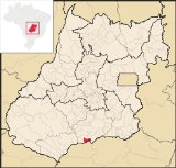
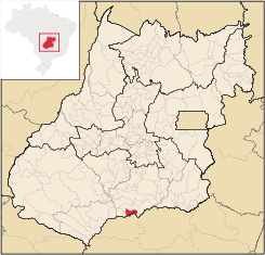
The municipality of Cachoeira Dourada is located in the extreme south of GoiásGoiás
Goiás is a state of Brazil, located in the central part of the country. The name Goiás comes from the name of an indigenous community...
at a distance of 258 kilometers from the state capital, Goiânia
Goiânia
-Climate:The city has a tropical wet and dry climate with an average temperature of . There's a wet season, from October to April, and a dry one, from May to September. Annual rainfall is around 1,520 mm....
. It lies on the banks of the Paranaíba
Paranaíba River
The Paranaíba River is a Brazilian river whose source lies in the state of Minas Gerais in the Mata da Corda mountains, municipality of Rio Paranaíba, at an altitude of 1,148 meters; on the other face of this mountain chain are the sources of the Abaeté river, tributary of the São Francisco River...
and is 31 kilometers southwest of the important city of Itumbiara
Itumbiara
Itumbiara is a small city and municipality in the extreme south of the state of Goiás, Brazil. The population was 100,000 in a total area of 2,461,3 km²...
. It is part of the geographical microregion designated Meia Ponte Microregion
Meia Ponte Microregion
The Meia Ponte Microregion is a statistical region of Goiás state, Brazil created by the IBGE . It is located south of the state capital, Goiânia, and includes 21 cities with a total population of 338,147 inhabitants . The total area is 21,229.00 km² and the population density is 14.39 inhab/km²...
.
There are boundaries on the north and east with Itumbiara
Itumbiara
Itumbiara is a small city and municipality in the extreme south of the state of Goiás, Brazil. The population was 100,000 in a total area of 2,461,3 km²...
, on the south with the Paranaíba, and on the west with Inaciolândia
Inaciolândia
Inaciolândia is a small town and municipality in south Goiás state, Brazil. The population was 5,650 inhabitants in a total area of 688.3 km². Inaciolândia is a large producer of cotton and soybeans.-Geographical Information:...
. The main access routes are GO-260, GO-153, GO-452, MG-154 and MG-365.
The distance to state capital, Goiânia
Goiânia
-Climate:The city has a tropical wet and dry climate with an average temperature of . There's a wet season, from October to April, and a dry one, from May to September. Annual rainfall is around 1,520 mm....
, is 228 km. Highway connections from Goiânia
Goiânia
-Climate:The city has a tropical wet and dry climate with an average temperature of . There's a wet season, from October to April, and a dry one, from May to September. Annual rainfall is around 1,520 mm....
are made by BR-153 / Aparecida de Goiânia
Aparecida de Goiânia
Aparecida de Goiânia is a city and municipality in central Goiás, Brazil. It is the second largest city in the state and a bustling industrial center.-Location:...
/ Professor Jamil
Professor Jamil
Professor Jamil is a small town and municipality in south-central Goiás state, Brazil. The population was 3,298 in a total area of 347.4 km²...
/ Serrinha
Serrinha
Serrinha is a Bahian city with 71,383 people. The mayor is Tania de Freitas Motas Lomes of the Brazilian Social Democracy Party.The city is the seat of the Roman Catholic Diocese of Serrinha.- External links :*...
(district) / Itumbiara
Itumbiara
Itumbiara is a small city and municipality in the extreme south of the state of Goiás, Brazil. The population was 100,000 in a total area of 2,461,3 km²...
/ BR-452 / GO-206 / BR-483. Source for distances: Sepin
Besides the municipal seat there were the hamlets (Povoados) of Almeirindonópolis, Nilópolis, Pontezinha and Vila Operária da Celg.
Demographic and political facts
- Population density in 2007: 14.52 inhab/km²
- Population growth rate 1996/2007: -0.76.%
- Total population in 2007: 7,567
- Total population in 1991: 8,502
- Urban population in 2007: 5,085
- Rural population in 2007: 2,482
- City government in 2005: mayor (Lauro Vinicius Ramos), vice-mayor (José Dantas da Silva), and 09 councilmembers
(Sepin/IBGE)
Cachoeira Dourada was first made a district of Itumbiara
Itumbiara
Itumbiara is a small city and municipality in the extreme south of the state of Goiás, Brazil. The population was 100,000 in a total area of 2,461,3 km²...
in 1962, becoming a municipality in 1982
Economic activities
The main economic activities are cattle raising (34,190 in 2006), agriculture, and the hydroelectric energy plant. Cotton, corn, and soybeans are the most important crops.- Retail establishments: 100 in 2007
- Industrial establishments: 09
- Financial institutions: 03—HSBC, Banco do Brasil S.A., Banco Multiplo
- Dairies: Miqueline Ltda.
(Sepin/IBGE)
Planted Area of Main Crops (2006)
- Rice: 500 ha.
- Corn: 4,000 ha.
- Bananas: 80 ha.
- Beans: 120 ha.
- Soybeans: 4,700 ha.
- Cotton: 680 ha. (Sepin)
Farm Data (2006)
- Farms: 157
- Total area: 31,630 ha.
- Area of permanent crops: 132 ha.
- Area of perennial crops: 9,013 ha.
- Area of natural pasture: 19,073 ha.
- Persons dependent on farming: 600
- Farms with tractors: 92
- Number of tractors: 177 IBGE
Health (2007)
- Infant mortality rate in 2000: 16.68
- Infant mortality rate in 1990: 29.47
- Total health units: 04
- Hospitals: 01 with 16 beds
(Sepin/IBGE)
Education (2006)
- Literacy rate in 2000: 82.6
- Literacy rate in 1991: 73.2
- Schools: 08 with 2,667 students
(Sepin/IBGE)
Ranking on the Municipal Human Development Index
- MHDI: 0.759
- State ranking: 56 (out of 242 municipalities)
- National ranking: 1,603 (out of 5,507 municipalities)
(Frigoletto)
Tourism
In tourism, the artificial lake formed by the Itumbiara DamItumbiara Dam
The Itumbiara Dam is an embankment dam on the Paranaíba River near Itumbiara in Goiás, Brazil. The dam serves an associated hydroelectric power plant with a 2,082 MW installed capacity...
on the Paranaíba is the main attraction. The lake is navigable between Cachoeira Dourada and Itumbiara, a distance of 64 kilometers. The region has springs of hot, salty water, a unique phenomenon in the country. This water is consumed for its reputed therapeutic qualities.