
Butler County, Kansas
Encyclopedia
Butler County is a county located in South Central Kansas
, in the Central
United States
. As of the 2010 census, the county population was 65,880. Its county seat
and most populous city is El Dorado
. The county is a part of the Wichita
Metropolitan Statistical Area
.
.
In 1877, the Florence, El Dorado, and Walnut Valley Railroad Company built a branch line from Florence
to El Dorado
, in 1881 it was extended to Douglass
, and later to Arkansas City
. The line was leased and operated by the Atchison, Topeka and Santa Fe Railway
. The line from Florence
to El Dorado
was abandoned in 1942. The original branch line connected Florence
, Burns
, De Graff, El Dorado
, Augusta
, Douglass
, Rock
, Akron, Winfield
, Arkansas City
.
In 1887, the Chicago, Kansas and Nebraska Railway built a branch line north-south from Herington
to Caldwell
. This branch line connected Herington
, Lost Springs
, Lincolnville
, Antelope
, Marion
, Aulne
, Peabody
, Elbing
, Whitewater
, Furley
, Kechi
, Wichita
, Peck
, Corbin
, Wellington
, Caldwell
. By 1893, this branch line was incrementally built to Fort Worth, Texas
. This line is called the "OKT". The Chicago, Kansas and Nebraska Railway was foreclosed in 1891 and was taken over by Chicago, Rock Island and Pacific Railway, which shut down in 1980 and reorganized as Oklahoma, Kansas and Texas Railroad
, merged in 1988 with Missouri Pacific Railroad
, and finally merged in 1997 with Union Pacific Railroad
. Most locals still refer to this railroad as the "Rock Island".
(Phase II) was constructed north to south through Butler County (near Potwin
, Towanda
, Augusta
, Douglass
), with much controversy over tax exemption and environmental concerns (if a leak ever occurs). A pumping station named Burns was built 2 miles north of Potwin
, and new power lines were built from a high-voltage line 0.3 mile east of De Graff.
, county until the Kansas Constitution was amended in 1986 and voters approved the sale of alcoholic liquor by the individual drink with a 30% food sales requirement.
carried the county by a nearly two-to-one margin over Barack Obama
. Since at least 1992 no Democratic candidate has received more than 40% of the county's vote. The last Democratic candidate to carry the county was Jimmy Carter
in 1976.
 Butler County's population was estimated to be 63,147 in the year 2006, an increase of 3,450, or +5.8%, over the previous six years; it has the seventh fastest growing and eighth largest population in the state.
As of the U.S. Census in 2000
, there were 59,482 people, 21,527 households, and 16,059 families residing in the county. The population density
was 42 people per square mile (16/km²). There were 23,176 housing units at an average density of 16 per square mile (6/km²). The racial makeup
of the county was 94.94% White
, 1.38% Black or African American
, 0.91% Native American
, 0.40% Asian
, 0.03% Pacific Islander
, 0.66% from other races, and 1.69% two or more races
. Hispanic
or Latino
of any race were 2.25% of the population.
There were 21,527 household
s out of which 37.90% had children under the age of 18 living with them, 62.60% were married couples
living together, 8.30% had a female householder with no husband present, and 25.40% were non-families. 21.90% of all households were made up of individuals and 9.40% had someone living alone who was 65 years of age or older. The average household size was 2.67 and the average family size was 3.13.
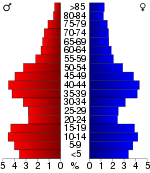
In the county the population was spread out with 28.60% under the age of 18, 8.30% from 18 to 24, 28.80% from 25 to 44, 21.70% from 45 to 64, and 12.60% who were 65 years of age or older. The median age was 36 years. For every 100 females there were 100.90 males. For every 100 females age 18 and over, there were 98.80 males.
The median income for a household
in the county was $45,474, and the median income for a family was $53,632. Males had a median income of $38,675 versus $26,109 for females. The per capita income
for the county was $20,150. About 5.40% of families and 7.30% of the population were below the poverty line, including 9.00% of those under age 18 and 6.40% of those age 65 or over.
. The cities of Augusta
and El Dorado
are considered governmentally independent and are excluded from the census figures for the townships. In the following table, the population center is the largest city (or cities) included in that township's population total, if it is of a significant size.
District Office In Neighboring County
Kansas
Historical
Maps
Kansas
Kansas is a US state located in the Midwestern United States. It is named after the Kansas River which flows through it, which in turn was named after the Kansa Native American tribe, which inhabited the area. The tribe's name is often said to mean "people of the wind" or "people of the south...
, in the Central
Central United States
The Central United States is sometimes conceived as between the Eastern United States and Western United States as part of a three-region model, roughly coincident with the Midwestern United States plus the western and central portions of the Southern United States; the term is also sometimes used...
United States
United States
The United States of America is a federal constitutional republic comprising fifty states and a federal district...
. As of the 2010 census, the county population was 65,880. Its county seat
County seat
A county seat is an administrative center, or seat of government, for a county or civil parish. The term is primarily used in the United States....
and most populous city is El Dorado
El Dorado, Kansas
El Dorado is a city situated along the Walnut River in the central part of Butler County, located in south-central Kansas, in the Central United States. As of the 2010 census, the city population was 13,021. It is the county seat and most populous city of Butler County...
. The county is a part of the Wichita
Wichita, Kansas
Wichita is the largest city in the U.S. state of Kansas.As of the 2010 census, the city population was 382,368. Located in south-central Kansas on the Arkansas River, Wichita is the county seat of Sedgwick County and the principal city of the Wichita metropolitan area...
Metropolitan Statistical Area
Wichita metropolitan area
The Wichita Metropolitan Statistical Area, as defined by the United States Census Bureau, is an area consisting of four counties in south central Kansas, anchored by the city of Wichita. As of the 2010 census, the MSA had a population of 659,372...
.
19th century
It was named in honor of a U.S. Senator from South Carolina, Andrew Butler (1796–1857), who was one of the authors of the Kansas-Nebraska Act of 1854 and a strong advocate of Kansas becoming a slave stateSlave state
In the United States of America prior to the American Civil War, a slave state was a U.S. state in which slavery was legal, whereas a free state was one in which slavery was either prohibited from its entry into the Union or eliminated over time...
.
In 1877, the Florence, El Dorado, and Walnut Valley Railroad Company built a branch line from Florence
Florence, Kansas
Florence is a city in Marion County, Kansas, United States. The city was named after the daughter of former Kansas Governor Samuel J. Crawford. As of the 2010 census, the city population was 465.-19th century:...
to El Dorado
El Dorado, Kansas
El Dorado is a city situated along the Walnut River in the central part of Butler County, located in south-central Kansas, in the Central United States. As of the 2010 census, the city population was 13,021. It is the county seat and most populous city of Butler County...
, in 1881 it was extended to Douglass
Douglass, Kansas
Douglass is a city in Butler County, Kansas, United States. As of the 2010 census, the city population was 1,700.-19th century:In 1877, the Florence, El Dorado, and Walnut Valley Railroad Company built a branch line from Florence to El Dorado, in 1881 it was extended to Douglass, and later to...
, and later to Arkansas City
Arkansas City, Kansas
Arkansas City is a city situated at the confluence of the Arkansas and Walnut rivers in the southwestern part of Cowley County, located in south-central Kansas, in the central United States. As of the 2010 census, the city population was 12,415....
. The line was leased and operated by the Atchison, Topeka and Santa Fe Railway
Atchison, Topeka and Santa Fe Railway
The Atchison, Topeka and Santa Fe Railway , often abbreviated as Santa Fe, was one of the larger railroads in the United States. The company was first chartered in February 1859...
. The line from Florence
Florence, Kansas
Florence is a city in Marion County, Kansas, United States. The city was named after the daughter of former Kansas Governor Samuel J. Crawford. As of the 2010 census, the city population was 465.-19th century:...
to El Dorado
El Dorado, Kansas
El Dorado is a city situated along the Walnut River in the central part of Butler County, located in south-central Kansas, in the Central United States. As of the 2010 census, the city population was 13,021. It is the county seat and most populous city of Butler County...
was abandoned in 1942. The original branch line connected Florence
Florence, Kansas
Florence is a city in Marion County, Kansas, United States. The city was named after the daughter of former Kansas Governor Samuel J. Crawford. As of the 2010 census, the city population was 465.-19th century:...
, Burns
Burns, Kansas
Burns is a city in Marion County, Kansas, United States. The city name came from a nearby train station, which was named prior to the city being incorporated. As of the 2010 census, the city population was 228.-History:-19th century:...
, De Graff, El Dorado
El Dorado, Kansas
El Dorado is a city situated along the Walnut River in the central part of Butler County, located in south-central Kansas, in the Central United States. As of the 2010 census, the city population was 13,021. It is the county seat and most populous city of Butler County...
, Augusta
Augusta, Kansas
Augusta is a city in Butler County, Kansas, United States. As of the 2010 census, the city population was 9,274.-19th century:The confluence of the Whitewater River and the Walnut River was originally inhabited by Native Americans , who found the land ideal for hunting and fishing. In 1868 C. N...
, Douglass
Douglass, Kansas
Douglass is a city in Butler County, Kansas, United States. As of the 2010 census, the city population was 1,700.-19th century:In 1877, the Florence, El Dorado, and Walnut Valley Railroad Company built a branch line from Florence to El Dorado, in 1881 it was extended to Douglass, and later to...
, Rock
Rock, Kansas
Rock is an unincorporated community in Cowley County, Kansas, United States.-19th century:The post office was established August 12, 1870. The nearby Bucher Bridge is on the National Register of Historic Places....
, Akron, Winfield
Winfield, Kansas
Winfield is a city situated along the Walnut River in the west-central part of Cowley County, located in South Central Kansas, in the Central United States. As of the 2010 census, the city population was 12,301...
, Arkansas City
Arkansas City, Kansas
Arkansas City is a city situated at the confluence of the Arkansas and Walnut rivers in the southwestern part of Cowley County, located in south-central Kansas, in the central United States. As of the 2010 census, the city population was 12,415....
.
In 1887, the Chicago, Kansas and Nebraska Railway built a branch line north-south from Herington
Herington, Kansas
Herington is a city in Dickinson and Morris counties in the U.S. state of Kansas. Named after its founder, Monroe Davis Herington. As of the 2010 census, the city population was 2,526.-19th century:...
to Caldwell
Caldwell, Kansas
Caldwell is a city in Sumner County, Kansas, United States. As of the 2010 census, the city population was 1,068.-19th century:In 1887, the Chicago, Kansas and Nebraska Railway built a branch line north-south from Herington to Caldwell...
. This branch line connected Herington
Herington, Kansas
Herington is a city in Dickinson and Morris counties in the U.S. state of Kansas. Named after its founder, Monroe Davis Herington. As of the 2010 census, the city population was 2,526.-19th century:...
, Lost Springs
Lost Springs, Kansas
Lost Springs is a city in Marion County, Kansas, United States. It was named for the old lost spring near the city. As of the 2010 census, the city population was 70.-19th century:...
, Lincolnville
Lincolnville, Kansas
Lincolnville is a city in Marion County, Kansas, United States. As of the 2010 census, the city population was 203.-19th century:For millennia, the land that is currently Kansas was inhabited by Native Americans. In 1803, most of modern Kansas was secured by the United States as part of the...
, Antelope
Antelope, Kansas
Antelope is an unincorporated community in Marion County, Kansas, United States. Antelope got its name from Antelope grazing near where the first school was being built.-19th century:...
, Marion
Marion, Kansas
Marion is a city in and the county seat of Marion County, Kansas, United States. It was named in honor of Francis Marion, a Brigadier General of the American Revolutionary War, known as the "Swamp Fox". As of the 2010 census, the city population was 1,927....
, Aulne
Aulne, Kansas
Aulne is an unincorporated community in Marion County, Kansas, United States. The Aulne name was suggested by officials of the railroad when it was built through Aulne.-19th century:...
, Peabody
Peabody, Kansas
Peabody is a city in Marion County, Kansas, United States. It is named after F.H. Peabody, of Boston, former vice-president of the Atchison, Topeka and Santa Fe Railway. Peabody is well known in the region for its Independence Day Celebration on July 4, and its historic 1880's downtown main street...
, Elbing
Elbing, Kansas
Elbing is a city in Butler County, Kansas, United States. It is named after the city Elbląg in northern Poland, formerly Prussia. As of the 2010 census, the city population was 229.-History:...
, Whitewater
Whitewater, Kansas
Whitewater is a city in Butler County, Kansas, United States. As of the 2010 census, the city population was 718.-19th century:In 1887, the Chicago, Kansas and Nebraska Railway built a branch line north-south from Herington through Whitewater to Caldwell...
, Furley
Furley, Kansas
Furley is an unincorporated community in Sedgwick County, Kansas, United States.-19th century:In 1887, the Chicago, Kansas and Nebraska Railway built a branch line north-south from Herington through Furley to Caldwell. By 1893, this branch line was incrementally built to Fort Worth, Texas...
, Kechi
Kechi, Kansas
Kechi is a city in Sedgwick County, Kansas, United States. As of the 2010 census, the city population was 1,909.-19th century:In 1887, the Chicago, Kansas and Nebraska Railway built a branch line north-south from Herington through Kechi to Caldwell...
, Wichita
Wichita, Kansas
Wichita is the largest city in the U.S. state of Kansas.As of the 2010 census, the city population was 382,368. Located in south-central Kansas on the Arkansas River, Wichita is the county seat of Sedgwick County and the principal city of the Wichita metropolitan area...
, Peck
Peck, Kansas
Peck is an unincorporated community on the Sedgwick County and Sumner County border in Kansas, United States.-19th century:In 1887, the Chicago, Kansas and Nebraska Railway built a branch line north-south from Herington through Peck to Caldwell...
, Corbin
Corbin, Kansas
Corbin is a community in Sumner County, Kansas, United States. The post office was established February 6, 1884, and discontinued February 16, 1975. The nearby Spring Creek School is on the National Register of Historic Places.-19th century:...
, Wellington
Wellington, Kansas
Wellington is a city in and the county seat of Sumner County, Kansas, United States. As of the 2010 census, the city population was 8,172.-19th century:...
, Caldwell
Caldwell, Kansas
Caldwell is a city in Sumner County, Kansas, United States. As of the 2010 census, the city population was 1,068.-19th century:In 1887, the Chicago, Kansas and Nebraska Railway built a branch line north-south from Herington to Caldwell...
. By 1893, this branch line was incrementally built to Fort Worth, Texas
Fort Worth, Texas
Fort Worth is the 16th-largest city in the United States of America and the fifth-largest city in the state of Texas. Located in North Central Texas, just southeast of the Texas Panhandle, the city is a cultural gateway into the American West and covers nearly in Tarrant, Parker, Denton, and...
. This line is called the "OKT". The Chicago, Kansas and Nebraska Railway was foreclosed in 1891 and was taken over by Chicago, Rock Island and Pacific Railway, which shut down in 1980 and reorganized as Oklahoma, Kansas and Texas Railroad
Oklahoma, Kansas and Texas Railroad
-OKT I:The Oklahoma, Kansas and Texas Railroad , was originally created on May 29, 1980 after the demise of the Chicago, Rock Island and Pacific Railroad on March 31, 1980...
, merged in 1988 with Missouri Pacific Railroad
Missouri Pacific Railroad
The Missouri Pacific Railroad , also known as the MoPac, was one of the first railroads in the United States west of the Mississippi River. MoPac was a Class I railroad growing from dozens of predecessors and mergers, including the St. Louis, Iron Mountain and Southern Railway , Texas and Pacific...
, and finally merged in 1997 with Union Pacific Railroad
Union Pacific Railroad
The Union Pacific Railroad , headquartered in Omaha, Nebraska, is the largest railroad network in the United States. James R. Young is president, CEO and Chairman....
. Most locals still refer to this railroad as the "Rock Island".
21st century
In 2010, the Keystone-Cushing PipelineKeystone Pipeline
The Keystone Pipeline System is a pipeline system to transport synthetic crude oil and diluted bitumen from the Athabasca Oil Sands in northeastern Alberta, Canada to multiple destinations in the United States, which include refineries in Illinois, Cushing oil distribution hub in Oklahoma, and...
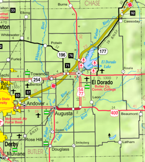
(Phase II) was constructed north to south through Butler County (near Potwin
Potwin, Kansas
Potwin is a city in Butler County, Kansas, United States. It is named after the town site land owner Charles Potwin. As of the 2010 census, the city population was 449.-19th century:Potwin was incorporated as a town on April 8, 1885...
, Towanda
Towanda, Kansas
Towanda is a city in Butler County, Kansas, United States. As of the 2010 census, the city population was 1,450.-21st century:In 2010, the Keystone-Cushing Pipeline was constructed a few blocks west of Towanda , running north to south through Butler County, with much controversy over tax...
, Augusta
Augusta, Kansas
Augusta is a city in Butler County, Kansas, United States. As of the 2010 census, the city population was 9,274.-19th century:The confluence of the Whitewater River and the Walnut River was originally inhabited by Native Americans , who found the land ideal for hunting and fishing. In 1868 C. N...
, Douglass
Douglass, Kansas
Douglass is a city in Butler County, Kansas, United States. As of the 2010 census, the city population was 1,700.-19th century:In 1877, the Florence, El Dorado, and Walnut Valley Railroad Company built a branch line from Florence to El Dorado, in 1881 it was extended to Douglass, and later to...
), with much controversy over tax exemption and environmental concerns (if a leak ever occurs). A pumping station named Burns was built 2 miles north of Potwin
Potwin, Kansas
Potwin is a city in Butler County, Kansas, United States. It is named after the town site land owner Charles Potwin. As of the 2010 census, the city population was 449.-19th century:Potwin was incorporated as a town on April 8, 1885...
, and new power lines were built from a high-voltage line 0.3 mile east of De Graff.
Law and government
Butler County was a prohibition, or "dry"Dry county
A dry county is a county in the United States whose government forbids the sale of alcoholic beverages. Some prohibit off-premises sale, some prohibit on-premises sale, and some prohibit both. Hundreds of dry counties exist across the United States, almost all of them in the South...
, county until the Kansas Constitution was amended in 1986 and voters approved the sale of alcoholic liquor by the individual drink with a 30% food sales requirement.
Presidential elections
Like of most of Kansas's counties, Butler county is solidly Republican. In 2008 John McCainJohn McCain
John Sidney McCain III is the senior United States Senator from Arizona. He was the Republican nominee for president in the 2008 United States election....
carried the county by a nearly two-to-one margin over Barack Obama
Barack Obama
Barack Hussein Obama II is the 44th and current President of the United States. He is the first African American to hold the office. Obama previously served as a United States Senator from Illinois, from January 2005 until he resigned following his victory in the 2008 presidential election.Born in...
. Since at least 1992 no Democratic candidate has received more than 40% of the county's vote. The last Democratic candidate to carry the county was Jimmy Carter
Jimmy Carter
James Earl "Jimmy" Carter, Jr. is an American politician who served as the 39th President of the United States and was the recipient of the 2002 Nobel Peace Prize, the only U.S. President to have received the Prize after leaving office...
in 1976.
Geography
According to the 2000 census, the county has a total area of 1446.42 square miles (3,746.2 km²), the largest county in Kansas, of which 1427.85 square miles (3,698.1 km²) (or 98.72%) is land and 18.57 square miles (48.1 km²) (or 1.28%) is water.Adjacent counties
- Chase CountyChase County, KansasChase County is a county located in Central Kansas, in the Central United States. As of the 2010 census, the county population was 2,790. Its county seat and most populous city is Cottonwood Falls. Chase County is part of the Emporia Micropolitan Statistical Area.The county has been the subject...
(northeast) - Greenwood CountyGreenwood County, KansasGreenwood County is a county located in Southeast Kansas, in the Central United States. As of the 2010 census, the county population was 6,689...
(east) - Elk CountyElk County, KansasElk County is a county located in Southeast Kansas, in the Central United States. As of the 2010 census, the county population was 2,882...
(southeast) - Cowley CountyCowley County, KansasCowley County is a county located in south-central Kansas, in the Central United States. As of the 2010 census, the county population was 36,311. Its county seat and most populous city is Winfield...
(south) - Sumner CountySumner County, KansasSumner County is a county located in the U.S. state of Kansas. The county's population was 24,132 for the 2010 census. Its county seat is Wellington. Sumner County is part of the Wichita, Kansas Metropolitan Statistical Area. It was named in honor of Charles Sumner, a U.S...
(southwest) - Harvey CountyHarvey County, KansasHarvey County is a county located in South Central Kansas, in the Central United States. As of the 2010 census, the county population was 34,684. Its county seat and most populous city is Newton. The county is a part of the Wichita Metropolitan Statistical Area which also includes Butler,...
(west) - Sedgwick CountySedgwick County, KansasSedgwick County is a county located in the U.S. state of Kansas. The county's population was 498,365 for the 2010 census. The largest city and county seat is Wichita. The county was named after General John Sedgwick...
(west) - Marion CountyMarion County, KansasMarion County is a county located in the U.S. state of Kansas. As of the 2010 census, the county population was 12,660. The county seat is Marion...
(northwest)
Major highways
Sources: National Atlas, U.S. Census Bureau- Interstate 35Interstate 35Interstate 35 is a north–south Interstate Highway in the central United States. I-35 stretches from Laredo, Texas, on the U.S.-Mexico border to Duluth, Minnesota, at Minnesota Highway 61 and 26th Avenue East. Many interstates used to have splits or spurs indicated with suffixed letters , but I-35...
- U.S. Route 54U.S. Route 54U.S. Route 54 is an east–west United States highway that runs northeast-southwest for 1,197 miles from western Illinois to El Paso, Texas. It enters and leaves Texas twice...
- U.S. Route 77U.S. Route 77U.S. Route 77 is a north–south United States highway. It is unsigned in and around Dallas, Texas. Its historic segment through South Dakota and Minnesota was decommissioned with the advent of Interstate 29 but otherwise the route has been spared the decommissioning that has shortened other US...
- Kansas Highway 96K-96 (Kansas highway)K-96 is a state highway in central and southern Kansas. Its western terminus is at the Colorado state line east of Towner, Colorado, where it continues as Colorado State Highway 96; its eastern terminus since 1999 is at U.S. Route 54/U.S. Route 400 east of Wichita.The eastern terminus was once at...
- Kansas Highway 177K-177 (Kansas highway)K-177 is a state highway in central Kansas. It runs from US-54 near El Dorado to Manhattan, passing through the Flint Hills. It is part of the Flint Hills Scenic Byway and the Prairie Parkway.-Route description:...
- Kansas Highway 196K-196 (Kansas highway)K-196 is a highway that runs from I-135 just south of Newton, east to K-254, just east of El Dorado, Kansas. The highway runs along the south border the town of Whitewater and bypasses Potwin to the south. The highway runs through Harvey County and Butler County.-Route description:K-196 begins at...
- Kansas Highway 254K-254 (Kansas highway)K-254 links Wichita to El Dorado. The road begins at the intersection of I-135/US-81/K-15 and I-235 north of Wichita. It bypasses Kechi, Benton and Towanda, ending in downtown El Dorado at an intersection with US-54 and US-77. It is limited access from I-135 to just east of Kechi...
Demographics
As of the U.S. Census in 2000
United States Census, 2000
The Twenty-second United States Census, known as Census 2000 and conducted by the Census Bureau, determined the resident population of the United States on April 1, 2000, to be 281,421,906, an increase of 13.2% over the 248,709,873 persons enumerated during the 1990 Census...
, there were 59,482 people, 21,527 households, and 16,059 families residing in the county. The population density
Population density
Population density is a measurement of population per unit area or unit volume. It is frequently applied to living organisms, and particularly to humans...
was 42 people per square mile (16/km²). There were 23,176 housing units at an average density of 16 per square mile (6/km²). The racial makeup
Race (United States Census)
Race and ethnicity in the United States Census, as defined by the Federal Office of Management and Budget and the United States Census Bureau, are self-identification data items in which residents choose the race or races with which they most closely identify, and indicate whether or not they are...
of the county was 94.94% White
White American
White Americans are people of the United States who are considered or consider themselves White. The United States Census Bureau defines White people as those "having origins in any of the original peoples of Europe, the Middle East, or North Africa...
, 1.38% Black or African American
African American
African Americans are citizens or residents of the United States who have at least partial ancestry from any of the native populations of Sub-Saharan Africa and are the direct descendants of enslaved Africans within the boundaries of the present United States...
, 0.91% Native American
Native Americans in the United States
Native Americans in the United States are the indigenous peoples in North America within the boundaries of the present-day continental United States, parts of Alaska, and the island state of Hawaii. They are composed of numerous, distinct tribes, states, and ethnic groups, many of which survive as...
, 0.40% Asian
Asian American
Asian Americans are Americans of Asian descent. The U.S. Census Bureau definition of Asians as "Asian” refers to a person having origins in any of the original peoples of the Far East, Southeast Asia, or the Indian subcontinent, including, for example, Cambodia, China, India, Indonesia, Japan,...
, 0.03% Pacific Islander
Pacific Islander American
Pacific Islander Americans, also known as Oceanian Americans, are residents of the United States with original ancestry from Oceania. They represent the smallest racial group counted in the United States census of 2000. They numbered 874,000 people or 0.3 percent of the United States population...
, 0.66% from other races, and 1.69% two or more races
Multiracial
The terms multiracial and mixed-race describe people whose ancestries come from multiple races. Unlike the term biracial, which often is only used to refer to having parents or grandparents of two different races, the term multiracial may encompass biracial people but can also include people with...
. Hispanic
Hispanic
Hispanic is a term that originally denoted a relationship to Hispania, which is to say the Iberian Peninsula: Andorra, Gibraltar, Portugal and Spain. During the Modern Era, Hispanic sometimes takes on a more limited meaning, particularly in the United States, where the term means a person of ...
or Latino
Latino
The demonyms Latino and Latina , are defined in English language dictionaries as:* "a person of Latin-American descent."* "A Latin American."* "A person of Hispanic, especially Latin-American, descent, often one living in the United States."...
of any race were 2.25% of the population.
There were 21,527 household
Household
The household is "the basic residential unit in which economic production, consumption, inheritance, child rearing, and shelter are organized and carried out"; [the household] "may or may not be synonymous with family"....
s out of which 37.90% had children under the age of 18 living with them, 62.60% were married couples
Marriage
Marriage is a social union or legal contract between people that creates kinship. It is an institution in which interpersonal relationships, usually intimate and sexual, are acknowledged in a variety of ways, depending on the culture or subculture in which it is found...
living together, 8.30% had a female householder with no husband present, and 25.40% were non-families. 21.90% of all households were made up of individuals and 9.40% had someone living alone who was 65 years of age or older. The average household size was 2.67 and the average family size was 3.13.
In the county the population was spread out with 28.60% under the age of 18, 8.30% from 18 to 24, 28.80% from 25 to 44, 21.70% from 45 to 64, and 12.60% who were 65 years of age or older. The median age was 36 years. For every 100 females there were 100.90 males. For every 100 females age 18 and over, there were 98.80 males.
The median income for a household
Median household income
The median household income is commonly used to generate data about geographic areas and divides households into two equal segments with the first half of households earning less than the median household income and the other half earning more...
in the county was $45,474, and the median income for a family was $53,632. Males had a median income of $38,675 versus $26,109 for females. The per capita income
Per capita income
Per capita income or income per person is a measure of mean income within an economic aggregate, such as a country or city. It is calculated by taking a measure of all sources of income in the aggregate and dividing it by the total population...
for the county was $20,150. About 5.40% of families and 7.30% of the population were below the poverty line, including 9.00% of those under age 18 and 6.40% of those age 65 or over.
Incorporated cities
Name and population (2005 estimate):- El DoradoEl Dorado, KansasEl Dorado is a city situated along the Walnut River in the central part of Butler County, located in south-central Kansas, in the Central United States. As of the 2010 census, the city population was 13,021. It is the county seat and most populous city of Butler County...
, 12,659 (county seat) - AndoverAndover, KansasAndover is a city in Butler and Sedgwick counties in the U.S. state of Kansas. As of the 2010 census, the city population was 11,791. Located almost entirely in Butler County, it is part of the Wichita Metropolitan Statistical Area...
, 9,114 - AugustaAugusta, KansasAugusta is a city in Butler County, Kansas, United States. As of the 2010 census, the city population was 9,274.-19th century:The confluence of the Whitewater River and the Walnut River was originally inhabited by Native Americans , who found the land ideal for hunting and fishing. In 1868 C. N...
, 8,608 - Rose HillRose Hill, KansasRose Hill is a city in Butler County, Kansas, United States. As of the 2010 census, the city population was 3,931.-Geography:Rose Hill is located at...
, 3,896 - DouglassDouglass, KansasDouglass is a city in Butler County, Kansas, United States. As of the 2010 census, the city population was 1,700.-19th century:In 1877, the Florence, El Dorado, and Walnut Valley Railroad Company built a branch line from Florence to El Dorado, in 1881 it was extended to Douglass, and later to...
, 1,799 - TowandaTowanda, KansasTowanda is a city in Butler County, Kansas, United States. As of the 2010 census, the city population was 1,450.-21st century:In 2010, the Keystone-Cushing Pipeline was constructed a few blocks west of Towanda , running north to south through Butler County, with much controversy over tax...
, 1,355 - BentonBenton, KansasBenton is a city in Butler County, Kansas, United States. As of the 2010 census, the city population was 880.-Geography:Benton is located at . According to the United States Census Bureau, the city has a total area of , all of it land.-Demographics:As of the census of 2000, there were 827 people,...
, 817 - LeonLeon, KansasLeon is a city in Butler County, Kansas, United States. As of the 2010 census, the city population was 704.-Geography:Leon is located at . According to the United States Census Bureau, the city has a total area of , all of it land....
, 648 - WhitewaterWhitewater, KansasWhitewater is a city in Butler County, Kansas, United States. As of the 2010 census, the city population was 718.-19th century:In 1887, the Chicago, Kansas and Nebraska Railway built a branch line north-south from Herington through Whitewater to Caldwell...
, 639 - PotwinPotwin, KansasPotwin is a city in Butler County, Kansas, United States. It is named after the town site land owner Charles Potwin. As of the 2010 census, the city population was 449.-19th century:Potwin was incorporated as a town on April 8, 1885...
, 438 - ElbingElbing, KansasElbing is a city in Butler County, Kansas, United States. It is named after the city Elbląg in northern Poland, formerly Prussia. As of the 2010 census, the city population was 229.-History:...
, 208 - LathamLatham, KansasLatham is a city in Butler County, Kansas, United States. As of the 2010 census, the city population was 139.-Geography:Latham is located at . According to the United States Census Bureau, the city has a total area of , all of it land.-Demographics:As of the census of 2000, there were 164 people,...
, 164 - CassodayCassoday, KansasCassoday is a city in Butler County, Kansas, United States. It is known as the "Prairie Chicken Capital of the World." As of the 2010 census, the city population was 129.-Geography:Cassoday is located at , in the scenic Flint Hills...
, 128
Unincorporated places
- BeaumontBeaumont, KansasBeaumont is an unincorporated community in Butler County, Kansas, United States. The post office was established June 3, 1880, and was discontinued August 16, 1997. The Beaumont St. Louis and San Francisco Railroad Water Tank in Beaumont is on the National Register of Historic Places.Beaumont...
- Bois d'ArcBois d'Arc, KansasBois d'Arc is an unincorporated community in Butler County, Kansas, United States. The post office was established December 21, 1892, and was discontinued March 31, 1904...
- BrainerdBrainerd, KansasBrainerd is an unincorporated community in Butler County, Kansas, United States.-20th century:In 1961, Frederic Remington High School was built immediately north of Brainerd. Leading up to this new school, Whitewater, Potwin, Brainerd, Elbing, Furley, Countryside, and Golden Gate schools merged to...
- Chelsea
- DeGraff
- Gordon
- Haverhill
- Hopkins
- Keighley
- Lorena
- Pontiac
- Prospect
- Providence
- RosaliaRosalia, KansasRosalia is an unincorporated community in Butler County, Kansas, United States. Rosalia is east of El Dorado. Rosalia has a post office with ZIP code 67132.-Further reading:County...
- Salter
- Smileyberg
- Vanora
Ghost towns and defunct settlements
Butler County contained a number of oil boom towns that have since been abandoned. Many were company owned towns.- Aikman
- Alki
- Amador
- Browntown
- Durachen
- Frazier
- Magna City
- Midian
- Oil Hill
- Oil Valley
- Ophir
- Ramsey
- Wingate
Townships
Butler County is divided into twenty-nine townshipsCivil township
A civil township is a widely used unit of local government in the United States, subordinate to, and geographic divisions of, a county. Specific responsibilities and the degree of autonomy vary based on each state. Civil townships are distinct from survey townships, but in states that have both,...
. The cities of Augusta
Augusta, Kansas
Augusta is a city in Butler County, Kansas, United States. As of the 2010 census, the city population was 9,274.-19th century:The confluence of the Whitewater River and the Walnut River was originally inhabited by Native Americans , who found the land ideal for hunting and fishing. In 1868 C. N...
and El Dorado
El Dorado, Kansas
El Dorado is a city situated along the Walnut River in the central part of Butler County, located in south-central Kansas, in the Central United States. As of the 2010 census, the city population was 13,021. It is the county seat and most populous city of Butler County...
are considered governmentally independent and are excluded from the census figures for the townships. In the following table, the population center is the largest city (or cities) included in that township's population total, if it is of a significant size.
| Township | FIPS | Population center |
Population | Population density /km² (/sq mi) |
Land area km² (sq mi) | Water area km² (sq mi) | Water % | Geographic coordinates |
|---|---|---|---|---|---|---|---|---|
| Augusta | 03325 | 1,405 | 17 (43) | 84 (32) | 1 (0) | 0.68% | 37°41′32"N 96°59′15"W | |
| Benton | 06200 | Benton Benton, Kansas Benton is a city in Butler County, Kansas, United States. As of the 2010 census, the city population was 880.-Geography:Benton is located at . According to the United States Census Bureau, the city has a total area of , all of it land.-Demographics:As of the census of 2000, there were 827 people,... |
2,211 | 24 (61) | 93 (36) | 0 (0) | 0 % | 37°47′0"N 97°6′11"W |
| Bloomington | 07500 | 544 | 6 (15) | 93 (36) | 0 (0) | 0 % | 37°35′57"N 96°54′1"W | |
| Bruno | 08825 | Andover Andover, Kansas Andover is a city in Butler and Sedgwick counties in the U.S. state of Kansas. As of the 2010 census, the city population was 11,791. Located almost entirely in Butler County, it is part of the Wichita Metropolitan Statistical Area... |
9,744 | 107 (278) | 91 (35) | 0 (0) | 0.10% | 37°41′37"N 97°6′48"W |
| Chelsea | 12750 | 190 | 1 (2) | 261 (101) | 17 (7) | 6.15% | 37°55′27"N 96°44′34"W | |
| Clay | 13575 | 83 | 1 (2) | 94 (36) | 0 (0) | 0.22% | 37°31′21"N 96°45′39"W | |
| Clifford | 14175 | 259 | 2 (6) | 108 (42) | 0 (0) | 0.18% | 38°2′7"N 96°58′41"W | |
| Douglass | 18425 | Douglass Douglass, Kansas Douglass is a city in Butler County, Kansas, United States. As of the 2010 census, the city population was 1,700.-19th century:In 1877, the Florence, El Dorado, and Walnut Valley Railroad Company built a branch line from Florence to El Dorado, in 1881 it was extended to Douglass, and later to... |
2,306 | 25 (64) | 93 (36) | 0 (0) | 0.32% | 37°31′1"N 97°0′33"W |
| El Dorado | 20100 | 1,700 | 12 (32) | 140 (54) | 2 (1) | 1.46% | 37°48′38"N 96°52′23"W | |
| Fairmount | 22275 | Elbing Elbing, Kansas Elbing is a city in Butler County, Kansas, United States. It is named after the city Elbląg in northern Poland, formerly Prussia. As of the 2010 census, the city population was 229.-History:... |
511 | 5 (14) | 94 (36) | 0 (0) | 0.14% | 38°2′34"N 97°5′53"W |
| Fairview | 22450 | 491 | 5 (14) | 92 (36) | 0 (0) | 0.14% | 37°52′15"N 96°59′46"W | |
| Glencoe | 26400 | 239 | 1 (4) | 161 (62) | 1 (0) | 0.60% | 37°41′29"N 96°36′57"W | |
| Hickory | 31750 | 90 | 1 (1) | 162 (62) | 1 (0) | 0.67% | 37°37′5"N 96°37′45"W | |
| Lincoln | 40500 | 317 | 1 (3) | 257 (99) | 2 (1) | 0.64% | 37°57′6"N 96°53′1"W | |
| Little Walnut | 41625 | Leon Leon, Kansas Leon is a city in Butler County, Kansas, United States. As of the 2010 census, the city population was 704.-Geography:Leon is located at . According to the United States Census Bureau, the city has a total area of , all of it land.... |
1,002 | 11 (28) | 94 (36) | 0 (0) | 0.44% | 37°41′34"N 96°46′37"W |
| Logan | 41775 | 154 | 2 (4) | 94 (36) | 0 (0) | 0.16% | 37°37′15"N 96°45′13"W | |
| Milton | 46875 | Whitewater Whitewater, Kansas Whitewater is a city in Butler County, Kansas, United States. As of the 2010 census, the city population was 718.-19th century:In 1887, the Chicago, Kansas and Nebraska Railway built a branch line north-south from Herington through Whitewater to Caldwell... |
1,136 | 12 (31) | 94 (36) | 0 (0) | 0.15% | 37°57′21"N 97°7′14"W |
| Murdock | 49225 | 378 | 4 (10) | 93 (36) | 0 (0) | 0 % | 37°51′42"N 97°6′23"W | |
| Pleasant | 56200 | Rose Hill Rose Hill, Kansas Rose Hill is a city in Butler County, Kansas, United States. As of the 2010 census, the city population was 3,931.-Geography:Rose Hill is located at... (part) |
4,649 | 50 (129) | 93 (36) | 0 (0) | 0.11% | 37°35′49"N 97°6′54"W |
| Plum Grove | 56850 | Potwin Potwin, Kansas Potwin is a city in Butler County, Kansas, United States. It is named after the town site land owner Charles Potwin. As of the 2010 census, the city population was 449.-19th century:Potwin was incorporated as a town on April 8, 1885... |
661 | 7 (19) | 92 (36) | 1 (0) | 0.58% | 37°56′46"N 97°0′51"W |
| Prospect | 57775 | 2,033 | 10 (26) | 203 (78) | 16 (6) | 7.20% | 37°49′25"N 96°45′35"W | |
| Richland | 59250 | Rose Hill (part) | 2,399 | 26 (66) | 94 (36) | 0 (0) | 0.02% | 37°31′37"N 97°6′29"W |
| Rock Creek | 60475 | 299 | 3 (8) | 94 (36) | 0 (0) | 0 % | 37°31′19"N 96°53′3"W | |
| Rosalia | 61125 | 589 | 4 (9) | 162 (63) | 1 (0) | 0.58% | 37°46′47"N 96°37′22"W | |
| Spring | 67275 | 1,566 | 17 (43) | 94 (36) | 0 (0) | 0.13% | 37°41′36"N 96°52′52"W | |
| Sycamore | 69700 | Cassoday Cassoday, Kansas Cassoday is a city in Butler County, Kansas, United States. It is known as the "Prairie Chicken Capital of the World." As of the 2010 census, the city population was 129.-Geography:Cassoday is located at , in the scenic Flint Hills... |
333 | 1 (3) | 295 (114) | 2 (1) | 0.76% | 38°1′15"N 96°40′19"W |
| Towanda | 71150 | Towanda Towanda, Kansas Towanda is a city in Butler County, Kansas, United States. As of the 2010 census, the city population was 1,450.-21st century:In 2010, the Keystone-Cushing Pipeline was constructed a few blocks west of Towanda , running north to south through Butler County, with much controversy over tax... |
2,727 | 29 (76) | 93 (36) | 0 (0) | 0.14% | 37°47′32"N 96°59′43"W |
| Union | 72050 | Latham Latham, Kansas Latham is a city in Butler County, Kansas, United States. As of the 2010 census, the city population was 139.-Geography:Latham is located at . According to the United States Census Bureau, the city has a total area of , all of it land.-Demographics:As of the census of 2000, there were 164 people,... |
226 | 1 (4) | 161 (62) | 1 (0) | 0.72% | 37°32′2"N 96°38′41"W |
| Walnut | 74900 | 760 | 8 (21) | 92 (36) | 1 (0) | 0.77% | 37°36′4"N 96°59′31"W | |
| Sources: | ||||||||
Unified school districts
- USD 205, Bluestem
- LeonLeon, KansasLeon is a city in Butler County, Kansas, United States. As of the 2010 census, the city population was 704.-Geography:Leon is located at . According to the United States Census Bureau, the city has a total area of , all of it land....
, LathamLatham, KansasLatham is a city in Butler County, Kansas, United States. As of the 2010 census, the city population was 139.-Geography:Latham is located at . According to the United States Census Bureau, the city has a total area of , all of it land.-Demographics:As of the census of 2000, there were 164 people,...
, Rural Areas
- Leon
- USD 206, Remington-Whitewater
- WhitewaterWhitewater, KansasWhitewater is a city in Butler County, Kansas, United States. As of the 2010 census, the city population was 718.-19th century:In 1887, the Chicago, Kansas and Nebraska Railway built a branch line north-south from Herington through Whitewater to Caldwell...
, PotwinPotwin, KansasPotwin is a city in Butler County, Kansas, United States. It is named after the town site land owner Charles Potwin. As of the 2010 census, the city population was 449.-19th century:Potwin was incorporated as a town on April 8, 1885...
, ElbingElbing, KansasElbing is a city in Butler County, Kansas, United States. It is named after the city Elbląg in northern Poland, formerly Prussia. As of the 2010 census, the city population was 229.-History:...
, Rural Areas - Frederic Remington High SchoolFrederic Remington High SchoolFrederic Remington High School is a rural public secondary school, located between Whitewater and Potwin, and north of the unincorporated community of Brainerd. It is one of three schools operated by Unified School District 206, and is the sole high school in the district...
- Whitewater
- USD 375, Circle
- TowandaTowanda, KansasTowanda is a city in Butler County, Kansas, United States. As of the 2010 census, the city population was 1,450.-21st century:In 2010, the Keystone-Cushing Pipeline was constructed a few blocks west of Towanda , running north to south through Butler County, with much controversy over tax...
, BentonBenton, KansasBenton is a city in Butler County, Kansas, United States. As of the 2010 census, the city population was 880.-Geography:Benton is located at . According to the United States Census Bureau, the city has a total area of , all of it land.-Demographics:As of the census of 2000, there were 827 people,...
, Rural Areas
- Towanda
- USD 385, Andover
- AndoverAndover, KansasAndover is a city in Butler and Sedgwick counties in the U.S. state of Kansas. As of the 2010 census, the city population was 11,791. Located almost entirely in Butler County, it is part of the Wichita Metropolitan Statistical Area...
, Rural Areas
- Andover
- USD 394, Rose Hill
- Rose HillRose Hill, KansasRose Hill is a city in Butler County, Kansas, United States. As of the 2010 census, the city population was 3,931.-Geography:Rose Hill is located at...
, Rural Areas
- Rose Hill
- USD 396, Douglass
- DouglassDouglass, KansasDouglass is a city in Butler County, Kansas, United States. As of the 2010 census, the city population was 1,700.-19th century:In 1877, the Florence, El Dorado, and Walnut Valley Railroad Company built a branch line from Florence to El Dorado, in 1881 it was extended to Douglass, and later to...
, Rural Areas
- Douglass
- USD 402, Augusta
- AugustaAugusta, KansasAugusta is a city in Butler County, Kansas, United States. As of the 2010 census, the city population was 9,274.-19th century:The confluence of the Whitewater River and the Walnut River was originally inhabited by Native Americans , who found the land ideal for hunting and fishing. In 1868 C. N...
, Rural Areas
- Augusta
- USD 490, El Dorado
- El DoradoEl Dorado, KansasEl Dorado is a city situated along the Walnut River in the central part of Butler County, located in south-central Kansas, in the Central United States. As of the 2010 census, the city population was 13,021. It is the county seat and most populous city of Butler County...
, Rural Areas
- El Dorado
- USD 492, Flinthills
- RosaliaRosalia, KansasRosalia is an unincorporated community in Butler County, Kansas, United States. Rosalia is east of El Dorado. Rosalia has a post office with ZIP code 67132.-Further reading:County...
, CassodayCassoday, KansasCassoday is a city in Butler County, Kansas, United States. It is known as the "Prairie Chicken Capital of the World." As of the 2010 census, the city population was 129.-Geography:Cassoday is located at , in the scenic Flint Hills...
, Rural Areas
- Rosalia
District Office In Neighboring County
- USD 398, Peabody-Burns
- Rural Areas
College
- Butler County Community College, in El DoradoEl Dorado, KansasEl Dorado is a city situated along the Walnut River in the central part of Butler County, located in south-central Kansas, in the Central United States. As of the 2010 census, the city population was 13,021. It is the county seat and most populous city of Butler County...
See also
- National Register of Historic Places listings in Butler County, KansasNational Register of Historic Places listings in Butler County, KansasThis is a list of the National Register of Historic Places listings in Butler County, Kansas.This is intended to be a complete list of the properties on the National Register of Historic Places in Butler County, Kansas, United States...
Further reading
County- History of Butler County Kansas; Vol P Mooney; Standard Publishing; 869 pages; 1916. (Download 68MB PDF eBook)
Kansas
- History of the State of Kansas; William G. Cutler; A.T. Andreas Publisher; 1883. (Online HTML eBook)
- Kansas : A Cyclopedia of State History, Embracing Events, Institutions, Industries, Counties, Cities, Towns, Prominent Persons, Etc; 3 Volumes; Frank W. Blackmar; Standard Publishing Co; 944 / 955 / 824 pages; 1912. (Volume1 - Download 54MB PDF eBook), (Volume2 - Download 53MB PDF eBook), (Volume3 - Download 33MB PDF eBook)
External links
County- Butler County - Official Website
- Butler County - Directory of Public Officials
- Butler County - Information, Skyways
Historical
Maps
- Butler County Map, KDOT
- Kansas Highway Map, KDOT
- Kansas Railroad Map, KDOT
- Kansas School District Boundary Map, KSDE