

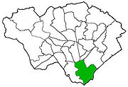
Butetown
Encyclopedia
Community (Wales)
A community is a division of land in Wales that forms the lowest-tier of local government in Wales. Welsh communities are analogous to civil parishes in England....
in the south
Cardiff South
Cardiff South or South Cardiff can refer to the collection of communities in the south of Cardiff, Wales. Although the usage is unofficial and boundaries are only ambiguously defined, they generally share the postcodes CF10, CF11 or CF24 and the telephone code 029...
of the city of Cardiff
Cardiff
Cardiff is the capital, largest city and most populous county of Wales and the 10th largest city in the United Kingdom. The city is Wales' chief commercial centre, the base for most national cultural and sporting institutions, the Welsh national media, and the seat of the National Assembly for...
, the capital of Wales
Wales
Wales is a country that is part of the United Kingdom and the island of Great Britain, bordered by England to its east and the Atlantic Ocean and Irish Sea to its west. It has a population of three million, and a total area of 20,779 km²...
. It was originally a model housing estate
Housing estate
A housing estate is a group of buildings built together as a single development. The exact form may vary from country to country. Accordingly, a housing estate is usually built by a single contractor, with only a few styles of house or building design, so they tend to be uniform in appearance...
built in the early nineteenth century by John Crichton-Stuart, 2nd Marquess of Bute
John Crichton-Stuart, 2nd Marquess of Bute
John Crichton-Stuart, 2nd Marquess of Bute, KT, FRS was the son of John, Lord Mount Stuart and the former Lady Elizabeth McDouall-Crichton...
, for whose title the area was named. Commonly known as "Tiger Bay
Tiger Bay
Tiger Bay was the local name for an area of Cardiff which covered Butetown and Cardiff Docks. It was re-branded as Cardiff Bay following the building of the Cardiff Barrage which dams the tidal rivers Ely and Taff to create a body of water.-History:...
", this area became one of the UK's first multicultural communities with people from over 50 countries settled here by the outbreak of World War I, working in the docks and allied industries. Some of the largest communities included the Somalis
Somali people
Somalis are an ethnic group located in the Horn of Africa, also known as the Somali Peninsula. The overwhelming majority of Somalis speak the Somali language, which is part of the Cushitic branch of the Afro-Asiatic language family...
, Yemenis
Yemeni British
Yemenis in the United Kingdom include citizens and non-citizen immigrants in the United Kingdom of Yemeni ancestry, as well as their descendants...
and Greeks
Greeks
The Greeks, also known as the Hellenes , are a nation and ethnic group native to Greece, Cyprus and neighboring regions. They also form a significant diaspora, with Greek communities established around the world....
, whose influence still lives on today. A Greek Orthodox church still stands at the top of Bute Street
Bute Street (Cardiff)
Bute Street is a street in Cardiff, Wales. It links Cardiff Bay and Butetown with Cardiff city centre. It now has no road number...
.
Development
In the 1960s, most of the original housing was demolished including the historic Loudoun Square, the original heart of Butetown. In its place was a typical 1960s housing estate of low-rise courts and alleys, and two high rise apartment blocks.In the 1980s, the new Atlantic Wharf
Red Dragon Centre
The Red Dragon Centre is an indoor entertainment complex in southern Cardiff, the capital of Wales.The complex features restaurants, cafés, an Old Orleans restaurant, a Hollywood Bowl with arcade amusements, an Odeon multiplex cinema, a Doctor Who visitor centre , a casino and an on-site car park...
development was built on the reclaimed West Bute Dock, and has involved the construction of some 1300 new houses. Together with the developments in the Inner Habour and Roath Basin, it was hoped this would spur redevelopment and employment in Butetown, but it seems not to have. The divide between the wealthy Cardiff Bay
Cardiff Bay
Cardiff Bay is the area created by the Cardiff Barrage in South Cardiff, the capital of Wales. The regeneration of Cardiff Bay is now widely regarded as one of the most successful regeneration projects in the United Kingdom. The Bay is supplied by two rivers to form a freshwater lake round the...
, and the poor Tiger Bay seems as wide as ever, although some of the surviving areas of historic Butetown are becoming prime office and retail locations. With the new Century Wharf development to the west on the banks of the Taff
River Taff
The River Taff is a large river in Wales. It rises as two rivers in the Brecon Beacons — the Taf Fechan and the Taf Fawr — before joining to form the Taff north of Merthyr Tydfil...
, the housing estate is becoming a little 'boxed in', increasing feelings of exclusion. Over the next few decades, the 1960s housing will require renewal and it is hoped that new development will be more suitable of the urban context of the area and will provide a better mix of private and public housing to help fully integrate the community with the rest of the city.
Although Butetown is a large area of Cardiff there is a small population compared to adjoining areas of Grangetown and Splott. The district can be split into four areas with James Street running through the middle, The area around Loundon Square is colloquial known as "The Bay" after Tiger Bay (though there are few buildings left from this era). This is in contrast to what the tourist call the Bay (actually in the Docks). The next area is Atlantic Wharf which is located in what was Newtown and the West Bute Dock, this is where Cardiff County Council are based. The next area is South of James Street or what the locals call "The Docks" This is a mixture of Private and State owned houses mixed around whats left of the actual port of Cardiff. Before the 1970s there were rows of terrace houses running from Stuart Street to Harrowby Street, But this is all gone now and in its place are Council houses, Techinquest, Mount Stuart School and a Car Park. There are some little gems left like Windsor Esplande that boast some of the oldest houses in the Docks and how could I forget old Rat Island. Nestled between the filled in Glamorganshire Canel and the east banks of the Taff, this is where the Royal Hammadryad Hospital was.
A three-year £13m project to redevelop a shopping parade, community hub, health centre and homes in Butetown began on 2010. The Loudoun Square development will include environmental aspects such as harvesting rain water. The project is a collaboration between Cardiff Community Housing Association (CCHA), Cardiff Council
Cardiff Council
The County Council of the City and County of Cardiff is the governing body for Cardiff, one of the Principal Areas of Wales. The council consists of 75 councillors, representing 29 electoral wards. The authority is properly styled as The County Council of the City and County of Cardiff or in...
and Cardiff and Vale University Health Board. The facilities and 62 new homes will follow four years of consultation with local residents.
Demographics
DemographicsDemographics
Demographics are the most recent statistical characteristics of a population. These types of data are used widely in sociology , public policy, and marketing. Commonly examined demographics include gender, race, age, disabilities, mobility, home ownership, employment status, and even location...
reveal that from the United Kingdom Census 2001
United Kingdom Census 2001
A nationwide census, known as Census 2001, was conducted in the United Kingdom on Sunday, 29 April 2001. This was the 20th UK Census and recorded a resident population of 58,789,194....
Census
- Overall Population: 4,487
- White British: 63.12%
- White Irish: 1.27%
- White Other: 3.25%
- Black or Mixed Black and White: 18.81%
- South Asian or Mixed Asian and White: 9.46%
- Chinese or Other (including mixed race): 4.10%
People identifying themselves as Welsh
Welsh people
The Welsh people are an ethnic group and nation associated with Wales and the Welsh language.John Davies argues that the origin of the "Welsh nation" can be traced to the late 4th and early 5th centuries, following the Roman departure from Britain, although Brythonic Celtic languages seem to have...
: 8.71%
Transport
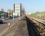
Cardiff Bay railway station
Cardiff Bay railway station , formerly Cardiff Bute Road, is a station serving the Cardiff Bay and Butetown areas of Cardiff. It is the southern terminus of the Butetown Branch Line 1 mile south of ....
with shuttle services every 7-8 minutes to Cardiff Queen Street.
Cardiff Bus
Cardiff Bus
Cardiff Bus is the dominant operator of bus services in Cardiff, Wales and the surrounding area, including Barry and Penarth. Its hub is Cardiff central bus station...
operates the 11 service to Pengam Green via Central Station
Cardiff Central bus station
Cardiff Central bus station is the main bus transport interchange in Cardiff, the capital city of Wales. With 34 stands, it is the largest bus station in the city and in Wales. It is located adjacent to Cardiff Central railway station forming a major bus-rail-cycle-taxi interchange.The station used...
, Splott
Splott
Splott is a district in the south of the city of Cardiff, capital of Wales, just east of the city centre. It was built up in the late 19th century on the land of two farms of the same name: Upper Splott and Lower Splott Farms. Splott is characterised by its once vast steelworks and rows of tightly...
and Tremorfa
Tremorfa
Tremorfa is a district of the city of Cardiff, Wales. It falls into the Splott ward of Cardiff.-Transport:Tremorfa is the terminus of the 12/13 routes operating to Culverhouse Cross via Splott, Central Stn, Canton and Ely...
and the 35 service to Gabalfa via Central Stn and Cathays
Cathays
Cathays is a district in the north of Cardiff, capital of Wales. It is an old suburb of Cardiff established in 1875. It is very densely populated and contains many older terraced houses giving it a Victorian era atmosphere...
. It also on the 1/2 Bay Circle route connecting the area with Grangetown
Grangetown, Cardiff
Grangetown is a community in the south of Cardiff, capital of Wales. It is one of the largest districts in the south of the city and is bordered by Riverside, Canton and Butetown. The River Taff winds its way through the area...
, Canton
Canton, Cardiff
Canton is an inner-city district and community in the west of Cardiff, capital of Wales, lying west of the city's civic centre. One of the most ethnically diverse of Cardiff's suburbs, with a significant Asian population such as Pakistanis and Indians, Canton has a population just in excess of...
, Fairwater
Fairwater, Cardiff
Fairwater is a district in the west of Cardiff, capital of Wales. It is located a few miles from Culverhouse Cross which connects Cardiff to the M4 motorway.- History :The name Tyllgoed, meaning "dark wood" goes back to the 15th century...
, Llandaff
Llandaff
Llandaff is a district in the north of Cardiff, capital of Wales, having been incorporated into the city in 1922. It is the seat of the Church in Wales Bishop of Llandaff, whose diocese covers the most populous area of South Wales. Much of the district is covered by parkland known as Llandaff...
, Gabalfa
Gabalfa
Gabalfa is a district in the north of the city of Cardiff, capital of Wales. It is characterised by an enormous fly over road which is part of the large Gabalfa Interchange, and crosses the A48 road in a north-south direction. The area is also the site of the All Nations Centre.The name is derived...
, Heath
Heath, Cardiff
Heath is a community in the north of Cardiff, capital of Wales, originally called the Great Heath and named as a result of the large park and woodland that it once contained. It should be distinguished from the Little Heath which lies to the south of the Great Heath, in the vicinity of Crwys Road...
, Cathays
Cathays
Cathays is a district in the north of Cardiff, capital of Wales. It is an old suburb of Cardiff established in 1875. It is very densely populated and contains many older terraced houses giving it a Victorian era atmosphere...
, Roath
Roath
Roath is a district in the east/north-east of the city of Cardiff, capital of Wales.It lies just east/north east of the city centre, stretching from Adamsdown in the south to Roath Park in the north. Roath contains the Plasnewydd electoral ward. The name is believed to originate from Irish ráth,...
, Tremorfa
Tremorfa
Tremorfa is a district of the city of Cardiff, Wales. It falls into the Splott ward of Cardiff.-Transport:Tremorfa is the terminus of the 12/13 routes operating to Culverhouse Cross via Splott, Central Stn, Canton and Ely...
, Splott
Splott
Splott is a district in the south of the city of Cardiff, capital of Wales, just east of the city centre. It was built up in the late 19th century on the land of two farms of the same name: Upper Splott and Lower Splott Farms. Splott is characterised by its once vast steelworks and rows of tightly...
and the City Centre
Cardiff city centre
Cardiff city centre is the central business district of Cardiff, Wales. The area is tightly bounded by the River Taff to the west, the Civic centre to the north and railway lines and two railway stations - Central and Queen Street - to the south and east respectively...
. Butetown also enjoys the incorporating Cardiff Bay
Cardiff Bay
Cardiff Bay is the area created by the Cardiff Barrage in South Cardiff, the capital of Wales. The regeneration of Cardiff Bay is now widely regarded as one of the most successful regeneration projects in the United Kingdom. The Bay is supplied by two rivers to form a freshwater lake round the...
, thus benefiting from its public transport opportunities such as the Baycar
Baycar
Baycar is a bus service in Cardiff, serving the city centre and Cardiff Bay.The service forms part of the wider Cardiff Bus network, but is unique in that the entire Baycar bus system includes its own branded vehicles, bus shelters and boards.-History:The service was introduced in 2006 to connect...
bus route.
Bute Street
Bute Street (Cardiff)
Bute Street is a street in Cardiff, Wales. It links Cardiff Bay and Butetown with Cardiff city centre. It now has no road number...
and Lloyd George Avenue
Lloyd George Avenue
Lloyd George Avenue is an avenue in Cardiff, Wales. Roughly one mile long, the road links the Inner Harbour of Cardiff Bay to Cardiff city centre and forms part of the A470 road. It runs parallel to Bute Street and the Butetown Branch Line...
, running parallel, link the area to the city centre
Cardiff city centre
Cardiff city centre is the central business district of Cardiff, Wales. The area is tightly bounded by the River Taff to the west, the Civic centre to the north and railway lines and two railway stations - Central and Queen Street - to the south and east respectively...
. Also, the A4232
A4232 road
The A4232, which is also known either as the Peripheral Distributor Road or the Cardiff Link Road , is a distributor road in Cardiff, the capital of Wales....
links it to Culverhouse Cross
Culverhouse Cross
Culverhouse Cross is suburban district in the west of Cardiff, capital of Wales, lying on the border with the Vale of Glamorgan.The busy Culverhouse Cross roundabout is an important part of the primary road network to the west of the city and connects the A4232 , the A4050 , and...
and the M4 J33 Cardiff West
M4 motorway
The M4 motorway links London with South Wales. It is part of the unsigned European route E30. Other major places directly accessible from M4 junctions are Reading, Swindon, Bristol, Newport, Cardiff and Swansea...
to the west and to Adamsdown
Adamsdown
Adamsdown is an inner city area and community in the south of Cardiff, the capital city of Wales.-History:In mediaeval times, Adamsdown lay just outside the east walls of Cardiff and was owned by the lords of Glamorgan. The area may be named after an Adam Kygnot, a porter at Cardiff Castle around...
in the east.
Government
The electoral ward of Butetown is located in the parliamentary constituency of Cardiff South and Penarth. It is bounded by the wards of CathaysCathays (electoral ward)
The Cathays electoral ward of Cardiff consists of some or all of the following areas: Blackweir, Cardiff city centre, Cathays, Cathays Park and Maindy in the parliamentary constituency of Cardiff Central. It is bounded by Gabalfa and Birchgrove to the north; Plasnewydd and Adamsdown to the east;...
and Adamsdown
Adamsdown
Adamsdown is an inner city area and community in the south of Cardiff, the capital city of Wales.-History:In mediaeval times, Adamsdown lay just outside the east walls of Cardiff and was owned by the lords of Glamorgan. The area may be named after an Adam Kygnot, a porter at Cardiff Castle around...
to the north; Splott to the northeast; Severn estuary
River Severn
The River Severn is the longest river in Great Britain, at about , but the second longest on the British Isles, behind the River Shannon. It rises at an altitude of on Plynlimon, Ceredigion near Llanidloes, Powys, in the Cambrian Mountains of mid Wales...
to the southeast; and Grangetown
Grangetown, Cardiff
Grangetown is a community in the south of Cardiff, capital of Wales. It is one of the largest districts in the south of the city and is bordered by Riverside, Canton and Butetown. The River Taff winds its way through the area...
to the west.
On Cardiff Council, the Butetown ward is represented by Cllr Delme Greening (Liberal Democrat
Liberal Democrats
The Liberal Democrats are a social liberal political party in the United Kingdom which supports constitutional and electoral reform, progressive taxation, wealth taxation, human rights laws, cultural liberalism, banking reform and civil liberties .The party was formed in 1988 by a merger of the...
).