

Bushfires in Victoria
Encyclopedia
Victoria (Australia)
Victoria is the second most populous state in Australia. Geographically the smallest mainland state, Victoria is bordered by New South Wales, South Australia, and Tasmania on Boundary Islet to the north, west and south respectively....
in Australia
Australia
Australia , officially the Commonwealth of Australia, is a country in the Southern Hemisphere comprising the mainland of the Australian continent, the island of Tasmania, and numerous smaller islands in the Indian and Pacific Oceans. It is the world's sixth-largest country by total area...
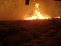
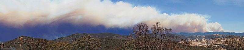
has had a long history of catastrophic bushfires, the most recent of these, the Black Saturday bushfires claiming 173 lives. Legislation, planning, management and suppression are the responsibilities of the Victorian State Government through its departments and agencies including the Country Fire Authority
Country Fire Authority
Country Fire Authority, or CFA, is the name of the fire service that provides firefighting and other emergency services to all of the country areas and regional townships within the state of Victoria, Australia, as well as large portions of the outer suburban areas and growth corridors of Melbourne...
and the Department of Sustainability and Environment.
Fire districts
- Central
- East GippslandEast GippslandEast Gippsland is the eastern region of Gippsland, Australia covering 31,740 square kilometres of Victoria. It has a population of 80,114....
- MalleeThe MalleeThe Mallee is the most northwesterly district in the state of Victoria, and also encompasses the agricultural district of South Australia. Definitions vary, however all are based on the Victorian distribution of mallee eucalypts...
- North CentralNorth central victoriaNorth Central Victoria is a rural region in the Australian state of Victoria.- Location :Sustainability Victoria, a Victorian Government agency, defines North Central Victoria as the municipalities of Buloke, Gannawarra, Loddon, Campaspe, Central Goldfields, Mount Alexander, Macedon Ranges and the...
- Northeast
- Northern Country
- WestWest GippslandWest Gippsland, a region of Gippsland in Victoria, Australia, extends from the southeastern limits of metropolitan Melbourne and Western Port Bay in the west to the Latrobe Valley in the east, and is bounded by the Strzelecki Ranges to the south and the Mount Baw Baw Plateau in the Great Dividing...
& South GippslandSouth GippslandSouth Gippsland, a region of Gippsland in Victoria, Australia, is a well-watered region consisting of low, rolling hills descending to the coast in the south and the Latrobe Valley in the north. Low granite hills continue into Wilsons Promontory, the southernmost point of Victoria and mainland... - Western District
- WimmeraWimmeraThe Wimmera is a region in the west of the Australian state of Victoria.It covers the dryland farming area south of the range of Mallee scrub, east of the South Australia border and north of the Great Dividing Range...
The districts were reconfigured together with weather forecast districts so that they share common alignments. The revised alignments follow Local Government Authority boundaries, except in Yarriambiack Shire
Yarriambiack Shire
The Shire of Yarriambiack is a Local Government Area in Victoria, Australia. It is located in the north-western part of the state. It includes the towns of Hopetoun, Murtoa and Warracknabeal. It has an area of 7,176 square kilometres. In 2006 it had a population of 7,520...
. The new alignments came into effect on 3 November 2010. Total Fire Bans & Fire Danger Ratings
McArthur Forest Fire Danger Index
The McArthur Forest Fire Danger Index was developed in the 1960s by CSIRO scientist A.G. McArthur to measure the degree of danger of fire in Australian forests. The index combines a record of dryness, based on rainfall and evaporation, with meteorological variables for windspeed, temperature and...
maps reflect predictions of the relative danger of bushfire conditions in each district and are communicated to the general public through weather forecasts and the Country Fire Authority
Country Fire Authority
Country Fire Authority, or CFA, is the name of the fire service that provides firefighting and other emergency services to all of the country areas and regional townships within the state of Victoria, Australia, as well as large portions of the outer suburban areas and growth corridors of Melbourne...
and Department of Sustainability and Environment internet sites during the fire season. The ratings are Low-Moderate, High, Very High, Severe, Extreme and Code Red.
Fire management
Suppression
A number of agencies are responsible for bushfire suppression in Victoria - the Country Fire AuthorityCountry Fire Authority
Country Fire Authority, or CFA, is the name of the fire service that provides firefighting and other emergency services to all of the country areas and regional townships within the state of Victoria, Australia, as well as large portions of the outer suburban areas and growth corridors of Melbourne...
(CFA) which is a state-wide volunteer-based organisation, the Department of Sustainability and Environment who who are responsible for public land, covering one third of the state and the Metropolitan Fire Brigade
Metropolitan Fire Brigade (Melbourne)
The Metropolitan Fire Brigade , also known as the Metropolitan Fire and Emergency Services Board, provides firefighting, rescue, and hazardous material incident response services to the metropolitan area of Melbourne, Victoria, Australia...
(MFB), which covers the metropolitan area of Melbourne
Melbourne
Melbourne is the capital and most populous city in the state of Victoria, and the second most populous city in Australia. The Melbourne City Centre is the hub of the greater metropolitan area and the Census statistical division—of which "Melbourne" is the common name. As of June 2009, the greater...
.
Bushfire warnings
Once fires have started, the Country Fire AuthorityCountry Fire Authority
Country Fire Authority, or CFA, is the name of the fire service that provides firefighting and other emergency services to all of the country areas and regional townships within the state of Victoria, Australia, as well as large portions of the outer suburban areas and growth corridors of Melbourne...
(CFA) give graded warnings through various means to areas of settlements that may be affected by the fire. These warnings are distributed as messages detailing the status of the fire, its potential movements and give advice to residents in areas that may be affected. They are as follows:
Emergency Alert
Emergency Alert Australia
Emergency Alert Australia is an emergency communications scheme set up by the Australian Commonwealth Government in response to the Black Saturday bushfires of 2009, utilizing telecommunications systems as another form of alert for citizens....
telephone warnings are sent in emergency situations. Landlines in the emergency area receive voice messages and mobile phones (with a billing address in the emergency area) receive text messages. Emergency broadcasts are made on ABC
Australian Broadcasting Corporation
The Australian Broadcasting Corporation, commonly referred to as "the ABC" , is Australia's national public broadcaster...
and commercial radio stations and Sky News
Sky News
Sky News is a 24-hour British and international satellite television news broadcaster with an emphasis on UK and international news stories.The service places emphasis on rolling news, including the latest breaking news. Sky News also hosts localised versions of the channel in Australia and in New...
television. Information can also be sought by telephone from the Victorian Bushfire Information Line. During an emergency, the Standard Emergency Warning Signal
Standard Emergency Warning Signal
The Standard Emergency Warning Signal is a warning siren used in Australia to alert the public of danger. The siren is played over radio, television or public address systems in public places to warn of bushfire, flood, cyclone, tsunami, earthquake or terrorist attack.-Use:The SEWS tone has also...
is played via television, radio and public address systems.
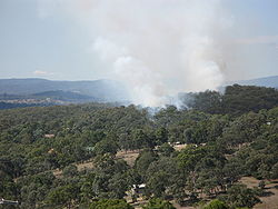
Current bushfire incidents together with all calls for assistance from the Country Fire Authority and the Department Of Sustainability and Environment are listed in incident summaries at their respective websites.
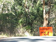
Fuel-reduction burning
Planned burning is carried out by the Department of Sustainability and Environment at certain times of year to reduce fuel levels in parks and reserves throughout the state.Wildfire Management Overlays
Wildfire Management Overlays are areas identified in planning schemes within each of the Local Government Areas of Victoria that are deemed to have a severe forest fire risk. These areas are subject to particular planning and building controls.Vegetation removal
Following the Black Saturday bushfires of 2009, interim measures were introduced by the State Government to permit vegetation removal in bushfire prone areas. The exemptions include removal of vegetation (including trees) within 10 metres of existing residences as well as all vegetation (excluding trees) within 30 metres. The measures expire on 1 March 2012.Building standards
The Victorian Government has adopted the residential building Australian StandardStandards Australia
Standards Australia was established in 1922 and is recognised through a Memorandum of Understanding with the Australian government as the peak non-government standards development body in Australia. It is a company limited by guarantee, with 72 members representing groups interested in the...
3959-20099 to cover the location, design, construction of new dwellings in bushfire prone areas. The new standard includes consideration of Bushfire Attack Levels which are based on a number of factors including slope, proximity of vegetation and Fire Danger Index
McArthur Forest Fire Danger Index
The McArthur Forest Fire Danger Index was developed in the 1960s by CSIRO scientist A.G. McArthur to measure the degree of danger of fire in Australian forests. The index combines a record of dryness, based on rainfall and evaporation, with meteorological variables for windspeed, temperature and...
. New interim regulations have also been introduced for the construction of private bushfire shelters or bunkers.
Township Protection Plans
Township Protection Plans are strategies developed to provide a planned response to bushfire emergencies for 52 locations in Victoria that are deemed to be in high risk areas. The plans include community information, township planning factors and fire prevention strategies. Some of these plans include designated Neighbourhood Safer Places which are sanctuaries of "last resort" during a bushfire emergency.Common causes
Common causes of bushfire, figures for Victoria over a 20-year period. Lightning is the most common cause, igniting the highest number of bushfires, which subsequently account for nearly half of the area burnt by bushfires in the state. Deliberately lit fires are the next most common, although burn much less area than fires ignited by lightning. Public utilities, such as powerlines, ignite relatively few fires, but these subsequently burn similar area to that of deliberately lit fires.Cigarettes, matches and such, ignite a fair few fires, mostly in and around urban areas, and thus burn small areas of land as they are attended to more easily in the more accessible terrain. Many fires are caused by many other less common ignition sources or have unknown causes.
By number of fires
- LightningLightningLightning is an atmospheric electrostatic discharge accompanied by thunder, which typically occurs during thunderstorms, and sometimes during volcanic eruptions or dust storms...
- 26% - Deliberate - 25%
- Agricultural - 16%
- Campfire - 10%
- Cigarettes/Matches - 7%
- Unknown Causes - 6%
- Misc - 5%
- Machinery/Exhausts - 3%
- Planned burn escapes - 2%
- Public Utilities - 1%
By area burnt
- LightningLightningLightning is an atmospheric electrostatic discharge accompanied by thunder, which typically occurs during thunderstorms, and sometimes during volcanic eruptions or dust storms...
- 46% - Public Utilities - 14%
- Deliberate - 14%
- Misc - 9%
- Agricultural - 7%
- Planned burn escapes - 5%
- Unknown Causes - 3%
- Machinery/Exhaust - 2%
- Campfire - 1%
- Cigarettes/Matches - less than 1%
Major Victorian Bushfires
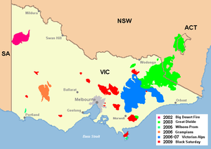
Most extensive fires
- 1851 - 6 February "Black Thursday" (5 million hectares)
- 1938-39 - December - January "Black FridayBlack Friday (1939)The Black Friday fires of 13 January 1939, in Victoria, Australia, were considered one of the worst natural bushfires in the world, and certainly the single worst in Australian history as a measure of land affected...
" (2 million hectares) - 2003 - January - March "2003 Eastern Victorian alpine bushfires2003 Eastern Victorian alpine bushfiresThe Eastern Victorian alpine bushfires, also known as the Great Divide Fire Complex, started with eighty seven fires that were started by lightning in the north east of Victoria on 8 January 2003...
" (1.3 million hectares) - 2006-07 - December - February "Victorian Alps Fire Complex" (1.1 million hectares)
- 1944 - January - February (1 million hectares)
- 1983 - 16 February "Ash WednesdayAsh Wednesday firesThe Ash Wednesday bushfires, known in South Australia as Ash Wednesday II, were a series of bushfires that occurred in south-eastern Australia on 16 February 1983. Within twelve hours, more than 180 fires fanned by winds of up to 110 km per hour caused widespread destruction across the states...
" (510,000 hectares) - 2009 - 7 February "Black Saturday" (450,000 hectares)
- 1965 - Gippsland (300,000 hectares)
- 1898 - 1 February "Red TuesdayRed TuesdayThe Red Tuesday bushfires took place on February 1, 1898 in South Gippsland, Victoria. The bushfires claimed 12 lives, destroyed over 2,000 buildings and affected about 15,000 people, leaving 2,500 homeless.-External links:...
" (260,000 hectares)
Deadliest fires
- 2009 - 7 February - March "Black Saturday" (173 deaths)
- 1939 - December - January "Black FridayBlack Friday (1939)The Black Friday fires of 13 January 1939, in Victoria, Australia, were considered one of the worst natural bushfires in the world, and certainly the single worst in Australian history as a measure of land affected...
" (71 deaths) - 1926 - 14 February - March "Black Sunday1925-26 Victorian bushfire seasonDuring the 1925–26 Victorian bushfire season a series of major bushfires occurred between 26 January and 10 March 1926 in the state of Victoria in Australia...
" (60 deaths) - 1944 - December - February1943-44 Victorian bushfire seasonThe 1943-44 Victorian bushfire season was marked by a series of major bushfires following severe drought conditions in the state of Victoria in Australia. The summer of 1943-44 was the driest summer ever recorded in Melbourne with just 46 mm falling, a third of the average for the period...
(51 deaths) - 1983 - 16 February "Ash WednesdayAsh Wednesday firesThe Ash Wednesday bushfires, known in South Australia as Ash Wednesday II, were a series of bushfires that occurred in south-eastern Australia on 16 February 1983. Within twelve hours, more than 180 fires fanned by winds of up to 110 km per hour caused widespread destruction across the states...
" (47 in Victoria) - 1962 - 14–16 January (33 deaths)
- 1969 - 8 January (23 deaths)
- 1942 - Western Victoria (20 deaths)
- 1905 - 1 December (12 deaths)
- 1898 - 1 February "Red TuesdayRed TuesdayThe Red Tuesday bushfires took place on February 1, 1898 in South Gippsland, Victoria. The bushfires claimed 12 lives, destroyed over 2,000 buildings and affected about 15,000 people, leaving 2,500 homeless.-External links:...
" (12 deaths) - 1851 - 6 February "Black Thursday" (12 deaths)
- 1943 - 22 December (10 deaths)
- 1952 - January - March, Central Victoria (10 deaths)
- 1977 - 12 February, Western Victoria (8 deaths)
External links
- State Library of Victoria's Bushfires in Victoria Research Guide Guide to locating books, government reports, websites, statistics, newspaper reports and images about Victorian bushfires from 1851 to the present.
- Country Fire Authority
- Department of Sustanability and Environment