

Burry Port
Encyclopedia
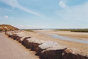
Burry Port is a small town five miles (8 km) outside the larger centre of Llanelli
in Carmarthenshire
, Wales
, lying on the Loughor
estuary. The town's population is roughly 8,000 although in the 2001 census there were 4209 residents.
The town is home to a harbour and is where Amelia Earhart
landed as the first woman to fly across the Atlantic Ocean
. The Pembrey Burrows
sand dune and wetland
system, home to a country park
and the Cefn Sidan
sands, lie nearby. The town also has a proud musical heritage and is also home to Burry Port Opera, Male Choir and Burry Port Town Band
flows the length of the valley and joins the sea at Burry port flowing into the estuary of the Loughor
river (known locally as the "Burry"). West of the town's shoreline is Pembrey Burrows
, a large area of burrow
and marshland which historically occupied many square miles of land, much of which has later been reclaimed. To the north of the town is the hill Mynydd Pembrey, or Pembrey
Mountain.
brought the railways and collieries to the area, As Pembrey Burrows
was a hazard to shipping, local people would also salvage what they could from boats wrecked in storms while navigating the Bristol Channel
.
Pembrey sands have proved the final resting place of many ships, some by mishap, others it is said lured to their doom deliberately to provide plunder for the wreckers known as "Gwyr-y-Bwelli Bach" or "The Men of Little Hatchets". They were named after the locally made tool, a hatchet incorporating a claw for ripping open cargo and equally useful for dispatching unwanted witnesses to the wreckers' activities .
at the time was navigable but treacherous.
Growing interest in coal, limestone and iron ore drove the growth of the coal trade. Thomas Kymer, owner of many mining and other operations in the area established several loading places and primitive trackways to load barges on the Gwendraeth Fawr. Cargo was carried down the Gwendraeth river and then up the Towy to Carmarthen
. In 1768 Kymer opened a canal and quay, part of which is today restored and preserved. The canal cut through the marshes allowing boats to travel upstream far enough to reach solid ground where quays could be built. This allowed barges to operate at all times and without having to wait for tides to get inland. A canal alone was not sufficient to solve the transport problems and wagonways were built to carry traffic from the mines to the canal itself. Several of these wagonways became plateways and then railways as technology improved.
A second canal was cut by the Earl of Ashburnham
in 1798 to serve his mines nearby and this also was fed by wagonways. The canals continued to expand and wharves and dock facilities were built. More mines continued to open further up the valley sending their coal down through the canals to the sea. The trade in coal was hindered heavily however as the shifting sands made the river treacherous and the safe paths changed year by year.
In 1832 a harbour was built at Burry Port, a few years after the nearby harbour at Pembrey
opened. Fed by a series of chaotic canals and wagonways it finally offered a way to ship Gwendraeth coal out by sea. No village or town of Burry Port yet existed. By 1840 the canals feeding Burry Port and their tramways fed coal from the entire Gwendraeth valley down to the sea. Early records of Burry Port as a town appear around 1850, springing up around the new docks adjacent to Pembrey. The importance of the newly emerging town was plain when the railways reached Burry Port, and the station
serving both Pembrey and the new town of Burry Port was built a few hundred yards down from Pembrey at Burry Port
The canal network was now unable to handle the loads from the Gwendraeth valley mines and part of the canal network was converted into the Burry Port and Gwendraeth Valley Railway by the late 1860s with the port continuing to grow in importance and shipping volumes.
still exists and is served by regular services east via Swansea
and Cardiff
to London
and west into Pembrokeshire
.
Burry Port boasts a supermarket, specialist shops, several hairdressers, a beauty and skincare salon, an array of pubs and fast food outlets, a library and a large secondary school.
Glan-y-Mor Comprehensive School (Glan-y-Mor translates as 'The Sea Shore') has approximately 600 pupils (2010). There is also a Welsh primary School - Ysgol Parc y Tywyn, and an English medium infants school and an English medium junior school in the town.
Burry Port lies on the Millennium Coastal Path
from Bynea near Llanelli
to Pembrey Burrows.
The town is also home to a lifeboat station which is situated in Burry Port Harbour.
flew from Newfoundland with co-pilots Wilmer "Bill" Stultz and Louis "Slim" Gordon in a Fokker F7 and on June 18 landed safely in Burry Port, becoming the first woman to fly across the Atlantic. An Amelia Earhart Festival was held in June 2003 to celebrate the 75th anniversary of the landing, and the event is commemorated by engraved flagtones and a plaque in the harbour.
 Road - Burry Port is connected to Llanelli
and Carmarthen
by the A484 road.
Bus/Coach - There are regular local buses running through Burry Port, linking the town with surrounding villages and towns, with a main stop in the town centre opposite the Co-op. Numerous other stops are located around the town.
Rail - Pembrey and Burry Port railway station
is on the West Wales Line
. Westbound services from Burry Port terminate at Carmarthen
or Pembroke Dock
, with less frequent direct services to Fishguard
and Milford Haven
. Eastbound services terminate at Swansea railway station
or Cardiff Central
, with less frequent direct services to Manchester Piccadilly and London Paddington.
Walking And Cycling - Burry Port is connected to the The Millennium Coastal Park which includes a 22 km pedestrian walkway and cycleway along the south coast of Carmarthenshire, providing a link between Bynea, Llanelli and Pembrey Country Park. The Millennium Coastal Path cycleway forms a section of both the Celtic Trail cycle route (part of NCR 47) and the National Cycle Network NCR 4.
Air - Pembrey Airport
is only a few miles east of Burry Port, and is connected to the town by road links. The nearest airport with domestic and international scheduled flights is Cardiff International Airport
.
Llanelli
Llanelli , the largest town in both the county of Carmarthenshire and the preserved county of Dyfed , Wales, sits on the Loughor estuary on the West Wales coast, approximately west-north-west of Swansea and south-east of the county town, Carmarthen. The town is famous for its proud rugby...
in Carmarthenshire
Carmarthenshire
Carmarthenshire is a unitary authority in the south west of Wales and one of thirteen historic counties. It is the 3rd largest in Wales. Its three largest towns are Llanelli, Carmarthen and Ammanford...
, Wales
Wales
Wales is a country that is part of the United Kingdom and the island of Great Britain, bordered by England to its east and the Atlantic Ocean and Irish Sea to its west. It has a population of three million, and a total area of 20,779 km²...
, lying on the Loughor
River Loughor
The River Loughor in Carmarthenshire, Wales has its source at an underground lake at the Black Mountain. It flows past settlements like Ammanford and Hendy in Carmarthenshire and Pontarddulais in Swansea. The river divides Carmarthenshire from Swansea for much of its course and it separates Hendy...
estuary. The town's population is roughly 8,000 although in the 2001 census there were 4209 residents.
The town is home to a harbour and is where Amelia Earhart
Amelia Earhart
Amelia Mary Earhart was a noted American aviation pioneer and author. Earhart was the first woman to receive the U.S. Distinguished Flying Cross, awarded for becoming the first aviatrix to fly solo across the Atlantic Ocean...
landed as the first woman to fly across the Atlantic Ocean
Atlantic Ocean
The Atlantic Ocean is the second-largest of the world's oceanic divisions. With a total area of about , it covers approximately 20% of the Earth's surface and about 26% of its water surface area...
. The Pembrey Burrows
Pembrey Burrows
Pembrey Burrows stretch from Burry Port's harbour area – a former coal port, now a marina – to Pembrey Country Park, a leisure and nature complex that is one of West Wales's leading visitor attraction....
sand dune and wetland
Wetland
A wetland is an area of land whose soil is saturated with water either permanently or seasonally. Wetlands are categorised by their characteristic vegetation, which is adapted to these unique soil conditions....
system, home to a country park
Country park
A country park is an area designated for people to visit and enjoy recreation in a countryside environment.-History:In the United Kingdom the term 'Country Park' has a special meaning. There are over 400 Country Parks in England alone . Most Country Parks were designated in the 1970s, under the...
and the Cefn Sidan
Cefn Sidan
Cefn Sidan, roughly translated from Welsh, means "Silky Back". This long sandy beach and its dunes form the outer edge of the Pembrey Burrows between Burry Port and Kidwelly, looking southwards over Carmarthen Bay in South Wales....
sands, lie nearby. The town also has a proud musical heritage and is also home to Burry Port Opera, Male Choir and Burry Port Town Band
Geography
Burry Port lies at the end of the Gwendraeth valley which runs north easterly from Burry Port for about twelve miles (19 km). The land around the valley itself contains large amounts of coal as well as limestone. The Gwendraeth FawrRiver Gwendraeth
The River Gwendraeth is a river in Carmarthenshire in west Wales.It has two almost equal branches that have their confluence in their joint estuary at Carmarthen Bay...
flows the length of the valley and joins the sea at Burry port flowing into the estuary of the Loughor
Loughor
Loughor is a town in the City and County of Swansea, Wales, within the historic county boundaries of Glamorgan, Wales. It lies on the estuary of the River Loughor. The town has a community council called Llwchwr....
river (known locally as the "Burry"). West of the town's shoreline is Pembrey Burrows
Pembrey Burrows
Pembrey Burrows stretch from Burry Port's harbour area – a former coal port, now a marina – to Pembrey Country Park, a leisure and nature complex that is one of West Wales's leading visitor attraction....
, a large area of burrow
Burrow
A burrow is a hole or tunnel dug into the ground by an animal to create a space suitable for habitation, temporary refuge, or as a byproduct of locomotion. Burrows provide a form of shelter against predation and exposure to the elements, so the burrowing way of life is quite popular among the...
and marshland which historically occupied many square miles of land, much of which has later been reclaimed. To the north of the town is the hill Mynydd Pembrey, or Pembrey
Pembrey
Pembrey is a village in Carmarthenshire Wales, situated between Burry Port and Kidwelly, overlooking Carmarthen Bay.-History:The name Pembrey is an Anglicisation of the Welsh, Pen-bre...
Mountain.
Early History
People made a living in Burry Port from farming and fishing before the industrial revolutionIndustrial Revolution
The Industrial Revolution was a period from the 18th to the 19th century where major changes in agriculture, manufacturing, mining, transportation, and technology had a profound effect on the social, economic and cultural conditions of the times...
brought the railways and collieries to the area, As Pembrey Burrows
Pembrey Burrows
Pembrey Burrows stretch from Burry Port's harbour area – a former coal port, now a marina – to Pembrey Country Park, a leisure and nature complex that is one of West Wales's leading visitor attraction....
was a hazard to shipping, local people would also salvage what they could from boats wrecked in storms while navigating the Bristol Channel
Bristol Channel
The Bristol Channel is a major inlet in the island of Great Britain, separating South Wales from Devon and Somerset in South West England. It extends from the lower estuary of the River Severn to the North Atlantic Ocean...
.
Pembrey sands have proved the final resting place of many ships, some by mishap, others it is said lured to their doom deliberately to provide plunder for the wreckers known as "Gwyr-y-Bwelli Bach" or "The Men of Little Hatchets". They were named after the locally made tool, a hatchet incorporating a claw for ripping open cargo and equally useful for dispatching unwanted witnesses to the wreckers' activities .
Industrial History
Records indicate that coal mining was established in the valley as early as 1540 although there was little effective transport. The Gwendraeth FawrRiver Gwendraeth
The River Gwendraeth is a river in Carmarthenshire in west Wales.It has two almost equal branches that have their confluence in their joint estuary at Carmarthen Bay...
at the time was navigable but treacherous.
Growing interest in coal, limestone and iron ore drove the growth of the coal trade. Thomas Kymer, owner of many mining and other operations in the area established several loading places and primitive trackways to load barges on the Gwendraeth Fawr. Cargo was carried down the Gwendraeth river and then up the Towy to Carmarthen
Carmarthen
Carmarthen is a community in, and the county town of, Carmarthenshire, Wales. It is sited on the River Towy north of its mouth at Carmarthen Bay. In 2001, the population was 14,648....
. In 1768 Kymer opened a canal and quay, part of which is today restored and preserved. The canal cut through the marshes allowing boats to travel upstream far enough to reach solid ground where quays could be built. This allowed barges to operate at all times and without having to wait for tides to get inland. A canal alone was not sufficient to solve the transport problems and wagonways were built to carry traffic from the mines to the canal itself. Several of these wagonways became plateways and then railways as technology improved.
A second canal was cut by the Earl of Ashburnham
Earl of Ashburnham
The title Baron Ashburnham , of Ashburnham in the County of Sussex, was created in the Peerage of England in 1689 for John Ashburnham, grandson of the John Ashburnham who assisted King Charles I to escape from Oxford and Hampton Court Palace...
in 1798 to serve his mines nearby and this also was fed by wagonways. The canals continued to expand and wharves and dock facilities were built. More mines continued to open further up the valley sending their coal down through the canals to the sea. The trade in coal was hindered heavily however as the shifting sands made the river treacherous and the safe paths changed year by year.
In 1832 a harbour was built at Burry Port, a few years after the nearby harbour at Pembrey
Pembrey
Pembrey is a village in Carmarthenshire Wales, situated between Burry Port and Kidwelly, overlooking Carmarthen Bay.-History:The name Pembrey is an Anglicisation of the Welsh, Pen-bre...
opened. Fed by a series of chaotic canals and wagonways it finally offered a way to ship Gwendraeth coal out by sea. No village or town of Burry Port yet existed. By 1840 the canals feeding Burry Port and their tramways fed coal from the entire Gwendraeth valley down to the sea. Early records of Burry Port as a town appear around 1850, springing up around the new docks adjacent to Pembrey. The importance of the newly emerging town was plain when the railways reached Burry Port, and the station
Pembrey and Burry Port railway station
Pembrey and Burry Port railway station is a railway station on the West Wales Line serving Pembrey and Burry Port, in Carmarthenshire, Wales.There is an hourly service to Manchester Piccadilly via Swansea, Cardiff Central, Shrewsbury and Crewe....
serving both Pembrey and the new town of Burry Port was built a few hundred yards down from Pembrey at Burry Port
The canal network was now unable to handle the loads from the Gwendraeth valley mines and part of the canal network was converted into the Burry Port and Gwendraeth Valley Railway by the late 1860s with the port continuing to grow in importance and shipping volumes.
Present Day
With the closure of all the mines at Cwm Mawr the railways up the valley have been lifted. The harbour is now a marina for small leisure craft. Pembrey and Burry Port railway stationPembrey and Burry Port railway station
Pembrey and Burry Port railway station is a railway station on the West Wales Line serving Pembrey and Burry Port, in Carmarthenshire, Wales.There is an hourly service to Manchester Piccadilly via Swansea, Cardiff Central, Shrewsbury and Crewe....
still exists and is served by regular services east via Swansea
Swansea
Swansea is a coastal city and county in Wales. Swansea is in the historic county boundaries of Glamorgan. Situated on the sandy South West Wales coast, the county area includes the Gower Peninsula and the Lliw uplands...
and Cardiff
Cardiff
Cardiff is the capital, largest city and most populous county of Wales and the 10th largest city in the United Kingdom. The city is Wales' chief commercial centre, the base for most national cultural and sporting institutions, the Welsh national media, and the seat of the National Assembly for...
to London
London
London is the capital city of :England and the :United Kingdom, the largest metropolitan area in the United Kingdom, and the largest urban zone in the European Union by most measures. Located on the River Thames, London has been a major settlement for two millennia, its history going back to its...
and west into Pembrokeshire
Pembrokeshire
Pembrokeshire is a county in the south west of Wales. It borders Carmarthenshire to the east and Ceredigion to the north east. The county town is Haverfordwest where Pembrokeshire County Council is headquartered....
.
Burry Port boasts a supermarket, specialist shops, several hairdressers, a beauty and skincare salon, an array of pubs and fast food outlets, a library and a large secondary school.
Glan-y-Mor Comprehensive School (Glan-y-Mor translates as 'The Sea Shore') has approximately 600 pupils (2010). There is also a Welsh primary School - Ysgol Parc y Tywyn, and an English medium infants school and an English medium junior school in the town.
Burry Port lies on the Millennium Coastal Path
Millennium coastal path
The Millennium Coastal Path is a 22 km pedestrian walkway and cycleway along the south coast of Carmarthenshire, providing a link between Llanelli and Pembrey Country Park. The cycleway forms a section of both the Celtic Trail cycle route and the National Cycle Network NCN 4.The Millennium...
from Bynea near Llanelli
Llanelli
Llanelli , the largest town in both the county of Carmarthenshire and the preserved county of Dyfed , Wales, sits on the Loughor estuary on the West Wales coast, approximately west-north-west of Swansea and south-east of the county town, Carmarthen. The town is famous for its proud rugby...
to Pembrey Burrows.
The town is also home to a lifeboat station which is situated in Burry Port Harbour.
Amelia Earhart Landing
On June 17, 1928 Amelia EarhartAmelia Earhart
Amelia Mary Earhart was a noted American aviation pioneer and author. Earhart was the first woman to receive the U.S. Distinguished Flying Cross, awarded for becoming the first aviatrix to fly solo across the Atlantic Ocean...
flew from Newfoundland with co-pilots Wilmer "Bill" Stultz and Louis "Slim" Gordon in a Fokker F7 and on June 18 landed safely in Burry Port, becoming the first woman to fly across the Atlantic. An Amelia Earhart Festival was held in June 2003 to celebrate the 75th anniversary of the landing, and the event is commemorated by engraved flagtones and a plaque in the harbour.
Transport
Llanelli
Llanelli , the largest town in both the county of Carmarthenshire and the preserved county of Dyfed , Wales, sits on the Loughor estuary on the West Wales coast, approximately west-north-west of Swansea and south-east of the county town, Carmarthen. The town is famous for its proud rugby...
and Carmarthen
Carmarthen
Carmarthen is a community in, and the county town of, Carmarthenshire, Wales. It is sited on the River Towy north of its mouth at Carmarthen Bay. In 2001, the population was 14,648....
by the A484 road.
Bus/Coach - There are regular local buses running through Burry Port, linking the town with surrounding villages and towns, with a main stop in the town centre opposite the Co-op. Numerous other stops are located around the town.
Rail - Pembrey and Burry Port railway station
Pembrey and Burry Port railway station
Pembrey and Burry Port railway station is a railway station on the West Wales Line serving Pembrey and Burry Port, in Carmarthenshire, Wales.There is an hourly service to Manchester Piccadilly via Swansea, Cardiff Central, Shrewsbury and Crewe....
is on the West Wales Line
West Wales Line
The West Wales Lines are a group of railway lines from Swansea through Carmarthenshire to Pembrokeshire, West Wales...
. Westbound services from Burry Port terminate at Carmarthen
Carmarthen railway station
Carmarthen railway station is situated south of the River Towy on the edge of the town of Carmarthen. It is located on the West Wales Line and is managed by Arriva Trains Wales, who operate most of the passenger trains serving it...
or Pembroke Dock
Pembroke Dock railway station
Pembroke Dock railway station serves the town of Pembroke Dock in Pembrokeshire, Wales.The station is served by a regular daily service to/from Swansea via Whitland, with connections for the South Wales mainline available at Swansea....
, with less frequent direct services to Fishguard
Fishguard Harbour railway station
Fishguard Harbour railway station serves the port of Fishguard Harbour, Wales. It is the terminus of one of the branches of the West Wales Line from Swansea.-Ownership:...
and Milford Haven
Milford Haven railway station
Milford Haven railway station serves the town of Milford Haven in Pembrokeshire, Wales. Opened on 7 September 1863, it was originally known as Milford, becoming Old Milford by January 1902, and finally being renamed Milford Haven by April 1910....
. Eastbound services terminate at Swansea railway station
Swansea railway station
Swansea railway station is a railway station that serves Swansea, Wales. The station is one of four in the City and County of Swansea and is the fourth busiest in Wales after Cardiff Central, Cardiff Queen Street and Newport.-History:...
or Cardiff Central
Cardiff Central railway station
Cardiff Central railway station is a major railway station on the South Wales Main Line in Cardiff, Wales.It is the largest and busiest station in Wales and one of the major stations of the British rail network, the tenth busiest station in the United Kingdom outside of London , based on 2007/08...
, with less frequent direct services to Manchester Piccadilly and London Paddington.
Walking And Cycling - Burry Port is connected to the The Millennium Coastal Park which includes a 22 km pedestrian walkway and cycleway along the south coast of Carmarthenshire, providing a link between Bynea, Llanelli and Pembrey Country Park. The Millennium Coastal Path cycleway forms a section of both the Celtic Trail cycle route (part of NCR 47) and the National Cycle Network NCR 4.
Air - Pembrey Airport
Pembrey Airport
-Former operators:Other airlines that have operated at Pembrey:*Air Wales*Air Independence*Air Winton...
is only a few miles east of Burry Port, and is connected to the town by road links. The nearest airport with domestic and international scheduled flights is Cardiff International Airport
Cardiff International Airport
Cardiff Airport is an international airport serving Cardiff, and the rest of South, Mid and West Wales. Around 1.4 million passengers passed through the airport in 2010....
.
Burry Port Tidal Range
The current sea level depths in the shipping year at Burry Port are the following:| Tide | Height |
|---|---|
| Mean High Water Springs (MHWS) | 8.6 metres (28.2 ft) |
| Mean High Water Neaps (MHWN) | 6.6 metres (21.7 ft) |
| Mean Low Water Neaps (MLWN) | 3 metres (9.8 ft) |
| Mean Low Water Springs (MLWS) | 1.1 metres (3.6 ft) |
External links
- http://www.pembrey-burryport.org.uk/
- http://www.burry-port.co.uk/
- http://www.burryport.org/
- http://www.burryport.net/
- http://www.burryport.org.uk/
- http://www.yourllanelli.org.uk
- http://www.glanymor.carms.sch.uk/
- http://www.burryporttownband.co.uk/ Burry Port Town Band
- http://www.zazzle.co.uk/stephenpeters* Images of burry port
- Ysgol Parc Y Tywyn
- Amelia Earhart at Burry Port Harbour minutes after landing (footage)- Courtesy of British Pathe
- Amelia Earhart leaves Burry Port for Southampton (footage)- Courtesy of British Pathe
- A column is raised at Burry Port to commemorate the landing of Amelia Earhart's trans Atlantic flight (footage)- Courtesy of British Pathe