

Burrough Hill
Encyclopedia
Burrough Hill is an Iron Age
hillfort in Burrough on the Hill
, 7 miles (11.3 km) south of Melton Mowbray
in the English county of Leicestershire
. Situated on a promontory about 200 metres (656.2 ft) above sea level, the site commands views over the surrounding countryside for miles around. There has been human activity in the area since at least the Mesolithic, and the hillfort was founded in the early Iron Age. In the medieval period, after the hillfort was abandoned, the hill was used as farmland. This ended in the 17th century when the parish the hill was in was enclosed
. Traces of ridge and furrow
show where the medieval fields were ploughed. Since the 1930s the site has been the subject of archaeological investigations and renewed excavations under the auspices of the University of Leicester
began in 2010. Part of Burrough Hill Country Park and open to the public, the hillfort is protected as a Scheduled Ancient Monument
.
and Early Iron Age, roughly the start of the first millennium BC. Their purpose and the reason for their emergence in Britain has been the subject of debate. It has been argued that they could have been military sites constructed in response to invasion from continental Europe, sites built by invaders, or a military reaction to social tensions caused by an increasing population and consequent pressure on agriculture. The dominant view since the 1960s has been that the increasing use of iron led to social changes in Britain. Deposits of iron ore were located in different places from the tin and copper ore necessary to make bronze. There were new centres of production and trading patterns shifted, allowing a new social elite to emerge and power passed into the hands of a new group of people. Archaeologist Barry Cunliffe
believes that population increase still played a role and has stated that hillforts
According to archaeologist Dr Jeremy Taylor "sites like Burrough Hill were the nearest thing we have to a town before places like Leicester ever existed".
 The hillfort stands around 200 metres (656.2 ft) above sea level, 7 miles (11.3 km) south of the modern settlement of Melton Mowbray. The hill is an ironstone
promontory. shaped during prehistoric ice ages. The bedrock is marlstone, limestone
containing iron. Although the rock contains iron, the levels are low and little attempt was made to extract it. The iron gives the limestone a distinctive hue, ranging from orange to light brown as the proportion of iron changes across the site. Surrounded by a single ditch and rampart, the hillfort is trapezoidal in shape and covers an area of around 4.8 hectares (11.9 acre). The ramparts, constructed from stone and earth, stand 3 m (9.8 ft) above the interior of the hillfort and would originally have been higher. There is also a counterscarp
5 metre beyond the northern rampart.
The hillfort was entered from the south-east via a gap in the ramparts turned inwards. The gatepassage extends for 45 metres (147.6 ft) into the fort and is flanked by 2 metres (6.6 ft) high banks, although they were probably much higher when they were originally built. The passage would have been faced with stone. A chamber, possibly a guardhouse, 5 by was built into the banks. Timber posts indicate there may have been a wooden gallery above the entrance, allowing people to cross the ramparts next to the entrance. The design, with an extended gatepassage and an adjacent room, has parallels with hillforts to the north such as Eddisbury
in Cheshire and The Wrekin
in Shropshire. An extended entrance, as seen at Burrough Hill, was a common theme in hillfort design and served to increase the time it took to enter. There may have been a second entrance in the south-west of the site. Later activity on the site has caused breaks in the ramparts, but the remains generally survive well.
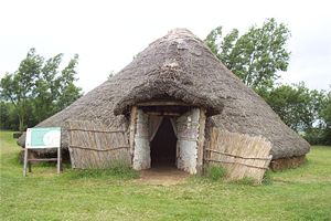
A magnetometry survey of the interior of the hillfort in 2010 revealed over 400 circular anomalies of uncertain purpose (maculae
) distributed across the fort, although there were fewer around the south-east. Their size and number, as well as finds from similar features in previous excavations, suggests they may have been storage pits. The survey also discovered curved features that probably indicate the presence of roundhouse
s. They were grouped close to the ramparts on the north, west, and south sides. There are signs of post-medieval quarrying outside the main entrance to the fort. Outside the hillfort were more curved anomalies, suggesting roundhouses in a settlement beyond the ramparts. It was surrounded by a ditch.
, indicating the area has seen human activity over an extended period of time, however it is likely that a settlement was only created in the Late Bronze or Early Iron Age. The subsequent development of the hillfort is unclear. As yet it is uncertain whether the settlement outside the hillfort was contemporary with the occupation of the hillfort or represent a different phase of activity on the site. The period of most intensive activity at Burrough Hill was between 100 BC and AD 50. Artefacts indicate that the settlement had a wide range of trade links. Towards the end of the Iron Age, the fort gradually degraded. A layer of refuse bears testament to this and contains Roman pottery. It is likely the site was still in use between the 1st and 4th centuries AD, at which point Britain was under Roman control. During the Roman period
, habitation was focused in the northern part of the fort.
In the medieval period, the interior of the hillfort along with the surrounding area was farmed; traces of ridge and furrow
still mark where the fields were ploughed. As well as being used agriculturally, locals used the hill to hold a fair. According to 16th-century antiquarian John Leland, on Whit Monday
s the hill was used for social events such as dancing and games. In his Itinerary, Leland noted that curiosity prompted him to excavate some of the earthworks near the entrance and his account may be regarded as the earliest archaeological field report. The hill was used as farmland until the 17th century when the parish was enclosed. In the 19th century, Burrough Hill was used by the Melton Hunt for steeple-chasing.
The first professional archaeological excavation
on Burrough Hill was in 1935; it was not well recorded, and the exact location of the trench is not certain, but it covered some 33 sqm and was somewhere outside the east of the hillfort. Finds included animal bones and twelve pieces of Iron Age and Roman pottery. Excavations were next undertaken in 1960, by which time new technology meant non-invasive techniques such as magnetometery could be used alongside digging. About half the fort was surveyed using a proton magnetometer. Several features identified through this geophysical
survey were partially excavated; they turned out to be storage pits and produced artefacts such as animal bones, quern stones for grinding, and various shards of Iron Age and Roman pottery. The entrance was also examined, and excavations revealed a cobbled surface leading into the fort as well as what may have been a guardhouse. More animal bone was found here as well as Iron Age and Roman pottery, and a brooch from the La Tène culture
.
Further excavations were undertaken in 1967 when an area 15.25 by was excavated within the northern part of the hillfort with the intention of investigating pit-like features identified in the 1960 magnetometry survey. Finds from the twelve pits consisted of Iron Age and Roman pottery, animal bones, and charcoal. The layer of topsoil above the pits produced Roman pottery and some Roman coins from the 3rd and 4th centuries. The 1960 survey again guided the excavations of 1970 and 1971 when several trenches totalling an area of 63 sqm were dug in the interior near the rampart on the north side of the site. A trench was dug across the rampart to provide a cross-section. Despite multiple excavations, the results have generally been poorly published and as a result the hillfort remains little understood.
The 35 hectares (86.5 acre) country park containing the hillfort has been leased by the Ernest Cook Trust
, who own the site, to Leicestershire County Council
since 1970. The area is still used as farmland, mostly for crops but with some livestock such as cows and sheep. Burrough Hill Country Park, which contains the hillfort, is open to the public in daylight hours.
In 2010 a five-year excavation began on the site, carried out by the University of Leicester School of Archaeology & Ancient History with the University of Leicester Archaeological Services (ULAS). According to Dr Patrick Clay research in the 1990s and 2000s on farmsteads and undefended settlements had revealed much about Iron Age Leicestershire, however the role of hillforts in the county was less clear. The excavations aimed to address the issue of the purpose of hillforts in the region, and also acted as a training dig for students at the university. The hillfort is a Scheduled Monument, which means it is a "nationally important" structure and archaeological site which has been given protection against unauthorised change.
British Iron Age
The British Iron Age is a conventional name used in the archaeology of Great Britain, referring to the prehistoric and protohistoric phases of the Iron-Age culture of the main island and the smaller islands, typically excluding prehistoric Ireland, and which had an independent Iron Age culture of...
hillfort in Burrough on the Hill
Burrough on the Hill
Burrough on the Hill is a small village south of Melton Mowbray, Leicestershire, England.It has a population of between 150-200 and the parish church is St.Mary.Close by is the country park of Burrough Hill, an Iron Age hill fort...
, 7 miles (11.3 km) south of Melton Mowbray
Melton Mowbray
Melton Mowbray is a town in the Melton borough of Leicestershire, England. It is to the northeast of Leicester, and southeast of Nottingham...
in the English county of Leicestershire
Leicestershire
Leicestershire is a landlocked county in the English Midlands. It takes its name from the heavily populated City of Leicester, traditionally its administrative centre, although the City of Leicester unitary authority is today administered separately from the rest of Leicestershire...
. Situated on a promontory about 200 metres (656.2 ft) above sea level, the site commands views over the surrounding countryside for miles around. There has been human activity in the area since at least the Mesolithic, and the hillfort was founded in the early Iron Age. In the medieval period, after the hillfort was abandoned, the hill was used as farmland. This ended in the 17th century when the parish the hill was in was enclosed
Enclosure
Enclosure or inclosure is the process which ends traditional rights such as mowing meadows for hay, or grazing livestock on common land. Once enclosed, these uses of the land become restricted to the owner, and it ceases to be common land. In England and Wales the term is also used for the...
. Traces of ridge and furrow
Ridge and furrow
Ridge and furrow is an archaeological pattern of ridges and troughs created by a system of ploughing used in Europe during the Middle Ages. The earliest examples date to the immediate post-Roman period and the system was used until the 17th century in some areas. Ridge and furrow topography is...
show where the medieval fields were ploughed. Since the 1930s the site has been the subject of archaeological investigations and renewed excavations under the auspices of the University of Leicester
University of Leicester
The University of Leicester is a research-led university based in Leicester, England. The main campus is a mile south of the city centre, adjacent to Victoria Park and Wyggeston and Queen Elizabeth I College....
began in 2010. Part of Burrough Hill Country Park and open to the public, the hillfort is protected as a Scheduled Ancient Monument
Scheduled Ancient Monument
In the United Kingdom, a scheduled monument is a 'nationally important' archaeological site or historic building, given protection against unauthorized change. The various pieces of legislation used for legally protecting heritage assets from damage and destruction are grouped under the term...
.
Background
Hill forts developed in the Late BronzeBronze Age
The Bronze Age is a period characterized by the use of copper and its alloy bronze as the chief hard materials in the manufacture of some implements and weapons. Chronologically, it stands between the Stone Age and Iron Age...
and Early Iron Age, roughly the start of the first millennium BC. Their purpose and the reason for their emergence in Britain has been the subject of debate. It has been argued that they could have been military sites constructed in response to invasion from continental Europe, sites built by invaders, or a military reaction to social tensions caused by an increasing population and consequent pressure on agriculture. The dominant view since the 1960s has been that the increasing use of iron led to social changes in Britain. Deposits of iron ore were located in different places from the tin and copper ore necessary to make bronze. There were new centres of production and trading patterns shifted, allowing a new social elite to emerge and power passed into the hands of a new group of people. Archaeologist Barry Cunliffe
Barry Cunliffe
Sir Barrington Windsor Cunliffe, CBE, known professionally as Barry Cunliffe is a former Professor of European Archaeology at the University of Oxford, a position held from 1972 to 2007...
believes that population increase still played a role and has stated that hillforts
According to archaeologist Dr Jeremy Taylor "sites like Burrough Hill were the nearest thing we have to a town before places like Leicester ever existed".
Location and layout
Ironstone
Ironstone is a sedimentary rock, either deposited directly as a ferruginous sediment or created by chemical repacement, that contains a substantial proportion of an iron compound from which iron either can be or once was smelted commercially. This term is customarily restricted to hard coarsely...
promontory. shaped during prehistoric ice ages. The bedrock is marlstone, limestone
Limestone
Limestone is a sedimentary rock composed largely of the minerals calcite and aragonite, which are different crystal forms of calcium carbonate . Many limestones are composed from skeletal fragments of marine organisms such as coral or foraminifera....
containing iron. Although the rock contains iron, the levels are low and little attempt was made to extract it. The iron gives the limestone a distinctive hue, ranging from orange to light brown as the proportion of iron changes across the site. Surrounded by a single ditch and rampart, the hillfort is trapezoidal in shape and covers an area of around 4.8 hectares (11.9 acre). The ramparts, constructed from stone and earth, stand 3 m (9.8 ft) above the interior of the hillfort and would originally have been higher. There is also a counterscarp
Counterscarp
A scarp and a counterscarp are the inner and outer sides of a ditch used in fortifications. In permanent fortifications the scarp and counterscarp may be encased in stone...
5 metre beyond the northern rampart.
The hillfort was entered from the south-east via a gap in the ramparts turned inwards. The gatepassage extends for 45 metres (147.6 ft) into the fort and is flanked by 2 metres (6.6 ft) high banks, although they were probably much higher when they were originally built. The passage would have been faced with stone. A chamber, possibly a guardhouse, 5 by was built into the banks. Timber posts indicate there may have been a wooden gallery above the entrance, allowing people to cross the ramparts next to the entrance. The design, with an extended gatepassage and an adjacent room, has parallels with hillforts to the north such as Eddisbury
Eddisbury hill fort
Eddisbury hill fort, also known as Castle Ditch, is an Iron Age hill fort near Delamere, Cheshire, in northern England. Hill forts are fortified hill-top settlements constructed across Britain during the Iron Age. Eddisbury is the largest and most complex of the seven hill forts in the county of...
in Cheshire and The Wrekin
The Wrekin
The Wrekin is a hill in east Shropshire, England. It is located some west of Telford, on the border between the unitary authorities of Shropshire and Telford and Wrekin. Rising to a height of above the Shropshire Plain, it is a prominent and well-known landmark, marking the entrance to Shropshire...
in Shropshire. An extended entrance, as seen at Burrough Hill, was a common theme in hillfort design and served to increase the time it took to enter. There may have been a second entrance in the south-west of the site. Later activity on the site has caused breaks in the ramparts, but the remains generally survive well.
A magnetometry survey of the interior of the hillfort in 2010 revealed over 400 circular anomalies of uncertain purpose (maculae
Macula (archaeology)
Macula is a term used by archaeologists to describe small two-dimensional features of ancient human origin visible on an aerial photograph, such as points, spots or patches, which may represent features such as burial places, pits, Grubenhäuser , constructions based on posthole or features above...
) distributed across the fort, although there were fewer around the south-east. Their size and number, as well as finds from similar features in previous excavations, suggests they may have been storage pits. The survey also discovered curved features that probably indicate the presence of roundhouse
Roundhouse
A roundhouse is a building used by railroads for servicing locomotives. Roundhouses are large, circular or semicircular structures that were traditionally located surrounding or adjacent to turntables...
s. They were grouped close to the ramparts on the north, west, and south sides. There are signs of post-medieval quarrying outside the main entrance to the fort. Outside the hillfort were more curved anomalies, suggesting roundhouses in a settlement beyond the ramparts. It was surrounded by a ditch.
History
Burrough Hill is the best example of a univallate hillfort (surrounded by a single ditch and rampart) in Leicestershire. Finds from the site date from as early as the MesolithicMesolithic
The Mesolithic is an archaeological concept used to refer to certain groups of archaeological cultures defined as falling between the Paleolithic and the Neolithic....
, indicating the area has seen human activity over an extended period of time, however it is likely that a settlement was only created in the Late Bronze or Early Iron Age. The subsequent development of the hillfort is unclear. As yet it is uncertain whether the settlement outside the hillfort was contemporary with the occupation of the hillfort or represent a different phase of activity on the site. The period of most intensive activity at Burrough Hill was between 100 BC and AD 50. Artefacts indicate that the settlement had a wide range of trade links. Towards the end of the Iron Age, the fort gradually degraded. A layer of refuse bears testament to this and contains Roman pottery. It is likely the site was still in use between the 1st and 4th centuries AD, at which point Britain was under Roman control. During the Roman period
Roman Britain
Roman Britain was the part of the island of Great Britain controlled by the Roman Empire from AD 43 until ca. AD 410.The Romans referred to the imperial province as Britannia, which eventually comprised all of the island of Great Britain south of the fluid frontier with Caledonia...
, habitation was focused in the northern part of the fort.
In the medieval period, the interior of the hillfort along with the surrounding area was farmed; traces of ridge and furrow
Ridge and furrow
Ridge and furrow is an archaeological pattern of ridges and troughs created by a system of ploughing used in Europe during the Middle Ages. The earliest examples date to the immediate post-Roman period and the system was used until the 17th century in some areas. Ridge and furrow topography is...
still mark where the fields were ploughed. As well as being used agriculturally, locals used the hill to hold a fair. According to 16th-century antiquarian John Leland, on Whit Monday
Whit Monday
Whit Monday or Pentecost Monday is the holiday celebrated the day after Pentecost, a movable feast in the Christian calendar. It is movable because it is determined by the date of Easter....
s the hill was used for social events such as dancing and games. In his Itinerary, Leland noted that curiosity prompted him to excavate some of the earthworks near the entrance and his account may be regarded as the earliest archaeological field report. The hill was used as farmland until the 17th century when the parish was enclosed. In the 19th century, Burrough Hill was used by the Melton Hunt for steeple-chasing.
The first professional archaeological excavation
Archaeological site
An archaeological site is a place in which evidence of past activity is preserved , and which has been, or may be, investigated using the discipline of archaeology and represents a part of the archaeological record.Beyond this, the definition and geographical extent of a 'site' can vary widely,...
on Burrough Hill was in 1935; it was not well recorded, and the exact location of the trench is not certain, but it covered some 33 sqm and was somewhere outside the east of the hillfort. Finds included animal bones and twelve pieces of Iron Age and Roman pottery. Excavations were next undertaken in 1960, by which time new technology meant non-invasive techniques such as magnetometery could be used alongside digging. About half the fort was surveyed using a proton magnetometer. Several features identified through this geophysical
Geophysics
Geophysics is the physics of the Earth and its environment in space; also the study of the Earth using quantitative physical methods. The term geophysics sometimes refers only to the geological applications: Earth's shape; its gravitational and magnetic fields; its internal structure and...
survey were partially excavated; they turned out to be storage pits and produced artefacts such as animal bones, quern stones for grinding, and various shards of Iron Age and Roman pottery. The entrance was also examined, and excavations revealed a cobbled surface leading into the fort as well as what may have been a guardhouse. More animal bone was found here as well as Iron Age and Roman pottery, and a brooch from the La Tène culture
La Tène culture
The La Tène culture was a European Iron Age culture named after the archaeological site of La Tène on the north side of Lake Neuchâtel in Switzerland, where a rich cache of artifacts was discovered by Hansli Kopp in 1857....
.
Further excavations were undertaken in 1967 when an area 15.25 by was excavated within the northern part of the hillfort with the intention of investigating pit-like features identified in the 1960 magnetometry survey. Finds from the twelve pits consisted of Iron Age and Roman pottery, animal bones, and charcoal. The layer of topsoil above the pits produced Roman pottery and some Roman coins from the 3rd and 4th centuries. The 1960 survey again guided the excavations of 1970 and 1971 when several trenches totalling an area of 63 sqm were dug in the interior near the rampart on the north side of the site. A trench was dug across the rampart to provide a cross-section. Despite multiple excavations, the results have generally been poorly published and as a result the hillfort remains little understood.
The 35 hectares (86.5 acre) country park containing the hillfort has been leased by the Ernest Cook Trust
Ernest Cook Trust
The Ernest Cook Trust is a large educational charity in England. It was founded in 1952 by the philanthropist Ernest Cook, the grandson of Thomas Cook...
, who own the site, to Leicestershire County Council
Leicestershire County Council
Leicestershire County Council is the county council for the English non-metropolitan county of Leicestershire. It was originally formed in 1889 by the Local Government Act 1888. The county is divided into 52 electoral divisions, which return a total of 55 councillors. The council is controlled by...
since 1970. The area is still used as farmland, mostly for crops but with some livestock such as cows and sheep. Burrough Hill Country Park, which contains the hillfort, is open to the public in daylight hours.
In 2010 a five-year excavation began on the site, carried out by the University of Leicester School of Archaeology & Ancient History with the University of Leicester Archaeological Services (ULAS). According to Dr Patrick Clay research in the 1990s and 2000s on farmsteads and undefended settlements had revealed much about Iron Age Leicestershire, however the role of hillforts in the county was less clear. The excavations aimed to address the issue of the purpose of hillforts in the region, and also acted as a training dig for students at the university. The hillfort is a Scheduled Monument, which means it is a "nationally important" structure and archaeological site which has been given protection against unauthorised change.
See also
- Hallaton TreasureHallaton TreasureThe Hallaton Treasure, the largest hoard of British Iron Age coins, was discovered in 2000 near Hallaton in southeast Leicestershire, England, by volunteers from the Hallaton Fieldwork Group...
– a large hoard of Iron Age treasure discovered in Leicestershire - Hillforts in BritainHillforts in BritainHillforts in Britain refers to the various hillforts within the island of Great Britain. Although the earliest such constructs fitting this description come from the Neolithic period, with a few also dating to the later Bronze Age, British hill forts were primarily constructed during the Iron Age...