
Winona County, Minnesota
Encyclopedia
Census
A census is the procedure of systematically acquiring and recording information about the members of a given population. It is a regularly occurring and official count of a particular population. The term is used mostly in connection with national population and housing censuses; other common...
of 2000, there were 49,985 people, 18,744 households, and 11,696 families residing in the county. The population density
Population density
Population density is a measurement of population per unit area or unit volume. It is frequently applied to living organisms, and particularly to humans...
was 80 people per square mile (31/km²). There were 19,551 housing units at an average density of 31 per square mile (12/km²). The racial makeup of the county was 95.80% White
Race (United States Census)
Race and ethnicity in the United States Census, as defined by the Federal Office of Management and Budget and the United States Census Bureau, are self-identification data items in which residents choose the race or races with which they most closely identify, and indicate whether or not they are...
, 0.77% Black
Race (United States Census)
Race and ethnicity in the United States Census, as defined by the Federal Office of Management and Budget and the United States Census Bureau, are self-identification data items in which residents choose the race or races with which they most closely identify, and indicate whether or not they are...
or African American
Race (United States Census)
Race and ethnicity in the United States Census, as defined by the Federal Office of Management and Budget and the United States Census Bureau, are self-identification data items in which residents choose the race or races with which they most closely identify, and indicate whether or not they are...
, 0.19% Native American
Race (United States Census)
Race and ethnicity in the United States Census, as defined by the Federal Office of Management and Budget and the United States Census Bureau, are self-identification data items in which residents choose the race or races with which they most closely identify, and indicate whether or not they are...
, 1.87% Asian
Race (United States Census)
Race and ethnicity in the United States Census, as defined by the Federal Office of Management and Budget and the United States Census Bureau, are self-identification data items in which residents choose the race or races with which they most closely identify, and indicate whether or not they are...
, 0.02% Pacific Islander
Race (United States Census)
Race and ethnicity in the United States Census, as defined by the Federal Office of Management and Budget and the United States Census Bureau, are self-identification data items in which residents choose the race or races with which they most closely identify, and indicate whether or not they are...
, 0.53% from other races
Race (United States Census)
Race and ethnicity in the United States Census, as defined by the Federal Office of Management and Budget and the United States Census Bureau, are self-identification data items in which residents choose the race or races with which they most closely identify, and indicate whether or not they are...
, and 0.81% from two or more races. 1.37% of the population were Hispanic
Race (United States Census)
Race and ethnicity in the United States Census, as defined by the Federal Office of Management and Budget and the United States Census Bureau, are self-identification data items in which residents choose the race or races with which they most closely identify, and indicate whether or not they are...
or Latino
Race (United States Census)
Race and ethnicity in the United States Census, as defined by the Federal Office of Management and Budget and the United States Census Bureau, are self-identification data items in which residents choose the race or races with which they most closely identify, and indicate whether or not they are...
of any race. 41.8% were of German, 13.9% Norwegian, 9.9% Polish and 7.4% Irish
Irish people
The Irish people are an ethnic group who originate in Ireland, an island in northwestern Europe. Ireland has been populated for around 9,000 years , with the Irish people's earliest ancestors recorded having legends of being descended from groups such as the Nemedians, Fomorians, Fir Bolg, Tuatha...
ancestry according to Census 2000.
There were 18,744 households out of which 30.20% had children under the age of 18 living with them, 51.30% were married couples
Marriage
Marriage is a social union or legal contract between people that creates kinship. It is an institution in which interpersonal relationships, usually intimate and sexual, are acknowledged in a variety of ways, depending on the culture or subculture in which it is found...
living together, 7.80% had a female householder with no husband present, and 37.60% were non-families. 28.20% of all households were made up of individuals and 10.50% had someone living alone who was 65 years of age or older. The average household size was 2.46 and the average family size was 3.04.
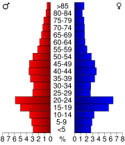
In the county the population was spread out with 22.80% under the age of 18, 18.60% from 18 to 24, 25.10% from 25 to 44, 20.50% from 45 to 64, and 13.10% who were 65 years of age or older. The median age was 33 years. For every 100 females there were 95.20 males. For every 100 females age 18 and over, there were 91.80 males.
The median income for a household in the county was $38,700, and the median income for a family was $49,845. Males had a median income of $31,926 versus $23,406 for females. The per capita income
Per capita income
Per capita income or income per person is a measure of mean income within an economic aggregate, such as a country or city. It is calculated by taking a measure of all sources of income in the aggregate and dividing it by the total population...
for the county was $18,077. About 5.60% of families and 12.00% of the population were below the poverty line, including 9.80% of those under age 18 and 9.30% of those age 65 or over.
Politics
| Year | GOP Republican Party (United States) The Republican Party is one of the two major contemporary political parties in the United States, along with the Democratic Party. Founded by anti-slavery expansion activists in 1854, it is often called the GOP . The party's platform generally reflects American conservatism in the U.S... |
Dems Democratic Party (United States) The Democratic Party is one of two major contemporary political parties in the United States, along with the Republican Party. The party's socially liberal and progressive platform is largely considered center-left in the U.S. political spectrum. The party has the lengthiest record of continuous... |
|---|---|---|
| 2004 | 46.3% 12,686 | 51.9% 14,231 |
| 2000 | 45.0% 10,773 | 46.3% 11,069 |
| 1996 | 36.8% 7,955 | 47.5% 10,272 |
| 1992 | 35.0% 8,585 | 39.6% 9,707 |
| 1988 | 50.9% 11,012 | 47.7% 10,310 |
| 1984 | 55.0% 11,981 | 44.0% 9,577 |
| 1980 | 45.1% 10,332 | 42.9% 9,814 |
| 1976 | 47.6% 10,436 | 49.9% 10,939 |
| 1972 | 56.4% 10,910 | 41.8% 8,080 |
| 1968 | 45.9% 7,998 | 49.5% 8,627 |
| 1964 | 35.7% 6,345 | 64.1% 11,397 |
| 1960 | 52.1% 9,271 | 47.7% 8,484 |
Communities
| Cities | Townships | Unincorporated | ||
|---|---|---|---|---|
|
|
Wilson Township, Winona County, Minnesota Wilson Township is a township in Winona County, Minnesota, United States. The population was 1,152 at the 2000 census.-Geography:According to the United States Census Bureau, the township has a total area of 35.0 square miles , all of it land.-Demographics:As of the census of 2000, there were... |
Ashton, Minnesota Ashton is an abandoned townsite in sections 11 and 12 of Pleasant Hill Township in Winona County, Minnesota, United States. -History:It was reportedly on or near present day County Road 12 about 1.5 miles east-north-east of Ridgeway, Minnesota, but it is unclear whether any vestiges of the... Beaver, Minnesota Beaver is a small unincorporated community in Winona County, Minnesota, United States.-History:Beaver was settled in 1854, by people from New England. It is the oldest village in the Whitewater valley. It was platted in 1856 by Albert Hopson, Dr. Sheldon Brooks, and William J. Duley, as 20 blocks... Bethany, Minnesota Bethany is an unincorporated community located in Winona County, Minnesota at latitude 44.024 and longitude -91.912 . The elevation is 1,217 feet. Bethany appears on the Altura U.S. Geological Survey Map.... Clyde, Minnesota Clyde is an unincorporated community located in Winona County, Minnesota at latitude 43.895 and longitude -91.979 . The elevation is 1,165 feet. Clyde appears on the Utica U.S... Donehower, Minnesota Donehower is an unincorporated community located in Winona County, Minnesota at latitude 43.961 and longitude -91.407 . The elevation is 679 feet. Donehower appears on the Pickwick U.S. Geological Survey Map.... Enterprise, Minnesota Enterprise is an abandoned townsite in section 36 of Utica Township, in Winona County, Minnesota, United States.-History:Enterprise was founded by Alexander Whittier, who established three inns at the roadside in the 1850s. A mill and dam were built by Nathan B. Ufford in 1854, and a post office... Fremont, Minnesota Fremont is an unincorporated community located in Winona County, Minnesota at latitude 43.914 and longitude -91.899 . The elevation is 1,184 feet. Fremont appears on the Utica U.S. Geological Survey Map.... Grover, Minnesota Grover is an abandoned townsite in section 29 of Fremont Township in Winona County, Minnesota, United States.-References:... Homer, Minnesota Homer is an unincorporated community in Winona County, Minnesota, United States. It is located to the southeast of the city of Winona along the Mississippi River at on the southern shore of the Mississippi River.-External links:***... |
Nodine, Minnesota Nodine is an unincorporated community in Winona County, Minnesota, United States.-Geography:Nodine is located on Winona County Highway 12 and the Apple Blossom Scenic Drive, approximately 1 mile south of Interstate Highway 90, within Richard J... Pickwick, Minnesota Pickwick is an unincorporated community located in Winona County, Minnesota at latitude 43.982 and longitude -91.495 . The elevation is 709 feet. Pickwick appears on the Pickwick U.S. Geological Survey Map.... Pine Creek, Minnesota Pine Creek is an unincorporated community located in Houston and Winona counties of Minnesota at latitude 43.845 and longitude -91.403 . The elevation is 709 feet. Pine Creek appears on the Mound Prairie U.S. Geological Survey Map.-External links:*... Ridgeway, Minnesota Ridgeway is an unincorporated community located in Winona County, Minnesota at latitude 43.912 and longitude -91.56 . The elevation is 1,342 feet. Ridgeway appears on the Witoka U.S. Geological Survey Map.... Saratoga, Minnesota Saratoga is an unincorporated community located in Winona County, Minnesota at latitude 43.892 and longitude -92.07 . The elevation is 1,073 feet. Saratoga appears on the Saint Charles U.S. Geological Survey Map.... Troy, Minnesota Troy is an unincorporated community located in Winona County, Minnesota at latitude 43.871 and longitude -92.068 . The elevation is 1,037 feet. Troy appears on the Pilot Mound U.S. Geological Survey Map.-External links:*... Whitewater Falls, Minnesota Whitewater Falls is an abandoned townsite in sections 27 and 34 of Whitewater Township in Winona County, Minnesota.-References:... Wilson, Minnesota Wilson is an unincorporated community located in Winona County, Minnesota at latitude 43.96 and longitude -91.685 . The elevation is 1,339 feet. Wilson appears on the Wilson U.S. Geological Survey Map.-External links:*... Witoka, Minnesota Witoka is an unincorporated community located in Winona County, Minnesota at latitude 43.933 and longitude -91.62 . The elevation is 1,332 feet. Witoka appears on the Witoka U.S. Geological Survey Map.-External links:*... Wyattville, Minnesota Wyattville is an unincorporated community located in Winona County, Minnesota at latitude 43.941 and longitude -91.79 . The elevation is 1,243 feet. Wyattville appears on the Lewiston U.S. Geological Survey Map.... |
† La Crescent is in Houston County
Houston County, Minnesota
As of the census of 2000, there were 19,718 people, 7,633 households, and 5,411 families residing in the county. The population density was 35 people per square mile . There were 8,168 housing units at an average density of 15 per square mile...
but extends into Winona County.
‡ Minneiska is located in both Winona County and Wabasha County
Wabasha County, Minnesota
As of the census of 2000, there were 21,610 people, 8,277 households, and 5,876 families residing in the county. The population density was 41 people per square mile . There were 9,066 housing units at an average density of 17 per square mile...
.