
Broken Top
Encyclopedia
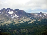
Broken Top is an extinct, glacially eroded stratovolcano
in Oregon
, part of the extensive Cascade Range
. Located south of the Three Sisters
peaks, the volcano, residing within the Three Sisters Wilderness
, is 20 miles (32 km) west of Bend, Oregon
in Deschutes County
. Eruptive activity stopped roughly 100,000 years ago, and currently, erosion by glaciers has reduced the volcano's cone to where its contents are exposed.
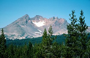 Due to extensive erosion, the contents of Broken Top's cone are exposed, and allow volcanologists to classify Broken Top as a complex stratovolcano. Its initial eruptions during the Pleistocene, consisting of basaltic andesite
lava, contributed to a base shield. The center of this edifice consists of agglomerate, which was oxidized, and intrusive dikes and geologic sills
. Erratic eruptions continued afterward, erupting silicic
lava. Much of the current cone is occupied by mafic
flows of andesite
, dacite
, rhyodacite
, and pyroclastic flow
s; these deposits extending from the subordinate volcano to the summit. The volcanic crater
, now 0.8 km, was most likely subsidized.
, which makes up 242000 acres (979.3 km²) of the Willamette National Forest
. About the area, there are geologic features such as Collier Glacier, Rock Mesa, Collier Cone, and Yapoah Crater.
Permits for average entry are distributed, free, from Memorial Day
(May 31)–Halloween
(October 31). To gain access to the Obsidian area of the wilderness, special entry is required, for both day and overnight hikers. These passes are distributed only at McKenzie Ranger District in Willamette Forest and Sisters Ranger District in Deschutes Forest. The administration disallows any vehicle entry.
Stratovolcano
A stratovolcano, also known as a composite volcano, is a tall, conical volcano built up by many layers of hardened lava, tephra, pumice, and volcanic ash. Unlike shield volcanoes, stratovolcanoes are characterized by a steep profile and periodic, explosive eruptions...
in Oregon
Oregon
Oregon is a state in the Pacific Northwest region of the United States. It is located on the Pacific coast, with Washington to the north, California to the south, Nevada on the southeast and Idaho to the east. The Columbia and Snake rivers delineate much of Oregon's northern and eastern...
, part of the extensive Cascade Range
Cascade Range
The Cascade Range is a major mountain range of western North America, extending from southern British Columbia through Washington and Oregon to Northern California. It includes both non-volcanic mountains, such as the North Cascades, and the notable volcanoes known as the High Cascades...
. Located south of the Three Sisters
Three Sisters (Oregon)
The Three Sisters are three volcanic peaks of the Cascade Volcanic Arc and the Cascade Range in Oregon, each of which exceeds in elevation. They are the third, fourth, and fifth highest peaks in the state of Oregon and are located in the Three Sisters Wilderness, about southwest from the nearest...
peaks, the volcano, residing within the Three Sisters Wilderness
Three Sisters Wilderness
The Three Sisters Wilderness is a wilderness area in the Cascade Range, within the Willamette and Deschutes National Forests in Oregon. It comprises 286,708 acres , making it the second largest Wilderness area in Oregon...
, is 20 miles (32 km) west of Bend, Oregon
Bend, Oregon
Bend is a city in and the county seat of Deschutes County, Oregon, United States, and the principal city of the Bend, Oregon Metropolitan Statistical Area. Bend is Central Oregon's largest city, and, despite its modest size, is the de facto metropolis of the region, owing to the low population...
in Deschutes County
Deschutes County, Oregon
-National protected areas:* Deschutes National Forest * Newberry National Volcanic Monument-Demographics:As of the census of 2000, there were 115,367 people, 45,595 households, and 31,962 families residing in the county. The population density was 38 people per square mile . There were 54,583...
. Eruptive activity stopped roughly 100,000 years ago, and currently, erosion by glaciers has reduced the volcano's cone to where its contents are exposed.
Geology
Basaltic andesite
Basaltic andesite is a black volcanic rock containing about 55% silica. Minerals in basaltic andesite include olivine, augite and plagioclase. Basaltic andesite can be found in volcanoes around the world, including in Central America and the Andes of South America. Basaltic andesite is common in...
lava, contributed to a base shield. The center of this edifice consists of agglomerate, which was oxidized, and intrusive dikes and geologic sills
Sill (geology)
In geology, a sill is a tabular sheet intrusion that has intruded between older layers of sedimentary rock, beds of volcanic lava or tuff, or even along the direction of foliation in metamorphic rock. The term sill is synonymous with concordant intrusive sheet...
. Erratic eruptions continued afterward, erupting silicic
Silicic
Silicic is a term used to describe magma or igneous rock rich in silica. The amount of silica that constitutes a silicic rock is usually put at at least 65 percent. Granite and rhyolite are typical silicic rocks....
lava. Much of the current cone is occupied by mafic
Mafic
Mafic is an adjective describing a silicate mineral or rock that is rich in magnesium and iron; the term is a portmanteau of the words "magnesium" and "ferric". Most mafic minerals are dark in color and the relative density is greater than 3. Common rock-forming mafic minerals include olivine,...
flows of andesite
Andesite
Andesite is an extrusive igneous, volcanic rock, of intermediate composition, with aphanitic to porphyritic texture. In a general sense, it is the intermediate type between basalt and dacite. The mineral assemblage is typically dominated by plagioclase plus pyroxene and/or hornblende. Magnetite,...
, dacite
Dacite
Dacite is an igneous, volcanic rock. It has an aphanitic to porphyritic texture and is intermediate in composition between andesite and rhyolite. The relative proportions of feldspars and quartz in dacite, and in many other volcanic rocks, are illustrated in the QAPF diagram...
, rhyodacite
Rhyodacite
Rhyodacite is an extrusive volcanic rock intermediate in composition between dacite and rhyolite. It is the extrusive equivalent of granodiorite. Phenocrysts of sodium rich plagioclase, sanidine, quartz, and biotite or hornblende are typically set in an aphanitic to glassy light to intermediate...
, and pyroclastic flow
Pyroclastic flow
A pyroclastic flow is a fast-moving current of superheated gas and rock , which reaches speeds moving away from a volcano of up to 700 km/h . The flows normally hug the ground and travel downhill, or spread laterally under gravity...
s; these deposits extending from the subordinate volcano to the summit. The volcanic crater
Volcanic crater
A volcanic crater is a circular depression in the ground caused by volcanic activity. It is typically a basin, circular in form within which occurs a vent from which magma erupts as gases, lava, and ejecta. A crater can be of large dimensions, and sometimes of great depth...
, now 0.8 km, was most likely subsidized.
Wilderness
Broken Top resides in the Three Sisters WildernessThree Sisters Wilderness
The Three Sisters Wilderness is a wilderness area in the Cascade Range, within the Willamette and Deschutes National Forests in Oregon. It comprises 286,708 acres , making it the second largest Wilderness area in Oregon...
, which makes up 242000 acres (979.3 km²) of the Willamette National Forest
Willamette National Forest
The Willamette National Forest is a National Forest located in the central portion of the Cascade Range of US state of Oregon.It comprises 1,675,407 acres making it one of the largest national forests. Over 380,000 acres are designated wilderness which include seven major mountain peaks...
. About the area, there are geologic features such as Collier Glacier, Rock Mesa, Collier Cone, and Yapoah Crater.
Permits for average entry are distributed, free, from Memorial Day
Memorial Day
Memorial Day is a United States federal holiday observed on the last Monday of May. Formerly known as Decoration Day, it originated after the American Civil War to commemorate the fallen Union soldiers of the Civil War...
(May 31)–Halloween
Halloween
Hallowe'en , also known as Halloween or All Hallows' Eve, is a yearly holiday observed around the world on October 31, the night before All Saints' Day...
(October 31). To gain access to the Obsidian area of the wilderness, special entry is required, for both day and overnight hikers. These passes are distributed only at McKenzie Ranger District in Willamette Forest and Sisters Ranger District in Deschutes Forest. The administration disallows any vehicle entry.