
Brigittenau
Encyclopedia
Districts of Vienna
The districts of Vienna are 23 named city sections of Vienna, Austria, which are also numbered for easy reference. For centuries, district boundaries have changed...
. It is located north of the central districts, north of Leopoldstadt
Leopoldstadt
Leopoldstadt is the 2nd municipal District of Vienna . There are inhabitants over . It is situated in the heart of the city and, together with Brigittenau , forms a large island surrounded by the Danube Canal and, to the north, the Danube. It is named after Leopold I, Holy Roman Emperor...
on the same island area between the Danube and the Danube Canal. Brigittenau is a heavily populated urban area with many residential buildings.
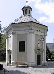
The district's name comes from the Brigitta Chapel, built between 1645 and 1651.
It consists of a good tract of land secured by the regulation of the Danube
Danube
The Danube is a river in the Central Europe and the Europe's second longest river after the Volga. It is classified as an international waterway....
1870-75, and many of the major streets are named after members of the Danube Regulation Commission. Therefore, it does not contain any distinctive historical areas. Brigittenau was separated from the 2nd district in 1900. Earlier component districts were named Schottenau, Wolfsau, Taborau, and Zwischenbrücken.
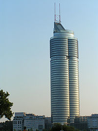
The best-known landmark is the Millennium Tower
Millennium Tower, Vienna
The Millennium Tower, located at Handelskai 94-96 in the 20th district of Brigittenau in Vienna, is the tallest building and 3rd tallest structure in Austria at 171 metres after the Donauturm. An antenna mounted on top of the tower brings the architectural height to 202 metres but does not count...
. The district also includes Adolf Hitler
Adolf Hitler
Adolf Hitler was an Austrian-born German politician and the leader of the National Socialist German Workers Party , commonly referred to as the Nazi Party). He was Chancellor of Germany from 1933 to 1945, and head of state from 1934 to 1945...
's former residence in Vienna, the Meldemannstraße dormitory
Meldemannstraße dormitory
The men's dormitory on Meldemannstraße 27 in Brigittenau district, Vienna, Austria was a public dormitory for men from 1905 to 2003. It is a subject of public interest primarily because it was the residence of Adolf Hitler, the later dictator of Nazi Germany, from 1910 to 1913.- The dormitory in...
.
Location
The Brigittenau District is located on the north end of an old, wide island between the Danube Canal and DanubeDanube
The Danube is a river in the Central Europe and the Europe's second longest river after the Volga. It is classified as an international waterway....
in the northeast of Vienna's city center area. The district is northwest of the thin Donauinsel
Donauinsel
The Donauinsel is a long, narrow island, in central Vienna, Austria, between the Danube river and the parallel excavated channel Neue Donau . The island is 21.1 km in length, but is only 70–210 metres broad...
("Danube Island"), across on the northeast side of the Danube. The average height of the district area is 162.4 m above sea level.[2] The area was originally called "Unterer Werd" (Werd = island). Through the regulation of the Danube, the character of the district area significantly changed. The floodplain and Donaualtarme stocks gradually disappeared. The Brigittenau District covers an area of 5.67 square kilometres (2.2 sq mi), or 1.4% of the Vienna area. This puts Brigittenau in the lower middle of the Vienna municipal districts. Due to its location, about 21% of the area is on water, the second highest value in Vienna. While green space is below average, the proportion in the traffic areas is among the highest. In the south, the Brigittenau District borders the 2nd District, Leopoldstadt
Leopoldstadt
Leopoldstadt is the 2nd municipal District of Vienna . There are inhabitants over . It is situated in the heart of the city and, together with Brigittenau , forms a large island surrounded by the Danube Canal and, to the north, the Danube. It is named after Leopold I, Holy Roman Emperor...
.
Geology
The Brigittenau District lies on the western edge of the Vienna Basin. The deeper background of the Vienna Basin is the Brigittenau from flysch rocks. With the demolition of the Vienna Basin, this is a layer on top Brigittenauer only 200 metres (656.2 ft) in height, however, in intermediate bridges 2000 metres (6,561.7 ft) in depth. During the Mittelmiozän (Badener layer) broke the pool and it has been in power less freshwater sediments (sands and conglomerates) deposited. From the East stored Tonmergel the sea, sand and algae, whose thickness increases to the east. In Sarmat (Upper) was created by the performance of the oceans is brackish fauna and the deposition of Tonmergel. Again, this shift is in their power from west to east. On Brigittenauer Spitz lies 10 metres (32.8 ft) below the surface, at intermediate bridges in 360 metres (1,181.1 ft) deep. The increasingly freshwater lake formed during the re-Tegel Pannon deposits. The territory of Brigittenau is covered with Quaternary deposits, with thickness from 10 metre. The bottom layers consist mostly of gravel with sand and Kieslagen. In the area between Heiligenstädter bridge, Franz-Josefs-Bahnhof, Augarten and the freight station, the earth rests on clays, fine sand and loamy lößähnliche deposits. The gravel deposits derived from the erosion processes of the ice ages (in the PleistocenePleistocene
The Pleistocene is the epoch from 2,588,000 to 11,700 years BP that spans the world's recent period of repeated glaciations. The name pleistocene is derived from the Greek and ....
), with large quantities of gravel lands. The Danube in this section deposits wide terraces, where the Brigittenau in the "zone of recent meanderings" is the postglacial part of the terrace of the Prater
Prater
The Wiener Prater is a large public park in Vienna's 2nd district . The amusement park, often simply called "Prater", stands in one corner of the Wiener Prater and includes the .-Name:...
. Alternating floods and the ever-new transfer of the Danube, with formation of new gravel banks, led to a low deposition rate of only 10 to 15 meters. Above the gravel deposits are gray and brown alluvial soils.[3]
Land use
The developed area of Brigittenau comprises 38.7% (Vienna city-wide 33.32%) of the district area. The proportion of housing in the developed area amounts to 64.2%, plus 21.2% for operations, and 10.7% dedicated for facilities in the cultural, religious, sports or the public sector. Greenspace in Brigittenau takes in only 7.9%, for which Brigittenau lies in the lower third of the Vienna municipal districts. About 66% of green space is in parks, 22.3% in sport and leisure areas, with the remainder in small gardens and meadows. Due to the large shares of the area for the Danube Canal and Danube, waters take 20.9% of the total district territory. This is the second highest value of a district. The proportion of trafficked area in the district, with 32.9%, is the fourth highest value in Vienna.| Builtspace | Greenspace | Water | Transport areas | |||||||
| 219.17 | 43 | 118.26 | 186.24 | |||||||
|---|---|---|---|---|---|---|---|---|---|---|
| Residences | Oper- ations |
Public Facilities | Farms | Parks | Forests | Meadows | Small gardens | Rec. Recreation Recreation is an activity of leisure, leisure being discretionary time. The "need to do something for recreation" is an essential element of human biology and psychology. Recreational activities are often done for enjoyment, amusement, or pleasure and are considered to be "fun"... areas |
||
| 140.65 | 46.4 | 23.43 | 0 | 28.38 | 0 | 3.73 | 1.31 | 9.58 | ||
Neighboring districts
Brigittenau to the west is bordered by the Danube Canal, which separates it from the district of DöblingDöbling
Döbling is the 19th District in the city of Vienna, Austria . It is located on the north end from the central districts, north of the districts Alsergrund and Währing...
, in the northwest, and from Alsergrund, in the southwest. The district boundary runs along the right bank, making the surface water of the Danube canal count towards Brigittenau. In the east, the left bank of the Danube River (at Danube Island) is the border with district Floridsdorf
Floridsdorf
Floridsdorf is the 21st district of Vienna, Austria .Floridsdorf is located in the northern part of Vienna.The District Office and the centre of Floridsdorf are located round Am Spitz, at the junction of Prager Straße and Brünner Straße .Since 2004, Floridsdorf has had its own tower: the...
. Also here, the water area of the Danube counts toward Brigittenau. Southeast of the Brigittenauer Bridge, take the district boundaries of Brigittenau, Floridsdorf, the Danube, and Leopoldstadt together, with the southern boundary forming the northern border of Leopoldstadt. This border runs across the Danube, and then along the line Innstraße - Dresdner Straße - Nordbahnstraße - Taborstraße - Northwest Bahnstrasse - Rauscherstraße (wall of Augartens) - Wasnergasse (wall of Augartens) and Perinetgasse on the Danube Canal.
District parts
Brigittenau consists of two formerly separate communities, as the eponymous Brigittenau and Zwischenbrücken. Zwischenbrücken, however, is divided between LeopoldstadtLeopoldstadt
Leopoldstadt is the 2nd municipal District of Vienna . There are inhabitants over . It is situated in the heart of the city and, together with Brigittenau , forms a large island surrounded by the Danube Canal and, to the north, the Danube. It is named after Leopold I, Holy Roman Emperor...
and Brigittenau. The southern part of Zwischenbrücken is now in Leopoldstadt; the eastern part fell victim to the Danube regulation.
Brigittenau received nearly 463.84 hectares (1,146.2 acre) of the 567.67 hectares (1,402.7 acre) municipal district of the like-named Katastralgemeinde
Katastralgemeinde
A Katastralgemeinde , a German word , is a cadastral subdivision of municipalities in the nations of Austria, Croatia, the Czech Republic, Slovakia, the Italian provinces of South Tyrol, Trentino, Gorizia, Trieste, and in Slovenia.A cadastral community records property ownership in a cadastre,...
.
Only the water area of the Danube belongs to three other Katastralgemeinden; the largest part lies in the Floridsdorf District. There are 31 hectares (76.6 acre) in Donaufeld, 42.83 hectares (105.8 acre) in Floridsdorf and 30 hectares (74.1 acre) in Schwarzen Lackenau.
A further breakdown of the district area is in the census-districts of official statistics, in which the municipality counts are combined. The eight census-districts (Zählbezirke) in Brigittenau are: Kapaunplatz, Zwischenbrücken, Brigittaplatz, Lorenz Müller-Gasse, Wallensteinstraße, Wextraße, Höchstädtplatz und Nordwestbahnhof.
History
The first known settlers of this area were Babenberg, in the 11th century. In 1096, the area had been extended by Leopold III to the monastery he founded St. Mary Nivenburg (today Klosterneuburg Abbey). The owners were often changed because the country is often away from the Abbey, has been sold and leased.In the 13th Century, the area was first documented in a chronicle. The Viennese denoted the area as "Werd" (Island). The first settlers in this area were fishermen, hunters and lumbermen. Later, too, settled for gardeners and farmers.
1463/64: The Shock Bridge (today's Sweden Bridge, Schwedenbrücke) was built. This was the first permanent bridge over the still unregulated inner-city branch of the Danube.
1529: The first Turkish siege of Vienna - There was heavy fighting in the area of the Danube islands.
1536 to 1540: were in those plots away Vienna, the Turks during the siege had lost their homes.
1618-1648: Thirty Years War: On 9 April 1645, the Swedish army under Lennart Torstenson won the Wolf's Lair (Wolfsschanze). Imperial troops conquered back the area in a four-day battle, so the Brigittasage - note also the history of Brigittakapelle.
1670: The first written mention is made of "Brigittenau". The previous names were: "Im Werd", "Schottenau" and "Wolfsau".
1683: Second Turkish siege of Vienna - The Brigittakapelle is in heavy fighting in the Wolf's Lair and the current peace bridge destroyed.
1695: The Brigittakapelle was rebuilt.
1732: The court- and the Landjägeramt Fasanerie are established. 1796: Near the Tabor bridge, the Johann Nepomuk
John of Nepomuk
John of Nepomuk is a national saint of the Czech Republic, who was drowned in the Vltava river at the behest of Wenceslaus, King of the Romans and King of Bohemia. Later accounts state that he was the confessor of the queen of Bohemia and refused to divulge the secrets of the confessional...
chapel is built.
1810: In Brigittenau, the first hand-craft businesses settled, such as a Kunstblecherei, a steam sawmill and a fire-syringe factory.
1828: The Colosseum, an entertainment facility, was built.
1830: There was a devastating ice floe and a great flood from the Danube.
1834: Construction of the "Universum" (today's Universe Street), another venue.
1838: The Emperor Ferdinand-Nordbahn opened, in 1837 as the first steam train of the Empire of Austria (including Hungary at that time) on the leg Floridsdorf - Deutsch Wagram, now crossed the Danube to the North Station at Praterstern.
1840: The first rail-bound train horses drove along what is now the Jägerstraße of old Tabor to the "Colosseum".
1846: The clearing of the remaining Auwaldes, and the creation of nurseries (Vorgartenstraße) in the north of the district.
1848: Robert Blum
Robert Blum
thumb|Painting by August Hunger of Robert Blum between 1845 and 1848Robert Blum was a German democratic politician, publicist, poet, publisher, revolutionist and member of the National Assembly of 1848. In his fight for a strong, unified Germany he opposed ethnocentrism and it was his strong...
execution in "Brigittawaldl" by imperial military. The German deputies had come to the Frankfurt National Assembly, in Vienna, to support the democrats against the reactionaries.
1850: The Brigittenau area, between the Danube Canal and Danube, was incorporated as Leopoldstadt in the city of Vienna. It was the 2nd District of Vienna.
1862: A major flood occurs, the final impetus to the Danube regulation (to begin in 1870).
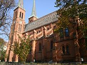
1867: Construction starts for the Brigittakirche church.
1870 Construction begins on major Danube regulation and the construction of the Northwest station at the site of the former "Universums", near the present Tabor.
1871: The Northwest Railway Bridge and the Brigittabrücke (now Peace Bridge) were built.
1873: North rail bridge (Nordbahnbrücke) is built; construction of the Northwest station ended.
1874: Inauguration of Brigittakirche (church) and the Kaiser-Franz-Joseph Bridge over the new (since 1875 leading water) stream bed of the Danube (today Floridsdorfer Bridge).
1875: The New Danube
New Danube
The New Danube is a side channel on the eastern side of the Danube in Vienna, Austria. It was created to provide flood relief by containing excess water. The Donauinsel , made out of the removed material, separates the new waterway from the main channel of the river...
bed is ready, and there were major gains in territory by the Danube regulation.
1883-1884: Construction of the Kaiser-Franz-Joseph-Government Jubilee Bridge (now Heiligenstädter Bridge) across the Danube Canal.
1886: Opening of the Dampftramway for Vienna-Stammersdorf. The route into this today in the 21st District, led through Jägerstraße, Stromstraße und Marchfeldstraße and over the Kaiser-Franz-Josephs-Brücke.
1897 The first electric tram drove in Vienna. The "Transversallinie" (today, line 5) joined the Vienna head stations of North, Northwest, Franz Joseph and Western Railway and led, of 2 Coming district, along the Augartens (Rauscherstraße) and Wallenstein Street, then on the Brigittabrücke (today's Peace Bridge, Friedensbrücke) in the 9th District.
With the diversion of the Danube zentrumsnächsten arm (of the Danube Canal) from the main stream since 1873, had a floating barrier ( "lock ship") when needed in the water inflow is limited. 1894-98 Otto Wagner built instead Nußdorfer Defense (Schemerlbrücke) and also a chamber lock for shipping.
1900: On 24 March 1900, at the request Brigittenauer politicians to separate Brigittenau from Leopoldstadt
Leopoldstadt
Leopoldstadt is the 2nd municipal District of Vienna . There are inhabitants over . It is situated in the heart of the city and, together with Brigittenau , forms a large island surrounded by the Danube Canal and, to the north, the Danube. It is named after Leopold I, Holy Roman Emperor...
. Brigittenau, by the council, was declared the 20th Viennese district (until 1904, the highest district number).
1906: The Amtshaus on the Brigittaplatz opened.
1906: On 7 July, Anton Karas
Anton Karas
Anton Karas was a Viennese zither player, best known for his soundtrack to Carol Reed's The Third Man.-Early life:...
was born in the house at Leystraße 46 (In 1948 he directed by Carol Reed, involved for the music for the film The Third Man
The Third Man
The Third Man is a 1949 British film noir, directed by Carol Reed and starring Joseph Cotten, Alida Valli, Orson Welles, and Trevor Howard. Many critics rank it as a masterpiece, particularly remembered for its atmospheric cinematography, performances, and unique musical score...
(Der dritte Mann) and with his Harry Lime Theme from 1949 becomes known worldwide.)
1907: the operation of the Betriebsbahnhof (in Vienna also known as Remise) Wexstraße tram for the then Lines 3, 34 und V (sprich: vau).
1910: The Dampftramway to Stammersdorf is replaced by electric tram (Straßenbahn) Line 31.
The Stammer Dampftramway after village is by the electric tram (line 31) is replaced.
1912, start of construction for the conversion of Emperor Franz Joseph Bridge. The new Floridsdorfer Bridge, only after the First World War, opened in 1922.
1913: In the hall of the Northwest Station, at a rally of the Sozialdemokratische Reichsratsabgeordnete, Franz Schuhmeier is murdered by Paul Kunschak (brother of the Christian politician Leopold Kunschak).
1914: creation of Sascha-Film, which started in Brigittenau (Treustraße 76), produced by Alexander Graf Kolowrat-Krakowsky.
1924: Opening of the community residential complex "Winarsky-Court" (Winarsky-Hof); in their planning in 1921, involved known architects like Adolf Loos and Margarete Schuette-Lihotzky.
1924-1926: Replacement of old Brigittabrücke on the Danube Canal through the new Peace Bridge (Friedensbrücke).
1926: Establishment of the accident-hospital (Unfallkrankenhaus) in Webergasse, under the direction of Dr. Lorenz Böhler
Lorenz Böhler
Lorenz Böhler was an Austrian physician and famous surgeon.Böhler is most notable as one of the—or even the—creator of modern accident surgery. He was the head of the AUVA-Hospital in Vienna, Brigittenau, that was later named after him: Lorenz-Böhler-Unfallkrankenhaus...
.
1929: Huge ice floe on the Danube.
1932: The large municipal residential complex at the Friedrich-Engels-Platz (at Floridsdorfer Bridge) is completed (begun 1930).
From 1938: Terror against Jewish Viennese, with expulsion and mass murder. The school Karajangasse becomes the first concentration camp (Sammellager).
1938: In the hall of the Northwest Station (Nordwestbahnhof), the Nazi Degenerate Art exhibition (NS-Ausstellung Entartete Kunst).
1943: Construction of the Flak towers (Flaktürme) in Augarten (2nd district, just on the border of Brigittenau).
16 July 1944: First American bombing at Vienna causes severe damage to Brigittenau.
April 1945: Heavy bomb damage to Bezirksamt, Brigittakirche, Leyschule and many other buildings, total destruction of the All Saints Church (Allerheiligenkirche). Blowing up the Floridsdorfer Bridge peeling by German troops. Brigittenau was occupied by Russian troops.
1946: On 19 May, the Floridsdorfer Bridge reopened as Malinowsky Bridge (Malinowskybrücke, in honor of Soviet Marshal Rodion Yakovlevich Malinowski, the commander of the 2nd Ukrainian Front, at Vienna). Since 1956, the bridge is again called Floridsdorfer Bridge. Reconstruction the Döblinger and the Peace Bridge (Friedensbrücke).
1952: Removal of the destroyed Northwest station hall.
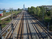
1962: New Vienna fast-rail with the stop Traisengasse, on the north track through Brigittenau. (Today another stop: Handelskai).
1964: Opening of the Belt Bridge (Gürtelbrücke) over the Danube Canal.
1972: Opening of the new Lorenz-Boehler-accident hospital in Donaueschingenstraße.
1977: Opening the new building of the General Accident Insurance.
1978: Opening of the newly established Floridsdorfer Bridge, next to the old, dilapidated, which is then removed.
1979: Construction of TGM (Technological Gewerbemuseum) in the Wexstrasse.
1982: Opening of the 7th Vienna Danube bridge, the Brigittenauer Bridge, between North Bridge and the Empire Bridge.
1996: Opening of the subway line U6, the belt by Brigittenau after Floridsdorf. At the district field stations Jägerstraße, Dresdner Street and Handelskai.
1996: (also) The border changed at Döbling
Döbling
Döbling is the 19th District in the city of Vienna, Austria . It is located on the north end from the central districts, north of the districts Alsergrund and Währing...
, in the field of Nußdorfer lands on the Danube Canal.[5] By this, Brigittenau lost beyond the shore area, west of the Danube Canal to Döbling, and received in return, the northern tip of Brigittenauer, which until then had belonged to Döbling.
1999: Opening of the Millennium Tower, the tallest building in Vienna.
Population
Data from Statistik Austria http://www.statistik.at/blickgem/vz1/g92001.pdf |
Population development
In 1869, the present area comprising Brigittenau, as part of the then Leopoldstadt, had only 15,922 inhabitants. After the completion of the Danube regulation in 1875, the number of inhabitants grew strongly by the addition of new mining areas from the 1880s. In the 1880s and 1890s, Brigittenau was the fastest growing sub-district of Vienna, and in 1910, the district reached a peak of 101,326 residents. After the First World War, the population of Brigittenau gradually, in particular the increased housing demand played a role. Until the '80s, the population and marked 1991, a low of 71,876 District residents. Then the influx of population began to grow again, with the population in early 2007 as 82,121 people. Brigittenau is one of the most densely populated districts of Vienna.Population structure
The age structure of the district population in 2005 was slightly younger than the average for Vienna city-wide. The number of children under 15 years was 14.9%, slightly higher than the total average for Vienna (14.6%). The proportion of the population from 15 to 59 years was 64.7% (Vienna: 63.4%), above average, while the proportion of people aged 60 or more years, with 20.5% (Vienna: 22.0%) was lower. The gender distribution in the district area, in 2001, was 48.6% men and 51.4% women. The number of married people had a share of 41.0%, compared with city-wide 41.2%, slightly below the average of Vienna.Origin and language
The proportion of foreign district residents in 2005 was 26.2% for Brigittenau (Vienna city-wide: 18.7%). This was the third highest value of a district of Vienna. As in the entire state, the foreign population growth, to 2001, the figure was at 24.1%. The highest proportion of foreigners, in 2005, was represented by approximately 7.0% share of the district population as nationals from Serbia and Montenegro. Another 5.4% were Turkish, Polish 1.6%, or 1.4% each for Bosnian and Croatian citizens. In 2001, a total of 31.0% of the district population was born in Austria. Nearly 9.4% expressed as a language Serbian, Turkish 9.3% and 3.3% Croatian.Religious preferences
Due to the high proportion of foreigners, Brigittenau with 42.4%, was one of the lowest populations of people with Roman Catholic faith (Vienna city-wide: 49.2%). There are four district Roman Catholic parishes, which includes 20 city Deanery. The proportion of people with Islamic faith, at 14.1%, is the second highest value in Vienna. Also, the percentage of Eastern Orthodox believers was 8.4%, much higher than the average. The proportion of Protestant residents stood at 3.1% below the average. Nearly 24.7% of the district population, in 2001, were not included in a religious community. Another 7.4% had no religion or another preference stated.Politics
| District Directors from 1945 | |
|---|---|
| Josef Wolf (unbekannt) | 4/1945-7/1945 |
| Karl Michael (SPÖ SPO - Technology :SPO: Microsoft SharePoint Online, Microsoft Cloud Computing, Office 365. See Microsoft Online Services-Economics:* Secondary Public Offering, an equity capital market instrument... ) |
1945-1954 |
| Franz Koblizka (SPÖ SPO - Technology :SPO: Microsoft SharePoint Online, Microsoft Cloud Computing, Office 365. See Microsoft Online Services-Economics:* Secondary Public Offering, an equity capital market instrument... ) |
1954-1969 |
| Johann Stroh (SPÖ SPO - Technology :SPO: Microsoft SharePoint Online, Microsoft Cloud Computing, Office 365. See Microsoft Online Services-Economics:* Secondary Public Offering, an equity capital market instrument... ) |
1969-1978 |
| Anton Deistler (SPÖ SPO - Technology :SPO: Microsoft SharePoint Online, Microsoft Cloud Computing, Office 365. See Microsoft Online Services-Economics:* Secondary Public Offering, an equity capital market instrument... ) |
1978-1987 |
| Karl Lacina (SPÖ SPO - Technology :SPO: Microsoft SharePoint Online, Microsoft Cloud Computing, Office 365. See Microsoft Online Services-Economics:* Secondary Public Offering, an equity capital market instrument... ) |
1987-2008 |
| Hannes Derfler (SPÖ SPO - Technology :SPO: Microsoft SharePoint Online, Microsoft Cloud Computing, Office 365. See Microsoft Online Services-Economics:* Secondary Public Offering, an equity capital market instrument... ) |
2008– |
The SPÖ
SPO
- Technology :SPO: Microsoft SharePoint Online, Microsoft Cloud Computing, Office 365. See Microsoft Online Services-Economics:* Secondary Public Offering, an equity capital market instrument...
has always been the strongest party in Brigittenau. In 1996, the SPÖ's absolute majority was broken by heavy losses to the FPÖ
FPO
FPO may refer to:*Fleet Post Office, a "city" designation in military mail *Field post office, a term for military post offices in military mail systems *For position only, a designation for placeholder graphics...
. With 31.1% of the vote, the FPÖ reached their third highest result in Vienna. In the 2001 election, the SPÖ reclaimed the absolute majority, due to a general FPÖ downturn. This downturn continued in 2005, when the FPÖ reached only 16.6% of the vote, a 15% decline since 1996.
Brigittenau has however been a battle district between the fronts of FPÖ and SPÖ.
The next time things moved was in 2010 when the SPÖ was decreased 8.5% and lost their absolute majority reaching 47.8% now
and the FPÖ increased 11.3% up to now 27.9%.
The Green Party reached 12.0% of the votes and stagnated.
The ÖVP traditionally only plays a small role in Brigittenau and even fall down to 8.5% (the first time in history they were below the 10% in Brigittenau) only being 4th strongest party in the 2010 elections.
And the new found BZÖ reached 1.0% in the 2010 elections.
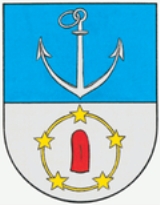
Crest (coat of arms)
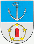
John of Nepomuk
John of Nepomuk is a national saint of the Czech Republic, who was drowned in the Vltava river at the behest of Wenceslaus, King of the Romans and King of Bohemia. Later accounts state that he was the confessor of the queen of Bohemia and refused to divulge the secrets of the confessional...
, the patron of the bridges and also stands for that originally laid zone between the Danube and the Kaiserwasser.
Sightseeing
- Allerheiligenkirche - All Saints Church
- Brigittakapelle - Brigitta Chapel
- Brigittakirche - Brigitta Church
- Kirche Zum Göttlichen Erlöser
- Sankt Johann Kapistran-Kirche
- Kirche Muttergottes im Augarten
Museum
The district controls a single museum. The District Museum of Brigittenau dedicates itself the district story that is represented by plans, pictures, views and models. Thereto the story of the Danube, as well as special displays, are presented. Focal points of the museum are, among other things, the business story and industry story, the transport and communications, everyday life and company life, and the mathematician Carl Friedrich Gauß.Traffic
Over 40 percent of the Brigittenau land area is in traffic zones. The green area share amounts to, on the other hand, only about ten percent.Above all the container-terminals Nordwestbahnhof and Knoten Nußdorf are most noticeable, due to the enormous area requirement. The traffic load is very high because the most important traffic arteries that cross the Danube pass through the district. The next bridge over the Danube upstream is 50 km (30 mi) away in Tulln
Tulln an der Donau
Tulln an der Donau is a town in the Austrian state of Lower Austria, and the seat of the Tulln district. Because of its abundance of parks and other green spaces, Tulln is often referred to as Blumenstadt, meaning city of flowers...
. Moreover 86 percent of all Brigittenauers employed do not work in the district.
People
- Lorenz BöhlerLorenz BöhlerLorenz Böhler was an Austrian physician and famous surgeon.Böhler is most notable as one of the—or even the—creator of modern accident surgery. He was the head of the AUVA-Hospital in Vienna, Brigittenau, that was later named after him: Lorenz-Böhler-Unfallkrankenhaus...
- Lotte HassLotte HassCharlotte Hildegard Hass is the second wife of the Austrian naturalist and diving pioneer Hans Hass and worked as an underwater model and actress in several of his films...
- Herbert RosenkranzHerbert RosenkranzHerbert Rosenkranz was a Jewish historian.-Life:Herbert Rosenkranz grew up in the Viennese district of Brigittenau. His Jewish parents, Michael and Mircia, , and his grandparents had immigrated from Eastern Europe. The family emigrated to Riga after the „Anschluss" of Austria to Hitler-Germany...
- Kurt RosenkranzKurt Rosenkranz- Life :Kurt Rosenkranz grew up in the Viennese district of Brigittenau. His Jewish parents and grandparents had emigrated from Eastern Europe to Vienna. At the age of 9 he became a member of the boys' choir at the temple in Kaschlgasse....