
Bridal Veil Falls Provincial Park
Encyclopedia
Bridal Veil Falls Provincial Park is located on the Trans-Canada Highway
just east of Rosedale
, British Columbia
, Canada
, part of the City of Chilliwack
. The community of Bridal Falls
is located adjacent to the falls and park was well as the interchange between the Trans-Canada and BC Highway 9
and has a variety of highway-based tourism services.
It is located near the 38th highest waterfall
in British Columbia
(Bridal Veil Falls) and is commonly stated incorrectly as the 4th tallest in Canada
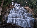
. The falls drop 122 metres (400 feet) over a wide rock face, creating a "veil-like" effect, however, only the bottom 200–250 feet can clearly be viewed from the base, due to significant foreshortening due to the viewing-points' location at the base of very steep mountainside. It is located at the south end of the land set aside as provincial Park. Its source is from Mount Archibald and flows into Bridal Creek where it travels to Cheam Lake Wetlands Regional Park and finally to the Fraser River
.
During drier summer months, the volume of the water decreases significantly, reducing the visual effect of the waterfall.
Bridal Veil Falls tend to freeze during cold winters and creates a wall of unstable ice. Although it is nice to look at, the base of the falls becomes an extremely hazardous area and the park remains closed during the winter season.
Bridal Veil Falls was named in the 19th century by the village of Popkum. In the early 20th century, the village utilized the waterfall with a hydro-electric generator to power the chalet
and heated swimming pool in the village. Only the concrete foundation of the generator can be found today.
Trans-Canada Highway
The Trans-Canada Highway is a federal-provincial highway system that joins the ten provinces of Canada. It is, along with the Trans-Siberian Highway and Australia's Highway 1, one of the world's longest national highways, with the main route spanning 8,030 km...
just east of Rosedale
Rosedale, British Columbia
Rosedale is a farming-based community located in Chilliwack, British Columbia. It serves as a base for many tourists, both in summer and winter. The hills and valleys of British Columbia are popular skiing, snowboarding and dogsledding locations...
, British Columbia
British Columbia
British Columbia is the westernmost of Canada's provinces and is known for its natural beauty, as reflected in its Latin motto, Splendor sine occasu . Its name was chosen by Queen Victoria in 1858...
, Canada
Canada
Canada is a North American country consisting of ten provinces and three territories. Located in the northern part of the continent, it extends from the Atlantic Ocean in the east to the Pacific Ocean in the west, and northward into the Arctic Ocean...
, part of the City of Chilliwack
Chilliwack, British Columbia
Chilliwack is a Canadian city in the Province of British Columbia. It is a predominantly agricultural community with an estimated population of 80,000 people. Chilliwack is the second largest city in the Fraser Valley Regional District after Abbotsford. The city is surrounded by mountains and...
. The community of Bridal Falls
Bridal Falls, British Columbia
Bridal Falls is a community in the Fraser Valley of British Columbia, located east of Rosedale and immediately adjacent to the on-ramps for the Agassiz-Rosedale Bridge, which connects the Trans-Canada Highway at Bridal Falls to Agassiz, on BC Highway 7. Bridal Falls is mostly a highway services...
is located adjacent to the falls and park was well as the interchange between the Trans-Canada and BC Highway 9
British Columbia provincial highway 9
Highway 9, the Agassiz-Rosedale Highway, is a north-south route in the eastern part of the Fraser Valley. It acts as the last connection between Highways 1 and 7 eastbound before Hope, and is the main access to the resort village of Harrison Hot Springs...
and has a variety of highway-based tourism services.
It is located near the 38th highest waterfall
Waterfall
A waterfall is a place where flowing water rapidly drops in elevation as it flows over a steep region or a cliff.-Formation:Waterfalls are commonly formed when a river is young. At these times the channel is often narrow and deep. When the river courses over resistant bedrock, erosion happens...
in British Columbia
British Columbia
British Columbia is the westernmost of Canada's provinces and is known for its natural beauty, as reflected in its Latin motto, Splendor sine occasu . Its name was chosen by Queen Victoria in 1858...
(Bridal Veil Falls) and is commonly stated incorrectly as the 4th tallest in Canada
Canada
Canada is a North American country consisting of ten provinces and three territories. Located in the northern part of the continent, it extends from the Atlantic Ocean in the east to the Pacific Ocean in the west, and northward into the Arctic Ocean...
. The falls drop 122 metres (400 feet) over a wide rock face, creating a "veil-like" effect, however, only the bottom 200–250 feet can clearly be viewed from the base, due to significant foreshortening due to the viewing-points' location at the base of very steep mountainside. It is located at the south end of the land set aside as provincial Park. Its source is from Mount Archibald and flows into Bridal Creek where it travels to Cheam Lake Wetlands Regional Park and finally to the Fraser River
Fraser River
The Fraser River is the longest river within British Columbia, Canada, rising at Fraser Pass near Mount Robson in the Rocky Mountains and flowing for , into the Strait of Georgia at the city of Vancouver. It is the tenth longest river in Canada...
.
During drier summer months, the volume of the water decreases significantly, reducing the visual effect of the waterfall.
Bridal Veil Falls tend to freeze during cold winters and creates a wall of unstable ice. Although it is nice to look at, the base of the falls becomes an extremely hazardous area and the park remains closed during the winter season.
Bridal Veil Falls was named in the 19th century by the village of Popkum. In the early 20th century, the village utilized the waterfall with a hydro-electric generator to power the chalet
Chalet
A chalet , also called Swiss chalet, is a type of building or house, native to the Alpine region, made of wood, with a heavy, gently sloping roof with wide, well-supported eaves set at right angles to the front of the house.-Definition and origin:...
and heated swimming pool in the village. Only the concrete foundation of the generator can be found today.