
Bramerton
Encyclopedia
Bramerton is a village in South Norfolk
4¾ miles (7½ km) south-east of Norwich
, just north of the main A146
Norwich-Lowestoft
road and on the south bank of the River Yare
. In the 2001 census
it contained 158 households and a population of 350.
Bramerton is also the home to Bramerton Health Care Clinic offering homeopathy
, herbal
supplements and dietary advice.
Bramerton is part of South Norfolk
District
, but parts of the village lying adjacent to and in the vicinity of the river fall into the executive area of the Broads Authority
.
See St Peters Bramerton page on the Norfolk Churches website
 There has been an inn
on the site since before 1700. In 1828 the area and the nearby river were painted by Joseph Stannard
, prominent in the Norwich School; entitled Boats on the Yare near Bramerton, Norfolk, his painting is now in the Fitzwilliam Museum
in Cambridge
. In Victorian times the inn possessed tea room
s and gardens popular with river-borne day-tripper
s from Norwich. The Woods End is still a popular spot for the mooring of pleasure craft and is also one of the few places on the Norfolk Broads where water skiing
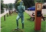
is allowed. Outside the pub is a statue of Billy Bluelight
(William Cullum), who in the 1920s-30s used to challenge boat trippers to a race along the river bank. He is famed for his claim... "My name is Billy Bluelight, my age is 45, I hope to get to Carrow Bridge before the boat arrive." He is said to have remained '45' for many years.
Just to the east lies Bramerton Common, a public staithe and green. The rocks coming to the surface in the woods adjacent to the common have given their name to an inter-glacial stage in Britain's pre-history. (See Geology below).
Bramerton Woods End
See Woods End Inn page of www.norfolkpubs.co.uk for historical details.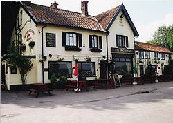
club was founded in 1965, moving to its current location near the village hall in 1972. The village hall itself was erected by voluntary labour in 1988 after having been rescued from its previous existence as a Surlingham bungalow. The village hall is now the venue for a range of activities including a play group, Sunbeams, Brownies
and yoga
. Adjacent to the Bowls club is a children's playground with swings, climbing frame and slide. At Grange Farm Barns in the centre of the village is a Caravan Club
certified location.
via Kirby Bedon
and to the neighbouring villages of Surlingham
and Rockland St. Mary—timetable
National Cycle Route 1 passes Woods End on its route from Norwich via Trowse
and Whitlingham
and out to Loddon
via Surlingham.
The Wherryman's Way a Long distance footpath passes close by at Woods End.
, adjacent to the Common at Woods End, have resulted in the name of the village being given to an early Pleistocene
glacial stage in the geological pre-history of the British Isles. The Bramertonian Stage is distinguished by the presence of shelly, sandy deposits indicative of a temperate climate. Bramerton Pits has been noted as a Site of Special Scientific Interest
on account of the geology and has been excavated on several occasions.
South Norfolk
South Norfolk is a local government district in Norfolk, England. Its council is based in Long Stratton.-History:The district was formed on April 1, 1974, under the Local Government Act 1972, as a merger of Diss Urban District, Wymondham Urban District, Depwade Rural District, Forehoe and Henstead...
4¾ miles (7½ km) south-east of Norwich
Norwich
Norwich is a city in England. It is the regional administrative centre and county town of Norfolk. During the 11th century, Norwich was the largest city in England after London, and one of the most important places in the kingdom...
, just north of the main A146
A146 road
The A146 is a road that runs between two of East Anglia's largest population centres - Norwich in Norfolk and Lowestoft in Suffolk.The entire route has primary classification and as such has been improved over the years, although traffic levels can lead to delays.- Norwich :Before the construction...
Norwich-Lowestoft
Lowestoft
Lowestoft is a town in the English county of Suffolk. The town is on the North Sea coast and is the most easterly point of the United Kingdom. It is north-east of London, north-east of Ipswich and south-east of Norwich...
road and on the south bank of the River Yare
River Yare
The River Yare is a river in the English county of Norfolk. In its lower reaches the river connects with the navigable waterways of The Broads....
. In the 2001 census
United Kingdom Census 2001
A nationwide census, known as Census 2001, was conducted in the United Kingdom on Sunday, 29 April 2001. This was the 20th UK Census and recorded a resident population of 58,789,194....
it contained 158 households and a population of 350.
The village
Bramerton is centred along The Street, around St. Peter's Church. Opposite the church lies Church Farm, once the site of Herbert Parker Ltd agricultural and seed merchants, but now Church Farm Business Centre. Bramerton no longer has a post office (closed 1968), shop (closed 1977) or school (closed 1978) but still has a pub, the Woods End, which lies on the south bank of the River Yare to the north of the village centre, in the hamlet of Woods End. At the north end of the village is a Dawn Christadelphian Hall, first opened in 1952 and extended in the 1960s and then again in the 1980s. A secondary hall for youth activities was added in the 2000s.Bramerton is also the home to Bramerton Health Care Clinic offering homeopathy
Homeopathy
Homeopathy is a form of alternative medicine in which practitioners claim to treat patients using highly diluted preparations that are believed to cause healthy people to exhibit symptoms that are similar to those exhibited by the patient...
, herbal
Herbalism
Herbalism is a traditional medicinal or folk medicine practice based on the use of plants and plant extracts. Herbalism is also known as botanical medicine, medical herbalism, herbal medicine, herbology, herblore, and phytotherapy...
supplements and dietary advice.
Bramerton is part of South Norfolk
South Norfolk
South Norfolk is a local government district in Norfolk, England. Its council is based in Long Stratton.-History:The district was formed on April 1, 1974, under the Local Government Act 1972, as a merger of Diss Urban District, Wymondham Urban District, Depwade Rural District, Forehoe and Henstead...
District
District
Districts are a type of administrative division, in some countries managed by a local government. They vary greatly in size, spanning entire regions or counties, several municipalities, or subdivisions of municipalities.-Austria:...
, but parts of the village lying adjacent to and in the vicinity of the river fall into the executive area of the Broads Authority
Broads Authority
The Broads Authority is the agency which has statutory responsibility for the Broads in England. Originally, the Nature Conservancy Council , pressed for a special authority to manage the Broads which had been neglected for a long time. In 1978, the forerunner to the present-day Broads Authority...
.
St. Peter's Church
Parts of the church date from the 13th century. It was extensively rebuilt in 1462 and following restoration in the 19th century the interior is now almost entirely Victorian. The entrance to the churchyard is via a lych-gate built in the late 1920s by local carpenter John Shingles using oak from local trees.See St Peters Bramerton page on the Norfolk Churches website
Woods End
INN
InterNetNews is a Usenet news server package, originally released by Rich Salz in 1991, and presented at the Summer 1992 USENIX conference in San Antonio, Texas...
on the site since before 1700. In 1828 the area and the nearby river were painted by Joseph Stannard
Joseph Stannard
Joseph Stannard was an English marine and landscape painter, and etcher, a prominent member of the Norwich School of artists , which also included John Crome and John Sell Cotman.-Life:...
, prominent in the Norwich School; entitled Boats on the Yare near Bramerton, Norfolk, his painting is now in the Fitzwilliam Museum
Fitzwilliam Museum
The Fitzwilliam Museum is the art and antiquities museum of the University of Cambridge, located on Trumpington Street opposite Fitzwilliam Street in central Cambridge, England. It receives around 300,000 visitors annually. Admission is free....
in Cambridge
Cambridge
The city of Cambridge is a university town and the administrative centre of the county of Cambridgeshire, England. It lies in East Anglia about north of London. Cambridge is at the heart of the high-technology centre known as Silicon Fen – a play on Silicon Valley and the fens surrounding the...
. In Victorian times the inn possessed tea room
Tearoom (U.K. and U.S.)
A tearoom is a small room or restaurant where beverages and light meals are served, having a sedate or subdued atmosphere. The term may also refer to a room dedicated to the serving of tea in a private house....
s and gardens popular with river-borne day-tripper
Day-tripper
A day-tripper is a person who visits a tourist destination or visitor attraction from his/her home and returns home on the same day.- Definition :In other words, this excursion does not involve a night away from home such as experienced on a holiday...
s from Norwich. The Woods End is still a popular spot for the mooring of pleasure craft and is also one of the few places on the Norfolk Broads where water skiing
Water skiing
thumb|right|A slalom skier making a turn on a slalom waterski.Waterskiing is a sport where an individual is pulled behind a boat or a cable ski installation on a body of water, skimming the surface.-History:...
is allowed. Outside the pub is a statue of Billy Bluelight
Billy Bluelight
Billy Bluelight pseudonym of William Cullum. . A much loved legendary figure in Norwich and well known for his races against steam pleasure boats in the 1920/30s along the River Wensum and River Yare....
(William Cullum), who in the 1920s-30s used to challenge boat trippers to a race along the river bank. He is famed for his claim... "My name is Billy Bluelight, my age is 45, I hope to get to Carrow Bridge before the boat arrive." He is said to have remained '45' for many years.
Just to the east lies Bramerton Common, a public staithe and green. The rocks coming to the surface in the woods adjacent to the common have given their name to an inter-glacial stage in Britain's pre-history. (See Geology below).
Bramerton Woods End
See Woods End Inn page of www.norfolkpubs.co.uk for historical details.
Sports and recreation
Bramerton and District BowlsBowls
Bowls is a sport in which the objective is to roll slightly asymmetric balls so that they stop close to a smaller "jack" or "kitty". It is played on a pitch which may be flat or convex or uneven...
club was founded in 1965, moving to its current location near the village hall in 1972. The village hall itself was erected by voluntary labour in 1988 after having been rescued from its previous existence as a Surlingham bungalow. The village hall is now the venue for a range of activities including a play group, Sunbeams, Brownies
Brownies (Girl Guides)
A Brownie is a member of a section of some Guiding organisations for girls from their seventh birthday to their tenth birthday. Exact age limits are slightly different in each organisation.-History:...
and yoga
Yoga
Yoga is a physical, mental, and spiritual discipline, originating in ancient India. The goal of yoga, or of the person practicing yoga, is the attainment of a state of perfect spiritual insight and tranquility while meditating on Supersoul...
. Adjacent to the Bowls club is a children's playground with swings, climbing frame and slide. At Grange Farm Barns in the centre of the village is a Caravan Club
Caravan Club
The Caravan Club is an organisation representing caravanners in the United Kingdom and the Republic of Ireland. It was founded in 1907 and now represents nearly 1 million members.-History:...
certified location.
Transport links
Bramerton is served by bus route 001 operated by Anglian Coaches providing six services a day into NorwichNorwich
Norwich is a city in England. It is the regional administrative centre and county town of Norfolk. During the 11th century, Norwich was the largest city in England after London, and one of the most important places in the kingdom...
via Kirby Bedon
Kirby Bedon
Kirby Bedon is a small village in South Norfolk which lies approximately 3½ miles southeast of Norwich on the road to Bramerton. It covers an area of and had a population of 186 in 77 households as of the 2001 census....
and to the neighbouring villages of Surlingham
Surlingham
Surlingham is a village and civil parish in South Norfolk situated on the Broads. It lies approximately 6½ miles south-east of Norwich on the south bank of the River Yare between Bramerton and Rockland St Mary. In the 2001 census it contained 266 households and a population of 637...
and Rockland St. Mary—timetable
National Cycle Route 1 passes Woods End on its route from Norwich via Trowse
Trowse
Trowse, also called Trowse with Newton, is a village in South Norfolk which lies about south-east of Norwich city centre on the banks of the River Yare. It covers an area of and had a population of 479 in 233 households as of the 2001 census....
and Whitlingham
Whitlingham
Whitlingham is a small churchless parish, 3 miles east of Norwich, on the south bank of the River Yare, reached from Trowse along Whitlingham Lane.-Church:...
and out to Loddon
Loddon, Norfolk
Loddon is a small market town about southeast of Norwich on the River Chet, a tributary of the River Yare within The Broads in Norfolk, England. The name "Loddon" is thought to mean muddy river in Celtic in reference to the Chet.-Origins:...
via Surlingham.
The Wherryman's Way a Long distance footpath passes close by at Woods End.
Geology
The rock strata reaching the surface at Bramerton PitsBramerton Pits
Bramerton Pits is a Site of Special Scientific Interest north of the village of Bramerton in Norfolk on the southern banks of the River Yare , where the Norwich 'Crag' comes to the surface:...
, adjacent to the Common at Woods End, have resulted in the name of the village being given to an early Pleistocene
Pleistocene
The Pleistocene is the epoch from 2,588,000 to 11,700 years BP that spans the world's recent period of repeated glaciations. The name pleistocene is derived from the Greek and ....
glacial stage in the geological pre-history of the British Isles. The Bramertonian Stage is distinguished by the presence of shelly, sandy deposits indicative of a temperate climate. Bramerton Pits has been noted as a Site of Special Scientific Interest
Site of Special Scientific Interest
A Site of Special Scientific Interest is a conservation designation denoting a protected area in the United Kingdom. SSSIs are the basic building block of site-based nature conservation legislation and most other legal nature/geological conservation designations in Great Britain are based upon...
on account of the geology and has been excavated on several occasions.
Nearby villages
- Kirby BedonKirby BedonKirby Bedon is a small village in South Norfolk which lies approximately 3½ miles southeast of Norwich on the road to Bramerton. It covers an area of and had a population of 186 in 77 households as of the 2001 census....
– 1.5 miles (2.4 km) west - SurlinghamSurlinghamSurlingham is a village and civil parish in South Norfolk situated on the Broads. It lies approximately 6½ miles south-east of Norwich on the south bank of the River Yare between Bramerton and Rockland St Mary. In the 2001 census it contained 266 households and a population of 637...
– 1.5 miles (2.4 km) northeast - Rockland St. Mary – 1.25 miles (2 km) east
- Framingham PigotFramingham PigotFramingham Pigot is a village in South Norfolk lying about 4 miles southeast of Norwich. In the 2001 census it contained 62 households and a population of 167. It covers an area of ....
– 1.25 miles (2 km) southwest
External links
- Ordnance Survey Pathfinder (1:25000) map of Bramerton
- Images of Bramerton on Geograph
- A stroll around Bramerton and Surlingham
- EDP Walk
- The Moorings holiday cottage (including photographs of Woods End and Bramerton Common)
- Bramerton on GenukiGENUKIGENUKI is a genealogy web portal, run as a charitable trust. Its aim is "to serve as a "virtual reference library" of genealogical information that is of particular relevance to the UK & Ireland"...
- Bramerton Pits