
Rockland St. Mary
Encyclopedia
Rockland St Mary is a village in South Norfolk
South Norfolk
South Norfolk is a local government district in Norfolk, England. Its council is based in Long Stratton.-History:The district was formed on April 1, 1974, under the Local Government Act 1972, as a merger of Diss Urban District, Wymondham Urban District, Depwade Rural District, Forehoe and Henstead...
which lies about 6 miles (9½ km) southeast of Norwich
Norwich
Norwich is a city in England. It is the regional administrative centre and county town of Norfolk. During the 11th century, Norwich was the largest city in England after London, and one of the most important places in the kingdom...
between Surlingham
Surlingham
Surlingham is a village and civil parish in South Norfolk situated on the Broads. It lies approximately 6½ miles south-east of Norwich on the south bank of the River Yare between Bramerton and Rockland St Mary. In the 2001 census it contained 266 households and a population of 637...
, Bramerton
Bramerton
Bramerton is a village in South Norfolk 4¾ miles south-east of Norwich, just north of the main A146 Norwich-Lowestoft road and on the south bank of the River Yare. In the 2001 census it contained 158 households and a population of 350.-The village:...
, Claxton
Claxton, Norfolk
Claxton is a small village south-east of Norwich, and south of the River Yare, between Rockland St. Mary and Loddon in South Norfolk, England. In the 2001 census it contained 85 households and a population of 244...
and Hellington
Hellington
Hellington is a small village in the county of Norfolk, England. In the 2001 census it contained 24 households and a population of 69.It is centred around a crossroads ½ mile south of Rockland St. Mary and around 6½ miles southeast of Norwich. The road north leads to Rockland St. Mary, south...
. In the 2001 census
United Kingdom Census 2001
A nationwide census, known as Census 2001, was conducted in the United Kingdom on Sunday, 29 April 2001. This was the 20th UK Census and recorded a resident population of 58,789,194....
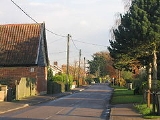
it contained 325 households and a population of 824. The Street (pictured) runs east to west through the centre of the village.
In medieval times Norwich was noted for its black-glazed roofing tiles which were made in Rockland and transported by river from the
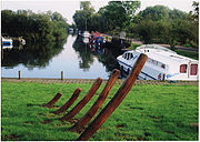
Rockland Broad
Rockland Broad lies just north of the village of Rockland St. Mary in South Norfolk, England.It comprises an area of approximately and is completely surrounded by marshland and tall reed beds. It is linked to the River Yare by two dykes: the Short Dyke and the Fleet Dyke.From the village of...
which is itself linked to the River Yare
River Yare
The River Yare is a river in the English county of Norfolk. In its lower reaches the river connects with the navigable waterways of The Broads....
by two dykes: the Short Dyke and the Fleet Dyke.
World War II
World War II, or the Second World War , was a global conflict lasting from 1939 to 1945, involving most of the world's nations—including all of the great powers—eventually forming two opposing military alliances: the Allies and the Axis...
an V-2 Rocket
V-2 rocket
The V-2 rocket , technical name Aggregat-4 , was a ballistic missile that was developed at the beginning of the Second World War in Germany, specifically targeted at London and later Antwerp. The liquid-propellant rocket was the world's first long-range combat-ballistic missile and first known...
hit a field near the school. This caused several minor injuries and one major injury. A new extension was opened in September 2004 by MP Richard Bacon
Richard Bacon (politician)
Richard Michael Bacon is a British Conservative Party politician and the Member of Parliament for the South Norfolk constituency.-Early life:...
, but it was built from Suffolk bricks!.
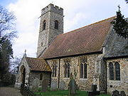
Rockland St Mary Church has a noticeably tapered tower, Tudor windows and a Victorian interior. It also contains a bronze memorial to those who both died and served in World War I
World War I
World War I , which was predominantly called the World War or the Great War from its occurrence until 1939, and the First World War or World War I thereafter, was a major war centred in Europe that began on 28 July 1914 and lasted until 11 November 1918...
(See Rockland St. Mary War Memorial for details). The churchyard supposedly contains the overgrown remains of Rockland St Margaret. Established in 1973, David Potter Ltd
has its premises in the village manufacturing easels, artists furniture and accessories.
Rockland St. Mary is served by bus route 001 operated by Anglian Bus
Anglian Bus
Anglian Bus is a large independent bus operator based in Beccles in Suffolk, England. The company operates services over a wide area in both Norfolk and Suffolk, running a fleet of around 63 buses and coaches...
providing six services a day into Norwich
Norwich
Norwich is a city in England. It is the regional administrative centre and county town of Norfolk. During the 11th century, Norwich was the largest city in England after London, and one of the most important places in the kingdom...
via Bramerton
Bramerton
Bramerton is a village in South Norfolk 4¾ miles south-east of Norwich, just north of the main A146 Norwich-Lowestoft road and on the south bank of the River Yare. In the 2001 census it contained 158 households and a population of 350.-The village:...
and Kirby Bedon
Kirby Bedon
Kirby Bedon is a small village in South Norfolk which lies approximately 3½ miles southeast of Norwich on the road to Bramerton. It covers an area of and had a population of 186 in 77 households as of the 2001 census....
. Timetable
National Cycle Route 1 passes through the east of the village on its route from Norwich via Whitlingham
Whitlingham
Whitlingham is a small churchless parish, 3 miles east of Norwich, on the south bank of the River Yare, reached from Trowse along Whitlingham Lane.-Church:...
and Surlingham, and out to Loddon
Loddon, Norfolk
Loddon is a small market town about southeast of Norwich on the River Chet, a tributary of the River Yare within The Broads in Norfolk, England. The name "Loddon" is thought to mean muddy river in Celtic in reference to the Chet.-Origins:...
and Beccles
Beccles
Beccles is a market town and civil parish in the Waveney District of the English county of Suffolk. The town is shown on the milestone as from London via the A145 Blythburgh and A12 road, northeast of London as the crow flies, southeast of Norwich, and north northeast of the county town of...
via Claxton.
Long distance footpath, Wherryman's Way lies close to the village
External links
- Ordnance Survey Pathfinder (1:25000) map of Rockland St Mary
- 4 mile walk from the EDPEastern Daily PressThe Eastern Daily Press, commonly referred to as the EDP, is a regional newspaper covering Norfolk, and northern parts of Suffolk and eastern Cambridgeshire, and is published daily in Norwich, UK....
- 6 mile walk from the EDP