

Boulder Bank
Encyclopedia
Nelson, New Zealand
Nelson is a city on the eastern shores of Tasman Bay, and is the economic and cultural centre of the Nelson-Tasman region. Established in 1841, it is the second oldest settled city in New Zealand and the oldest in the South Island....
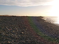
. It is a 13 kilometre long stretch of rocky
Rock (geology)
In geology, rock or stone is a naturally occurring solid aggregate of minerals and/or mineraloids.The Earth's outer solid layer, the lithosphere, is made of rock. In general rocks are of three types, namely, igneous, sedimentary, and metamorphic...
substrate which begins at the Mackay Bluff and ends at the Cut of the Nelson Harbour. Haulashore Island was once apart of the Boulder Bank, but after the Cut being made is an island, and no longer connected to the Boulder Bank. The Boulder Bank separates Tasman Bay
Tasman Bay
Tasman Bay is a large V-shaped bay at the north end of New Zealand's South Island. Located in the centre of the island's northern coast, it stretches along of coastline and is across at its widest point. It is an arm of the Tasman Sea, lying on the western approach to Cook Strait.At the bay's...
and the Nelson Haven.
Geology & Geography
The Boulder Bank is composed of granodioriteGranodiorite
Granodiorite is an intrusive igneous rock similar to granite, but containing more plagioclase than orthoclase-type feldspar. Officially, it is defined as a phaneritic igneous rock with greater than 20% quartz by volume where at least 65% of the feldspar is plagioclase. It usually contains abundant...
. The source of this rock is Mackay Bluff. It is still debated what process or processes have resulted in this odd structure. Longshore drift
Longshore drift
Longshore drift consists of the transportation of sediments along a coast at an angle to the shoreline, which is dependent on prevailing wind direction, swash and backwash. This process occurs in the littoral zone, and in or within close proximity to the surf zone...
however is the most accepted hypothesis for creation. The main objection for longshore drift is that Tasman Bay
Tasman Bay
Tasman Bay is a large V-shaped bay at the north end of New Zealand's South Island. Located in the centre of the island's northern coast, it stretches along of coastline and is across at its widest point. It is an arm of the Tasman Sea, lying on the western approach to Cook Strait.At the bay's...
does not receive enough wave action to move the large boulders in a south west direction. Studies have been conducted since 1892 to determine speed of boulder movement. Rates of the top course gravel
Gravel
Gravel is composed of unconsolidated rock fragments that have a general particle size range and include size classes from granule- to boulder-sized fragments. Gravel can be sub-categorized into granule and cobble...
movement have been estimated at 7.5 metres a year.

The Cut
The Cut was made to enable the Nelson portPort
A port is a location on a coast or shore containing one or more harbors where ships can dock and transfer people or cargo to or from land....
to allow the increasing demands of sea transport for the Tasman
Tasman, New Zealand
The Tasman Region is both a region and a district of New Zealand. It borders with the West Coast Region, Marlborough Region and the Nelson Region. It is both a region and a unitary authority, and the District Council sits at Richmond, with Community Boards serving outlying communities in Motueka...
area. Construction started in 1903 and in 1905 a 61 metre wide entrance was operational. Today the Cut is 150 metres wide and dredged every six months to maintain a depth of 10 metres.
Lighthouse
There is a small lighthouse which was erected in 1862. It is located near the port end of the Boulder Bank.Sources
- Hartstein, ND and Warren Dickinson, W (2005) Wave energy and clast transport in eastern Tasman Bay, New Zealand Earth Surface Processes and Landforms, 31:6 (703–714).
- Warren, Karen. Rolling Stones: Nelson's Boulder Bank, Place in Our History and Hearts, 320 pp, 2009, Nikau Press, Nelson, New Zealand.