Blairstown Airport
Encyclopedia
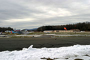
Blairstown Airport is a public-use airport
located two nautical miles (3.7 km) southwest of the central business district
of Blairstown, Warren County
, New Jersey
, United States
. It is privately owned by J.D. Air Inc. Blairstown is located in the Lehigh Valley
, 5 miles (8 km) from the Delaware Water Gap
and 65 miles (104.6 km) from New York City
. A gliding
operator, Yards Creek Soaring, is located on the field.
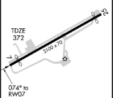
of 372 ft (113 m) and contains one runway
designated 7/25 with an asphalt
surface measuring 3,100 x 70 ft (945 x 21 m). For the 12-month period ending January 1, 2011, the airport had 19,790 general aviation
aircraft operations, an average of 54 per day. At that time there were 143 aircraft based at this airport: 55% single-engine
, 5% multi-engine, 3% helicopter
and 36% glider
.
Services available on field include 100LL fuel, major airframe service, major powerplant service, tie-downs, hangars, parking and glider operation. There are several shops and a supermarket located about 1 miles (1.6 km) north of the airport.

}
Airport
An airport is a location where aircraft such as fixed-wing aircraft, helicopters, and blimps take off and land. Aircraft may be stored or maintained at an airport...
located two nautical miles (3.7 km) southwest of the central business district
Central business district
A central business district is the commercial and often geographic heart of a city. In North America this part of a city is commonly referred to as "downtown" or "city center"...
of Blairstown, Warren County
Warren County, New Jersey
Warren County is a county located in the U.S. state of New Jersey. As of the 2010 Census, the population was 108,692. Its county seat is Belvidere...
, New Jersey
New Jersey
New Jersey is a state in the Northeastern and Middle Atlantic regions of the United States. , its population was 8,791,894. It is bordered on the north and east by the state of New York, on the southeast and south by the Atlantic Ocean, on the west by Pennsylvania and on the southwest by Delaware...
, United States
United States
The United States of America is a federal constitutional republic comprising fifty states and a federal district...
. It is privately owned by J.D. Air Inc. Blairstown is located in the Lehigh Valley
Lehigh Valley
The Lehigh Valley, known officially by the United States Census Bureau as the Allentown-Bethlehem-Easton, PA-NJ metropolitan area and referred to locally as The Valley and A-B-E, is a metropolitan region consisting of Lehigh, Northampton, Berks, and Carbon counties in eastern Pennsylvania and...
, 5 miles (8 km) from the Delaware Water Gap
Delaware Water Gap
The Delaware Water Gap is on the border of New Jersey and Pennsylvania where the Delaware River cuts through a large ridge of the Appalachian Mountains...
and 65 miles (104.6 km) from New York City
New York City
New York is the most populous city in the United States and the center of the New York Metropolitan Area, one of the most populous metropolitan areas in the world. New York exerts a significant impact upon global commerce, finance, media, art, fashion, research, technology, education, and...
. A gliding
Gliding
Gliding is a recreational activity and competitive air sport in which pilots fly unpowered aircraft known as gliders or sailplanes using naturally occurring currents of rising air in the atmosphere to remain airborne. The word soaring is also used for the sport.Gliding as a sport began in the 1920s...
operator, Yards Creek Soaring, is located on the field.
Facilities and aircraft
Blairstown Airport covers an area of 151 acres (61.1 ha) at an elevationElevation
The elevation of a geographic location is its height above a fixed reference point, most commonly a reference geoid, a mathematical model of the Earth's sea level as an equipotential gravitational surface ....
of 372 ft (113 m) and contains one runway
Runway
According to ICAO a runway is a "defined rectangular area on a land aerodrome prepared for the landing and take-off of aircraft." Runways may be a man-made surface or a natural surface .- Orientation and dimensions :Runways are named by a number between 01 and 36, which is generally one tenth...
designated 7/25 with an asphalt
Asphalt
Asphalt or , also known as bitumen, is a sticky, black and highly viscous liquid or semi-solid that is present in most crude petroleums and in some natural deposits, it is a substance classed as a pitch...
surface measuring 3,100 x 70 ft (945 x 21 m). For the 12-month period ending January 1, 2011, the airport had 19,790 general aviation
General aviation
General aviation is one of the two categories of civil aviation. It refers to all flights other than military and scheduled airline and regular cargo flights, both private and commercial. General aviation flights range from gliders and powered parachutes to large, non-scheduled cargo jet flights...
aircraft operations, an average of 54 per day. At that time there were 143 aircraft based at this airport: 55% single-engine
Aircraft engine
An aircraft engine is the component of the propulsion system for an aircraft that generates mechanical power. Aircraft engines are almost always either lightweight piston engines or gas turbines...
, 5% multi-engine, 3% helicopter
Helicopter
A helicopter is a type of rotorcraft in which lift and thrust are supplied by one or more engine-driven rotors. This allows the helicopter to take off and land vertically, to hover, and to fly forwards, backwards, and laterally...
and 36% glider
Glider aircraft
Glider aircraft are heavier-than-air craft that are supported in flight by the dynamic reaction of the air against their lifting surfaces, and whose free flight does not depend on an engine. Mostly these types of aircraft are intended for routine operation without engines, though engine failure can...
.
Services available on field include 100LL fuel, major airframe service, major powerplant service, tie-downs, hangars, parking and glider operation. There are several shops and a supermarket located about 1 miles (1.6 km) north of the airport.
Terminal procedures (Instrument Approach Procedures)
- GPS RWY 07
- GPS RWY 25
- VORVHF omnidirectional rangeVOR, short for VHF omnidirectional radio range, is a type of radio navigation system for aircraft. A VOR ground station broadcasts a VHF radio composite signal including the station's identifier, voice , and navigation signal. The identifier is typically a two- or three-letter string in Morse code...
RWY 25
External links

- Blairstown Airport (official site)
- Yards Creek Soaring (glider operation)
- Yards Creek Soaring - Flight School (Glider Flight Training)
- Aero Club Albatross (glider club)
}

