
Beitbridge
Encyclopedia
Beitbridge or Mzingwane is a border town in the province of Matabeleland South
, Zimbabwe
. The name also refers to the border post and bridge spanning the Limpopo River
, which forms the political border between South Africa
and Zimbabwe
.
about 1 km from the Alfred Beit Bridge which spans the Limpopo River between South Africa
and Zimbabwe
. The main roads lead from the border 321 km north-west to Bulawayo
and 585 km north-east to Harare
via Masvingo
. According to the 2002 Population
Census
, the town had a population of 22,387.It is dominated by the local Venda
people who are also found across the international border in the Vhembe District
of the Republic of South Africa.
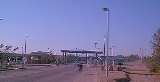
The Beitbridge border post is the busiest road border post in southern Africa.
. The mud houses have since been demolished. Average house occupancy in the low-income and informal settlements varies considerably, as many people do not bring their families to Beitbridge, but includes at least four people. Recreational facilities are limited in low-income areas, consisting largely of bars and soccer pitches.
mine recently closed, increasing unemployment and poverty. Most women rely on vending, sex work and cross-border trading for income. Truckers are present in the area with work coming from the border area of South Africa.
is named after Alfred Beit
, founder of the De Beers
diamond mining company and business associate of Cecil Rhodes. He was also a director of a number of companies, among them the British South Africa Company
and Rhodesia Railways. The bridge was constructed in 1929 at a cost of $220 000 and financed jointly between the Beit Railways Trust and the South African Railways. A new bridge was constructed in 1995, and was officially opened on 24 November. It was built by the Zimbabwean Government
, which now benefits from the toll
s levied on crossings. The new bridge can accommodate much heavier traffic
than the old one could, which is now for rail traffic only.
 On the South African side of the border the N1
Highway
connects this border post to the main economic centres of Pretoria
(463 km) and Johannesburg
(521 km). The closest town is Musina
(16 km). On the Zimbabwean side of the border post the road splits in two, with the A6
running to Bulawayo
and the R1 to Masvingo
. A railway also passes through this border post, side by side with the road, and splits into a line to Bulawayo
and a line to Gweru
via Rutenga
.
Three railway lines meet at Beitbridge: the South Africa
n Spoornet
line to Polokwane
, the National Railways of Zimbabwe
line to Gweru
via Rutenga
and the Beitbridge Bulawayo Railway
.
's date of birth on Saturday, 23 February 2008. On 21 February, two days before, Mugabe
had turned 84. It was reported that workers repaired the usually pot-hole rutted to the main roads in the city to make sure Mugabe
's motorcade moved swiftly with a measure of comfort.
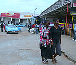
 The town is a staging post for most Zimbabweans fleeing the country en route to South Africa
. Those who cross the border legally are a fraction of those who cross illegally. Many people brave the crocodile infested Limpopo River
and get into South Africa
illegally.
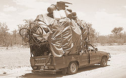
Day-migrants cross the border daily to travel to Musina
, to buy commodities that are usually scarce back in Zimbabwe.
Matabeleland South
Matabeleland South is a province of Zimbabwe. It has an area of 54,172 km² and a population of approximately 650,000 . Gwanda is the capital of the province.-Geography:...
, Zimbabwe
Zimbabwe
Zimbabwe is a landlocked country located in the southern part of the African continent, between the Zambezi and Limpopo rivers. It is bordered by South Africa to the south, Botswana to the southwest, Zambia and a tip of Namibia to the northwest and Mozambique to the east. Zimbabwe has three...
. The name also refers to the border post and bridge spanning the Limpopo River
Limpopo River
The Limpopo River rises in central southern Africa, and flows generally eastwards to the Indian Ocean. It is around long, with a drainage basin in size. Its mean annual discharge is 170 m³/s at its mouth...
, which forms the political border between South Africa
South Africa
The Republic of South Africa is a country in southern Africa. Located at the southern tip of Africa, it is divided into nine provinces, with of coastline on the Atlantic and Indian oceans...
and Zimbabwe
Zimbabwe
Zimbabwe is a landlocked country located in the southern part of the African continent, between the Zambezi and Limpopo rivers. It is bordered by South Africa to the south, Botswana to the southwest, Zambia and a tip of Namibia to the northwest and Mozambique to the east. Zimbabwe has three...
.
Background
The town lies just north of the Limpopo RiverLimpopo River
The Limpopo River rises in central southern Africa, and flows generally eastwards to the Indian Ocean. It is around long, with a drainage basin in size. Its mean annual discharge is 170 m³/s at its mouth...
about 1 km from the Alfred Beit Bridge which spans the Limpopo River between South Africa
South Africa
The Republic of South Africa is a country in southern Africa. Located at the southern tip of Africa, it is divided into nine provinces, with of coastline on the Atlantic and Indian oceans...
and Zimbabwe
Zimbabwe
Zimbabwe is a landlocked country located in the southern part of the African continent, between the Zambezi and Limpopo rivers. It is bordered by South Africa to the south, Botswana to the southwest, Zambia and a tip of Namibia to the northwest and Mozambique to the east. Zimbabwe has three...
. The main roads lead from the border 321 km north-west to Bulawayo
Bulawayo
Bulawayo is the second largest city in Zimbabwe after the capital Harare, with an estimated population in 2010 of 2,000,000. It is located in Matabeleland, 439 km southwest of Harare, and is now treated as a separate provincial area from Matabeleland...
and 585 km north-east to Harare
Harare
Harare before 1982 known as Salisbury) is the largest city and capital of Zimbabwe. It has an estimated population of 1,600,000, with 2,800,000 in its metropolitan area . Administratively, Harare is an independent city equivalent to a province. It is Zimbabwe's largest city and its...
via Masvingo
Masvingo
Masvingo is a town in south-eastern Zimbabwe and the capital of Masvingo Province. The town is close to Great Zimbabwe, the national monument from which the country takes its name.- History :...
. According to the 2002 Population
Population
A population is all the organisms that both belong to the same group or species and live in the same geographical area. The area that is used to define a sexual population is such that inter-breeding is possible between any pair within the area and more probable than cross-breeding with individuals...
Census
Census
A census is the procedure of systematically acquiring and recording information about the members of a given population. It is a regularly occurring and official count of a particular population. The term is used mostly in connection with national population and housing censuses; other common...
, the town had a population of 22,387.It is dominated by the local Venda
Venda
Venda was a bantustan in northern South Africa, now part of Limpopo province. It was founded as a homeland for the Venda people, speakers of the Venda language. It bordered modern Zimbabwe and South Africa, and is now part of Limpopo in South Africa....
people who are also found across the international border in the Vhembe District
District
Districts are a type of administrative division, in some countries managed by a local government. They vary greatly in size, spanning entire regions or counties, several municipalities, or subdivisions of municipalities.-Austria:...
of the Republic of South Africa.
The Beitbridge border post is the busiest road border post in southern Africa.
The Town
Beitbridge has an estimated 2,570 houses in formal settlements (primarily for government officials and mid-level private sector staff) and 3,000 in informal settlements. Formal-settlement dwellings are mainly two- to three-room brick houses, while those in the informal settlements are among the worst mud houses in ZimbabweZimbabwe
Zimbabwe is a landlocked country located in the southern part of the African continent, between the Zambezi and Limpopo rivers. It is bordered by South Africa to the south, Botswana to the southwest, Zambia and a tip of Namibia to the northwest and Mozambique to the east. Zimbabwe has three...
. The mud houses have since been demolished. Average house occupancy in the low-income and informal settlements varies considerably, as many people do not bring their families to Beitbridge, but includes at least four people. Recreational facilities are limited in low-income areas, consisting largely of bars and soccer pitches.
Labour
The major sources of local employment—freight, retail, construction, customs and the police—employ about 1,200 people. Informal sector activities—primarily vending and sex work—are as large as those in the formal sector, employing about 1,400. Outside Beitbridge town, farming is a major employer. A diamondDiamond
In mineralogy, diamond is an allotrope of carbon, where the carbon atoms are arranged in a variation of the face-centered cubic crystal structure called a diamond lattice. Diamond is less stable than graphite, but the conversion rate from diamond to graphite is negligible at ambient conditions...
mine recently closed, increasing unemployment and poverty. Most women rely on vending, sex work and cross-border trading for income. Truckers are present in the area with work coming from the border area of South Africa.
The Bridge
The bridgeBridge
A bridge is a structure built to span physical obstacles such as a body of water, valley, or road, for the purpose of providing passage over the obstacle...
is named after Alfred Beit
Alfred Beit
Alfred Beit was a German, British South African, Jewish gold and diamond magnate, a supporter of British imperialism in Southern Africa and a major donor towards infrastructure development in central and Southern Africa, and to university education and research in several countries.- Life and...
, founder of the De Beers
De Beers
De Beers is a family of companies that dominate the diamond, diamond mining, diamond trading and industrial diamond manufacturing sectors. De Beers is active in every category of industrial diamond mining: open-pit, underground, large-scale alluvial, coastal and deep sea...
diamond mining company and business associate of Cecil Rhodes. He was also a director of a number of companies, among them the British South Africa Company
British South Africa Company
The British South Africa Company was established by Cecil Rhodes through the amalgamation of the Central Search Association and the Exploring Company Ltd., receiving a royal charter in 1889...
and Rhodesia Railways. The bridge was constructed in 1929 at a cost of $220 000 and financed jointly between the Beit Railways Trust and the South African Railways. A new bridge was constructed in 1995, and was officially opened on 24 November. It was built by the Zimbabwean Government
Government
Government refers to the legislators, administrators, and arbitrators in the administrative bureaucracy who control a state at a given time, and to the system of government by which they are organized...
, which now benefits from the toll
Toll bridge
A toll bridge is a bridge over which traffic may pass upon payment of a toll, or fee.- History :The practice of collecting tolls on bridges probably harks back to the days of ferry crossings where people paid a fee to be ferried across stretches of water. As boats became impractical to carry large...
s levied on crossings. The new bridge can accommodate much heavier traffic
Traffic
Traffic on roads may consist of pedestrians, ridden or herded animals, vehicles, streetcars and other conveyances, either singly or together, while using the public way for purposes of travel...
than the old one could, which is now for rail traffic only.
Development
N1 (South Africa)
The N1 is a South African National Route, running from Cape Town to Beit Bridge on the border with Zimbabwe. It is also the main road link between Johannesburg and Cape Town, and forms the first section of the famed Cape to Cairo Road....
Highway
National Roads in South Africa
In South Africa, national routes constitute a numbered network of roads starting with an "N" prefix . They usually connect major centres. Although the terms National Road and National Route are often used interchangably in everyday conversation, the two are not synonymous, and some Regional Routes ...
connects this border post to the main economic centres of Pretoria
Pretoria
Pretoria is a city located in the northern part of Gauteng Province, South Africa. It is one of the country's three capital cities, serving as the executive and de facto national capital; the others are Cape Town, the legislative capital, and Bloemfontein, the judicial capital.Pretoria is...
(463 km) and Johannesburg
Johannesburg
Johannesburg also known as Jozi, Jo'burg or Egoli, is the largest city in South Africa, by population. Johannesburg is the provincial capital of Gauteng, the wealthiest province in South Africa, having the largest economy of any metropolitan region in Sub-Saharan Africa...
(521 km). The closest town is Musina
Musina
Musina or Messina is the northernmost town in the Limpopo province of South Africa near the Limpopo River border to Zimbabwe. It has a population of between 20,000 and 40,000. Iron ore, coal, magnetite, graphite, asbestos, diamonds, semi-precious stones and copper are mined in the...
(16 km). On the Zimbabwean side of the border post the road splits in two, with the A6
A6 road (Zimbabwe)
The A6 is a highway in Zimbabwe running from Beitbridge to Gwanda and Bulawayo.- See also :* Trans-African Highway network...
running to Bulawayo
Bulawayo
Bulawayo is the second largest city in Zimbabwe after the capital Harare, with an estimated population in 2010 of 2,000,000. It is located in Matabeleland, 439 km southwest of Harare, and is now treated as a separate provincial area from Matabeleland...
and the R1 to Masvingo
Masvingo
Masvingo is a town in south-eastern Zimbabwe and the capital of Masvingo Province. The town is close to Great Zimbabwe, the national monument from which the country takes its name.- History :...
. A railway also passes through this border post, side by side with the road, and splits into a line to Bulawayo
Bulawayo
Bulawayo is the second largest city in Zimbabwe after the capital Harare, with an estimated population in 2010 of 2,000,000. It is located in Matabeleland, 439 km southwest of Harare, and is now treated as a separate provincial area from Matabeleland...
and a line to Gweru
Gweru
Gweru is a city near the centre of Zimbabwe at . It has a population of about 146,073 , making it the third largest city in the nation. Gweru is the capital of Midlands Province. Gweru was founded in 1894 by Dr. Leander Starr Jameson. The first bank opened in Gweru in 1896, and the stock exchange...
via Rutenga
Rutenga
Rutenga is a growth point in Masvingo Province in Zimbabwe. It straddles the A4 highway between Beitbridge and Masvingo. It is the defacto capital of Mwenezi .- Background :...
.
Three railway lines meet at Beitbridge: the South Africa
South Africa
The Republic of South Africa is a country in southern Africa. Located at the southern tip of Africa, it is divided into nine provinces, with of coastline on the Atlantic and Indian oceans...
n Spoornet
Spoornet
Transnet Freight Rail is a South African rail transport company, formerly known as Spoornet. It was part of 'South African Railways and Harbours', a state-controlled organisation that employed hundreds of thousands of people for decades from the first half of the 20th century and was widely...
line to Polokwane
Polokwane
Polokwane, meaning "Place of Safety",is a city in the Polokwane Local Municipality and the capital of the Limpopo province, South Africa. It is also often referred to by its former name, Pietersburg. Polokwane is a major urban centre, the biggest and most important north of Gauteng. The population...
, the National Railways of Zimbabwe
National Railways of Zimbabwe
The National Railways of Zimbabwe is the parastatal railway of Zimbabwe. The Zimbabwe railway system was largely constructed during the time of British colonial rule, and part of it represents a segment of the Cape-Cairo railway...
line to Gweru
Gweru
Gweru is a city near the centre of Zimbabwe at . It has a population of about 146,073 , making it the third largest city in the nation. Gweru is the capital of Midlands Province. Gweru was founded in 1894 by Dr. Leander Starr Jameson. The first bank opened in Gweru in 1896, and the stock exchange...
via Rutenga
Rutenga
Rutenga is a growth point in Masvingo Province in Zimbabwe. It straddles the A4 highway between Beitbridge and Masvingo. It is the defacto capital of Mwenezi .- Background :...
and the Beitbridge Bulawayo Railway
Beitbridge Bulawayo Railway
The Beitbridge Bulawayo Railway is a privately owned railway company that provides a rail link in Zimbabwe between Beitbridge at the border to South Africa and Zimbabwe's second city Bulawayo....
.
Venue
Dulivhadzimu Stadium, a small multi-purpose arena in the town was chosen by the ZANU-PF led 21st February Movement to host the annual national celebration of Robert MugabeRobert Mugabe
Robert Gabriel Mugabe is the President of Zimbabwe. As one of the leaders of the liberation movement against white-minority rule, he was elected into power in 1980...
's date of birth on Saturday, 23 February 2008. On 21 February, two days before, Mugabe
Mugabe
Mugabe can refer to:*Robert Mugabe, President of Zimbabwe.*Sally Mugabe, first wife of Robert Mugabe.*Grace Mugabe, second wife of Robert Mugabe.*Omugabe , a title given to kings of Ankole of Uganda.*Mugabe Were, a Kenyan politician....
had turned 84. It was reported that workers repaired the usually pot-hole rutted to the main roads in the city to make sure Mugabe
Mugabe
Mugabe can refer to:*Robert Mugabe, President of Zimbabwe.*Sally Mugabe, first wife of Robert Mugabe.*Grace Mugabe, second wife of Robert Mugabe.*Omugabe , a title given to kings of Ankole of Uganda.*Mugabe Were, a Kenyan politician....
's motorcade moved swiftly with a measure of comfort.
Migrants
South Africa
The Republic of South Africa is a country in southern Africa. Located at the southern tip of Africa, it is divided into nine provinces, with of coastline on the Atlantic and Indian oceans...
. Those who cross the border legally are a fraction of those who cross illegally. Many people brave the crocodile infested Limpopo River
Limpopo River
The Limpopo River rises in central southern Africa, and flows generally eastwards to the Indian Ocean. It is around long, with a drainage basin in size. Its mean annual discharge is 170 m³/s at its mouth...
and get into South Africa
South Africa
The Republic of South Africa is a country in southern Africa. Located at the southern tip of Africa, it is divided into nine provinces, with of coastline on the Atlantic and Indian oceans...
illegally.
Day-migrants cross the border daily to travel to Musina
Musina
Musina or Messina is the northernmost town in the Limpopo province of South Africa near the Limpopo River border to Zimbabwe. It has a population of between 20,000 and 40,000. Iron ore, coal, magnetite, graphite, asbestos, diamonds, semi-precious stones and copper are mined in the...
, to buy commodities that are usually scarce back in Zimbabwe.