

Beaghmore
Encyclopedia
Bronze Age
The Bronze Age is a period characterized by the use of copper and its alloy bronze as the chief hard materials in the manufacture of some implements and weapons. Chronologically, it stands between the Stone Age and Iron Age...
megalith
Megalith
A megalith is a large stone that has been used to construct a structure or monument, either alone or together with other stones. Megalithic describes structures made of such large stones, utilizing an interlocking system without the use of mortar or cement.The word 'megalith' comes from the Ancient...
ic features, stone circle
Stone circle
A stone circle is a monument of standing stones arranged in a circle. Such monuments have been constructed across the world throughout history for many different reasons....
s and cairn
Cairn
Cairn is a term used mainly in the English-speaking world for a man-made pile of stones. It comes from the or . Cairns are found all over the world in uplands, on moorland, on mountaintops, near waterways and on sea cliffs, and also in barren desert and tundra areas...
s, 8.5 miles north west of Cookstown
Cookstown, County Tyrone
Cookstown is a town and townland in County Tyrone, Northern Ireland. It is the fourth largest town in the county and had a population of nearly 11,000 people in the 2001 Census. It is one of the main towns in the area known as Mid-Ulster. It was founded around 1620 when the townlands in the area...
, County Tyrone
County Tyrone
Historically Tyrone stretched as far north as Lough Foyle, and comprised part of modern day County Londonderry east of the River Foyle. The majority of County Londonderry was carved out of Tyrone between 1610-1620 when that land went to the Guilds of London to set up profit making schemes based on...
in Northern Ireland
Northern Ireland
Northern Ireland is one of the four countries of the United Kingdom. Situated in the north-east of the island of Ireland, it shares a border with the Republic of Ireland to the south and west...
, on the south-east edge of the Sperrin Mountains
Sperrins
The Sperrins or Sperrin Mountains are a range of mountains in Northern Ireland and one of the largest upland areas in Ireland. The range stretches the counties of Tyrone and Londonderry from south of Strabane eastwards to Maghera and north towards Limavady...
. Some documents suggest that Beaghmore translates into English as 'the moor of the birches' but this is plainly wrong, as there is no Irish word for moor that sounds like the English word moor (the usual word is caorán) - Mackay's Dictionary of Ulster Place-names says that it is from an Bheitheach Mhór, meaning "big place of birch trees"; a name that reflects the fact that the area was a woodland before being cleared by Neolithic
Neolithic
The Neolithic Age, Era, or Period, or New Stone Age, was a period in the development of human technology, beginning about 9500 BC in some parts of the Middle East, and later in other parts of the world. It is traditionally considered as the last part of the Stone Age...
farmers. Beaghmore stone circles, alignments and cairns are State Care Historic Monuments in the townland
Townland
A townland or bally is a small geographical division of land used in Ireland. The townland system is of Gaelic origin—most townlands are believed to pre-date the Norman invasion and most have names derived from the Irish language...
of Beaghmore, in the Cookstown District Council
Cookstown District Council
Cookstown District Council is a district council covering an area largely in County Tyrone and partly in County Londonderry. Council headquarters are in Cookstown. Small towns in the council area include Pomeroy, Moneymore, Coagh and Stewartstown and in the east the area is bounded by Lough Neagh...
area, grid ref: Area of
H684 842. At Beaghmore a cairn (grid ref: H6872 8470), a cairn (grid ref: H6856 8472), Stone circles, alignments and cairns (grid ref: area of H684 842), round cairn with
standing stones: Bradley’s Cairn (grid ref: H6830 8401) and cairn and alignment (grid ref: H6863 8431), are all Scheduled Historic Monuments.
Excavation
The site was discovered in the early 1940s during peatPeat
Peat is an accumulation of partially decayed vegetation matter or histosol. Peat forms in wetland bogs, moors, muskegs, pocosins, mires, and peat swamp forests. Peat is harvested as an important source of fuel in certain parts of the world...
cutting when 1,269 stones were uncovered, and partially excavated in 1945-1949 when it was taken into state care. It was also excavated again in 1965. Investigation of the site and the surrounding bog indicate that the area was occupied since Neolithic times through the Bronze Age. The stone circles and cairn are attributed to the earlier part of the Bronze Age c. 2,000-1,200 BC. It is possible that the full extent of the complex has not yet been revealed and further stones and cairns may still lie hidden in the adjacent peat. Hearths and deposits of flint tools were discovered and have been carbon dated to 2900-2600BC. Several of the stone rows run over the tumbled walls of field structures which also date from the Neolithic period. Excavation of one of the cairns revealed a polished porcellanite
Porcellanite
Porcellanite or porcelanite, is a hard, dense rock somewhat similar in appearance to unglazed porcelain. It is often an impure variety of chert containing clay and calcareous matter....
axe, which may have originated from the Tievebulliagh
Tievebulliagh
Tievebulliagh is a 402m high mountain in the Glens of Antrim, Northern Ireland. It forms part of the watershed between Glenann to the north and Glenballyeamon to the south...
axe factory, some 70 miles away in County Antrim
County Antrim
County Antrim is one of six counties that form Northern Ireland, situated in the north-east of the island of Ireland. Adjoined to the north-east shore of Lough Neagh, the county covers an area of 2,844 km², with a population of approximately 616,000...
. The largest cairn featured a central pit containing an oak branch.
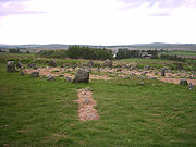
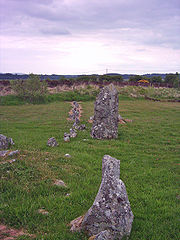
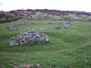
Features
There are seven low stone circles of different sizes, six of which are paired, twelve cairns and ten stone rowStone row
A stone row , is a linear arrangement of upright, parallel megalithic standing stones set at intervals along a common axis or series of axes, usually dating from the later Neolithic or Bronze Age. Rows may be individual or grouped, and three or more stones aligned can constitute a stone row...
s. The circles are between 10 and 20m in diameter, and are associated with earlier burial cairns and alignments of stone rows lead towards them. The stones are small with few more than 0.5m in height and the circles are distorted, suggesting they are related to kerb
Megalithic architectural elements
This article describes several characteristic architectural elements typical of European megalithic structures.-Forecourt:In archaeology, a forecourt is the name given to the area in front of certain types of chamber tomb...
s surrounding some megalithic tombs. The singular circle is distinguished from the paired circles by its slightly larger stones. It is also unique in that the interior of the circle is filled with more than 800 small stones which have been placed upright within the circle and are known as "the dragon’s teeth". Most of these circles have small stone alignments touching them at a tangent. The site also includes a dozen small stone cairns, frequently covering a cremation burial. Each of the three pairs of stone circles have a small cairn placed in between. A typical feature of the stone rows is a high and low arrangement where short rows of tall stones run beside much longer rows of small stones. The stone rows radiate from the circles in a roughly north-east direction.
The site also consists of low banks of small stones running below, and possibly pre-dating, the other structures which may have been field walls in the Neolithic period. Excavation has revealed that the site overlays a Neolithic cultivation site, and it is thought that the stones may have been erected in response to deteriorating soil fertility and the encroachment of peat. Following excavation a system of drainage channels had to be laid to prevent the stones from being reclaimed once again by the bog.
Function
Possibly the site could mark a focal point for religious and/or social gatherings. Some archaeologists believe that the circles have been constructed in relation to the rising of the sun at the solsticeSolstice
A solstice is an astronomical event that happens twice each year when the Sun's apparent position in the sky, as viewed from Earth, reaches its northernmost or southernmost extremes...
, or to record the movements of the sun and moon acting as observatories for particular lunar, solar or stellar events. Three of the stone rows point to the sunrise at the time of the solstice and another is aligned towards moonrise at the same period. However, most of the remains at Beaghmore do not indicate very accurate alignments upon specific astronomical features.
Because of the number of stone cairns on the site it is possible that at least part of the function of the site was burial. Some cairns have been found to hold cremated human remains, occasionally contained in a small cist. But not all the cairns have burial remains and they could have had other purposes, or perhaps are simply accumulations of surplus stones.
Sources
- McNally, Kenneth (2006). "Ireland's Ancient Stones" (Belfast: Appletree Press). ISBN 0-8628-1996-2