Tievebulliagh
Encyclopedia
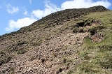
Tievebulliagh is a 402m high mountain in the Glens of Antrim
, Northern Ireland
. It forms part of the watershed
between Glenann to the north and Glenballyeamon to the south. It is situated about 4.4 km from Cushendall
.
, the intense heat generated by molten basalt has given rise to the formation of a durable flint, porcellanite
, which is found at the foot of the eastern scree slope of the mountain. Three small outcrops of porcellanite can be seen on the higher south-east slope.
 Evidence has been discovered of a Neolithic
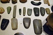
axe quarry at the foot of Tievebulliagh. Flint axe heads fashioned from porcellanite
that originate from this quarry have been found across the British Isles
, from the Outer Hebrides
to the south coast of England
and across the rest of Ireland
. The site compares with the Langdale axe industry
based in the English Lake District and the quarries at Penmaenmawr
in North Wales
, where large numbers of stone axes were manufactured.
Flakes, rejects and part-finished axes can still be found round the hill and peak. It was here that the axes were roughed out before being finished at the sea shore. They were then exported as far afield as south-west Ireland, south-east England
and north-east Scotland
. No finished axes have been found, only unfinished and rejected ones.
There is a Bronze Age
cairn on the mountain top. The round cairn and Neolithic
axe factory on Tievebulliagh are Scheduled Historic Monuments sited in the townland
of Cloghs, in Moyle District Council
area, at grid ref: area of
D193 266.
Glens of Antrim
The Glens of Antrim , known locally as simply The Glens, is a region of County Antrim, Northern Ireland. It comprises nine glens , that radiate from the Antrim Plateau to the coast. The Glens are an area of outstanding natural beauty and are a major tourist attraction in north Antrim...
, Northern Ireland
Northern Ireland
Northern Ireland is one of the four countries of the United Kingdom. Situated in the north-east of the island of Ireland, it shares a border with the Republic of Ireland to the south and west...
. It forms part of the watershed
Water divide
A drainage divide, water divide, divide or watershed is the line separating neighbouring drainage basins...
between Glenann to the north and Glenballyeamon to the south. It is situated about 4.4 km from Cushendall
Cushendall
Cushendall and formerly known as Newtown Glens is a village and townland in County Antrim, Northern Ireland.It is on the A2 coast road between Glenariff and Cushendun, in the Antrim Coast and Glens Area of Outstanding Natural Beauty...
.
Geology
Tievebulliagh is formed from a volcanic plugVolcanic plug
A volcanic plug, also called a volcanic neck or lava neck, is a volcanic landform created when magma hardens within a vent on an active volcano. When forming, a plug can cause an extreme build-up of pressure if volatile-charged magma is trapped beneath it, and this can sometimes lead to an...
, the intense heat generated by molten basalt has given rise to the formation of a durable flint, porcellanite
Porcellanite
Porcellanite or porcelanite, is a hard, dense rock somewhat similar in appearance to unglazed porcelain. It is often an impure variety of chert containing clay and calcareous matter....
, which is found at the foot of the eastern scree slope of the mountain. Three small outcrops of porcellanite can be seen on the higher south-east slope.
Archaeology

Neolithic
The Neolithic Age, Era, or Period, or New Stone Age, was a period in the development of human technology, beginning about 9500 BC in some parts of the Middle East, and later in other parts of the world. It is traditionally considered as the last part of the Stone Age...
axe quarry at the foot of Tievebulliagh. Flint axe heads fashioned from porcellanite
Porcellanite
Porcellanite or porcelanite, is a hard, dense rock somewhat similar in appearance to unglazed porcelain. It is often an impure variety of chert containing clay and calcareous matter....
that originate from this quarry have been found across the British Isles
British Isles
The British Isles are a group of islands off the northwest coast of continental Europe that include the islands of Great Britain and Ireland and over six thousand smaller isles. There are two sovereign states located on the islands: the United Kingdom of Great Britain and Northern Ireland and...
, from the Outer Hebrides
Outer Hebrides
The Outer Hebrides also known as the Western Isles and the Long Island, is an island chain off the west coast of Scotland. The islands are geographically contiguous with Comhairle nan Eilean Siar, one of the 32 unitary council areas of Scotland...
to the south coast of England
England
England is a country that is part of the United Kingdom. It shares land borders with Scotland to the north and Wales to the west; the Irish Sea is to the north west, the Celtic Sea to the south west, with the North Sea to the east and the English Channel to the south separating it from continental...
and across the rest of Ireland
Ireland
Ireland is an island to the northwest of continental Europe. It is the third-largest island in Europe and the twentieth-largest island on Earth...
. The site compares with the Langdale axe industry
Langdale axe industry
The Langdale axe industry is the name given by archaeologists to the centre of a specialised stone tool manufacturing at Great Langdale in England's Lake District during the Neolithic period .The area has outcrops of fine-grained greenstone suitable for making polished axes which have been...
based in the English Lake District and the quarries at Penmaenmawr
Penmaenmawr
PenmaenmawrConwyPenmaenmawr is a town in the parish of Dwygyfylchi, in Conwy County Borough, Wales. The population was 3857 in 2001. It is a quarrying town, though the latter is no longer a major employer, on the North Wales coast between Conwy and Llanfairfechan.The town was bypassed by the A55...
in North Wales
North Wales
North Wales is the northernmost unofficial region of Wales. It is bordered to the south by the counties of Ceredigion and Powys in Mid Wales and to the east by the counties of Shropshire in the West Midlands and Cheshire in North West England...
, where large numbers of stone axes were manufactured.
Flakes, rejects and part-finished axes can still be found round the hill and peak. It was here that the axes were roughed out before being finished at the sea shore. They were then exported as far afield as south-west Ireland, south-east England
England
England is a country that is part of the United Kingdom. It shares land borders with Scotland to the north and Wales to the west; the Irish Sea is to the north west, the Celtic Sea to the south west, with the North Sea to the east and the English Channel to the south separating it from continental...
and north-east Scotland
Scotland
Scotland is a country that is part of the United Kingdom. Occupying the northern third of the island of Great Britain, it shares a border with England to the south and is bounded by the North Sea to the east, the Atlantic Ocean to the north and west, and the North Channel and Irish Sea to the...
. No finished axes have been found, only unfinished and rejected ones.
There is a Bronze Age
Bronze Age
The Bronze Age is a period characterized by the use of copper and its alloy bronze as the chief hard materials in the manufacture of some implements and weapons. Chronologically, it stands between the Stone Age and Iron Age...
cairn on the mountain top. The round cairn and Neolithic
Neolithic
The Neolithic Age, Era, or Period, or New Stone Age, was a period in the development of human technology, beginning about 9500 BC in some parts of the Middle East, and later in other parts of the world. It is traditionally considered as the last part of the Stone Age...
axe factory on Tievebulliagh are Scheduled Historic Monuments sited in the townland
Townland
A townland or bally is a small geographical division of land used in Ireland. The townland system is of Gaelic origin—most townlands are believed to pre-date the Norman invasion and most have names derived from the Irish language...
of Cloghs, in Moyle District Council
Moyle District Council
Moyle District Council is a Local Council in County Antrim in the north-east corner of Northern Ireland. It covers a largely rural area of approximately 190 square miles and has a population of 15,000...
area, at grid ref: area of
D193 266.

