

Beaches in Port Phillip
Encyclopedia
Port Phillip
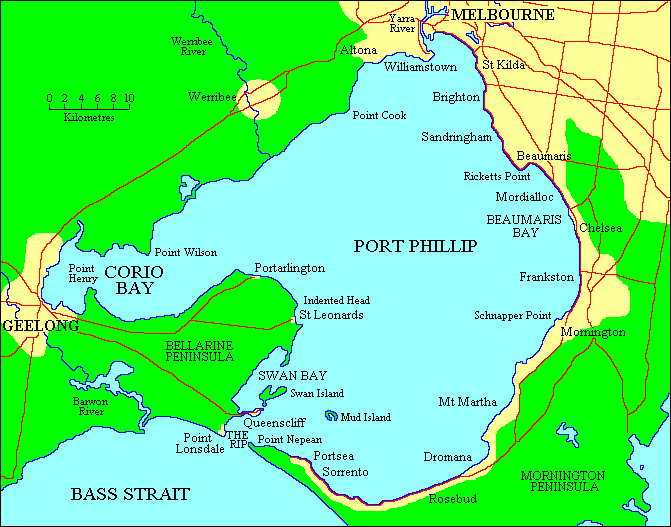
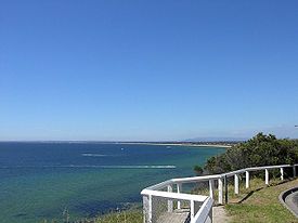
Port Phillip Port Phillip Port Phillip (also commonly referred to as Port Phillip Bay or (locally) just The Bay, is a large bay in southern Victoria, Australia; it is the location of Melbourne. Geographically, the bay covers and the shore stretches roughly . Although it is extremely shallow for...
is a bay in central Victoria. It hosts many beach
Beach
A beach is a geological landform along the shoreline of an ocean, sea, lake or river. It usually consists of loose particles which are often composed of rock, such as sand, gravel, shingle, pebbles or cobblestones...
es, most of which are flat, shallow and long, with very small breaks making swimming quite safe. This attracts many tourists, mostly families, to the beaches of Port Phillip during the summer months and school holidays. Water sports such as body boarding and surfing
Surfing
Surfing' is a surface water sport in which the surfer rides a surfboard on the crest and face of a wave which is carrying the surfer towards the shore...
are difficult or impossible, except in extreme weather conditions. Most sandy beaches are located on the bay's northern, eastern and southern shorelines, while the western shorelines host a few sandy beaches, there mostly exists a greater variety of beaches, swampy wetlands and mangroves. The occasional pebble beach and rocky cliffs can also be found, mostly in the southern reaches.
Beaches
Hobsons Bay
- Yarra RiverYarra RiverThe Yarra River, originally Birrarung, is a river in east-central Victoria, Australia. The lower stretches of the river is where the city of Melbourne was established in 1835 and today Greater Melbourne dominates and influences the landscape of its lower reaches...
- Sandridge Beach - Port Melbourne
- Port Melbourne Beach - Port Melbourne
- South Melbourne Beach - Albert ParkAlbert Park, VictoriaAlbert Park is an inner city suburb of Melbourne, Victoria, Australia, 3 km south from Melbourne's central business district. Its Local Government Area is the City of Port Phillip. At the 2006 Census, Albert Park had a population of 5827....
- West Beach - St. Kilda West
- St Kilda Beach - St. Kilda
Between Hobsons & Beaumaris Bays
- Elwood Beach - ElwoodElwood, VictoriaElwood is a suburb in Melbourne, Victoria, Australia, 8 km south from Melbourne's central business district. Its Local Government Area is the City of Port Phillip...
- Seacombe Grove Beach - BrightonBrighton, VictoriaBrighton is a suburb of Melbourne, Victoria, Australia, 11 km south-east from Melbourne's central business district. Its Local Government Area is the City of Bayside. At the 2006 Census, Brighton had a population of 20,651...
- Middle Brighton Beach - BrightonBrighton, VictoriaBrighton is a suburb of Melbourne, Victoria, Australia, 11 km south-east from Melbourne's central business district. Its Local Government Area is the City of Bayside. At the 2006 Census, Brighton had a population of 20,651...
- Dendy Street Beach - BrightonBrighton, VictoriaBrighton is a suburb of Melbourne, Victoria, Australia, 11 km south-east from Melbourne's central business district. Its Local Government Area is the City of Bayside. At the 2006 Census, Brighton had a population of 20,651...
- Brighton Beach - BrightonBrighton, VictoriaBrighton is a suburb of Melbourne, Victoria, Australia, 11 km south-east from Melbourne's central business district. Its Local Government Area is the City of Bayside. At the 2006 Census, Brighton had a population of 20,651...
- Hampton Beach - HamptonHampton, VictoriaHampton is a suburb in Melbourne, Victoria, Australia, 14 km south east from Melbourne's central business district. Its Local Government Area is the City of Bayside. At the 2006 Census, Hampton had a population of 11,825.Hampton is located in a wealthy bayside area of Melbourne, wedged between the...
- Sandringham Beach - SandringhamSandringham, VictoriaSandringham is a suburb in Melbourne, Victoria, Australia, 16 km south-east from Melbourne's central business district. Its Local Government Area is the City of Bayside. At the 2006 Census, Sandringham had a population of 8693.-History:...
- Half Moon Bay Beach - Black RockBlack Rock, VictoriaBlack Rock is a suburb in Melbourne, Victoria, Australia, 18 km south-east from Melbourne's central business district. Its Local Government Area is the City of Bayside. At the 2006 Census, Black Rock had a population of 5796.-History:...
- Black Rock Beach - Black RockBlack Rock, VictoriaBlack Rock is a suburb in Melbourne, Victoria, Australia, 18 km south-east from Melbourne's central business district. Its Local Government Area is the City of Bayside. At the 2006 Census, Black Rock had a population of 5796.-History:...
- Ricketts Point Beach - Black RockBlack Rock, VictoriaBlack Rock is a suburb in Melbourne, Victoria, Australia, 18 km south-east from Melbourne's central business district. Its Local Government Area is the City of Bayside. At the 2006 Census, Black Rock had a population of 5796.-History:...
- Watkins Bay Beach
- Keefers Cove Beach
Beaumaris BayBeaumaris BayBeaumaris Bay is a bay in Port Phillip, Victoria, Australia....
- Mentone Beach - MentoneMentone, VictoriaMentone is a suburb in Melbourne, Victoria, Australia, 21 km south-east from Melbourne's central business district. Its Local Government Area is the City of Kingston...
- Parkdale Beach - ParkdaleParkdale, VictoriaParkdale is a suburb in Melbourne, Victoria, Australia, 23 km south-east from Melbourne's central business district. Its Local Government Area is the City of Kingston...
- Mordialloc Beach - MordiallocMordialloc, VictoriaMordialloc is a suburb in Melbourne, Victoria, Australia, 24 km south-east from Melbourne's central business district. Its Local Government Area is the City of Kingston...
- Aspendale Beach - AspendaleAspendale, VictoriaAspendale is a suburb in Melbourne, Victoria, Australia, 27 km south-east from Melbourne's central business district. Its Local Government Area is the City of Kingston...
- Edithvale Beach - EdithvaleEdithvale, VictoriaEdithvale is a suburb in Melbourne, Victoria, Australia, 28 km south-east from Melbourne's central business district. Its Local Government Area is the City of Kingston. At the 2006 Census, Edithvale had a population of 4991.-Public transport:...
- Chelsea Beach - ChelseaChelsea, VictoriaChelsea is a suburb in Melbourne, Victoria, Australia, 30 km south-east from Melbourne's central business district. Its Local Government Area is the City of Kingston. At the 2006 Census, Chelsea had a population of 6694....
- Bonbeach Beach - BonbeachBonbeach, VictoriaBonbeach is a suburb in Melbourne, Victoria, Australia, 31 km south-east from Melbourne's central business district. Its Local Government Area is the City of Kingston...
- Carrum Beach - CarrumCarrum, VictoriaCarrum is a suburb in Melbourne, Victoria, Australia, south-east from Melbourne's central business district. Its Local Government Area is the City of Kingston...
- Seaford Beach - SeafordSeaford, VictoriaSeaford is a suburb in Melbourne, Victoria, Australia, 36 km south-east from Melbourne's central business district. Its Local Government Area is the City of Frankston...
- Long Island Beach
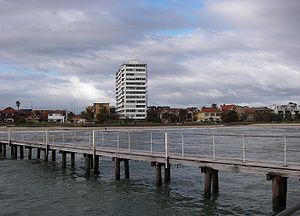
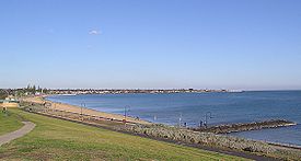
- Frankston Beach - FrankstonFrankston, VictoriaFrankston is a suburb within the Greater Melbourne metropolitan area in Victoria, Australia. It is located 40 km southeast of the state capital Melbourne at the southernmost edge of Greater Melbourne, near the beginnings of the Mornington Peninsula...
- South Frankston Beach - FrankstonFrankston, VictoriaFrankston is a suburb within the Greater Melbourne metropolitan area in Victoria, Australia. It is located 40 km southeast of the state capital Melbourne at the southernmost edge of Greater Melbourne, near the beginnings of the Mornington Peninsula...
/Frankston SouthFrankston South, VictoriaFrankston South is a suburb in Melbourne, Victoria, Australia, 43 km south-east from Melbourne's central business district. Its Local Government Area is the City of Frankston...
- Frankston Beach - Frankston
Between Beaumaris & Dromana Bays
- Daveys Bay BeachDaveys BayDaveys Bay is a small shallow bay in Port Phillip, Victoria, Australia. It is one of several small bays adjoining the small town of Mount Eliza and is the closest region of the Shire of Mornington Peninsula to Melbourne....
- Mount ElizaMount Eliza, VictoriaMount Eliza is an outer suburb south-east of Melbourne, Victoria, Australia. It is in the Local Government Area of the Shire of Mornington Peninsula... - Mount Eliza Beach - Mount ElizaMount Eliza, VictoriaMount Eliza is an outer suburb south-east of Melbourne, Victoria, Australia. It is in the Local Government Area of the Shire of Mornington Peninsula...
- Canadian Bay Beach
- Half Moon Bay Beach - Mount ElizaMount Eliza, VictoriaMount Eliza is an outer suburb south-east of Melbourne, Victoria, Australia. It is in the Local Government Area of the Shire of Mornington Peninsula...
- Ranelagh Beach - Mount ElizaMount Eliza, VictoriaMount Eliza is an outer suburb south-east of Melbourne, Victoria, Australia. It is in the Local Government Area of the Shire of Mornington Peninsula...
- Moondah Beach - Mount ElizaMount Eliza, VictoriaMount Eliza is an outer suburb south-east of Melbourne, Victoria, Australia. It is in the Local Government Area of the Shire of Mornington Peninsula...
- Sunnyside North BeachSunnyside North BeachSunnyside North Beach is a clothes-optional beach located at Mount Eliza, Port Philip Bay, in the State of Victoria, Australia. It is designated as a legal nudist beach under the Nudity Act 1983.-About the beach:...
- Mount ElizaMount Eliza, VictoriaMount Eliza is an outer suburb south-east of Melbourne, Victoria, Australia. It is in the Local Government Area of the Shire of Mornington Peninsula... - Sunnyside Beach - Mount ElizaMount Eliza, VictoriaMount Eliza is an outer suburb south-east of Melbourne, Victoria, Australia. It is in the Local Government Area of the Shire of Mornington Peninsula...
- Mills Beach - MorningtonMornington, VictoriaMornington is a sea side town on the Mornington Peninsula, Victoria, Australia, located 57 km south-east of Melbourne's central business district. It is in the Local Government Area of the Shire of Mornington Peninsula....
- Half Moon Bay Beach - Mount Eliza
- Mills Beach East
- Shire Hall Beach - MorningtonMornington, VictoriaMornington is a sea side town on the Mornington Peninsula, Victoria, Australia, located 57 km south-east of Melbourne's central business district. It is in the Local Government Area of the Shire of Mornington Peninsula....
- Mothers Beach - MorningtonMornington, VictoriaMornington is a sea side town on the Mornington Peninsula, Victoria, Australia, located 57 km south-east of Melbourne's central business district. It is in the Local Government Area of the Shire of Mornington Peninsula....
- Royal Beach - MorningtonMornington, VictoriaMornington is a sea side town on the Mornington Peninsula, Victoria, Australia, located 57 km south-east of Melbourne's central business district. It is in the Local Government Area of the Shire of Mornington Peninsula....
- Fishermans Beach - MorningtonMornington, VictoriaMornington is a sea side town on the Mornington Peninsula, Victoria, Australia, located 57 km south-east of Melbourne's central business district. It is in the Local Government Area of the Shire of Mornington Peninsula....
- Fosters Beach - MorningtonMornington, VictoriaMornington is a sea side town on the Mornington Peninsula, Victoria, Australia, located 57 km south-east of Melbourne's central business district. It is in the Local Government Area of the Shire of Mornington Peninsula....
- Shire Hall Beach - Mornington
- Fosters Slip
- Fossil Beach - MorningtonMornington, VictoriaMornington is a sea side town on the Mornington Peninsula, Victoria, Australia, located 57 km south-east of Melbourne's central business district. It is in the Local Government Area of the Shire of Mornington Peninsula....
- Dava Beach - Mount MarthaMount Martha, VictoriaMount Martha is a suburb in Melbourne, Victoria, Australia, located 60 km south-east of Melbourne's central business district. Its Local Government Area is the Shire of Mornington Peninsula. It is located on the south-eastern shores of Port Phillip and offers a bathing beach...
- Birdrock Beach - Mount MarthaMount Martha, VictoriaMount Martha is a suburb in Melbourne, Victoria, Australia, located 60 km south-east of Melbourne's central business district. Its Local Government Area is the Shire of Mornington Peninsula. It is located on the south-eastern shores of Port Phillip and offers a bathing beach...
- Craigie Beach - Mount MarthaMount Martha, VictoriaMount Martha is a suburb in Melbourne, Victoria, Australia, located 60 km south-east of Melbourne's central business district. Its Local Government Area is the Shire of Mornington Peninsula. It is located on the south-eastern shores of Port Phillip and offers a bathing beach...
- Hawker Beach - Mount MarthaMount Martha, VictoriaMount Martha is a suburb in Melbourne, Victoria, Australia, located 60 km south-east of Melbourne's central business district. Its Local Government Area is the Shire of Mornington Peninsula. It is located on the south-eastern shores of Port Phillip and offers a bathing beach...
- Mount Martha Beach North - Mount MarthaMount Martha, VictoriaMount Martha is a suburb in Melbourne, Victoria, Australia, located 60 km south-east of Melbourne's central business district. Its Local Government Area is the Shire of Mornington Peninsula. It is located on the south-eastern shores of Port Phillip and offers a bathing beach...
- Mount Martha Beach South - Mount MarthaMount Martha, VictoriaMount Martha is a suburb in Melbourne, Victoria, Australia, located 60 km south-east of Melbourne's central business district. Its Local Government Area is the Shire of Mornington Peninsula. It is located on the south-eastern shores of Port Phillip and offers a bathing beach...
- Fossil Beach - Mornington
Dromana Bay
- Pebble Cove Beach - Mount MarthaMount Martha, VictoriaMount Martha is a suburb in Melbourne, Victoria, Australia, located 60 km south-east of Melbourne's central business district. Its Local Government Area is the Shire of Mornington Peninsula. It is located on the south-eastern shores of Port Phillip and offers a bathing beach...
- Safety Beach - Safety BeachSafety Beach, VictoriaSafety Beach is a suburb in Melbourne, Victoria, Australia. Its Local Government Area is the Shire of Mornington Peninsula.Safety Beach occupies slightly less than half the area of land between the foothills of Mount Martha and Arthurs Seat and borders Port Philip Bay to its west.There is a large...
- Dromana Beach - DromanaDromana, VictoriaDromana is a suburb south of Melbourne, the capital city of Victoria, Australia, and is located on the Mornington Peninsula. Its Local Government Area is the Shire of Mornington Peninsula.-Geography:...
- Anthonys Nose Beach - DromanaDromana, VictoriaDromana is a suburb south of Melbourne, the capital city of Victoria, Australia, and is located on the Mornington Peninsula. Its Local Government Area is the Shire of Mornington Peninsula.-Geography:...
Capel Sound
- McCrae Beach - McCraeMcCrae, VictoriaMcCrae is a suburb in Melbourne, Victoria, Australia. Its Local Government Area is the Shire of Mornington Peninsula. McCrae is known for the McCrae Lighthouse...
- Rosebud Beach - RosebudRosebud, VictoriaRosebud is a sea side town on the Mornington Peninsula, Victoria, Australia located approximately 75 km southeast of the Melbourne City Centre. It is wedged between the lower slopes of Arthurs Seat, the shores of Port Phillip Bay and the plains of Boneo. Its Local Government Area is the...
- Rosebud West Beach - Rosebud WestRosebud West, VictoriaRosebud West is a suburb in Melbourne, Victoria, Australia. Its Local Government Area is the Shire of Mornington Peninsula.Rosebud West Post Office opened on 12 January 1938 and closed around 1996. -External links:...
- Tootgarook Beach - TootgarookTootgarook, VictoriaTootgarook is located approximately 81 km from Melbourne, Victoria, Australia. Its Local Government Area is the Shire of Mornington Peninsula.-History:...
- Rye Beach - RyeRye, VictoriaRye is a seaside resort town, approximately 83 km south of Melbourne, Victoria, Australia, on the Mornington Peninsula, Victoria, Australia. Its bay beach is popular with swimmers, fishermen, yachtsmen and kitesurfers. Its ocean beach is also popular with surfers...
- Rye Beach East
- Rye Beach West
- Tyrone Beach - RyeRye, VictoriaRye is a seaside resort town, approximately 83 km south of Melbourne, Victoria, Australia, on the Mornington Peninsula, Victoria, Australia. Its bay beach is popular with swimmers, fishermen, yachtsmen and kitesurfers. Its ocean beach is also popular with surfers...
- Blairgowrie Beach - BlairgowrieBlairgowrie, VictoriaBlairgowrie is a seaside village approximately 87 km from Melbourne, Victoria, Australia. Its Local Government Area is the Shire of Mornington Peninsula.-History:...
- Camerons Bight Beach - SorrentoSorrento, VictoriaSorrento is a township in Victoria, Australia, located on the shores of Port Phillip on the Mornington Peninsula, about one and a half hours south of Melbourne...
- Sullivan Bay Beach - SorrentoSorrento, VictoriaSorrento is a township in Victoria, Australia, located on the shores of Port Phillip on the Mornington Peninsula, about one and a half hours south of Melbourne...
- Sorrento Front Beach - SorrentoSorrento, VictoriaSorrento is a township in Victoria, Australia, located on the shores of Port Phillip on the Mornington Peninsula, about one and a half hours south of Melbourne...
- Policemans Point Beach - SorrentoSorrento, VictoriaSorrento is a township in Victoria, Australia, located on the shores of Port Phillip on the Mornington Peninsula, about one and a half hours south of Melbourne...
- Tyrone Beach - Rye
Point Nepean Beaches
- Shelley Beach - PortseaPortsea, VictoriaPortsea is a resort town located across Port Phillip from Melbourne, Victoria, Australia. Its Local Government Area is the Shire of Mornington Peninsula....
- Portsea Front Beach - PortseaPortsea, VictoriaPortsea is a resort town located across Port Phillip from Melbourne, Victoria, Australia. Its Local Government Area is the Shire of Mornington Peninsula....
- Ticonderoga Beach - PortseaPortsea, VictoriaPortsea is a resort town located across Port Phillip from Melbourne, Victoria, Australia. Its Local Government Area is the Shire of Mornington Peninsula....
- Observatory Point Beach - PortseaPortsea, VictoriaPortsea is a resort town located across Port Phillip from Melbourne, Victoria, Australia. Its Local Government Area is the Shire of Mornington Peninsula....
(unstable sand dunes) - Nepean Bay Beaches - PortseaPortsea, VictoriaPortsea is a resort town located across Port Phillip from Melbourne, Victoria, Australia. Its Local Government Area is the Shire of Mornington Peninsula....
(dangerous, no public access) - The RipThe Rip"The Rip", also known as "The Heads", is a dangerous stretch of water in Victoria, Australia, connecting Port Phillip and Bass Strait. It is the only entrance for shipping into Port Phillip and hence into Melbourne. Because of large tidal flows through the relatively narrow channel from the bay to...
Lonsdale Bay
- The RipThe Rip"The Rip", also known as "The Heads", is a dangerous stretch of water in Victoria, Australia, connecting Port Phillip and Bass Strait. It is the only entrance for shipping into Port Phillip and hence into Melbourne. Because of large tidal flows through the relatively narrow channel from the bay to...
- Pier Beach - Point LonsdalePoint Lonsdale, VictoriaPoint Lonsdale is a coastal township on the Bellarine Peninsula, near Queenscliff, Victoria, Australia, and included in the Borough of Queenscliffe. Point Lonsdale is also one of the headlands which, with Point Nepean, frame The Rip, the entrance to Port Phillip. The headland is dominated by the...
- Point Lonsdale Front Beach - Point LonsdalePoint Lonsdale, VictoriaPoint Lonsdale is a coastal township on the Bellarine Peninsula, near Queenscliff, Victoria, Australia, and included in the Borough of Queenscliffe. Point Lonsdale is also one of the headlands which, with Point Nepean, frame The Rip, the entrance to Port Phillip. The headland is dominated by the...
- Springs Beach - Point LonsdalePoint Lonsdale, VictoriaPoint Lonsdale is a coastal township on the Bellarine Peninsula, near Queenscliff, Victoria, Australia, and included in the Borough of Queenscliffe. Point Lonsdale is also one of the headlands which, with Point Nepean, frame The Rip, the entrance to Port Phillip. The headland is dominated by the...
- Narrows Beach - QueenscliffQueenscliff, VictoriaQueenscliff is a small town on the Bellarine Peninsula in southern Victoria, Australia, south of Swan Bay at the entrance to Port Phillip. It is the administrative centre for the Borough of Queenscliffe...
(approved dog beach) - Santa Casa Beach - QueenscliffQueenscliff, VictoriaQueenscliff is a small town on the Bellarine Peninsula in southern Victoria, Australia, south of Swan Bay at the entrance to Port Phillip. It is the administrative centre for the Borough of Queenscliffe...
- Queenscliff Beach - QueenscliffQueenscliff, VictoriaQueenscliff is a small town on the Bellarine Peninsula in southern Victoria, Australia, south of Swan Bay at the entrance to Port Phillip. It is the administrative centre for the Borough of Queenscliffe...
Between Lonsdale & Corio Bays
- The Bluff Beach - St LeonardsSt Leonards, VictoriaSt Leonards is a coastal township near Geelong, Victoria, Australia, at the eastern end of the Bellarine Peninsula and the northern end of Swan Bay...
- St Leonards Beach - St Leonards
- Indented Head Beach - Indented HeadIndented Head, VictoriaIndented Head is a small coastal township located on the Bellarine Peninsula, east of Geelong, in the Australian state of Victoria. The town lies on the coast of the Port Phillip bay between the towns of Portarlington and St Leonards.-History:...
- Half Moon Bay Beach - Indented Head
- Indented Head Northern Beaches - Indented Head
- Portarlington Eastern Beaches - PortarlingtonPortarlington, VictoriaPortarlington is a historic coastal township located on the Bellarine Peninsula, 27km from the city of Geelong, in the state of Victoria, Australia. The gently rising hills behind the town feature vineyards and olive groves, overlooking Port Phillip Bay. Portarlington is a popular family holiday...
- Portarlington Beach - Portarlington
- The Dell - Clifton SpringsClifton Springs, VictoriaClifton Springs is a coastal town located on the Bellarine Peninsula, near Geelong, Victoria, Australia, named after local mineral springs, which were found around Fairy Dell, which was closed due to possible landslides however re-opened in 2007 after extensive work repairing the area.-History:A...
Corio Bay
- Point Henry Beaches - MoolapMoolap, VictoriaMoolap is a residential and industrial suburb of Geelong, Victoria, Australia. The name Moolap is derived from an Aboriginal word for nearby Point Henry, moo-laa, thought to mean 'men gathering to go fishing'. Moolap in Aboriginal tongue means "Shady Place" ....
- Eastern Beach - Geelong
- Western Beach - Geelong
- Rippleside Beach - RipplesideRippleside, VictoriaRippleside is a suburb of Geelong, Victoria, Australia. The suburb overlooks Corio Bay.- History :Geelong's early settlers targeted the area which is now Rippleside because of its convenience close to the Melbourne-Geelong Road which runs vertically to Rippleside Park. By 1854 after Geelong...
- St. Helens Beach - North Geelong
- Limeburners Bay Beach - CorioCorio, VictoriaCorio is a residential, industrial and one of the largest suburbs of Geelong, Victoria, Australia, located approximately 9 km north of the Geelong central business district...
- Avalon Beach - AvalonAvalon, VictoriaAvalon is a locality situated north east of Geelong, Victoria. Its Local Government Area is the City of Greater Geelong and its Ward is Windermere...
Between Corio & Altona Bays
Much of this coastline is undeveloped and is occupied by either military facilities or the Western Treatment Plant.- Werribee South Beach - Werribee South
- Campbells Cove Beaches - Werribee South
Altona Bay
- Altona beachAltona BeachAltona Beach is a beach located in Altona, Victoria, Australia.It is a very quiet beach and safe one. It has a pier to the West. It is best for swimmers to bathe on the eastern side of the pier, were it is safest.-Recreation:...
- AltonaAltona, VictoriaAltona is a suburb in Melbourne, Victoria, Australia, 13 km south-west from Melbourne's central business district. Its Local Government Area is the City of Hobsons Bay. At the 2006 Census, Altona had a population of 9685.... - Seaholme Beach - SeaholmeSeaholme, VictoriaSeaholme is a suburb in Melbourne, Victoria, Australia, 13 km south-west from Melbourne's central business district. Its Local Government Area is the City of Hobsons Bay...
- Williamstown Beach - WilliamstownWilliamstown, VictoriaWilliamstown is a suburb in Melbourne, Victoria, Australia, 8 km south-west from Melbourne's central business district. Its Local Government Area is the City of Hobsons Bay. At the 2006 Census, Williamstown had a population of 12,733....
- Shelley Beach - WilliamstownWilliamstown, VictoriaWilliamstown is a suburb in Melbourne, Victoria, Australia, 8 km south-west from Melbourne's central business district. Its Local Government Area is the City of Hobsons Bay. At the 2006 Census, Williamstown had a population of 12,733....
- Yarra RiverYarra RiverThe Yarra River, originally Birrarung, is a river in east-central Victoria, Australia. The lower stretches of the river is where the city of Melbourne was established in 1835 and today Greater Melbourne dominates and influences the landscape of its lower reaches...