

Bautista Saavedra Province
Encyclopedia
 |
|
| View of Charazani Charazani - Location :Charazani is the capital of Bautista Saavedra Province and central town of the Charazani Municipality. It is situated on a spur at an elevation of 3,200 m amsl between Cordillera Muñecas in the south and Cordillera Apolabamba in the north, on a Mapiri River tributary which itself flows... |
|
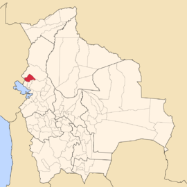
| Location in Bolivia | |
|---|---|
 |
|
| General Data | |
| Capital | Charazani Charazani - Location :Charazani is the capital of Bautista Saavedra Province and central town of the Charazani Municipality. It is situated on a spur at an elevation of 3,200 m amsl between Cordillera Muñecas in the south and Cordillera Apolabamba in the north, on a Mapiri River tributary which itself flows... |
| Area Area Area is a quantity that expresses the extent of a two-dimensional surface or shape in the plane. Area can be understood as the amount of material with a given thickness that would be necessary to fashion a model of the shape, or the amount of paint necessary to cover the surface with a single coat... |
2,525 km² |
| Population Population A population is all the organisms that both belong to the same group or species and live in the same geographical area. The area that is used to define a sexual population is such that inter-breeding is possible between any pair within the area and more probable than cross-breeding with individuals... |
11,475 (2001) |
| Density Density The mass density or density of a material is defined as its mass per unit volume. The symbol most often used for density is ρ . In some cases , density is also defined as its weight per unit volume; although, this quantity is more properly called specific weight... |
4.5 inhabitants/km² (2001) |
| ISO 3166-2 ISO 3166-2 ISO 3166-2 is part of the ISO 3166 standard published by the International Organization for Standardization , and defines codes for the names of the principal subdivisions of all countries coded in ISO 3166-1... |
BO.LP.BS |
| La Paz Department | |
 |
|
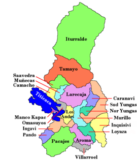
Bautista Saavedra is one of the twenty provinces of the Bolivia
Bolivia
Bolivia officially known as Plurinational State of Bolivia , is a landlocked country in central South America. It is the poorest country in South America...
n department
Departments of Bolivia
Bolivia is divided into nine departments . Each of the departments is subdivided into provinces , which are further subdivided into municipalities ....
of La Paz and is situated in the department's northwestern parts. The province's name honors Bautista Saavedra Mallea (1870-1939), Bolivia's president from 1920 to 1925.
Location
Bautista Saavedra province is located between 14° 45' and 15° 20' SouthLatitude
In geography, the latitude of a location on the Earth is the angular distance of that location south or north of the Equator. The latitude is an angle, and is usually measured in degrees . The equator has a latitude of 0°, the North pole has a latitude of 90° north , and the South pole has a...
and between 68° 18' and 69° 12' West
Longitude
Longitude is a geographic coordinate that specifies the east-west position of a point on the Earth's surface. It is an angular measurement, usually expressed in degrees, minutes and seconds, and denoted by the Greek letter lambda ....
. It extends over 65 km from North to South, and up to 90 km from West to East.
The province is situated on the Bolivian Altiplano
Altiplano
The Altiplano , in west-central South America, where the Andes are at their widest, is the most extensive area of high plateau on Earth outside of Tibet...
northeast of Lake Titicaca
Lake Titicaca
Lake Titicaca is a lake located on the border of Peru and Bolivia. It sits 3,811 m above sea level, making it the highest commercially navigable lake in the world...
and borders Franz Tamayo Province
Franz Tamayo Province
Franz Tamayo is a province in the Bolivian department of La Paz. It lies in the western part of the nation, and includes the Ulla Ulla National Reserve - which today is part of the Apolobamba Integrated Management Natural Area - in the high Andean plain on the western border with Peru...
in the Northeast to Northwest, Peru
Peru
Peru , officially the Republic of Peru , is a country in western South America. It is bordered on the north by Ecuador and Colombia, on the east by Brazil, on the southeast by Bolivia, on the south by Chile, and on the west by the Pacific Ocean....
in the West, Eliodoro Camacho Province
Eliodoro Camacho Province
Eliodoro Camacho is a province in the La Paz Department in Bolivia situated at Lake Titicaca. Its seat is Puerto Acosta.Camacho Province is situated in the western region of the La Paz Department bordered to the north by the Muñecas Province, to the east by the Larecaja Province, to the south by...
in the Southwest, and Muñecas Province
Muñecas Province
Muñecas is a province in the Bolivian department of La Paz. Its capital is Chuma.- Subdivision :The province is divided into three municipalities which are further subdivided into cantons.- External links :*...
and Larecaja Province
Larecaja Province
Larecaja is a province in the Bolivian department of La Paz. Its capital is Sorata.- Subdivision :Larecaja Province is divided into eight municipalities which are partly further subdivided into cantons.- Languages :...
in the Southeast. Madidi National Park
Madidi
Madidi is a national park in the upper Amazon river basin in Bolivia. Established in 1995, it has an area of 18,958 square kilometres, and along with nearby protected areas Manuripi-Heath, Apolobamba, and the Manu Biosphere Reserve...
is partially in this province.
Population
The population of Bautista Saavedra Province has increased by 30 % over the recent two decades:- 1992: 9,995 inhabitants (censusCensusA census is the procedure of systematically acquiring and recording information about the members of a given population. It is a regularly occurring and official count of a particular population. The term is used mostly in connection with national population and housing censuses; other common...
) - 2001: 11,475 inhabitants (censusCensusA census is the procedure of systematically acquiring and recording information about the members of a given population. It is a regularly occurring and official count of a particular population. The term is used mostly in connection with national population and housing censuses; other common...
) - 2005: 12,437 inhabitants (est.)
- 2010: 12,851 inhabitants (est.)
41.3 % of the population are younger than 15 years old. (1992)
46.6 % of the population speak Spanish
Spanish language
Spanish , also known as Castilian , is a Romance language in the Ibero-Romance group that evolved from several languages and dialects in central-northern Iberia around the 9th century and gradually spread with the expansion of the Kingdom of Castile into central and southern Iberia during the...
, 89.3 % speak Quechua, and 36.1 % Aymara. (2001)
The literacy rate
Literacy
Literacy has traditionally been described as the ability to read for knowledge, write coherently and think critically about printed material.Literacy represents the lifelong, intellectual process of gaining meaning from print...
of the province's population is 55.2 %. (1992)
94.3 % of the population have no access to electricity, 93.3 % have no sanitary facilities. (1992)
89.1 % of the population are Catholics, 5.7 % are Protestants. (1992)
Division
The province comprises two municipalitiesMunicipalities of Bolivia
Municipalities in Bolivia are administrative divisions of the entire national territory governed by local elections. Municipalities are the third level of administrative divisions, below departments and provinces. Some of the provinces consist of only one municipality...
:
- General Juan José Pérez MunicipalityGeneral Juan José Pérez MunicipalityGeneral Juan José Pérez Municipality or Charazani Municipality is the first municipal section of the Bautista Saavedra Province in the La Paz Department, Bolivia. Its seat is Charazani.- References :*...
- 9,841 inhabitants (est. 2005) - Curva MunicipalityCurva MunicipalityCurva Municipality is the second municipal section of the Bautista Saavedra Province in the La Paz Department, Bolivia. Its seat is Curva.- References :*...
- 2,596 inhabitants (est. 2005)