Barrios Unidos
Encyclopedia
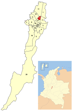
Barrios Unidos is the 12th locality of Bogotá
, capital of Colombia
. It is located in the city's north. Barrios Unidos is completely urban, with some light industry and major commercial areas.
South: Calle 63, bordering the locality of Teusaquillo
East: Autopista Norte
and Avenida Caracas
bordering the locality of Chapinero
.
West: Avenida 68, bordering the locality of Engativá
Avenida 80, Avenida Calle 68, Avenida NQS
, and Carrera 24. Calle 80 and Avenida NQS both have lines of the TransMilenio
system.
Among the commercial establishments are:
Barrios Unidos also is home to the Escuela de Cadetes General Santander military school.
Barrios
Siete de Agosto, Metrópolis, La Castellana, Polo Club, Patria, Modelo, San Fernando, 12 de Octubre, San Miguel, 11 de Noviembre, Rionegro, Andes, San Martín, Santa Sofía, Alcázares, Gaitán y.
Bogotá
Bogotá, Distrito Capital , from 1991 to 2000 called Santa Fé de Bogotá, is the capital, and largest city, of Colombia. It is also designated by the national constitution as the capital of the department of Cundinamarca, even though the city of Bogotá now comprises an independent Capital district...
, capital of Colombia
Colombia
Colombia, officially the Republic of Colombia , is a unitary constitutional republic comprising thirty-two departments. The country is located in northwestern South America, bordered to the east by Venezuela and Brazil; to the south by Ecuador and Peru; to the north by the Caribbean Sea; to the...
. It is located in the city's north. Barrios Unidos is completely urban, with some light industry and major commercial areas.
 Barrios Unidos in Bogotá |
|
| Area: | |
|---|---|
| Population: | 230.066 (2007) |
| Type of locality: | Urban |
Borders
North: Calle 100, bordering the locality of SubaSuba (Bogotá)
Suba is the 11th locality of the Capital District of the Colombian capital city, Bogotá. Suba is located north of the city, limiting to the north with the municipality of Chía in Cundinamarca Department, to the west with the municipality of Cota, to the east with the locality of Usaquén and to the...
South: Calle 63, bordering the locality of Teusaquillo
Teusaquillo
Teusaquillo is the 13th locality of Bogotá, capital of Colombia. It is located in the geographic center of the city, to the northwest of downtown. It is an urbanized locality with several green zones in its parks, avenues, and the campus of the National University of Colombia...
East: Autopista Norte
Autopista Norte (Bogotá)
Autopista Norte, also called Autopista paseo de los libertadores , is a major road in Bogotá, Colombia, running through the northern part of the city to its southern end at Avenida Caracas.-Names:...
and Avenida Caracas
Avenida Caracas (Bogotá)
Avenida Caracas, sometimes called Carrera 14, is an arterial road in Bogotá, Colombia that runs through the city from north to south.-Names:...
bordering the locality of Chapinero
Chapinero
Chapinero is the second locality of Bogotá, capital of Colombia. It is located in northeastern Bogotá. It is among the more affluent of localities in the city, and is home to several important commercial and dining areas. It comprises three major residential areas: Chicó, El Lago, and Chapinero...
.
West: Avenida 68, bordering the locality of Engativá
Engativá
Engativá, which translates to Chieftain of Inga, was a municipality of Cundinamarca, but became a locality of Bogotá, Colombia when Bogotá was made "Special District" .-Geographical location:...
Hydrology
Several rivers from the Salitre system pass through Barrios Unidos, including the Río Salitre.Transportation
In addition to the avenues that border the locality, the principal roads that serve it are:Avenida 80, Avenida Calle 68, Avenida NQS
Norte-Quito-Sur
Avenida Norte-Quito-Sur or NQS is an arterial road in Bogotá, Colombia that crosses the city from northeast to southwest.The avenue is formed from the union of three old avenues, Avenida Ciudad de Quito, Avenida Novena, and Autopista Sur.-The names:...
, and Carrera 24. Calle 80 and Avenida NQS both have lines of the TransMilenio
TransMilenio
TransMilenio is a bus rapid transit system that serves Bogotá, the capital of Colombia. The system opened to the public in December 2000, covering Av. Caracas and Calle 80...
system.
Economy
Small-scale industry thrives in the area, and it is home to Bogotá's leather, furniture, and footwear districts. Factory-direct storefronts are common throughout the locality. Specialty warehouses also exist, primarily focusing on autoparts.Points of interest
Part of Parque Metropolitano Simón Bolívar is located within Barrios Unidos:- El Lago Park
- Centro de Alto Rendimiento (fine arts center)
- Salitre Mágico Park
Among the commercial establishments are:
- Cafam Floresta
- Metrópolis shopping center
Barrios Unidos also is home to the Escuela de Cadetes General Santander military school.
Barrios
Los principales barrios de la localidad son los Siguientes:
Siete de Agosto, Metrópolis, La Castellana, Polo Club, Patria, Modelo, San Fernando, 12 de Octubre, San Miguel, 11 de Noviembre, Rionegro, Andes, San Martín, Santa Sofía, Alcázares, Gaitán y.

