
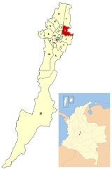
Chapinero
Encyclopedia
 Chapinero in Bogotá |
|
| Area: | 38.98 km² |
|---|---|
| Population: | 122.507 (2007) |
| Type of locality: | Mixed |
Chapinero is the second locality of Bogotá
Bogotá
Bogotá, Distrito Capital , from 1991 to 2000 called Santa Fé de Bogotá, is the capital, and largest city, of Colombia. It is also designated by the national constitution as the capital of the department of Cundinamarca, even though the city of Bogotá now comprises an independent Capital district...
, capital of Colombia
Colombia
Colombia, officially the Republic of Colombia , is a unitary constitutional republic comprising thirty-two departments. The country is located in northwestern South America, bordered to the east by Venezuela and Brazil; to the south by Ecuador and Peru; to the north by the Caribbean Sea; to the...
. It is located in northeastern Bogotá. It is among the more affluent of localities in the city, and is home to several important commercial and dining areas. It comprises three major residential areas: Chicó, El Lago, and Chapinero. It also contains a principal connecting point between the city and the eastern municipalities of Cundinamarca
Cundinamarca Department
- Origin of the name :The name of Cundinamarca comes from Kundur marqa, an indigenous expression, probably derived from Quechua. Meaning "Condor's Nest", it was used in pre-Columbian times by the natives of the Magdalena Valley to refer to the nearby highlands....
.
History
When the Special District of Bogotá was formed in 1955, the area was made into a locality. At that time the El Lago, Chicó, and Cataluña neighborhoods were added into the locality. The physical boundaries remained the same under the reorganization into the Capital District that took place in 1991.
Together with La Candelaria
La Candelaria
La Candelaria is a historic neighborhood in downtown Bogotá, Colombia. It is the equivalent to the Old City in other cities. The architecture of the old houses, churches and buildings has Spanish Colonial and Baroque styles...
and Teusaquillo
Teusaquillo
Teusaquillo is the 13th locality of Bogotá, capital of Colombia. It is located in the geographic center of the city, to the northwest of downtown. It is an urbanized locality with several green zones in its parks, avenues, and the campus of the National University of Colombia...
, Chapinero is one of the traditional neighborhoods that is distinctive of a particular era in the city's history and urban growth. A historically upper-class neighborhood, Chapinero is famous for its large, Victorian houses which reflect the influence of European architectural styles in Bogotá
Bogotá
Bogotá, Distrito Capital , from 1991 to 2000 called Santa Fé de Bogotá, is the capital, and largest city, of Colombia. It is also designated by the national constitution as the capital of the department of Cundinamarca, even though the city of Bogotá now comprises an independent Capital district...
at the beginning of the 20th century.
Economy and Culture
Chapinero is one of the most important commercial and economic zones of the capital city. Banking and financial centers are headquartered along Calle 72, with major shopping centers located along Carreras 11 and 15. Several universities are based in the locality, including the Pontificia Universidad Javeriana, Catholic University of ColombiaCatholic University of Colombia
The Catholic University of Colombia is a private institution of higher education. It was founded in Bogotá, Colombia in 1970, noting in his early loyalty to the Catholic Church doctrine. The institution now has 10,300 undergraduates...
Universidad Piloto de Colombia, and the Universidad Pedagógica Nacional.
The zone also includes popular dining areas and nightlife centers, which include the Zona Rosa, the Parque de la 93, and the Zona G; the last one known for its wide offer of gastronomic options.
The localty of Chapinero is also the center of Bogotá's gay community. There are more than 100 bars, discos and clubs that cater to the gay community in Bogotá, and 45% of these can be found in Chapinero. The biggest and most popular gay disco in Bogota, Theatron, is located in the heart of Chapinero. Furthermore, the mayor of Chapinero, Blanca Inés Durán Hernández, is openly lesbian.
The localty has a unique community center focused on the LGBT population of the neighborhood and the city. It is the first of its kind in Latin America.
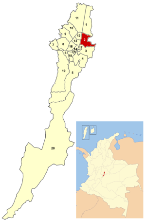
Borders
North: Calle 100, bordering the locality of UsaquénUsaquén
Usaquén is a residential and commercial locality in northern Bogotá, capital of Colombia. Although it is designated on maps as Bogotá's #1 locality, it was a separate municipality of Cundinamarca until 1954, when it was annexed into the city. Today, Usaquén is home of more than 480.000 inhabitants...
.
East: the eastern mountains, bordering the municipalities of La Calera and Choachí.
South: Calle 39, bordering the locality of Santa Fe
Santa Fe (Bogotá)
Santa Fe is the third locality of Bogotá, Capital District of Colombia. Santa Fe is the traditional downtown of the city of Bogotá. This area once comprised Bogotá's total main urban area and was known as "Santa Fe de Bogotá" with its traditional neighborhoods.Santa Fe is one of Bogotá's most...
.
West: Avenida Caracas
Avenida Caracas (Bogotá)
Avenida Caracas, sometimes called Carrera 14, is an arterial road in Bogotá, Colombia that runs through the city from north to south.-Names:...
and Autopista Norte
Autopista Norte (Bogotá)
Autopista Norte, also called Autopista paseo de los libertadores , is a major road in Bogotá, Colombia, running through the northern part of the city to its southern end at Avenida Caracas.-Names:...
, with the localities of Barrios Unidos
Barrios Unidos
Barrios Unidos is the 12th locality of Bogotá, capital of Colombia. It is located in the city's north. Barrios Unidos is completely urban, with some light industry and major commercial areas.- Borders :North: Calle 100, bordering the locality of Suba...
and Teusaquillo
Teusaquillo
Teusaquillo is the 13th locality of Bogotá, capital of Colombia. It is located in the geographic center of the city, to the northwest of downtown. It is an urbanized locality with several green zones in its parks, avenues, and the campus of the National University of Colombia...
.
Points of interest
- Chicó Museum (Museo del Chicó)
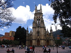
- Our Lady of Lourdes Church (Iglesia de Nuestra Señora de Lourdes)
- 93rd street park (93 Park93 Park93 Park or 93rd Street Park is a Commercial and recreation park located over the 93 Street in the north of Bogota, Colombia. Is one of Bogota's most popular shopping, night clubs and restaurant areas...
; Parque de la 93) - Shopping centers:
- Chile Avenue (Avenida Chile), formerly known as Bigsavings (Granahorrar)
- Andean Center (Centro Andino)
- Atlantis Plaza
- The Retirement (El Retiro)
Transportation
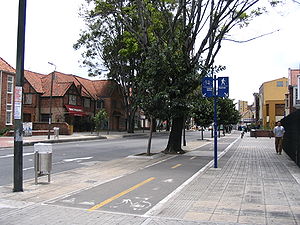
Major east-west roads include Calles 39, 45, 53, 57, 63, 85, 92, 94, 100, and Avenida Chile (Calle 72). North-south routes include Carreras 7, 9, 11, 13, 15 and Avenida Caracas.The locality is served by the Avenida Caracas line of TransMilenio
TransMilenio
TransMilenio is a bus rapid transit system that serves Bogotá, the capital of Colombia. The system opened to the public in December 2000, covering Av. Caracas and Calle 80...
, with a Carrera 7 line planned. All of the major roads have extensive private bus service.
Neighborhoods
El Nogal, El Chicó, Antiguo Country, RosalesRosales (Bogotá)
Rosales is a wealthy neighborhood in Bogotá, Colombia, specifically within the Chapinero district. The neighborhood is sprawling with beautiful, red brick highrises that creep up from Bogotá's principal artery, Carrera Septima , to the winding highway, La Circunvalar, that connects downtown Bogotá...
, Villa del Cerro, Chapinero Central, Chapinero Alto, La Cabrera, El Lago, El Virrey, Quinta Camacho, Pardo Rubio, Marly, La Salle, Bosque Calderón and La Porciúncula.
Before 1955, the term Chapinero included some neighborhoods that are now part of the Teusaquillo locality and did not included the El Lago, Chicó, and Cataluña neighborhoods that are currently part of the locality.