

Suba (Bogotá)
Encyclopedia
Colombia
Colombia, officially the Republic of Colombia , is a unitary constitutional republic comprising thirty-two departments. The country is located in northwestern South America, bordered to the east by Venezuela and Brazil; to the south by Ecuador and Peru; to the north by the Caribbean Sea; to the...
n capital city, Bogotá
Bogotá
Bogotá, Distrito Capital , from 1991 to 2000 called Santa Fé de Bogotá, is the capital, and largest city, of Colombia. It is also designated by the national constitution as the capital of the department of Cundinamarca, even though the city of Bogotá now comprises an independent Capital district...
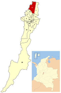
. Suba is located north of the city, limiting to the north with the municipality of Chía
Chía, Cundinamarca
Chía is a town and municipality in the Cundinamarca department of Colombia, located to the north of Bogotá on the main road to Zipaquira. Its history dates back to the pre-Columbian era. The name comes from the Chibchan language and means "moon" or "month"....
in Cundinamarca Department
Cundinamarca Department
- Origin of the name :The name of Cundinamarca comes from Kundur marqa, an indigenous expression, probably derived from Quechua. Meaning "Condor's Nest", it was used in pre-Columbian times by the natives of the Magdalena Valley to refer to the nearby highlands....
, to the west with the municipality of Cota
Cota, Colombia
Cota is a municipality and town of Colombia in the department of Cundinamarca.Jose Nestor Gonzalez Romero is the mayor of Cota.-External links:...
, to the east with the locality of Usaquén
Usaquén
Usaquén is a residential and commercial locality in northern Bogotá, capital of Colombia. Although it is designated on maps as Bogotá's #1 locality, it was a separate municipality of Cundinamarca until 1954, when it was annexed into the city. Today, Usaquén is home of more than 480.000 inhabitants...
and to the south with the locality of Engativá
Engativá
Engativá, which translates to Chieftain of Inga, was a municipality of Cundinamarca, but became a locality of Bogotá, Colombia when Bogotá was made "Special District" .-Geographical location:...
. its name comes from the Chibcha-Muisca
Muisca
Muisca was the Chibcha-speaking tribe that formed the Muisca Confederation of the central highlands of present-day Colombia. They were encountered by the Spanish Empire in 1537, at the time of the conquest...
word "Zhuba" meaning "my face" or "my grain"
Quinoa
Quinoa , a species of goosefoot , is a grain-like crop grown primarily for its edible seeds. It is a pseudocereal rather than a true cereal, or grain, as it is not a member of the grass family...
Geography
Suba has certain green areas mostly concentrated to the west of the locality, on the Hills of Suba and the Hills of La Conejera as well as the plains where urbanization has developed. Suba has become a residential area with small industrial and commercial zones located to the south of the locality. It is also crossed by a small mountain range that includes the hills of Suba and La Conejera separating Suba in two areas; the eastern side being more integrated to the urban area of Bogota.The locality borders specifically to the north with the Bogotá River
Bogotá River
The Bogotá River is a major river of the Cundinamarca department of Colombia, crossing the region from the northeast to the southwest and passing along the western limits of Bogotá...
and the 220th Street and the municipality of Chia
Chía, Cundinamarca
Chía is a town and municipality in the Cundinamarca department of Colombia, located to the north of Bogotá on the main road to Zipaquira. Its history dates back to the pre-Columbian era. The name comes from the Chibchan language and means "moon" or "month"....
. To the south with the Juan Amarillo River and the 100th Street and the localities of Engativá
Engativá
Engativá, which translates to Chieftain of Inga, was a municipality of Cundinamarca, but became a locality of Bogotá, Colombia when Bogotá was made "Special District" .-Geographical location:...
and Barrios Unidos
Barrios Unidos
Barrios Unidos is the 12th locality of Bogotá, capital of Colombia. It is located in the city's north. Barrios Unidos is completely urban, with some light industry and major commercial areas.- Borders :North: Calle 100, bordering the locality of Suba...
. To the east with the Autopista Norte
Autopista Norte (Bogotá)
Autopista Norte, also called Autopista paseo de los libertadores , is a major road in Bogotá, Colombia, running through the northern part of the city to its southern end at Avenida Caracas.-Names:...
and the locality of Usaquén
Usaquén
Usaquén is a residential and commercial locality in northern Bogotá, capital of Colombia. Although it is designated on maps as Bogotá's #1 locality, it was a separate municipality of Cundinamarca until 1954, when it was annexed into the city. Today, Usaquén is home of more than 480.000 inhabitants...
and to the west again with the Bogotá river and the municipality of Cota
Cota, Colombia
Cota is a municipality and town of Colombia in the department of Cundinamarca.Jose Nestor Gonzalez Romero is the mayor of Cota.-External links:...
.
Besides the Bogota and Juan Amarillo rivers the locality of Suba is covered by other streams and wetlands like the Torca wetland, Guaymaral, La Conejera, Cordoba and the Tibabuyes Lagoon.
Transport
The Suba AvenueAvenida Suba (Bogotá)
Avenida Suba is a major road in northern Bogotá, Colombia, connecting the locality of Suba with the rest of the capital.-Names:Avenida Suba is so named for being the principal vehicular access to the locality of the same name...
is the main road of Suba and the one that connects eastern with western Suba. Other major streets include the City of Cali Avenue to the west and the Autopista Norte
Autopista Norte (Bogotá)
Autopista Norte, also called Autopista paseo de los libertadores , is a major road in Bogotá, Colombia, running through the northern part of the city to its southern end at Avenida Caracas.-Names:...
to the east.
Since April 29, 2006 the mass-transit system TransMilenio
TransMilenio
TransMilenio is a bus rapid transit system that serves Bogotá, the capital of Colombia. The system opened to the public in December 2000, covering Av. Caracas and Calle 80...
covers the area throughout the Autopista Norte
Autopista Norte (Bogotá)
Autopista Norte, also called Autopista paseo de los libertadores , is a major road in Bogotá, Colombia, running through the northern part of the city to its southern end at Avenida Caracas.-Names:...
with its "B Line"; Portal del Norte
Portal del Norte (TransMilenio)
Portal del Norte is one of the terminus stations of the TransMilenio mass-transit system of Bogotá, Colombia, which opened in the year 2000.-Location:Portal del Norte is located in northern Bogotá, specifically on Autopista Norte with Calle 175....
, Toberín
Toberín (TransMilenio)
The simple station Toberín is part of the TransMilenio mass-transit system of Bogotá, Colombia, which opened in the year 2000.-Location:The station is located in northern Bogotá, specifically on Autopista Norte with calle 165....
, Cardio Infantil
Cardio Infantil (TransMilenio)
The simple station Cardio Infantil is part of the TransMilenio mass-transit system of Bogotá, Colombia, which opened in the year 2000.-Location:The station is located in northern Bogotá, specifically on Autopista Norte with Calle 161....
, Mazurén
Mazurén (TransMilenio)
The simple station Mazurén is part of the TransMilenio mass transit system of Bogotá, Colombia, which opened in the year 2000.-Location:The station is located in northern Bogotá, specifically on Autopista Norte with Calle 152....
, Calle 146
Calle 146 (TransMilenio)
The simple station Calle 146 is part of the TransMilenio mass-transit system of Bogotá, Colombia, which opened in the year 2000.-Location:The station is located in northern Bogotá, specifically on Autopista Norte with Calle 150....
, Calle 142
Calle 142 (TransMilenio)
The simple station Calle 142 is part of the TransMilenio mass-transit system of Bogotá, Colombia, which opened in the year 2000.-Location:The station is located in northern Bogotá, specifically on Autopista Norte with Calle 144....
, Alcalá
Alcalá (TransMilenio)
The simple station Alcalá is part of the TransMilenio mass-transit system of Bogotá, Colombia, which opened in the year 2000.-Location:The station is located in northern Bogotá, specifically on Autopista Norte with Calle 136....
, Prado
Prado (TransMilenio)
The simple station Prado is part of the TransMilenio mass-transit system of Bogotá, Colombia, which opened in the year 2000.-Location:The station is located in northern Bogotá, specifically on Autopista Norte with Calle 128 B....
, Calle 127
Calle 127 (TransMilenio)
The simple station Calle 127 is part of the TransMilenio mass-transit system of Bogotá, Colombia, which opened in the year 2000.-Location:The station is located in northern Bogotá, specifically on Autopista Norte with Calle 125....
, Pepe Sierra
Pepe Sierra (TransMilenio)
The simple station Pepe Sierra is part of the TransMilenio mass-transit system of Bogotá, Colombia, which opened in the year 2000.-Location:The station is located in northern Bogotá, specifically on Autopista Norte with Calle 115....
, Calle 106
Calle 106 (TransMilenio)
The simple station Calle 106 is part of the TransMilenio mass-transit system of Bogotá, Colombia, which opened in the year 2000.-Location:The station is located in northern Bogotá, specifically on Autopista Norte with Calle 105....
and Avenida Suba
Avenida Suba (Bogotá)
Avenida Suba is a major road in northern Bogotá, Colombia, connecting the locality of Suba with the rest of the capital.-Names:Avenida Suba is so named for being the principal vehicular access to the locality of the same name...
with its "C Line"; Portal de Suba
Portal de Suba (TransMilenio)
El Portal de Suba is one of the terminus stations of the TransMilenio mass-transit system of Bogotá, Colombia, which opened in the year 2000.-Location:...
, La Campiña
La Campiña (TransMilenio)
The simple station La Campiña is part of the TransMilenio mass-transit system of Bogotá, Colombia, which opened in the year 2000.-Location:The station is located in northwestern Bogotá, specifically on Avenida Suba between Carreras 98B and 100....
, Suba-Transversal 91
Suba Transversal 91 (TransMilenio)
The simple station Suba-Transversal 91, or Suba - Tv.91 by its abbreviation, is part of the TransMilenio mass-transit system of Bogotá, Colombia, which opened in the year 2000.-Location:...
, 21 Ángeles
21 Ángeles (TransMilenio)
The simple station 21 Ángeles is part of the TransMilenio mass-transit system of Bogotá, Colombia, which opened in the year 2000.-Location:The station is located in northwestern Bogotá, specifically on Avenida Suba with Transversal 84....
, Gratamira
Gratamira (TransMilenio)
The simple station Gratamira is part of the TransMilenio mass-transit system of Bogotá, Colombia, which opened in the year 2000.-Location:The station is located in northwestern Bogotá, specifically on Avenida Suba with Calle 132A....
, Suba-Boyacá Avenue
Suba Avenida Boyacá (TransMilenio)
The simple station Suba-Avenida Boyacá is part of the TransMilenio mass-transit system of Bogotá, Colombia, which opened in 2000.-Location:The station is located in northwestern Bogotá on Avenida Suba at its intersection with Avenida Boyacá ....
, Niza Calle 127
Niza Calle 127 (TransMilenio)
The simple station Niza Calle 127 is part of the TransMilenio mass-transit system of Bogotá, Colombia, which opened in the year 2000.-Location:The station is located in northwestern Bogotá, specifically on Avenida Suba with Calles 127 and 127D....
, Humedal Córdoba
Humedal Córdoba (TransMilenio)
The simple station Humedal Córdoba is part of the TransMilenio mass-transit system of Bogotá, Colombia, which opened in the year 2000.-Location:The station is located in northwestern Bogotá, specifically on Avenida Suba, between las Calles 120 and 121....
, Shaio
Shaio (TransMilenio)
The simple station Shaio is part of the TransMilenio mass-transit system of Bogotá, Colombia, which opened in the year 2000.-Location:The station is located in northwestern Bogotá, specifically between Calle 115 and calle 116 ....
, Puente Largo
Puente Largo (TransMilenio)
The simple station Puente Largo is part of the TransMilenio mass-transit system of Bogotá, Colombia, which opened in the year 2000.-Location:The station is located in northwestern Bogotá, specifically on Avenida Suba with Transversal 44....
, Suba Calle 100
Suba Calle 100 (TransMilenio)
The simple station Suba Calle 100 is part of the TransMilenio mass-transit system of Bogotá, Colombia, which opened in the year 2000.-Location:The station is located in northwestern Bogotá, specifically on Avenida Suba with Calle 100....
, Suba Calle 95
Suba Calle 95 (TransMilenio)
The simple station Suba Calle 95 is part of the TransMilenio mass-transit system of Bogotá, Colombia, which opened in the year 2000.-Location:The station is located in northwestern Bogotá, specifically on Avenida Suba with Calle 95....
, Rionegro
Rionegro (TransMilenio)
The simple station Rionegro is part of the TransMilenio mass-transit system of Bogotá, Colombia, which opened in the year 2000.-Location:The station is located in northwestern Bogotá, specifically on Avenida Suba with Calle 91....
and San Martín
San Martín (TransMilenio)
The simple station San Martín is part of the TransMilenio mass-transit system of Bogotá, Colombia, which opened in the year 2000.-Location:The station is located in northwestern Bogotá, specifically on Avenida Suba with Calle 83.-History:...
.
Other avenues like Boyaca Avenue, Ciudad de Cali Avenue, 134th and 170th Street are still covered by regular bus companies. There is also an inter-municipal highway that connects the locality of Suba with the municipality of Cota in Cundinamarca Department.
Economy
The main economic activity of Suba relies in the cultivation of export quality flowers, services and commerce, specially of large shopping centers like Bulevar Niza, Centro Suba, Plaza Imperial and Centro Comercial Santa Fe.Territorial subdivision
Suba is formed by a Regional Forest Reserrve Zone called La Conejera located to on the western side of the locality and 12 Units of Zone Planning (Unidades de Planeamiento Zonal, UPZ) which are: La Academia, Guaymaral, San José de Bavaria, Britalia, El Prado, La Alhambra, La Floresta, Niza, Casablanca, Suba centro, El Rincón and Tibabuyes.History
In the last ice ageIce age
An ice age or, more precisely, glacial age, is a generic geological period of long-term reduction in the temperature of the Earth's surface and atmosphere, resulting in the presence or expansion of continental ice sheets, polar ice sheets and alpine glaciers...
the climate in the region of Suba was of a páramo
Páramo
The term páramo can refer to a variety of ecosystems. Some ecologists describe the páramo broadly as “all high, tropical, montane vegetation above the continuous timberline”. A more narrow term classifies the páramo according to its regional placement - specifically located in “the northern Andes...
and andean forest. Since 10,500 BC groups of humans inhabited the area and practiced hunting and gathering. Since 3500 BC these hunters and gatherers began to domesticate animals, cultivate and create arts and crafts. By 500 BC maize and potato were predominantly cultivated and by the year 800 the Muiscas as culture inhabited the area. During the Spanish colonization of America, in 1538 the Muiscas were preserved in a Resguardo located in the area of Suba. In 1550 Antonio Días Cardoso and Hernán Camilo Monsilva founded the village of Suba.
On June 22, 1850 the Resguardo of the Muiscas in Suba was closed and the indigenous peoples forced away from the urban areas. This process continued until the year 1877.
On November 16, 1875 Suba was then declared a territory free of indigenous peoples and became a satellite municipality of Bogota. It became a municipality by decree during the Sovereign State of Cundinamarca. The rural area then was divided into landlords and peasants.
In 1954 the municipality was formally anexed to the "Special District of Bogotá" during the dictatorship of Gustavo Rojas Pinilla
Gustavo Rojas Pinilla
Gustavo Rojas Pinilla was a Colombian politician, military officer, General of the Army and President of Colombia between 1953 and 1957.- Biographic data :...
while still keeping its municipality status. In 1977 became a minor cityhall of Bogota and in 1991 was elevated to a locality of the renamed Capital District.
In 1990 the indigenous peoples of Suba and their towns were legally recognized by the government and ratified in the Colombian Constitution of 1991
Colombian Constitution of 1991
The Political Constitution of Colombia, better known as the Constitution of 1991, is the current governing document of the Republic of Colombia. Promulgated on July 4 of 1991 , it replaced the Constitution of 1886...
. In 1992 and 2001 the Cabildo
Cabildo
Cabildo can refer to:* Cabildo , a former Spanish municipal administrative unit governed by a council* Cabildo , African ethnic associations in colonial Cuba* Cabildo , an Argentine nationalist Catholic magazine...
Muisca of Suba and the Cabildo Muisca of Bosa respectively were legally recognized in an official ceremony with the participation of the then Mayor of Bogotá Antanas Mockus
Antanas Mockus
Aurelijus Rutenis Antanas Mockus Šivickas is a Colombian mathematician, philosopher, and politician.The son of Lithuanian immigrants, he left his post as the president of the National University of Colombia in Bogotá in 1993, and later that year ran a successful campaign for mayor...
as estipulated in the Law 89 of 1890 and after more than a century without legal existence, it was also ratified in 2005.ratificado
Indigenous population
According to the numbers provided by the respective Cabildos, the Muisca population of Suba is estimated to be of 5186 people.The following are the indigenous last names with their origin in Suba: Niviayo, Bulla, Cabiativa, Caita, Nivia, Chisaba, Muzuzu, Neuque, Yopasá, Quinche,
Sites of interests
- Hills of Suba and La Conejera
- Wetlands of Córdoba, Juan Amarillo and La Conejera
- Headquearters of the Indigenous peoples CabildoCabildoCabildo can refer to:* Cabildo , a former Spanish municipal administrative unit governed by a council* Cabildo , African ethnic associations in colonial Cuba* Cabildo , an Argentine nationalist Catholic magazine...
- Central Park of Suba
- Viewpoint of Los Nevados
Southeastern neighborhoods
The southeastern zone includes the sectors of Niza, Las Villas and Bulevar. The neighborhoods of Andes, La Floresta, Puente Largo, Pontevedra, Santa Rosa, San Nicolás, Morato, La Alhambra, Malibú, Recreo de los Frayles, Batán, Niza, Córdoba, Las Villas, Calatrava, Casablanca, Colina Campestre, Prado Veraniego and Mazurén.Northeastern neighborhoods
The northeastern zone includes the neighborhoods of San José de Bavaria, Del Monte, Granada Norte, Villa del Prado, Nueva Zelandia, Santa Catalina, Mirandela, Vilanova, Guicaní and San Pedro.Southwestern neighborhoods
The southwestern neighborhoods includes the sector of main Suba; The neighborhoods of Suba, La Campiña, Pinares, Tuna baja, La pradera, Nuevo Suba, Aures 1 and Aures 2, Alcaparros, Cataluña, Costa Azul, Lagos de Suba, Corinto, El Laguito Villa Maria, La Chucua Norte, El Rosal de Suba, El Rincón, El Rubí, Bilbao, fontanar del río, La Gaitana, Tibabuyes, Lisboa, Berlín y Villa Cindy, Sabana de Tibabuyes.Northwestern neighborhoods
To the north there is the sector of Guaymaral, to the northeast La Academia and to the west the sector of Corpas which has a Clinic of the same name. This also includes the numerous veredas where the export quality flowers are cultivated primarily on the highway to the town of CotaCota, Colombia
Cota is a municipality and town of Colombia in the department of Cundinamarca.Jose Nestor Gonzalez Romero is the mayor of Cota.-External links:...
, near the Marshall Sucre Military School .