
Barnehurst
Encyclopedia
Wards of the United Kingdom
A ward in the United Kingdom is an electoral district at sub-national level represented by one or more councillors. It is the primary unit of British administrative and electoral geography .-England:...
in the London Borough of Bexley
London Borough of Bexley
The London Borough of Bexley lies in south east Greater London, and is a borough referred to as part of Outer London. It has common borders with the London Borough of Bromley to the south, the London Borough of Greenwich to the west, across the River Thames to the north it borders the London...
, England
England
England is a country that is part of the United Kingdom. It shares land borders with Scotland to the north and Wales to the west; the Irish Sea is to the north west, the Celtic Sea to the south west, with the North Sea to the east and the English Channel to the south separating it from continental...
. It is a suburban development in Southeast London located 12.5 miles (20 km) east south-east of Charing Cross
Charing Cross
Charing Cross denotes the junction of Strand, Whitehall and Cockspur Street, just south of Trafalgar Square in central London, England. It is named after the now demolished Eleanor cross that stood there, in what was once the hamlet of Charing. The site of the cross is now occupied by an equestrian...
.
History
The town came into being after the sale of land in 1881 to build the Bexleyheath loop lineBexleyheath Line
The Bexleyheath Line runs for 8 miles from Blackheath to Dartford in Kent operating between the North Kent Line just to the east of Blackheath station and to the same line south of Slade Green in Dartford.-History:...
between Lewisham and Dartford
Dartford railway station
Dartford railway station serves the town of Dartford in Kent, England. All train services from the station are operated by Southeastern, which also manages the station...
.
Barnehurst's name originates from the name of the railway station, which was so-named after Colonel Barne, who owned a local property, May Place House (and was vice-chairman of the railway company).
As in much of suburban London, Barnehurst railway station
Barnehurst railway station
Barnehurst railway station serves Barnehurst, London Borough of Bexley: it is 13.9 miles from Central London on the Bexleyheath Line...
was opened to encourage building of houses. The Barnehurst Estate was built in 1926 and other building, mainly by W.H. Wedlock followed in the years after. A key landmark, just west of the station, is the Red Barn pub, a venue important to the survival of jazz in Britain immediately following the Second World War, largely due to the enthusiasm of pianist George Webb.
In 1920 the area became part of the Crayford Urban District
Crayford Urban District
Crayford was a local government district in north west Kent from 1920 to 1965 around the town of Crayford. As well as Crayford, it included Barnehurst, Barnes Cray and Slade Green.It was created an urban district in 1920 from part of Dartford Rural District....
of Kent
Kent
Kent is a county in southeast England, and is one of the home counties. It borders East Sussex, Surrey and Greater London and has a defined boundary with Essex in the middle of the Thames Estuary. The ceremonial county boundaries of Kent include the shire county of Kent and the unitary borough of...
. In 1965, under the London Government Act 1963
London Government Act 1963
The London Government Act 1963 is an Act of the Parliament of the United Kingdom, which recognised officially the conurbation known as Greater London and created a new local government structure for the capital. The Act significantly reduced the number of local government districts in the area,...
, the urban district was abolished and its area transferred to Greater London to form part of the present-day London Borough of Bexley.
Political
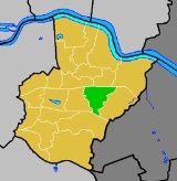
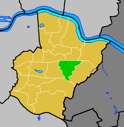
Most of Barnehurst is in the Barnehurst ward of the London Borough of Bexley - local Councillors are Richard Gillespie, Simon Windle, and Bill McEwen (all ConservativeConservative Party (UK)
The Conservative Party, formally the Conservative and Unionist Party, is a centre-right political party in the United Kingdom that adheres to the philosophies of conservatism and British unionism. It is the largest political party in the UK, and is currently the largest single party in the House...
). The northern-most part of Barnehurst is in Colyers ward
Colyers ward
Colyers is an electoral ward in the London Borough of Bexley. It consists of parts of Barnehurst, Erith and Northumberland Heath. Ward Councillors are Brian Bishop, Maxine Fothergill and Chris Taylor ....
and part of one road, Eversley Avenue, lies within North End
North End (Bexley ward)
North End is an electoral ward in the London Borough of Bexley which consists of Slade Green, the eastern part of Erith and a tiny part of Barnehurst, along with parts of Northend. Community interests are represented by , which is a registered charity...
ward.
Education
- For education in Barnehurst see the main London Borough of Bexley article
Nearest places
- BexleyheathBexleyheathBexleyheath is a main suburban district of Southeast London, England, in the London Borough of Bexley with a small percentage of the district itself being in the London Borough of Greenwich. Bexleyheath is located on the border of Inner London and Outer London. It is east south-east of Charing Cross...
- CrayfordCrayfordCrayford is a town and electoral ward in the London Borough of Bexley that was an important bridging point in Roman times across the River Cray, a tributary of the River Darent, which is itself a tributary of the River Thames.-History:...
- Northumberland HeathNorthumberland HeathNorthumberland Heath is a neighbourhood and electoral ward within the London Borough of Bexley, south east London, England. Northumberland Heath is often referred to locally as "North' Heath" and is often considered to be part of upper Erith.-History:...
- Slade GreenSlade GreenSlade Green is a place in south- east London closer to the edge of London located in the London Borough of Bexley. It is a suburban development situated east-southeast of Charing Cross and lying south of the River Thames slightly to the west of the River Darenth and River Cray.-History and...
- Barnes CrayBarnes CrayBarnes Cray is a place in the London Borough of Bexley. Its name derives from the prominent local Barne family.Up until the Victorian era it was a hamlet a kilometre downstream of Crayford where no more than sixteen homes were clustered...
Rail
The nearest station is Barnehurst railway stationBarnehurst railway station
Barnehurst railway station serves Barnehurst, London Borough of Bexley: it is 13.9 miles from Central London on the Bexleyheath Line...
on the Bexleyheath line. Trains run between London Charing Cross, London Victoria or London Cannon Street, via Lewisham
Lewisham
Lewisham is a district in South London, England, located in the London Borough of Lewisham. It is situated south-east of Charing Cross. The area is identified in the London Plan as one of 35 major centres in Greater London.-History:...
and Eltham to the west and Dartford railway station
Dartford railway station
Dartford railway station serves the town of Dartford in Kent, England. All train services from the station are operated by Southeastern, which also manages the station...
to the east. Some trains go to Slade Green
Slade Green
Slade Green is a place in south- east London closer to the edge of London located in the London Borough of Bexley. It is a suburban development situated east-southeast of Charing Cross and lying south of the River Thames slightly to the west of the River Darenth and River Cray.-History and...
, Crayford
Crayford
Crayford is a town and electoral ward in the London Borough of Bexley that was an important bridging point in Roman times across the River Cray, a tributary of the River Darent, which is itself a tributary of the River Thames.-History:...
, Gravesend
Gravesend, Kent
Gravesend is a town in northwest Kent, England, on the south bank of the Thames, opposite Tilbury in Essex. It is the administrative town of the Borough of Gravesham and, because of its geographical position, has always had an important role to play in the history and communications of this part of...
and Woolwich
Woolwich
Woolwich is a district in south London, England, located in the London Borough of Greenwich. The area is identified in the London Plan as one of 35 major centres in Greater London.Woolwich formed part of Kent until 1889 when the County of London was created...
in peak hours. During off peak there are 12 trains per hour overall; 4 trains per hour to Dartford
Dartford
Dartford is the principal town in the borough of Dartford. It is situated in the northwest corner of Kent, England, east south-east of central London....
, 2 to London Charing Cross, 2 to London Victoria and 2 to London Cannon Street
There are 4 trains per hour on Sunday overall; 2 to Dartford and 2 to Charing Cross
Buses
- 89London Buses route 89London Buses route 89 is a Transport for London contracted bus route in London, United Kingdom. The service is currently contracted to Go-Ahead London.-History:...
- LewishamLewishamLewisham is a district in South London, England, located in the London Borough of Lewisham. It is situated south-east of Charing Cross. The area is identified in the London Plan as one of 35 major centres in Greater London.-History:...
Station and Slade GreenSlade GreenSlade Green is a place in south- east London closer to the edge of London located in the London Borough of Bexley. It is a suburban development situated east-southeast of Charing Cross and lying south of the River Thames slightly to the west of the River Darenth and River Cray.-History and...
Station - 229London Buses route 229London Buses route 229 is a Transport for London contracted bus route in London, England. The service is currently contracted to Go-Ahead London.-History:...
- ThamesmeadThamesmeadThamesmead is a district of south-east London, England, located in the London Boroughs of Greenwich and Bexley. It is situated east of Charing Cross....
Town Centre and SidcupSidcupSidcup is a district in South East London in the London Borough of Bexley and small parts of the district in the London Borough of Greenwich.Located south east of Charing Cross, Sidcup is bordered by the London Boroughs of Greenwich and Bromley and Kent County Council, and whilst now part of...
Queen Marys Hospital - 99 - BexleyheathBexleyheathBexleyheath is a main suburban district of Southeast London, England, in the London Borough of Bexley with a small percentage of the district itself being in the London Borough of Greenwich. Bexleyheath is located on the border of Inner London and Outer London. It is east south-east of Charing Cross...
shopping centre and WoolwichWoolwichWoolwich is a district in south London, England, located in the London Borough of Greenwich. The area is identified in the London Plan as one of 35 major centres in Greater London.Woolwich formed part of Kent until 1889 when the County of London was created...
Beresford Street - N89 - ErithErithErith is a district of southeast London on the River Thames. Erith's town centre has undergone a series of modernisations since 1961.-Pre-medieval:...
Town Centre and Trafalgar SquareTrafalgar SquareTrafalgar Square is a public space and tourist attraction in central London, England, United Kingdom. At its centre is Nelson's Column, which is guarded by four lion statues at its base. There are a number of statues and sculptures in the square, with one plinth displaying changing pieces of... - 492 - SidcupSidcupSidcup is a district in South East London in the London Borough of Bexley and small parts of the district in the London Borough of Greenwich.Located south east of Charing Cross, Sidcup is bordered by the London Boroughs of Greenwich and Bromley and Kent County Council, and whilst now part of...
Station and Bluewater Shopping Centre
Religious sites
- Saint Martin of Tours, *(Saint Martin's), The Parish Church of Barnehurst, Erith Road. Vicar, The Rev'd. Gareth Bowen 01322 523344.
- Barnehurst Methodist Church, Risedale Road
- Lynhurst Chapel (first church building in Barnehurst Village)
- Selah Independent Baptist Church