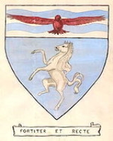
Crayford Urban District
Encyclopedia
Crayford was a local government district in north west Kent
from 1920 to 1965 around the town of Crayford
. As well as Crayford, it included Barnehurst
, Barnes Cray
and Slade Green
.
It was created an urban district
in 1920 from part of Dartford Rural District
.
In 1965 it was abolished by the London Government Act 1963
and its former area transferred to Greater London
from Kent. Its former area was combined with that of other districts to form the present-day London Borough of Bexley
.
Kent
Kent is a county in southeast England, and is one of the home counties. It borders East Sussex, Surrey and Greater London and has a defined boundary with Essex in the middle of the Thames Estuary. The ceremonial county boundaries of Kent include the shire county of Kent and the unitary borough of...
from 1920 to 1965 around the town of Crayford
Crayford
Crayford is a town and electoral ward in the London Borough of Bexley that was an important bridging point in Roman times across the River Cray, a tributary of the River Darent, which is itself a tributary of the River Thames.-History:...
. As well as Crayford, it included Barnehurst
Barnehurst
Barnehurst is a town and electoral ward in the London Borough of Bexley, England. It is a suburban development in Southeast London located 12.5 miles east south-east of Charing Cross.-History:...
, Barnes Cray
Barnes Cray
Barnes Cray is a place in the London Borough of Bexley. Its name derives from the prominent local Barne family.Up until the Victorian era it was a hamlet a kilometre downstream of Crayford where no more than sixteen homes were clustered...
and Slade Green
Slade Green
Slade Green is a place in south- east London closer to the edge of London located in the London Borough of Bexley. It is a suburban development situated east-southeast of Charing Cross and lying south of the River Thames slightly to the west of the River Darenth and River Cray.-History and...
.
It was created an urban district
Urban district
In the England, Wales and Ireland, an urban district was a type of local government district that covered an urbanised area. Urban districts had an elected Urban District Council , which shared local government responsibilities with a county council....
in 1920 from part of Dartford Rural District
Dartford Rural District
Dartford Rural District was a rural district with an area of in the county of Kent, England. In 1971 it had a population of 64,561 and an electorate of 43,911...
.
In 1965 it was abolished by the London Government Act 1963
London Government Act 1963
The London Government Act 1963 is an Act of the Parliament of the United Kingdom, which recognised officially the conurbation known as Greater London and created a new local government structure for the capital. The Act significantly reduced the number of local government districts in the area,...
and its former area transferred to Greater London
Greater London
Greater London is the top-level administrative division of England covering London. It was created in 1965 and spans the City of London, including Middle Temple and Inner Temple, and the 32 London boroughs. This territory is coterminate with the London Government Office Region and the London...
from Kent. Its former area was combined with that of other districts to form the present-day London Borough of Bexley
London Borough of Bexley
The London Borough of Bexley lies in south east Greater London, and is a borough referred to as part of Outer London. It has common borders with the London Borough of Bromley to the south, the London Borough of Greenwich to the west, across the River Thames to the north it borders the London...
.

