
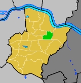
Colyers ward
Encyclopedia

Wards of the United Kingdom
A ward in the United Kingdom is an electoral district at sub-national level represented by one or more councillors. It is the primary unit of British administrative and electoral geography .-England:...
in the London Borough of Bexley
London Borough of Bexley
The London Borough of Bexley lies in south east Greater London, and is a borough referred to as part of Outer London. It has common borders with the London Borough of Bromley to the south, the London Borough of Greenwich to the west, across the River Thames to the north it borders the London...
. It consists of parts of Barnehurst
Barnehurst
Barnehurst is a town and electoral ward in the London Borough of Bexley, England. It is a suburban development in Southeast London located 12.5 miles east south-east of Charing Cross.-History:...
, Erith
Erith
Erith is a district of southeast London on the River Thames. Erith's town centre has undergone a series of modernisations since 1961.-Pre-medieval:...
and Northumberland Heath
Northumberland Heath
Northumberland Heath is a neighbourhood and electoral ward within the London Borough of Bexley, south east London, England. Northumberland Heath is often referred to locally as "North' Heath" and is often considered to be part of upper Erith.-History:...
. Ward Councillors are Brian Bishop, Maxine Fothergill and Chris Taylor (all Conservative).
The ward covers Colyers Lane, a local main road that is 1.5 km (0.93205910497471 mi) long east to west, and the surrounding area. Northend Road, part of the A206 road
A206 road
The A206 road links Greenwich with Greenhithe following the line of the River Thames. Today it is approximately 15 miles in length, although the final section is a relatively new road. Its primary purpose is to link into the London Orbital motorway at the Dartford Crossing and is heavily used by...
passes the east side of Colyers travelling, north to south it forms some of the ward's eastern boundary. The A220 road passes north to south on the western side of Colyers and forms some of the western boundary; it is named Bexley Road to the north and Erith Road to the south. The ward's southern boundary follows some of railway line east of Barnehurst railway station
Barnehurst railway station
Barnehurst railway station serves Barnehurst, London Borough of Bexley: it is 13.9 miles from Central London on the Bexleyheath Line...
the on the Bexleyheath Line
Bexleyheath Line
The Bexleyheath Line runs for 8 miles from Blackheath to Dartford in Kent operating between the North Kent Line just to the east of Blackheath station and to the same line south of Slade Green in Dartford.-History:...
.
External links
- Colyers Ward Web Page - http://colyers-conservatives.jimdo.com/
Cllr Chris Taylor's web page http://christaylor.yourcllr.com/