
Bansagar
Encyclopedia
ISAT
ISAT can stand for:*Integrated Science and Technology*International Subarachnoid Aneurysm Trial*Illinois Standards Achievement Test*Idaho Standards Achievement Test*International Student Admission Test*International Schools Association of Thailand...
:, Hindi
Hindi
Standard Hindi, or more precisely Modern Standard Hindi, also known as Manak Hindi , High Hindi, Nagari Hindi, and Literary Hindi, is a standardized and sanskritized register of the Hindustani language derived from the Khariboli dialect of Delhi...
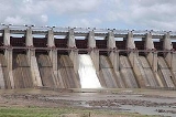
:बाणसागर) is a multipurpose Rriver Valley Project on Son River
Son River
Son River of central India is the largest of the Ganges' southern tributaries. A British 1850s diary shows that the river was written in English as Soane.-Course:...
situated in Ganga Basin in Madhya Pradesh
Madhya Pradesh
Madhya Pradesh , often called the Heart of India, is a state in central India. Its capital is Bhopal and Indore is the largest city....
, India
India
India , officially the Republic of India , is a country in South Asia. It is the seventh-largest country by geographical area, the second-most populous country with over 1.2 billion people, and the most populous democracy in the world...
envisaging both irrigation
Irrigation
Irrigation may be defined as the science of artificial application of water to the land or soil. It is used to assist in the growing of agricultural crops, maintenance of landscapes, and revegetation of disturbed soils in dry areas and during periods of inadequate rainfall...
and hydroelectric power generation.
The Bansagar Dam across Sone River has been constructed at village Deolond
Deolond
Deolond is a village in the Shahdol district of Madhya Pradesh in India situated at a distance of from Rewa on Rewa – Shahdol road. It is also the site of construction of the high Bansagar Dam on the Son River. The village gets its name from Deol Rishi....
in Shahdol
Shahdol
Shahdol is a city in Shahdol district in the Indian state of Madhya Pradesh. It is the administrative headquarters of Shahdol District.Shahdol is also the 10th Division of Madhya Pradesh state, including shahdol, anuppur, umaria, and dindori district....
district on Rewa
Rewa, India
Rewa is formerly the capital of the princely state of Rewa and former state of Vindhya Pradesh in central India. It is an important city in the North Eastern part of Madhya Pradesh state of India bordering Allahabad, Mirzapur and Banda Districts of Uttar Pradesh and Satna and Sidhi Districts of...
– Shahdol
Shahdol
Shahdol is a city in Shahdol district in the Indian state of Madhya Pradesh. It is the administrative headquarters of Shahdol District.Shahdol is also the 10th Division of Madhya Pradesh state, including shahdol, anuppur, umaria, and dindori district....
road, at a distance of 51.4 km from Rewa. The project has been named as “Bansagar” after Bana Bhatt
Banabhatta
Bāṇabhaṭṭa , also known as Bāṇa, was a Sanskrit scholar and poet of India. He was the Asthana Kavi in the court of King Harshavardhana, who reigned in the years c. 606–647 CE in north India...
, the renowned Sanskrit
Sanskrit
Sanskrit , is a historical Indo-Aryan language and the primary liturgical language of Hinduism, Jainism and Buddhism.Buddhism: besides Pali, see Buddhist Hybrid Sanskrit Today, it is listed as one of the 22 scheduled languages of India and is an official language of the state of Uttarakhand...
scholar of 7th century, who is believed to have hailed from this region in India. Bansagar Dam is located at Latitude
Latitude
In geography, the latitude of a location on the Earth is the angular distance of that location south or north of the Equator. The latitude is an angle, and is usually measured in degrees . The equator has a latitude of 0°, the North pole has a latitude of 90° north , and the South pole has a...
24-11-30 N and Longitude
Longitude
Longitude is a geographic coordinate that specifies the east-west position of a point on the Earth's surface. It is an angular measurement, usually expressed in degrees, minutes and seconds, and denoted by the Greek letter lambda ....
81-17-15 E.
The project was initially envisaged as "Dimba Project" in 1956 by Central Water Commission, New Delhi to be constructed on Sone River at the confluence of Sone and Banas River
Banas River
The Banas is a river of Rajasthan state in western India. It is a tributary of the Chambal River, which in turn flows into the Yamuna, a tributary of the Ganges. The Banas is approximately 512 kilometres in length. It is also known as 'Van Ki Asha' .The Banas originates in the Khamnor Hills of the...
near Shikarganj town 30 km down the present site. Later it was shifted to the present site at Deolond
Deolond
Deolond is a village in the Shahdol district of Madhya Pradesh in India situated at a distance of from Rewa on Rewa – Shahdol road. It is also the site of construction of the high Bansagar Dam on the Son River. The village gets its name from Deol Rishi....
. There was an agreement in 1973 between the State Governments of Madhya Pradesh
Madhya Pradesh
Madhya Pradesh , often called the Heart of India, is a state in central India. Its capital is Bhopal and Indore is the largest city....
, Uttar Pradesh
Uttar Pradesh
Uttar Pradesh abbreviation U.P. , is a state located in the northern part of India. With a population of over 200 million people, it is India's most populous state, as well as the world's most populous sub-national entity...
and Bihar
Bihar
Bihar is a state in eastern India. It is the 12th largest state in terms of geographical size at and 3rd largest by population. Almost 58% of Biharis are below the age of 25, which is the highest proportion in India....
for the construction of the Dam, according to which States had to share the expenditure in the ratio of 2:1:1. The sharing of 4 maf water is also to be done by the states in the same ratio. The construction work was started in year 1978 at original approved cost of Rs. 91.31 crores. The latest estimated cost in 1998 was Rs. 1054.96 crores.
Bansagar Dam and reservoir data
- Catchment area : 18648 km²
- Dam height : 67 metre
- Dam length : 1020 metre
- Dam type : Masonry/Earthen
- Spillway capacity : 47742 m³/s
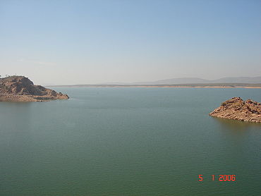
- Live storage : 5.41 km³
- Submergence area : 587.54 km²
- Population affected : 250000 persons (54686 families)
- Villages submerged : 336
- Year of start : 1978
- Year of completion : 2006
Irrigation
The water sharing from Bansagar Dam is as under:- Madhya PradeshMadhya PradeshMadhya Pradesh , often called the Heart of India, is a state in central India. Its capital is Bhopal and Indore is the largest city....
: 2000000 acre.ft - Uttar PradeshUttar PradeshUttar Pradesh abbreviation U.P. , is a state located in the northern part of India. With a population of over 200 million people, it is India's most populous state, as well as the world's most populous sub-national entity...
: 1000000 acre.ft - BiharBiharBihar is a state in eastern India. It is the 12th largest state in terms of geographical size at and 3rd largest by population. Almost 58% of Biharis are below the age of 25, which is the highest proportion in India....
: 1000000 acre.ft
Bansagar will provide irrigation
Irrigation
Irrigation may be defined as the science of artificial application of water to the land or soil. It is used to assist in the growing of agricultural crops, maintenance of landscapes, and revegetation of disturbed soils in dry areas and during periods of inadequate rainfall...
facility over an area of 2,490 km² in Madhya Pradesh
Madhya Pradesh
Madhya Pradesh , often called the Heart of India, is a state in central India. Its capital is Bhopal and Indore is the largest city....
, 1,500 km²; in Uttar Pradesh
Uttar Pradesh
Uttar Pradesh abbreviation U.P. , is a state located in the northern part of India. With a population of over 200 million people, it is India's most populous state, as well as the world's most populous sub-national entity...
and 940 km² in Bihar
Bihar
Bihar is a state in eastern India. It is the 12th largest state in terms of geographical size at and 3rd largest by population. Almost 58% of Biharis are below the age of 25, which is the highest proportion in India....
.
Bansagar Canal Project
The Bansagar Canal Project was also started in 1978 and is likely to be completed in year 2008. Following Canal System, which will utilize water from the Bansagar Reservoir, are in progress as under:| Canal System | Length (km) | Annual irrigation (ha) |
|---|---|---|
| Common Water Carrier | 36.57 | No direct irrigation |
| Right Bank Canal | 30.80 | 5059 |
| Bhitari Canal | 11.20 | 2730 |
| Sihawal Canal | 75.30 | 27143 |
| Keoti canal | 90.00 | 45528 |
| Purwa Canal | 128.90 | 74084 |
| Gurh Mauganj Canal | 65.00 | 24654 |
| Teonthar Lift Canal | 40.96 | 14161 |
Submergence of Bansagar
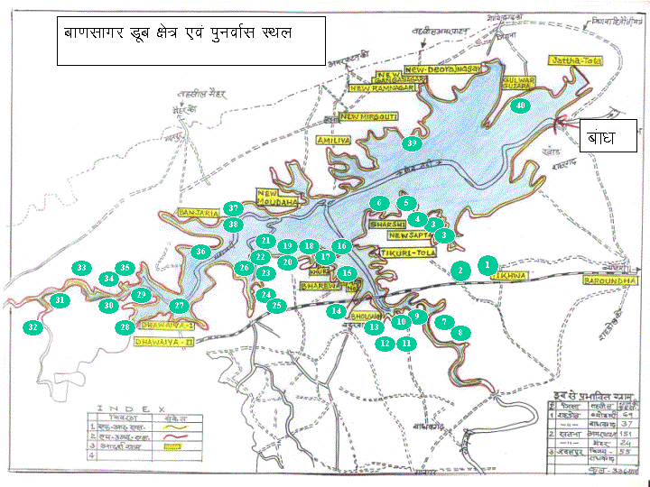
Total 336 villages have come under submergence of Bansagar Reservoir out of which 79 villages are fully submerged and rest 257 villages are under partial submergence.
Fully submerged villages
All the 79 fully submerged villages in Bansagar have been displaced and lost their geographical existence from the map. Some of historically important villages submerged fully are RamnagarRamnagar, Madhya Pradesh
Ramnagar is a town in Madhya Pradesh state in central India. It is located on the Son River in Satna District, approximately 60 kilometers from the city of Satna.Ramnagar was formerly in the control of the BaghelVans or BaghelRajah of Rewa District....
, Deorajnagar, Baraundha
Baraundha
Baraundha was a princely state of colonial India, located in modern Satna district of Madhya Pradesh. Although historically far larger, at the time of Indian independence in 1947, it was a petty sanad state of about 565 km2. The ruling family, members of the Raghuvansi line of Rajputs, had held...
, Markandeya
Markandeya
Markandeya is an ancient rishi from the Hindu tradition, born in the clan of Bhrigu Rishi. He is celebrated as a devotee of both Shiva and Vishnu and is mentioned in a number of stories from the Puranas...
-ghat, Darbar etc. The district wise details of these submerged and lost villages are as under:
Satna districtSatna DistrictSatna District , was formed in 1948, is a district of Madhya Pradesh state in central India. The town of Satna is the district headquarters. The district has an area of 7,502 km², and a population of 1,868,648 , 20.63% of which was urban...
(48 villages)
Amjhori Dakshin,Baikona No.-2,
Bela (Near Remar),
Bamhauri (Bimhauri),
Barauli,
Baikona No.-1,
Bara,
Barsajaha,
Bela Tiwari,
Banneh,
Chhirahai,
Deoraj nagar,
Dhol baja,
Dala,
Daga Kothar,
Dighiya Khurd,
Garehara,
Gurha,
Hinauta Khurd (Unumukt),
Hinauta Khothar,
Itma (Near Deoraj Nagar),
Itma (Near Ram Nagar),
Jarmani,
Jirauha,
Kusmaha,
Khajura,
Khajuri,
Kauhara,
Kareha bela,
Kothar,
Karahiya,
Kalla Khurd,
Kalla Kala,
Ladwad No.-1,
Ladwad No.-2,
Mala Dabar,
Mirgauti,
Mohari Khurd,
Patha,
Patehari,
Poriya,
Parariya,
Pipari Dakshin,
Rimar,
Semariha,
Semra,
Singhpur,
Semariya (Sanaga),
Tilokawa
Shahdol districtShahdol DistrictShahdol District is a district of Madhya Pradesh state in central India. With a total area of 5,671 square kilometers and a population of 908,148. Shahdol is an important district of Madhya Pradesh. The town of Shahdol is the district headquarters. The district is also a Division...
(22 villages)
Bodra,Barundha,
Dhanedi Purva,
Dhaneda,
Dhanedi Pashchim,
Dhanedi Vikram,
Ghusira,
Jamun Darhi,
Jhirkona,
Kusiara,
Karahiya,
Karri,
Karaundiya Pashchim,
Karaundiya Purva,
Karaundiya Kothar,
Kanbau,
Kachhara Tola,
Marha,
Magaraha,
Palwahi,
Pahariya,
Sonvarsha
Dedicated to nation
The foundation of ambitious Bansagar project was laid by Late Prime Minister Morarji DesaiMorarji Desai
Morarji Ranchhodji Desai was an Indian independence activist and the fourth Prime Minister of India from 1977–79. He was the first Indian Prime Minister who did not belong to the Indian National Congress...
on 14 May 1978.
The Bansagar Dam was dedicated to nation on 25 September 2006 by Atal Bihari Vajpayee
Atal Bihari Vajpayee
Atal Bihari Vajpayee is an Indian statesman who served as the tenth Prime Minister of India three times – first for a brief term of 13 days in 1996, and then for two terms from 1998 to 2004. After his first brief period as Prime Minister in 1996, Vajpayee headed a coalition government from...
, former Prime Minister of India
Prime Minister of India
The Prime Minister of India , as addressed to in the Constitution of India — Prime Minister for the Union, is the chief of government, head of the Council of Ministers and the leader of the majority party in parliament...
.
See also
- River Basins in Madhya PradeshRiver Basins in Madhya PradeshThere are ten river basins in Madhya Pradesh as ten major rivers originate from the State. As Madhya Pradesh is located in the center of India, most of the rivers are interstate rivers. The rivers namely, Chambal, Sindh, Betwa, Ken flow northward and meet with Yamuna whereas the river Sone falls...
- Dams in Madhya Pradesh